Kentucky city limits map
Kentucky has 419 incorporated cities. They cover 4.9% of the state’s land and are home to 56% of its residents. Everyone else lives outside city limits, where local government is the county. Enter an address to see which side of a city line it’s on.
Result for
The map couldn’t load. The answers don’t depend on it.
The boundary couldn’t load. The answer doesn’t depend on it.
Census Geocoder match
More about this address
Sources and limits
- Census
- US Census Bureau Geocoder, current boundaries
- FEMA
- National Flood Hazard Layer, effective flood maps
- USDA
- Rural Development property eligibility
- Map
- Boundaries from Census TIGERweb, flood zones drawn by FEMA, eligible areas from USDA, base map © OpenStreetMap contributors
Census boundaries are updated once a year, so a recent annexation may not show yet. Informational only, not an official determination. Verify with your city or county.
Kentucky at a glance
- Incorporated places
- 419
- 419 cities
- Residents in city limits
- 56%
- 2,545,106 of 4,534,824
- Land in city limits
- 4.9%
- 1,916 of 39,486 sq mi
- Counties
- 120
- 1 with no city
- Unincorporated communities
- 136
- Largest: Burlington (18,008)
- Largest city
- Louisville/Jefferson County
- 631,818 residents
City limits maps for 2 Kentucky cities
Every Kentucky city with 100,000 or more residents has its own page: the boundary in detail, the places around it and its school districts.
All 419 cities in Kentucky
Every incorporated place, largest first, with the counties it’s in and its size. An address inside one of these is inside city limits; anywhere else in the state is unincorporated.
| Name | County | Population | Land (sq mi) |
|---|---|---|---|
| Louisville/Jefferson County | Jefferson | 631,818 | 262.8 |
| Lexington-Fayette | Fayette | 323,725 | 283.9 |
| Bowling Green | Warren | 75,388 | 42.0 |
| Owensboro | Daviess | 60,302 | 21.3 |
| Covington | Kenton | 41,110 | 13.2 |
| Georgetown | Scott | 39,117 | 17.9 |
| Richmond | Madison | 37,111 | 22.3 |
| Florence | Boone | 32,803 | 11.2 |
| Elizabethtown | Hardin | 32,576 | 28.3 |
| Nicholasville | Jessamine | 32,197 | 15.5 |
| Hopkinsville | Christian | 30,906 | 32.8 |
| Independence | Kenton | 29,392 | 17.8 |
| Jeffersontown | Jefferson | 29,199 | 10.9 |
| Frankfort | Franklin | 28,503 | 14.8 |
| Henderson | Henderson | 27,852 | 16.9 |
| Paducah | McCracken | 26,845 | 20.4 |
| Radcliff | Hardin | 22,864 | 13.5 |
| Ashland | Boyd | 21,295 | 10.7 |
| Erlanger | Kenton | 19,875 | 8.39 |
| Madisonville | Hopkins | 19,515 | 18.6 |
| Winchester | Clark | 19,213 | 9.26 |
| Mount Washington | Bullitt | 18,480 | 9.57 |
| Murray | Calloway | 18,080 | 11.7 |
| Shelbyville | Shelby | 17,668 | 10.9 |
| St. Matthews | Jefferson | 17,577 | 4.41 |
| Danville | Boyle | 17,327 | 18.1 |
| Fort Thomas | Campbell | 17,169 | 5.67 |
| Berea | Madison | 15,786 | 16.5 |
| Shively | Jefferson | 15,638 | 4.57 |
| Glasgow | Barren | 15,197 | 16.1 |
| Shepherdsville | Bullitt | 14,533 | 16.3 |
| Newport | Campbell | 13,967 | 2.76 |
| Bardstown | Nelson | 13,804 | 12.1 |
| Somerset | Pulaski | 12,216 | 15.2 |
| Lawrenceburg | Anderson | 11,943 | 6.02 |
| Campbellsville | Taylor | 11,622 | 7.58 |
| Lyndon | Jefferson | 11,030 | 3.60 |
| Alexandria | Campbell | 10,562 | 6.92 |
| Versailles | Woodford | 10,492 | 6.49 |
| Franklin | Simpson | 10,360 | 15.1 |
| La Grange | Oldham | 10,311 | 7.22 |
| Paris | Bourbon | 10,160 | 7.95 |
| Mayfield | Graves | 9,868 | 7.35 |
| Middletown | Jefferson | 9,763 | 5.14 |
| Harrodsburg | Mercer | 9,313 | 6.92 |
| Elsmere | Kenton | 9,205 | 2.63 |
| Middlesborough | Bell | 9,123 | 7.38 |
| Hillview | Bullitt | 8,797 | 6.71 |
| Maysville | Mason | 8,737 | 19.0 |
| Fort Mitchell | Kenton | 8,713 | 3.10 |
| Edgewood | Kenton | 8,447 | 4.26 |
| Corbin | Whitley, Knox | 8,246 | 7.96 |
| Oak Grove | Christian | 7,962 | 10.7 |
| Union | Boone | 7,642 | 3.95 |
| London | Laurel | 7,561 | 11.7 |
| Mount Sterling | Montgomery | 7,551 | 4.49 |
| Pikeville | Pike | 7,490 | 20.8 |
| Villa Hills | Kenton | 7,480 | 3.60 |
| Russellville | Logan | 7,316 | 11.0 |
| Flatwoods | Greenup | 7,269 | 4.74 |
| Taylor Mill | Kenton | 6,937 | 6.11 |
| Morehead | Rowan | 6,870 | 9.67 |
| Vine Grove | Hardin | 6,830 | 6.87 |
| Leitchfield | Grayson | 6,819 | 10.8 |
| Cynthiana | Harrison | 6,458 | 4.64 |
| Highland Heights | Campbell | 6,444 | 2.62 |
| Lebanon | Marion | 6,430 | 6.84 |
| Crestwood | Oldham | 6,356 | 4.05 |
| Cold Spring | Campbell | 6,341 | 4.76 |
| Princeton | Caldwell | 6,241 | 8.99 |
| Wilmore | Jessamine | 6,057 | 4.98 |
| Fort Wright | Kenton | 5,887 | 3.40 |
| Monticello | Wayne | 5,753 | 6.09 |
| Dayton | Campbell | 5,743 | 1.30 |
| Walton | Boone, Kenton | 5,730 | 4.76 |
| Central City | Muhlenberg | 5,707 | 5.30 |
| Bellevue | Campbell | 5,636 | 0.91 |
| Douglass Hills | Jefferson | 5,474 | 1.33 |
| Williamsburg | Whitley | 5,270 | 4.17 |
| Hazard | Perry | 5,008 | 7.46 |
| Columbia | Adair | 4,808 | 4.87 |
| Benton | Marshall | 4,748 | 5.10 |
| Hurstbourne | Jefferson | 4,702 | 1.80 |
| Prospect | Jefferson | 4,542 | 3.83 |
| Crescent Springs | Kenton | 4,486 | 1.49 |
| Scottsville | Allen | 4,427 | 6.59 |
| Greenville | Muhlenberg | 4,410 | 5.13 |
| Ludlow | Kenton | 4,378 | 0.92 |
| Paintsville | Johnson | 4,203 | 6.63 |
| Crittenden | Grant | 4,084 | 3.41 |
| Lancaster | Garrard | 4,013 | 2.52 |
| Williamstown | Grant | 3,945 | 16.8 |
| Carrollton | Carroll | 3,915 | 2.04 |
| Grayson | Carter | 3,778 | 2.78 |
| Prestonsburg | Floyd | 3,765 | 14.7 |
| Southgate | Campbell | 3,717 | 1.46 |
| Russell | Greenup | 3,676 | 3.81 |
| Stanford | Lincoln | 3,643 | 4.79 |
| Beaver Dam | Ohio | 3,524 | 3.04 |
| Hodgenville | Larue | 3,389 | 2.41 |
| West Liberty | Morgan | 3,295 | 4.90 |
| Crestview Hills | Kenton | 3,284 | 1.90 |
| Stanton | Powell | 3,218 | 2.28 |
| Morganfield | Union | 3,185 | 2.81 |
| Park Hills | Kenton | 3,165 | 0.78 |
| Barbourville | Knox | 3,146 | 2.66 |
| Wilder | Campbell | 3,135 | 3.61 |
| Simpsonville | Shelby | 3,062 | 3.32 |
| Flemingsburg | Fleming | 2,965 | 2.69 |
| Brandenburg | Meade | 2,937 | 4.35 |
| Springfield | Washington | 2,899 | 4.65 |
| Eddyville | Lyon | 2,897 | 6.93 |
| Indian Hills | Jefferson | 2,897 | 1.98 |
| Marion | Crittenden | 2,886 | 3.63 |
| Providence | Webster | 2,857 | 6.03 |
| Lakeside Park | Kenton | 2,828 | 0.78 |
| Graymoor-Devondale | Jefferson | 2,802 | 0.74 |
| Russell Springs | Russell | 2,773 | 4.72 |
| Cave City | Barren | 2,730 | 4.87 |
| Eminence | Henry | 2,724 | 2.85 |
| Irvine | Estill | 2,723 | 1.46 |
| Pioneer Village | Bullitt | 2,723 | 1.23 |
| Cadiz | Trigg | 2,677 | 3.00 |
| Hartford | Ohio | 2,649 | 2.84 |
| Junction City | Boyle | 2,643 | 2.01 |
| Tompkinsville | Monroe | 2,613 | 3.28 |
| Louisa | Lawrence | 2,580 | 2.24 |
| Calvert City | Marshall | 2,526 | 17.9 |
| Anchorage | Jefferson | 2,506 | 2.96 |
| Morgantown | Butler | 2,479 | 3.33 |
| Falmouth | Pendleton | 2,449 | 1.36 |
| Dry Ridge | Grant | 2,441 | 5.16 |
| Mount Vernon | Rockcastle | 2,398 | 2.81 |
| Fulton | Fulton | 2,378 | 2.89 |
| Edmonton | Metcalfe | 2,330 | 3.81 |
| Hardinsburg | Breckinridge | 2,327 | 3.46 |
| Lebanon Junction | Bullitt | 2,327 | 5.64 |
| Raceland | Greenup | 2,265 | 2.48 |
| Carlisle | Nicholas | 2,214 | 1.34 |
| Harlan | Harlan | 2,160 | 1.36 |
| Horse Cave | Hart | 2,143 | 3.15 |
| Hickman | Fulton | 2,115 | 3.55 |
| Greensburg | Green | 2,106 | 2.03 |
| Beattyville | Lee | 2,095 | 2.30 |
| Windy Hills | Jefferson | 2,081 | 0.92 |
| Warsaw | Gallatin | 2,072 | 0.96 |
| Pineville | Bell | 2,064 | 3.37 |
| Lewisport | Hancock | 2,057 | 0.95 |
| Cumberland | Harlan | 2,037 | 3.11 |
| Jackson | Breathitt | 2,015 | 2.51 |
| Hurstbourne Acres | Jefferson | 1,972 | 0.35 |
| Worthington Hills | Jefferson | 1,957 | 0.26 |
| Dawson Springs | Hopkins | 1,951 | 3.84 |
| Elkton | Todd | 1,924 | 2.83 |
| Orchard Grass Hills | Oldham | 1,912 | 0.39 |
| Albany | Clinton | 1,896 | 2.27 |
| Munfordville | Hart | 1,893 | 2.24 |
| Sturgis | Union | 1,864 | 1.57 |
| Sebree | Webster | 1,825 | 2.94 |
| Auburn | Logan | 1,794 | 1.83 |
| St. Regis Park | Jefferson | 1,783 | 0.35 |
| Midway | Woodford | 1,776 | 1.43 |
| Whitesburg | Letcher | 1,761 | 3.13 |
| Worthington | Greenup | 1,759 | 1.14 |
| Jamestown | Russell | 1,739 | 3.67 |
| Coal Run Village | Pike | 1,724 | 8.75 |
| Salyersville | Magoffin | 1,708 | 2.47 |
| Audubon Park | Jefferson | 1,707 | 0.33 |
| Liberty | Casey | 1,672 | 1.87 |
| Jeffersonville | Montgomery | 1,651 | 3.49 |
| South Shore | Greenup | 1,642 | 0.70 |
| Olive Hill | Carter | 1,636 | 1.99 |
| Owingsville | Bath | 1,621 | 2.51 |
| West Buechel | Jefferson | 1,599 | 0.64 |
| Guthrie | Todd | 1,559 | 2.37 |
| Catlettsburg | Boyd | 1,557 | 1.33 |
| Manchester | Clay | 1,541 | 2.93 |
| Owenton | Owen | 1,511 | 1.90 |
| Augusta | Bracken | 1,510 | 1.19 |
| Taylorsville | Spencer | 1,496 | 0.94 |
| Pewee Valley | Oldham | 1,483 | 1.93 |
| Vanceburg | Lewis | 1,482 | 1.45 |
| Burkesville | Cumberland | 1,454 | 2.57 |
| Brodhead | Rockcastle | 1,423 | 1.75 |
| Bellefonte | Greenup | 1,419 | 0.88 |
| Jenkins | Letcher | 1,406 | 8.84 |
| Coldstream | Jefferson | 1,331 | 0.22 |
| Irvington | Breckinridge | 1,327 | 0.97 |
| Beechwood Village | Jefferson | 1,292 | 0.28 |
| Heritage Creek | Jefferson | 1,283 | 0.54 |
| Hebron Estates | Bullitt | 1,276 | 0.59 |
| Northfield | Jefferson | 1,250 | 0.47 |
| Barbourmeade | Jefferson | 1,247 | 0.40 |
| Livermore | McLean | 1,223 | 1.04 |
| Clay City | Powell | 1,204 | 1.06 |
| Hawesville | Hancock | 1,188 | 1.62 |
| Clinton | Hickman | 1,165 | 1.61 |
| Wurtland | Greenup | 1,154 | 1.77 |
| Cloverport | Breckinridge | 1,133 | 1.54 |
| Muldraugh | Meade, Hardin | 1,127 | 0.52 |
| Bloomfield | Nelson | 1,124 | 1.44 |
| Pleasureville | Henry, Shelby | 1,123 | 0.48 |
| Earlington | Hopkins | 1,084 | 2.82 |
| Brownsville | Edmonson | 1,068 | 2.61 |
| New Castle | Henry | 1,052 | 0.41 |
| Lewisburg | Logan | 1,043 | 1.16 |
| Dixon | Webster | 1,036 | 1.25 |
| West Point | Hardin | 1,025 | 2.66 |
| White Plains | Hopkins | 1,021 | 3.25 |
| Campbellsburg | Henry | 1,016 | 1.32 |
| Plantation | Jefferson | 1,013 | 0.20 |
| Silver Grove | Campbell | 1,008 | 1.18 |
| Clay | Webster | 996 | 0.86 |
| Stamping Ground | Scott | 994 | 0.59 |
| Burgin | Mercer | 993 | 1.26 |
| Goshen | Oldham | 989 | 0.20 |
| Rolling Hills | Jefferson | 982 | 0.19 |
| Perryville | Boyle | 970 | 0.78 |
| Wheelwright | Floyd | 964 | 1.76 |
| Hanson | Hopkins | 958 | 2.17 |
| Powderly | Muhlenberg | 931 | 1.56 |
| Inez | Martin | 930 | 1.72 |
| Langdon Place | Jefferson | 917 | 0.17 |
| Nortonville | Hopkins | 904 | 1.16 |
| McKee | Jackson | 888 | 2.41 |
| Brooksville | Bracken | 883 | 0.47 |
| Meadow Vale | Jefferson | 878 | 0.22 |
| Camargo | Montgomery | 874 | 2.19 |
| Uniontown | Union | 874 | 0.85 |
| Clarkson | Grayson | 865 | 1.06 |
| Woodlawn Park | Jefferson | 857 | 0.24 |
| Bellemeade | Jefferson | 851 | 0.29 |
| Ferguson | Pulaski | 849 | 1.96 |
| Elkhorn City | Pike | 846 | 7.83 |
| New Haven | Nelson | 837 | 0.58 |
| Bromley | Kenton | 821 | 0.37 |
| Millersburg | Bourbon, Nicholas | 819 | 0.41 |
| Greenup | Greenup | 813 | 2.11 |
| Wickliffe | Ballard | 797 | 1.55 |
| Hindman | Knott | 790 | 3.11 |
| Ryland Heights | Kenton | 789 | 5.29 |
| Smiths Grove | Warren | 786 | 0.78 |
| Salem | Livingston | 780 | 0.85 |
| Burnside | Pulaski | 755 | 4.50 |
| Houston Acres | Jefferson | 745 | 0.14 |
| Blue Ridge Manor | Jefferson | 743 | 0.19 |
| Corydon | Henderson | 741 | 0.54 |
| Crab Orchard | Lincoln | 739 | 1.75 |
| Bardwell | Carlisle | 737 | 0.86 |
| Watterson Park | Jefferson | 734 | 1.44 |
| Pembroke | Christian | 732 | 1.11 |
| Benham | Harlan | 725 | 0.23 |
| Fincastle | Jefferson | 717 | 0.21 |
| Adairville | Logan | 713 | 1.18 |
| Lynch | Harlan | 709 | 0.30 |
| Spring Valley | Jefferson | 707 | 0.20 |
| La Center | Ballard | 694 | 0.61 |
| Loretto | Marion | 683 | 3.20 |
| North Middletown | Bourbon | 679 | 0.33 |
| Park City | Barren | 670 | 1.47 |
| Whitesville | Daviess | 661 | 0.43 |
| Crofton | Christian | 655 | 0.63 |
| Sonora | Hardin | 653 | 1.89 |
| Mortons Gap | Hopkins | 650 | 1.24 |
| Evarts | Harlan | 648 | 0.38 |
| Science Hill | Pulaski | 647 | 0.78 |
| Rolling Fields | Jefferson | 645 | 0.23 |
| Frenchburg | Menifee | 643 | 0.84 |
| Ravenna | Estill | 642 | 0.31 |
| Lynnview | Jefferson | 641 | 0.19 |
| Milton | Trimble | 637 | 1.47 |
| Melbourne | Campbell | 627 | 0.84 |
| Kevil | Ballard | 624 | 0.57 |
| Hustonville | Lincoln | 612 | 0.84 |
| Fox Chase | Bullitt | 610 | 0.38 |
| Upton | Hardin, Larue | 606 | 1.36 |
| Wingo | Graves | 606 | 0.98 |
| Brownsboro Farm | Jefferson | 604 | 0.23 |
| Hollow Creek | Jefferson | 602 | 0.23 |
| Poplar Hills | Jefferson | 602 | 0.03 |
| Calhoun | McLean | 601 | 0.65 |
| Murray Hill | Jefferson | 594 | 0.13 |
| Green Spring | Jefferson | 589 | 0.27 |
| Kuttawa | Lyon | 588 | 2.19 |
| Parkway Village | Jefferson | 588 | 0.09 |
| Seneca Gardens | Jefferson | 586 | 0.15 |
| Island | McLean | 576 | 0.34 |
| Woodland Hills | Jefferson | 575 | 0.21 |
| Strathmoor Village | Jefferson | 574 | 0.10 |
| Fleming-Neon | Letcher | 567 | 1.61 |
| Barlow | Ballard | 564 | 0.55 |
| Glenview | Jefferson | 557 | 1.42 |
| Riverwood | Jefferson | 527 | 0.21 |
| Sharpsburg | Bath | 519 | 0.20 |
| Butler | Pendleton | 515 | 0.19 |
| Crestview | Campbell | 505 | 0.16 |
| Martin | Floyd | 494 | 0.73 |
| Wellington | Jefferson | 492 | 0.09 |
| Robards | Henderson | 483 | 3.03 |
| Bancroft | Jefferson | 479 | 0.15 |
| Moorland | Jefferson | 479 | 0.09 |
| Norbourne Estates | Jefferson | 476 | 0.08 |
| Caneyville | Grayson | 474 | 1.65 |
| Fredonia | Caldwell | 466 | 0.62 |
| Sandy Hook | Elliott | 456 | 0.98 |
| Fordsville | Ohio | 453 | 0.45 |
| Pippa Passes | Knott | 450 | 0.45 |
| Hardin | Marshall | 446 | 0.70 |
| River Bluff | Oldham | 445 | 0.24 |
| Bradfordsville | Marion | 444 | 0.27 |
| Kingsley | Jefferson | 442 | 0.07 |
| Grand Rivers | Livingston | 436 | 2.00 |
| Sanders | Carroll | 435 | 0.29 |
| Hollyvilla | Jefferson | 434 | 0.34 |
| Westwood | Jefferson | 432 | 0.12 |
| Norwood | Jefferson | 424 | 0.12 |
| Strathmoor Manor | Jefferson | 422 | 0.06 |
| Eubank | Pulaski, Lincoln | 412 | 0.85 |
| Plum Springs | Warren | 405 | 0.53 |
| Waverly | Union | 403 | 0.27 |
| Meadowview Estates | Jefferson | 390 | 0.08 |
| Spring Mill | Jefferson | 389 | 0.06 |
| Briarwood | Jefferson | 388 | 0.10 |
| Loyall | Harlan | 388 | 0.29 |
| Forest Hills | Jefferson | 387 | 0.29 |
| Bedford | Trimble | 386 | 0.39 |
| McHenry | Ohio | 385 | 0.65 |
| Trenton | Todd | 376 | 0.57 |
| Centertown | Ohio | 371 | 0.31 |
| Sadieville | Scott | 370 | 1.08 |
| Hunters Hollow | Bullitt | 357 | 0.07 |
| Gamaliel | Monroe | 352 | 0.79 |
| Richlawn | Jefferson | 351 | 0.10 |
| Creekside | Jefferson | 346 | 0.08 |
| Ewing | Fleming | 346 | 0.25 |
| Keene | Jessamine | 346 | 0.12 |
| Glenview Hills | Jefferson | 342 | 0.13 |
| Willisburg | Washington | 334 | 0.69 |
| Lakeview Heights | Rowan | 332 | 0.14 |
| Old Brownsboro Place | Jefferson | 332 | 0.13 |
| Bonnieville | Hart | 326 | 0.57 |
| Brownsboro Village | Jefferson | 325 | 0.07 |
| Hyden | Leslie | 325 | 1.30 |
| Drakesboro | Muhlenberg | 320 | 0.55 |
| Druid Hills | Jefferson | 320 | 0.09 |
| Glencoe | Gallatin | 319 | 1.76 |
| Woodburn | Warren | 319 | 0.43 |
| Sacramento | McLean | 317 | 0.43 |
| Wayland | Floyd | 316 | 2.71 |
| Bellewood | Jefferson | 308 | 0.08 |
| Hazel | Calloway | 299 | 0.35 |
| Warfield | Martin | 297 | 0.83 |
| St. Charles | Hopkins | 293 | 0.99 |
| Ghent | Carroll | 286 | 0.71 |
| Bremen | Muhlenberg | 285 | 0.21 |
| Oakland | Warren | 280 | 1.40 |
| Salt Lick | Bath | 274 | 0.78 |
| Campton | Wolfe | 272 | 1.00 |
| Sparta | Gallatin, Owen | 272 | 6.25 |
| Mentor | Campbell | 271 | 0.75 |
| Maryhill Estates | Jefferson | 268 | 0.04 |
| Goose Creek | Jefferson | 263 | 0.06 |
| Fountain Run | Monroe | 255 | 1.32 |
| Berry | Harrison | 253 | 0.25 |
| Dover | Mason | 247 | 0.43 |
| Rockport | Ohio | 233 | 0.69 |
| Germantown | Bracken, Mason | 232 | 0.12 |
| LaFayette | Christian | 227 | 0.26 |
| Corinth | Grant | 226 | 2.12 |
| Columbus | Hickman | 223 | 0.32 |
| Manor Creek | Jefferson | 221 | 0.06 |
| Wildwood | Jefferson | 220 | 0.07 |
| Nebo | Hopkins | 217 | 0.25 |
| Vicco | Perry, Knott | 217 | 0.84 |
| Broeck Pointe | Jefferson | 205 | 0.07 |
| Mackville | Washington | 204 | 0.40 |
| Smithland | Livingston | 203 | 0.51 |
| Fairfield | Nelson | 194 | 0.29 |
| Prestonville | Carroll | 192 | 0.22 |
| Thornhill | Jefferson | 192 | 0.05 |
| Crossgate | Jefferson | 189 | 0.05 |
| Booneville | Owsley | 187 | 1.46 |
| Livingston | Rockcastle | 187 | 0.31 |
| Arlington | Carlisle | 185 | 0.38 |
| Woodlawn | Campbell | 181 | 0.06 |
| Worthville | Carroll | 176 | 0.26 |
| Slaughters | Webster | 175 | 0.23 |
| Glenview Manor | Jefferson | 170 | 0.09 |
| Mount Olivet | Robertson | 170 | 0.83 |
| Cambridge | Jefferson | 167 | 0.06 |
| Kenton Vale | Kenton | 158 | 0.05 |
| Allen | Floyd | 157 | 0.18 |
| Hickory Hill | Jefferson | 157 | 0.03 |
| South Carrollton | Muhlenberg | 157 | 0.25 |
| Rochester | Butler | 155 | 0.47 |
| Smithfield | Henry | 153 | 0.14 |
| St. Mary | Marion | 147 | 0.78 |
| Mockingbird Valley | Jefferson | 138 | 0.21 |
| Hills and Dales | Jefferson | 134 | 0.10 |
| Ekron | Meade | 130 | 0.16 |
| Raywick | Marion | 125 | 0.90 |
| Lincolnshire | Jefferson | 124 | 0.05 |
| Fairview | Kenton | 120 | 0.73 |
| Sycamore | Jefferson | 118 | 0.02 |
| Ten Broeck | Jefferson | 111 | 0.22 |
| Meadowbrook Farm | Jefferson | 109 | 0.03 |
| Blandville | Ballard | 107 | 0.21 |
| Sardis | Mason, Robertson | 98 | 1.00 |
| Buckhorn | Perry | 95 | 0.34 |
| Monterey | Owen | 92 | 0.26 |
| Wheatcroft | Webster | 90 | 0.25 |
| Woodbury | Butler | 84 | 0.14 |
| Blaine | Lawrence | 80 | 0.28 |
| Gratz | Owen | 80 | 0.35 |
| California | Campbell | 49 | 0.22 |
| Carrsville | Livingston | 39 | 0.07 |
| Concord | Lewis | 5 | 0.06 |
| South Park View | Jefferson | 0 | 0.12 |
| Louisville | Jefferson | – | 61.5 |
Showing 1–50 of 419
Unincorporated communities in Kentucky
Census-designated places: named communities the Census Bureau maps for statistics, with no city government of their own. An address in one is outside city limits, even when its mailing address names a city. Kentucky has 136.
| Community | County | Population | Land (sq mi) |
|---|---|---|---|
| Burlington | Boone | 18,008 | 8.81 |
| Fort Campbell North | Christian | 11,356 | 8.53 |
| Francisville | Boone | 10,565 | 8.48 |
| Oakbrook | Boone | 10,211 | 3.20 |
| Fort Knox | Hardin | 8,836 | 20.3 |
| Hebron | Boone | 6,407 | 6.42 |
| Reidland | McCracken | 5,277 | 4.79 |
| Massac | McCracken | 4,698 | 4.04 |
| Hendron | McCracken | 4,495 | 5.34 |
| Westwood | Boyd | 4,473 | 3.74 |
| Farley | McCracken | 4,458 | 5.91 |
| Buckner | Oldham | 4,119 | 8.64 |
| Claryville | Campbell | 3,251 | 7.20 |
| Sorgho | Daviess | 2,960 | 4.74 |
| Masonville | Daviess | 2,887 | 10.4 |
| Thruston | Daviess | 2,581 | 1.76 |
| Rineyville | Hardin | 2,470 | 4.56 |
| Elk Creek | Spencer | 2,207 | 5.79 |
| North Corbin | Laurel | 2,190 | 1.71 |
| Brooks | Bullitt | 2,069 | 3.53 |
| Ledbetter | Livingston | 1,785 | 6.88 |
| Doe Valley | Meade | 1,776 | 4.06 |
| Breckinridge Center | Union | 1,467 | 2.62 |
| Verona | Boone | 1,394 | 12.2 |
| Plano | Warren | 1,290 | 1.03 |
| Stearns | McCreary | 1,271 | 4.02 |
| West Van Lear | Johnson | 1,155 | 1.09 |
| Cannonsburg | Boyd | 1,129 | 1.74 |
| Annville | Jackson | 1,063 | 8.01 |
| Pine Knot | McCreary | 1,051 | 6.40 |
| Philpot | Daviess | 1,036 | 3.28 |
| Whitley City | McCreary | 963 | 2.31 |
| Beechmont | Muhlenberg | 771 | 1.82 |
| Petersburg | Boone | 771 | 6.28 |
| South Wallins | Harlan | 765 | 6.31 |
| Buffalo | Larue | 735 | 1.18 |
| McDowell | Floyd | 718 | 2.48 |
| East Bernstadt | Laurel | 669 | 2.11 |
| Auxier | Floyd | 651 | 0.93 |
| Flat Lick | Knox | 634 | 4.78 |
| Magnolia | Larue | 609 | 2.04 |
| Cawood | Harlan | 596 | 1.46 |
| Yelvington | Daviess | 594 | 0.76 |
| Summersville | Green | 592 | 2.89 |
| Betsy Layne | Floyd | 557 | 1.81 |
| McRoberts | Letcher | 556 | 5.60 |
| Garrison | Lewis | 552 | 2.70 |
| Pathfork | Harlan | 542 | 1.24 |
| Summer Shade | Metcalfe | 532 | 2.03 |
| Cecilia | Hardin | 503 | 1.43 |
| Mayking | Letcher | 503 | 1.54 |
| Emlyn | Whitley | 488 | 0.71 |
| Pleasant Ridge | Daviess | 487 | 3.51 |
| Symsonia | Graves | 473 | 1.52 |
| South Williamson | Pike | 472 | 1.97 |
| Stanley | Daviess | 448 | 0.84 |
| Van Lear | Johnson | 443 | 4.07 |
| Payne Gap | Letcher | 440 | 2.30 |
| Gilbertsville | Marshall | 433 | 1.02 |
| Artemus | Knox | 426 | 1.35 |
| Virgie | Pike | 424 | 1.02 |
| Maceo | Daviess | 418 | 1.49 |
| Ironville | Boyd | 411 | 0.78 |
| Ages | Harlan | 385 | 0.56 |
| Wallins Creek | Harlan | 383 | 0.53 |
| Kenvir | Harlan | 358 | 0.29 |
| Chaplin | Nelson | 337 | 1.38 |
| Sedalia | Graves | 334 | 1.18 |
| Fancy Farm | Graves | 326 | 0.88 |
| Millstone | Letcher | 317 | 0.21 |
| Diablock | Perry | 315 | 0.20 |
| Ezel | Morgan | 313 | 0.89 |
| Bandana | Ballard | 311 | 1.89 |
| Jeff | Perry | 309 | 0.76 |
| Phelps | Pike | 301 | 7.99 |
| Beech Grove | McLean | 291 | 1.84 |
| Big Clifty | Grayson | 285 | 1.44 |
| Westport | Oldham | 275 | 0.81 |
| Moseleyville | Daviess | 269 | 1.04 |
| Cunningham | Carlisle | 265 | 1.05 |
| McCarr | Pike | 265 | 0.25 |
| Cerulean | Trigg | 263 | 2.55 |
| Belleview | Boone | 262 | 1.36 |
| Poole | Webster | 256 | 0.97 |
| Farmington | Graves | 245 | 1.53 |
| Knottsville | Daviess | 245 | 0.69 |
| Pleasant View | Whitley | 241 | 0.79 |
| Salvisa | Mercer | 236 | 1.84 |
| Fairview | Christian | 226 | 1.21 |
| Dunmor | Muhlenberg | 209 | 2.60 |
| Farmers | Rowan | 206 | 1.00 |
| Pryorsburg | Graves | 204 | 1.25 |
| Boston | Nelson | 195 | 1.96 |
| Spottsville | Henderson | 194 | 0.47 |
| Coldiron | Harlan | 193 | 0.22 |
| Rabbit Hash | Boone | 175 | 5.10 |
| Dwale | Floyd | 170 | 0.61 |
| Allensville | Todd | 158 | 1.14 |
| Anthoston | Henderson | 144 | 0.64 |
| St. Joseph | Daviess | 144 | 0.37 |
| Blackey | Letcher | 141 | 0.44 |
| Coxton | Harlan | 137 | 0.21 |
| Water Valley | Graves | 137 | 0.53 |
| Rockholds | Whitley | 130 | 1.19 |
| Burna | Livingston | 123 | 1.34 |
| Dexter | Calloway | 123 | 0.55 |
| Onton | Webster | 122 | 0.83 |
| Belfry | Pike | 118 | 0.72 |
| Lowes | Graves | 111 | 0.69 |
| High Bridge | Jessamine | 109 | 2.18 |
| Hardyville | Hart | 108 | 0.63 |
| Gracey | Christian | 107 | 0.24 |
| Hiseville | Barren | 99 | 0.73 |
| Manitou | Hopkins | 93 | 0.66 |
| Freeburn | Pike | 91 | 1.21 |
| Mays Lick | Mason | 88 | 0.64 |
| Elizaville | Fleming | 79 | 1.03 |
| Marrowbone | Cumberland | 76 | 1.27 |
| Rosine | Ohio | 76 | 0.48 |
| Crayne | Crittenden | 71 | 1.12 |
| Combs | Perry | 64 | 0.32 |
| New Hope | Nelson | 62 | 0.62 |
| Arjay | Bell | 56 | 0.62 |
| Curdsville | Daviess | 54 | 0.27 |
| Oneida | Clay | 49 | 2.04 |
| Cayce | Fulton | 43 | 1.63 |
| Cleaton | Muhlenberg | 38 | 0.62 |
| West Louisville | Daviess | 37 | 0.10 |
| Tolu | Crittenden | 36 | 0.35 |
| Hazel Green | Wolfe | 33 | 1.08 |
| Utica | Daviess | 32 | 1.05 |
| Lovelaceville | Ballard | 28 | 0.50 |
| McKinney | Lincoln | 28 | 0.42 |
| Hickory | Graves | 23 | 0.89 |
| Maytown | Floyd | 11 | 0.57 |
| Panther | Daviess | 0 | 0.79 |
Showing 1–50 of 136
Counties in Kentucky
120 counties, with how many cities have land in each and the largest whose main county it is.
| County | Cities | Largest | Population | Land (sq mi) |
|---|---|---|---|---|
| Jefferson County | 85 | Louisville/Jefferson County | 783,022 | 380.8 |
| Fayette County | 1 | Lexington-Fayette | 323,725 | 283.9 |
| Kenton County | 19 | Covington | 171,288 | 160.4 |
| Warren County | 5 | Bowling Green | 140,918 | 541.7 |
| Boone County | 3 | Florence | 139,841 | 246.3 |
| Hardin County | 7 | Elizabethtown | 111,942 | 623.9 |
| Daviess County | 2 | Owensboro | 103,648 | 458.4 |
| Madison County | 2 | Richmond | 95,769 | 437.9 |
| Campbell County | 15 | Fort Thomas | 93,426 | 151.3 |
| Bullitt County | 8 | Mount Washington | 84,027 | 297.1 |
| Christian County | 5 | Hopkinsville | 72,069 | 717.8 |
| Oldham County | 6 | La Grange | 69,257 | 187.3 |
| McCracken County | 1 | Paducah | 67,564 | 248.8 |
| Pulaski County | 5 | Somerset | 65,897 | 658.1 |
| Laurel County | 1 | London | 62,983 | 433.7 |
| Scott County | 3 | Georgetown | 59,536 | 282.2 |
| Pike County | 3 | Pikeville | 56,727 | 786.2 |
| Jessamine County | 3 | Nicholasville | 54,588 | 172.1 |
| Franklin County | 1 | Frankfort | 51,842 | 207.9 |
| Shelby County | 3 | Shelbyville | 49,096 | 379.8 |
| Boyd County | 2 | Ashland | 47,911 | 159.9 |
| Nelson County | 4 | Bardstown | 47,606 | 418.7 |
| Hopkins County | 9 | Madisonville | 45,119 | 542.3 |
| Barren County | 3 | Glasgow | 44,938 | 487.4 |
| Henderson County | 3 | Henderson | 44,280 | 436.4 |
| Calloway County | 2 | Murray | 38,224 | 384.9 |
| Clark County | 1 | Winchester | 37,192 | 252.5 |
| Whitley County | 2 | Corbin | 36,920 | 437.9 |
| Graves County | 2 | Mayfield | 36,630 | 551.8 |
| Greenup County | 8 | Flatwoods | 35,501 | 344.5 |
| Floyd County | 5 | Prestonsburg | 35,224 | 393.3 |
| Marshall County | 3 | Benton | 31,743 | 302.1 |
| Boyle County | 3 | Danville | 30,941 | 180.3 |
| Muhlenberg County | 6 | Central City | 30,591 | 467.3 |
| Meade County | 3 | Brandenburg | 30,158 | 305.5 |
| Knox County | 2 | Barbourville | 29,865 | 386.3 |
| Montgomery County | 3 | Mount Sterling | 28,395 | 197.4 |
| Logan County | 4 | Russellville | 27,986 | 552.2 |
| Perry County | 3 | Hazard | 27,499 | 339.7 |
| Woodford County | 2 | Versailles | 27,279 | 189.6 |
| Grayson County | 3 | Leitchfield | 26,707 | 499.5 |
| Taylor County | 1 | Campbellsville | 26,397 | 266.4 |
| Carter County | 2 | Grayson | 26,341 | 409.5 |
| Harlan County | 6 | Harlan | 25,772 | 465.8 |
| Grant County | 4 | Crittenden | 25,418 | 258.0 |
| Rowan County | 2 | Morehead | 24,578 | 279.9 |
| Lincoln County | 4 | Stanford | 24,504 | 332.9 |
| Anderson County | 1 | Lawrenceburg | 24,353 | 202.3 |
| Ohio County | 6 | Beaver Dam | 23,735 | 587.1 |
| Bell County | 2 | Middlesborough | 23,509 | 359.0 |
| Mercer County | 2 | Harrodsburg | 23,028 | 249.4 |
| Johnson County | 1 | Paintsville | 22,334 | 262.0 |
| Allen County | 1 | Scottsville | 21,293 | 343.7 |
| Breckinridge County | 3 | Hardinsburg | 20,881 | 569.7 |
| Letcher County | 3 | Whitesburg | 20,808 | 337.9 |
| Bourbon County | 3 | Paris | 20,240 | 289.7 |
| Spencer County | 1 | Taylorsville | 20,193 | 186.7 |
| Simpson County | 1 | Franklin | 19,972 | 234.2 |
| Clay County | 1 | Manchester | 19,921 | 469.3 |
| Marion County | 5 | Lebanon | 19,749 | 343.6 |
| Hart County | 3 | Horse Cave | 19,603 | 412.7 |
| Wayne County | 1 | Monticello | 19,602 | 458.0 |
| Harrison County | 2 | Cynthiana | 19,140 | 306.5 |
| Adair County | 1 | Columbia | 19,089 | 405.3 |
| Russell County | 2 | Russell Springs | 18,221 | 253.3 |
| Garrard County | 1 | Lancaster | 17,568 | 229.9 |
| Mason County | 4 | Maysville | 16,956 | 240.1 |
| McCreary County | 0 | None | 16,867 | 426.7 |
| Rockcastle County | 3 | Mount Vernon | 16,163 | 316.6 |
| Lawrence County | 2 | Louisa | 16,077 | 415.6 |
| Casey County | 1 | Liberty | 15,914 | 444.3 |
| Henry County | 5 | Eminence | 15,856 | 286.3 |
| Fleming County | 2 | Flemingsburg | 15,323 | 348.7 |
| Larue County | 2 | Hodgenville | 15,107 | 261.1 |
| Pendleton County | 2 | Falmouth | 14,723 | 277.1 |
| Trigg County | 1 | Cadiz | 14,315 | 441.4 |
| Morgan County | 1 | West Liberty | 14,053 | 381.1 |
| Estill County | 2 | Irvine | 14,035 | 253.1 |
| Knott County | 3 | Hindman | 13,830 | 351.5 |
| Breathitt County | 1 | Jackson | 13,276 | 492.4 |
| Union County | 4 | Morganfield | 13,260 | 342.9 |
| Jackson County | 1 | McKee | 13,086 | 345.2 |
| Powell County | 2 | Stanton | 13,038 | 179.0 |
| Lewis County | 2 | Vanceburg | 12,965 | 482.9 |
| Bath County | 3 | Owingsville | 12,851 | 278.0 |
| Webster County | 6 | Providence | 12,842 | 332.0 |
| Caldwell County | 2 | Princeton | 12,618 | 344.8 |
| Todd County | 3 | Elkton | 12,469 | 374.5 |
| Butler County | 3 | Morgantown | 12,393 | 426.1 |
| Edmonson County | 1 | Brownsville | 12,355 | 302.8 |
| Washington County | 3 | Springfield | 12,140 | 297.3 |
| Green County | 1 | Greensburg | 11,369 | 286.0 |
| Magoffin County | 1 | Salyersville | 11,348 | 308.4 |
| Owen County | 4 | Owenton | 11,330 | 350.5 |
| Monroe County | 3 | Tompkinsville | 11,269 | 329.5 |
| Martin County | 2 | Inez | 11,027 | 229.6 |
| Carroll County | 5 | Carrollton | 10,954 | 128.7 |
| Metcalfe County | 1 | Edmonton | 10,425 | 289.7 |
| Leslie County | 1 | Hyden | 10,079 | 400.9 |
| Clinton County | 1 | Albany | 9,202 | 197.1 |
| McLean County | 4 | Livermore | 9,114 | 252.5 |
| Hancock County | 2 | Lewisport | 9,034 | 187.7 |
| Crittenden County | 1 | Marion | 8,979 | 359.6 |
| Livingston County | 4 | Salem | 8,903 | 313.0 |
| Lyon County | 2 | Eddyville | 8,900 | 213.8 |
| Gallatin County | 3 | Warsaw | 8,769 | 98.3 |
| Trimble County | 2 | Milton | 8,550 | 147.8 |
| Bracken County | 3 | Augusta | 8,444 | 202.7 |
| Nicholas County | 2 | Carlisle | 7,708 | 195.3 |
| Ballard County | 5 | Wickliffe | 7,654 | 247.1 |
| Lee County | 1 | Beattyville | 7,339 | 208.8 |
| Elliott County | 1 | Sandy Hook | 7,307 | 234.3 |
| Wolfe County | 1 | Campton | 6,443 | 222.2 |
| Fulton County | 2 | Fulton | 6,409 | 205.9 |
| Menifee County | 1 | Frenchburg | 6,230 | 203.5 |
| Cumberland County | 1 | Burkesville | 5,948 | 305.1 |
| Carlisle County | 2 | Bardwell | 4,762 | 189.5 |
| Hickman County | 2 | Clinton | 4,439 | 242.3 |
| Owsley County | 1 | Booneville | 3,971 | 197.4 |
| Robertson County | 2 | Mount Olivet | 2,283 | 99.6 |
Showing 1–50 of 120
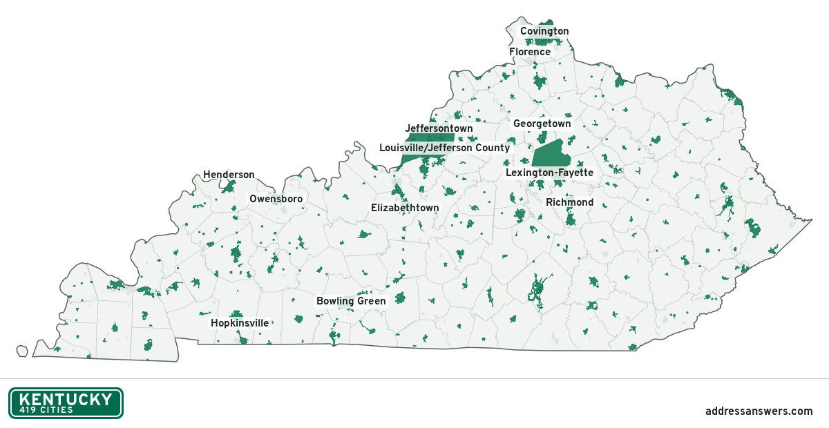
Kentucky city limits map image
The map above as a picture: every Kentucky city and town in green, with county lines. Boundaries from the Census Bureau, as of January 1, 2025.
You’re welcome to use it in a document or on your own site, with a link back to this page.
Download the map (PNG, 1,200 × 620)Questions about Kentucky city limits
How many cities are in Kentucky?
Kentucky has 419 incorporated places: 419 cities, by the Census Bureau’s boundary files for 2025.
What is the largest city in Kentucky?
By population, Louisville/Jefferson County, with about 631,818 residents (2020–2024 American Community Survey 5-year estimates). By land area the largest is Lexington-Fayette, at 283.9 square miles (Louisville/Jefferson County: 262.8).
What is the smallest city in Kentucky?
By the Census Bureau’s estimate, Concord, with 5 residents. Estimates for places this small have a wide margin of error, so treat it as a rough count.
How much of Kentucky is unincorporated?
95% of its land and 2 million of its residents (44%) are outside every city. There, local government is the county. The state also has 136 named unincorporated communities; the largest is Burlington.
Is Burlington, KY a city?
No. Burlington is a census-designated place: a community the Census Bureau maps for statistics, with no city government of its own. About 18,008 people live there, in unincorporated Boone County. An address there is outside city limits, even if its mailing address says otherwise.
Is Fort Campbell North, KY a city?
No. Fort Campbell North is a census-designated place: a community the Census Bureau maps for statistics, with no city government of its own. About 11,356 people live there, in unincorporated Christian County. An address there is outside city limits, even if its mailing address says otherwise.
Which cities in Kentucky are in more than one county?
11 of the 419 cross a county line, by at least 1% of their land. The largest: Corbin (Whitley and Knox), Walton (Boone and Kenton), and Muldraugh (Meade and Hardin). Check an address to see which county it’s in.
Which county in Kentucky has the most cities?
Jefferson County, with 85 at least partly inside it. McCreary County has none.
Bordering states
More answers for a Kentucky address
Each tool checks the same address and puts its own answer first.
- County Census Your county, plus the township or town where those exist. Find your county
- School district Census The public school district that covers the address. Find your school district
- Flood zone FEMA The FEMA zone in plain English, and whether lenders require flood insurance. Check flood zone
- USDA home loans USDA Whether the property is in an area eligible for a USDA Rural Development loan. Check USDA eligibility
- Voting districts Census Your congressional district and your state senate and state house districts. Included in every check
Places, boundaries, land area and counties: US Census Bureau 2025 cartographic boundary files (boundaries as of January 1, 2025). A place is listed in each county that holds at least 1% of its land. Population: 2020–2024 American Community Survey 5-year estimates. Data updated October 24, 2026; page updated October 25, 2026. Boundaries change through annexation; your city or county has the official map.