Tennessee city limits map
Tennessee has 345 incorporated places: 185 cities and 160 towns. They cover 9.9% of the state’s land and are home to 61% of its residents. Everyone else lives outside city limits, where local government is the county. Enter an address to see which side of a city line it’s on.
Result for
The map couldn’t load. The answers don’t depend on it.
The boundary couldn’t load. The answer doesn’t depend on it.
Census Geocoder match
More about this address
Sources and limits
- Census
- US Census Bureau Geocoder, current boundaries
- FEMA
- National Flood Hazard Layer, effective flood maps
- USDA
- Rural Development property eligibility
- Map
- Boundaries from Census TIGERweb, flood zones drawn by FEMA, eligible areas from USDA, base map © OpenStreetMap contributors
Census boundaries are updated once a year, so a recent annexation may not show yet. Informational only, not an official determination. Verify with your city or county.
Tennessee at a glance
- Incorporated places
- 345
- 185 cities and 160 towns
- Residents in city limits
- 61%
- 4,288,811 of 7,066,383
- Land in city limits
- 9.9%
- 4,086 of 41,225 sq mi
- Counties
- 95
- Every one has at least one
- Unincorporated communities
- 159
- Largest: Seymour (16,216)
- Largest city
- Nashville-Davidson
- 690,130 residents
City limits maps for 6 Tennessee cities
Every Tennessee city with 100,000 or more residents has its own page: the boundary in detail, the places around it and its school districts.
All 345 cities and towns in Tennessee
Every incorporated place, largest first, with the counties it’s in and its size. An address inside one of these is inside city limits; anywhere else in the state is unincorporated.
| Name | Type | County | Population | Land (sq mi) |
|---|---|---|---|---|
| Nashville-Davidson | City | Davidson | 690,130 | 475.6 |
| Memphis | City | Shelby | 618,980 | 289.8 |
| Knoxville | City | Knox | 195,185 | 98.7 |
| Chattanooga | City | Hamilton | 185,783 | 142.4 |
| Clarksville | City | Montgomery | 176,456 | 100.1 |
| Murfreesboro | City | Rutherford | 161,445 | 64.8 |
| Franklin | City | Williamson | 87,133 | 44.5 |
| Johnson City | City | Washington, Carter | 72,222 | 43.8 |
| Jackson | City | Madison | 68,435 | 59.2 |
| Hendersonville | City | Sumner | 63,091 | 31.7 |
| Bartlett | City | Shelby | 56,876 | 32.6 |
| Smyrna | Town | Rutherford | 56,692 | 34.5 |
| Kingsport | City | Sullivan, Hawkins | 56,262 | 53.1 |
| Spring Hill | City | Maury, Williamson | 55,765 | 29.7 |
| Collierville | Town | Shelby | 51,515 | 36.7 |
| Cleveland | City | Bradley | 48,829 | 32.0 |
| Gallatin | City | Sumner | 48,532 | 35.7 |
| Brentwood | City | Williamson | 45,556 | 42.2 |
| Columbia | City | Maury | 45,441 | 36.5 |
| Lebanon | City | Wilson | 44,788 | 40.7 |
| Mount Juliet | City | Wilson | 42,073 | 26.9 |
| Germantown | City | Shelby | 40,673 | 20.0 |
| La Vergne | City | Rutherford | 40,243 | 24.7 |
| Cookeville | City | Putnam | 36,088 | 36.0 |
| Oak Ridge | City | Anderson, Roane | 32,693 | 85.2 |
| Maryville | City | Blount | 32,392 | 17.8 |
| Morristown | City | Hamblen, Jefferson | 31,527 | 28.1 |
| Bristol | City | Sullivan | 27,636 | 32.7 |
| Shelbyville | City | Bedford | 24,661 | 19.6 |
| Farragut | Town | Knox | 24,634 | 16.0 |
| East Ridge | City | Hamilton | 22,070 | 8.28 |
| Tullahoma | City | Coffee, Franklin | 21,103 | 23.4 |
| Springfield | City | Robertson | 19,255 | 13.7 |
| Sevierville | City | Sevier | 18,397 | 24.5 |
| Goodlettsville | City | Sumner, Davidson | 17,597 | 14.4 |
| Dickson | City | Dickson | 16,424 | 20.5 |
| Dyersburg | City | Dyer | 15,979 | 17.3 |
| Greeneville | Town | Greene | 15,646 | 17.0 |
| Arlington | Town | Shelby | 15,205 | 23.8 |
| Nolensville | Town | Williamson | 15,074 | 10.5 |
| White House | City | Robertson, Sumner | 14,631 | 11.8 |
| Athens | City | McMinn | 14,471 | 15.6 |
| Elizabethton | City | Carter | 14,374 | 9.58 |
| Lakeland | City | Shelby | 14,192 | 23.5 |
| McMinnville | City | Warren | 13,844 | 11.1 |
| Portland | City | Sumner, Robertson | 13,449 | 15.1 |
| Soddy-Daisy | City | Hamilton | 13,231 | 23.2 |
| Manchester | City | Coffee | 12,944 | 15.3 |
| Lewisburg | City | Marshall | 12,861 | 14.3 |
| Crossville | City | Cumberland | 12,428 | 20.6 |
| Alcoa | City | Blount | 12,222 | 14.9 |
| Red Bank | City | Hamilton | 12,010 | 6.56 |
| Hartsville/Trousdale County | City | Trousdale | 11,957 | 114.3 |
| Lawrenceburg | City | Lawrence | 11,844 | 12.7 |
| Collegedale | City | Hamilton | 11,330 | 12.5 |
| Millington | City | Shelby | 11,289 | 22.4 |
| Lenoir City | City | Loudon | 11,110 | 8.63 |
| Union City | City | Obion | 10,982 | 12.1 |
| Martin | City | Weakley | 10,915 | 12.4 |
| Atoka | Town | Tipton | 10,385 | 12.2 |
| Paris | City | Henry | 10,338 | 12.9 |
| Clinton | City | Anderson | 10,239 | 11.6 |
| Fairview | City | Williamson | 10,009 | 18.0 |
| Oakland | Town | Fayette | 9,979 | 10.5 |
| Winchester | City | Franklin | 9,799 | 11.3 |
| Brownsville | City | Haywood | 9,622 | 9.86 |
| Signal Mountain | Town | Hamilton | 8,860 | 8.37 |
| Covington | City | Tipton | 8,587 | 11.4 |
| Jefferson City | City | Jefferson | 8,579 | 7.01 |
| Thompson's Station | Town | Williamson | 8,294 | 23.9 |
| Pulaski | City | Giles | 8,285 | 7.83 |
| Milan | City | Gibson | 8,244 | 8.94 |
| Lexington | City | Henderson | 7,962 | 11.8 |
| Humboldt | City | Gibson, Madison | 7,787 | 10.4 |
| Ripley | City | Lauderdale | 7,658 | 13.4 |
| Dayton | City | Rhea | 7,625 | 8.50 |
| Savannah | City | Hardin | 7,412 | 6.82 |
| La Follette | City | Campbell | 7,273 | 4.91 |
| Church Hill | City | Hawkins | 7,139 | 9.43 |
| Fayetteville | City | Lincoln | 7,057 | 9.09 |
| Greenbrier | Town | Robertson | 6,971 | 7.26 |
| Newport | City | Cocke | 6,881 | 5.54 |
| Lynchburg, Moore County | City | Moore | 6,674 | 129.2 |
| Munford | City | Tipton | 6,588 | 9.48 |
| Sweetwater | City | Monroe, McMinn | 6,532 | 8.97 |
| Loudon | City | Loudon | 6,432 | 12.7 |
| Henderson | City | Chester | 6,411 | 7.81 |
| Pigeon Forge | City | Sevier | 6,375 | 13.8 |
| Jonesborough | Town | Washington | 6,232 | 5.46 |
| Kingston | City | Roane | 6,224 | 7.29 |
| Harriman | City | Roane | 6,090 | 10.6 |
| Erwin | Town | Unicoi | 5,988 | 4.13 |
| Millersville | City | Sumner, Robertson | 5,836 | 13.8 |
| Lafayette | City | Macon | 5,727 | 5.33 |
| Dunlap | City | Sequatchie | 5,678 | 10.8 |
| McKenzie | City | Carroll, Henry +1 | 5,631 | 6.37 |
| Rockwood | City | Roane | 5,566 | 8.02 |
| Mount Carmel | Town | Hawkins | 5,472 | 6.64 |
| Ashland City | Town | Cheatham | 5,424 | 10.7 |
| Medina | City | Gibson | 5,407 | 4.10 |
| Smithville | City | DeKalb | 5,288 | 5.89 |
| Pleasant View | City | Cheatham | 5,276 | 12.5 |
| Madisonville | City | Monroe | 5,241 | 6.00 |
| Bolivar | City | Hardeman | 5,144 | 8.11 |
| Sparta | City | White | 4,939 | 6.72 |
| Mount Pleasant | City | Maury | 4,837 | 12.6 |
| Forest Hills | City | Davidson | 4,683 | 9.24 |
| Rogersville | Town | Hawkins | 4,647 | 3.76 |
| Coopertown | Town | Robertson | 4,640 | 31.6 |
| Oak Hill | City | Davidson | 4,617 | 7.84 |
| Whiteville | Town | Hardeman | 4,530 | 2.64 |
| Selmer | Town | McNairy | 4,488 | 9.55 |
| Huntingdon | Town | Carroll | 4,441 | 11.8 |
| Louisville | City | Blount | 4,383 | 14.9 |
| Harrogate | City | Claiborne | 4,368 | 7.26 |
| Waverly | City | Humphreys | 4,302 | 8.75 |
| Trenton | City | Gibson | 4,151 | 8.04 |
| White Bluff | Town | Dickson | 4,080 | 6.39 |
| Algood | City | Putnam | 4,036 | 4.09 |
| Livingston | Town | Overton | 3,999 | 6.51 |
| Hohenwald | City | Lewis | 3,884 | 5.27 |
| Oneida | Town | Scott | 3,819 | 9.39 |
| Unicoi | Town | Unicoi | 3,806 | 16.2 |
| Camden | City | Benton | 3,678 | 5.68 |
| Gatlinburg | City | Sevier | 3,663 | 10.4 |
| Etowah | City | McMinn | 3,658 | 2.83 |
| Jasper | Town | Marion | 3,612 | 9.85 |
| Tiptonville | Town | Lake | 3,572 | 3.32 |
| Dandridge | Town | Jefferson | 3,538 | 6.10 |
| Centerville | Town | Hickman | 3,535 | 10.8 |
| Somerville | Town | Fayette | 3,466 | 13.6 |
| Tusculum | City | Greene | 3,337 | 4.86 |
| Newbern | Town | Dyer | 3,289 | 4.53 |
| Oliver Springs | Town | Anderson, Roane +1 | 3,281 | 5.77 |
| Blaine | City | Grainger | 3,213 | 9.52 |
| Bean Station | City | Grainger | 3,016 | 5.92 |
| South Pittsburg | City | Marion | 3,013 | 8.22 |
| Decherd | City | Franklin | 2,976 | 4.82 |
| Dresden | Town | Weakley | 2,943 | 5.94 |
| Tazewell | Town | Claiborne | 2,902 | 4.34 |
| Brighton | Town | Tipton | 2,889 | 3.23 |
| Westmoreland | Town | Sumner | 2,845 | 4.71 |
| New Tazewell | Town | Claiborne | 2,799 | 5.07 |
| Kingston Springs | Town | Cheatham | 2,791 | 10.1 |
| Woodbury | Town | Cannon | 2,774 | 1.98 |
| Monterey | Town | Putnam | 2,768 | 3.03 |
| Belle Meade | City | Davidson | 2,708 | 3.07 |
| Estill Springs | Town | Franklin | 2,695 | 4.84 |
| Parsons | City | Decatur | 2,686 | 4.05 |
| Clifton | City | Wayne | 2,660 | 5.56 |
| Jacksboro | Town | Campbell | 2,650 | 2.58 |
| Piperton | City | Fayette | 2,569 | 27.2 |
| White Pine | Town | Jefferson | 2,565 | 2.87 |
| Mountain City | Town | Johnson | 2,542 | 3.37 |
| Maynardville | City | Union | 2,528 | 5.39 |
| Mosheim | Town | Greene | 2,511 | 6.39 |
| Plainview | City | Union | 2,458 | 6.37 |
| South Fulton | City | Obion | 2,379 | 3.38 |
| Bells | City | Crockett | 2,373 | 2.37 |
| South Carthage | Town | Smith | 2,364 | 2.56 |
| Spring City | Town | Rhea | 2,358 | 2.77 |
| Carthage | Town | Smith | 2,327 | 2.90 |
| Pikeville | City | Bledsoe | 2,319 | 2.44 |
| Alamo | Town | Crockett | 2,311 | 2.20 |
| Waynesboro | City | Wayne | 2,296 | 4.28 |
| Adamsville | Town | McNairy, Hardin | 2,278 | 4.67 |
| Greenfield | City | Weakley | 2,264 | 3.48 |
| Jamestown | City | Fentress | 2,230 | 3.12 |
| Bluff City | City | Sullivan | 2,225 | 1.75 |
| Dyer | City | Gibson | 2,217 | 2.86 |
| Vonore | Town | Monroe | 2,191 | 8.81 |
| Lakesite | City | Hamilton | 2,168 | 1.74 |
| Charlotte | Town | Dickson | 2,164 | 4.06 |
| Lookout Mountain | Town | Hamilton | 2,111 | 1.34 |
| Pegram | Town | Cheatham | 2,089 | 7.25 |
| Caryville | Town | Campbell | 2,073 | 5.56 |
| New Johnsonville | City | Humphreys | 2,060 | 5.15 |
| Whitwell | City | Marion | 2,052 | 3.51 |
| Halls | Town | Lauderdale | 2,034 | 3.68 |
| Three Way | City | Madison | 2,008 | 4.49 |
| Ridgetop | City | Robertson, Davidson | 1,995 | 3.03 |
| Berry Hill | City | Davidson | 1,980 | 0.91 |
| Dover | City | Stewart | 1,956 | 3.87 |
| Celina | City | Clay | 1,941 | 1.84 |
| Cowan | City | Franklin | 1,934 | 2.11 |
| Monteagle | Town | Grundy, Marion +1 | 1,926 | 9.04 |
| Cross Plains | City | Robertson | 1,922 | 8.69 |
| Surgoinsville | Town | Hawkins | 1,911 | 5.73 |
| Decatur | Town | Meigs | 1,898 | 3.80 |
| Burns | Town | Dickson | 1,884 | 3.53 |
| Jellico | City | Campbell | 1,855 | 6.22 |
| Cornersville | Town | Marshall | 1,847 | 5.85 |
| Walden | Town | Hamilton | 1,845 | 3.53 |
| Troy | Town | Obion | 1,827 | 1.35 |
| Englewood | Town | McMinn | 1,818 | 1.91 |
| Huntsville | Town | Scott | 1,814 | 8.30 |
| McEwen | City | Humphreys | 1,806 | 1.84 |
| Ridgely | Town | Lake | 1,796 | 1.98 |
| Loretto | City | Lawrence | 1,731 | 3.78 |
| Tennessee Ridge | Town | Houston | 1,726 | 3.75 |
| Chapel Hill | Town | Marshall | 1,712 | 3.84 |
| Tracy City | Town | Grundy | 1,682 | 4.66 |
| Rutledge | Town | Grainger | 1,676 | 5.53 |
| Kimball | Town | Marion | 1,639 | 5.31 |
| New Market | Town | Jefferson | 1,619 | 4.23 |
| Rocky Top | City | Anderson, Campbell | 1,607 | 1.62 |
| Benton | Town | Polk | 1,560 | 3.03 |
| Huntland | Town | Franklin | 1,532 | 1.52 |
| Kenton | Town | Gibson, Obion | 1,513 | 2.52 |
| Spencer | City | Van Buren | 1,511 | 6.55 |
| Powells Crossroads | Town | Marion | 1,498 | 4.90 |
| Norris | City | Anderson | 1,485 | 8.33 |
| Gruetli-Laager | City | Grundy | 1,480 | 12.7 |
| Watertown | City | Wilson | 1,463 | 1.44 |
| Bruceton | Town | Carroll | 1,431 | 1.68 |
| Bradford | Town | Gibson | 1,385 | 1.77 |
| Greenback | City | Loudon | 1,378 | 8.31 |
| Sneedville | Town | Hancock | 1,364 | 2.30 |
| Baxter | Town | Putnam | 1,361 | 3.14 |
| Altamont | Town | Grundy | 1,322 | 19.8 |
| Graysville | Town | Rhea | 1,304 | 1.18 |
| Gordonsville | Town | Smith | 1,299 | 7.11 |
| Red Boiling Springs | City | Macon | 1,262 | 1.75 |
| Crump | City | Hardin | 1,231 | 5.08 |
| Orlinda | City | Robertson | 1,214 | 6.59 |
| Wartburg | City | Morgan | 1,191 | 1.13 |
| Gleason | Town | Weakley | 1,159 | 2.23 |
| Luttrell | Town | Union | 1,158 | 3.93 |
| Winfield | Town | Scott | 1,153 | 6.79 |
| Tellico Plains | Town | Monroe | 1,146 | 1.95 |
| Rossville | Town | Fayette | 1,142 | 6.39 |
| Byrdstown | Town | Pickett | 1,141 | 1.49 |
| Alexandria | Town | DeKalb | 1,136 | 1.21 |
| Linden | Town | Perry | 1,122 | 1.00 |
| Rutherford | Town | Gibson | 1,119 | 2.30 |
| Atwood | Town | Carroll | 1,108 | 1.73 |
| Obion | Town | Obion | 1,087 | 1.29 |
| Scotts Hill | Town | Henderson, Decatur | 1,083 | 3.67 |
| Allardt | City | Fentress | 1,076 | 3.77 |
| Ardmore | City | Giles, Lincoln | 1,073 | 4.70 |
| Gainesboro | Town | Jackson | 1,064 | 1.56 |
| Erin | City | Houston | 1,058 | 3.90 |
| Mason | Town | Tipton | 1,039 | 1.98 |
| Sharon | Town | Weakley | 1,036 | 1.27 |
| Lobelville | City | Perry | 1,007 | 3.75 |
| Eagleville | City | Rutherford | 999 | 3.29 |
| Collinwood | City | Wayne | 996 | 2.78 |
| Crab Orchard | City | Cumberland | 980 | 10.9 |
| Friendsville | City | Blount | 980 | 2.84 |
| Trezevant | Town | Carroll | 980 | 1.42 |
| Henning | Town | Lauderdale | 977 | 2.47 |
| Charleston | City | Bradley | 956 | 1.15 |
| Bulls Gap | Town | Hawkins | 948 | 1.22 |
| Decaturville | Town | Decatur | 934 | 1.65 |
| Coalmont | City | Grundy | 906 | 6.06 |
| Clarksburg | Town | Carroll | 895 | 2.49 |
| Adams | City | Robertson | 888 | 2.39 |
| Ridgeside | City | Hamilton | 879 | 0.17 |
| New Hope | City | Marion | 862 | 10.3 |
| Morrison | Town | Warren | 850 | 2.99 |
| Rockford | City | Blount | 824 | 3.40 |
| Palmer | Town | Grundy | 818 | 4.93 |
| Sunbright | City | Morgan | 792 | 3.53 |
| St. Joseph | City | Lawrence | 783 | 3.77 |
| Moscow | City | Fayette | 768 | 1.28 |
| Eastview | Town | McNairy | 767 | 5.12 |
| Saltillo | Town | Hardin | 753 | 3.07 |
| Middleton | City | Hardeman | 743 | 2.09 |
| Hollow Rock | Town | Carroll | 739 | 1.69 |
| Puryear | City | Henry | 736 | 0.95 |
| Niota | City | McMinn | 735 | 2.30 |
| Minor Hill | City | Giles | 704 | 1.86 |
| Stanton | Town | Haywood | 704 | 0.52 |
| Townsend | City | Blount | 701 | 1.99 |
| Baneberry | City | Jefferson | 700 | 1.78 |
| Friendship | City | Crockett | 692 | 1.32 |
| Philadelphia | City | Loudon | 684 | 1.56 |
| Maury City | Town | Crockett | 683 | 1.13 |
| Finger | City | McNairy | 669 | 1.57 |
| Vanleer | Town | Dickson | 666 | 2.20 |
| Bethel Springs | Town | McNairy | 664 | 2.23 |
| Beersheba Springs | Town | Grundy | 654 | 4.80 |
| Watauga | City | Carter, Washington | 644 | 0.87 |
| Wartrace | Town | Bedford | 630 | 0.88 |
| Woodland Mills | City | Obion | 624 | 1.27 |
| Gates | Town | Lauderdale | 619 | 0.71 |
| Parker's Crossroads | City | Henderson | 615 | 3.79 |
| Gallaway | City | Fayette | 609 | 5.81 |
| Pittman Center | Town | Sevier | 583 | 6.01 |
| Cumberland City | Town | Stewart | 574 | 5.01 |
| Michie | Town | McNairy | 558 | 5.62 |
| Trimble | Town | Dyer, Obion | 554 | 0.65 |
| Baileyton | Town | Greene | 551 | 1.62 |
| Calhoun | Town | McMinn | 546 | 1.19 |
| Hornbeak | Town | Obion | 540 | 1.05 |
| Sardis | Town | Henderson | 536 | 2.50 |
| Henry | Town | Henry | 534 | 1.28 |
| Doyle | Town | White | 532 | 1.24 |
| Bell Buckle | Town | Bedford | 529 | 0.51 |
| Gilt Edge | City | Tipton | 516 | 2.71 |
| Pleasant Hill | Town | Cumberland | 514 | 1.63 |
| Petersburg | Town | Lincoln, Marshall | 508 | 1.01 |
| Big Sandy | Town | Benton | 507 | 0.63 |
| Copperhill | City | Polk | 493 | 1.77 |
| Williston | City | Fayette | 480 | 1.65 |
| Gibson | Town | Gibson | 479 | 0.61 |
| Elkton | City | Giles | 469 | 1.99 |
| Lynnville | Town | Giles | 465 | 0.34 |
| Gadsden | Town | Crockett | 459 | 1.12 |
| Ducktown | City | Polk | 456 | 2.64 |
| Grand Junction | City | Hardeman, Fayette | 435 | 1.19 |
| Dowelltown | Town | DeKalb | 434 | 0.75 |
| Guys | Town | McNairy | 423 | 11.4 |
| Ethridge | Town | Lawrence | 419 | 1.15 |
| Liberty | Town | DeKalb | 406 | 1.15 |
| Burlison | Town | Tipton | 398 | 1.05 |
| Cedar Hill | City | Robertson | 395 | 0.62 |
| McLemoresville | Town | Carroll | 391 | 2.21 |
| Parrottsville | Town | Cocke | 374 | 0.74 |
| Garland | Town | Tipton | 370 | 0.54 |
| Auburntown | Town | Cannon | 318 | 0.58 |
| Stantonville | Town | McNairy | 313 | 1.13 |
| Cumberland Gap | Town | Claiborne | 309 | 0.33 |
| Braden | Town | Fayette | 308 | 3.67 |
| Yorkville | City | Gibson | 307 | 1.30 |
| Saulsbury | Town | Hardeman | 304 | 0.61 |
| Milledgeville | Town | Chester, Hardin +1 | 299 | 1.61 |
| Toone | Town | Hardeman | 289 | 1.05 |
| Centertown | Town | Warren | 263 | 0.92 |
| Ramer | City | McNairy | 243 | 1.79 |
| Samburg | Town | Obion | 231 | 0.47 |
| Hornsby | Town | Hardeman | 228 | 1.05 |
| Medon | City | Madison | 201 | 0.99 |
| Slayden | Town | Dickson | 189 | 1.53 |
| Mitchellville | City | Sumner | 176 | 0.54 |
| Oakdale | Town | Morgan | 175 | 0.87 |
| Enville | Town | Chester | 163 | 1.44 |
| Rives | Town | Obion | 162 | 0.35 |
| Viola | Town | Warren | 144 | 0.49 |
| Hickory Valley | Town | Hardeman | 126 | 0.32 |
| Normandy | Town | Bedford | 106 | 0.26 |
| Silerton | Town | Hardeman, Chester | 81 | 0.67 |
| Orme | Town | Marion | 76 | 4.13 |
| La Grange | Town | Fayette | 62 | 2.01 |
| Cottage Grove | Town | Henry | 60 | 0.17 |
Showing 1–50 of 345
Unincorporated communities in Tennessee
Census-designated places: named communities the Census Bureau maps for statistics, with no city government of their own. An address in one is outside city limits, even when its mailing address names a city. Tennessee has 159.
| Community | County | Population | Land (sq mi) |
|---|---|---|---|
| Seymour | Sevier | 16,216 | 16.0 |
| Powell | Knox | 13,739 | 8.54 |
| Middle Valley | Hamilton | 12,187 | 9.77 |
| Halls | Knox | 10,272 | 8.83 |
| Fairfield Glade | Cumberland | 9,487 | 23.0 |
| Bloomingdale | Sullivan | 9,292 | 9.77 |
| Harrison | Hamilton | 8,011 | 6.74 |
| South Cleveland | Bradley | 7,452 | 14.0 |
| Tellico Village | Loudon | 7,414 | 7.46 |
| Green Hill | Wilson | 6,866 | 3.48 |
| Eagleton Village | Blount | 5,598 | 3.02 |
| Christiana | Rutherford | 4,777 | 8.86 |
| Oak Grove | Washington | 4,626 | 4.53 |
| Lake Tansi | Cumberland | 4,437 | 8.83 |
| Shackle Island | Sumner | 4,404 | 5.54 |
| Apison | Hamilton | 4,271 | 16.2 |
| Karns | Knox | 4,115 | 2.99 |
| Spurgeon | Washington | 4,071 | 4.09 |
| Wildwood Lake | Bradley | 3,495 | 12.0 |
| Blountville | Sullivan | 3,309 | 4.93 |
| Mascot | Knox | 3,277 | 6.96 |
| Colonial Heights | Sullivan | 3,258 | 3.82 |
| Sale Creek | Hamilton | 2,955 | 30.1 |
| Sewanee | Franklin | 2,936 | 3.89 |
| Park City | Lincoln | 2,813 | 5.46 |
| Coalfield | Morgan | 2,754 | 24.7 |
| Strawberry Plains | Jefferson | 2,669 | 4.19 |
| Hopewell | Bradley | 2,634 | 7.12 |
| Walnut Hill | Sullivan | 2,415 | 4.10 |
| Falling Water | Hamilton | 2,315 | 5.01 |
| Gray | Washington | 2,237 | 1.49 |
| Gladeville | Wilson | 2,199 | 4.53 |
| New Union | Coffee | 2,160 | 3.84 |
| Valley Forge | Carter | 2,136 | 3.16 |
| Fairmount | Hamilton | 2,110 | 4.19 |
| Rural Hill | Wilson | 2,075 | 4.06 |
| Pine Crest | Carter | 2,029 | 1.93 |
| Central | Carter | 1,938 | 3.52 |
| East Cleveland | Bradley | 1,934 | 1.23 |
| Hunter | Carter | 1,918 | 6.40 |
| Hampton | Carter | 1,883 | 4.36 |
| Biltmore | Carter | 1,846 | 2.57 |
| Mowbray Mountain | Hamilton | 1,721 | 20.2 |
| Rockvale | Rutherford | 1,611 | 4.23 |
| Bon Aqua Junction | Hickman | 1,586 | 4.71 |
| Dodson Branch | Jackson | 1,425 | 11.1 |
| Lone Oak | Sequatchie | 1,422 | 6.47 |
| Lyles | Hickman | 1,385 | 2.62 |
| Olivet | Hardin | 1,377 | 5.96 |
| Fincastle | Campbell | 1,374 | 3.65 |
| Midtown | Roane | 1,369 | 4.49 |
| Unionville | Bedford | 1,275 | 9.03 |
| Sullivan Gardens | Sullivan | 1,267 | 2.50 |
| Banner Hill | Unicoi | 1,211 | 1.40 |
| John Sevier | Knox | 1,177 | 0.76 |
| Grimsley | Fentress | 1,171 | 10.9 |
| Fall Branch | Washington | 1,160 | 4.52 |
| Lakewood Park | Coffee | 1,140 | 5.74 |
| Embreeville | Washington | 1,062 | 1.34 |
| Flat Top Mountain | Hamilton | 1,004 | 17.3 |
| Wildwood | Blount | 968 | 2.49 |
| Kahite | Monroe | 892 | 1.30 |
| Delano | Polk | 838 | 3.83 |
| Riceville | McMinn | 823 | 2.18 |
| Orebank | Sullivan | 816 | 0.88 |
| Roan Mountain | Carter | 797 | 6.63 |
| Cosby | Cocke | 779 | 5.53 |
| Rarity Bay | Loudon | 757 | 1.82 |
| Mooresburg | Hawkins | 755 | 3.79 |
| Fowlkes | Dyer | 753 | 2.09 |
| Summertown | Lawrence | 733 | 2.01 |
| Telford | Washington | 731 | 2.47 |
| McDonald | Bradley | 712 | 1.46 |
| Pelham | Grundy | 704 | 16.6 |
| Russellville | Hamblen | 684 | 1.04 |
| Castalian Springs | Sumner | 678 | 5.82 |
| Griffith Creek | Marion | 586 | 3.09 |
| Darden | Henderson | 582 | 8.39 |
| Ooltewah | Hamilton | 578 | 0.62 |
| Walnut Grove | Sumner | 575 | 4.82 |
| Pinson | Madison | 565 | 4.06 |
| Hillsboro | Coffee | 555 | 4.12 |
| Clarkrange | Fentress | 554 | 10.2 |
| Flintville | Lincoln | 525 | 5.32 |
| Finley | Dyer | 481 | 1.30 |
| Beech Bluff | Madison | 437 | 4.40 |
| Tuckers Crossroads | Wilson | 426 | 2.85 |
| Bowman | Cumberland | 422 | 2.29 |
| Walnut Grove | Hardin | 403 | 5.76 |
| Pocahontas | Hardeman | 391 | 2.05 |
| Walland | Blount | 377 | 1.52 |
| Cottontown | Sumner | 374 | 3.51 |
| Leoma | Lawrence | 374 | 1.90 |
| Mayland | Cumberland | 365 | 1.62 |
| Sequatchie | Marion | 359 | 1.03 |
| Chesterfield | Henderson | 356 | 7.68 |
| Andersonville | Anderson | 353 | 1.62 |
| Petros | Morgan | 352 | 3.94 |
| Fairfield | Sumner | 351 | 0.99 |
| Lenox | Dyer | 348 | 2.52 |
| Elgin | Scott | 347 | 1.94 |
| Nixon | Hardin | 294 | 1.76 |
| Bethpage | Sumner | 289 | 1.33 |
| Graball | Sumner | 288 | 2.01 |
| Iron City | Lawrence | 282 | 0.69 |
| Counce | Hardin | 276 | 1.51 |
| Hickman | Smith | 276 | 1.52 |
| Hilham | Overton | 267 | 3.53 |
| Fairgarden | Sevier | 262 | 1.73 |
| Randolph | Tipton | 252 | 1.45 |
| Taft | Lincoln | 251 | 3.59 |
| Oak Grove | Sumner | 248 | 1.28 |
| New Deal | Sumner | 226 | 1.89 |
| Morris Chapel | Hardin | 218 | 2.62 |
| Ocoee | Polk | 208 | 0.93 |
| Bon Air | White | 205 | 1.97 |
| Statesville | Wilson | 201 | 0.88 |
| Farner | Polk | 197 | 1.46 |
| Briceville | Anderson | 175 | 0.48 |
| Big Rock | Stewart | 163 | 1.72 |
| Greenvale | Wilson | 161 | 2.42 |
| Blanche | Lincoln | 156 | 5.88 |
| Coker Creek | Monroe | 155 | 1.92 |
| Essary Springs | Hardeman | 154 | 4.13 |
| Chewalla | McNairy | 150 | 1.34 |
| Prospect | Giles | 145 | 1.39 |
| Westpoint | Lawrence | 139 | 0.90 |
| Norene | Wilson | 137 | 1.71 |
| Robbins | Scott | 133 | 1.75 |
| Holladay | Benton | 130 | 1.48 |
| Shiloh | Hardin | 130 | 1.50 |
| Conasauga | Polk | 128 | 0.38 |
| Mercer | Madison | 128 | 1.74 |
| Butler | Johnson | 127 | 0.76 |
| Palmersville | Weakley | 114 | 2.88 |
| Walterhill | Rutherford | 113 | 3.01 |
| Eva | Benton | 109 | 1.99 |
| Buchanan | Henry | 105 | 1.05 |
| Helenwood | Scott | 101 | 2.01 |
| Miston | Dyer | 96 | 1.39 |
| Dukedom | Weakley | 92 | 1.87 |
| Dellrose | Lincoln | 86 | 2.26 |
| Belvidere | Franklin | 82 | 0.48 |
| Lavinia | Carroll | 82 | 1.41 |
| Wildersville | Henderson | 78 | 1.68 |
| Luray | Henderson | 77 | 3.27 |
| Bogota | Dyer | 67 | 2.42 |
| Yuma | Carroll | 54 | 1.45 |
| Dancyville | Haywood | 53 | 1.45 |
| Wrigley | Hickman | 50 | 0.96 |
| Sherwood | Franklin | 43 | 0.91 |
| Whiteside | Marion | 33 | 3.96 |
| Jacks Creek | Chester | 28 | 0.99 |
| Frankewing | Giles | 19 | 0.94 |
| Childers Hill | Hardin | 18 | 1.21 |
| Whitlock | Henry | 18 | 0.76 |
| Wynnburg | Lake | 16 | 1.16 |
| Bransford | Sumner | 0 | 4.03 |
| Huron | Henderson | 0 | 0.99 |
Showing 1–50 of 159
Counties in Tennessee
95 counties, with how many cities and towns have land in each and the largest whose main county it is.
| County | Cities | Largest | Population | Land (sq mi) |
|---|---|---|---|---|
| Shelby County | 7 | Memphis | 919,173 | 752.8 |
| Davidson County | 7 | Nashville-Davidson | 715,388 | 503.5 |
| Knox County | 2 | Knoxville | 494,148 | 508.3 |
| Hamilton County | 10 | Chattanooga | 376,192 | 542.2 |
| Rutherford County | 4 | Murfreesboro | 360,646 | 619.5 |
| Williamson County | 6 | Franklin | 260,351 | 582.9 |
| Montgomery County | 1 | Clarksville | 234,153 | 539.2 |
| Sumner County | 8 | Hendersonville | 204,424 | 529.5 |
| Sullivan County | 3 | Kingsport | 160,624 | 413.5 |
| Wilson County | 3 | Lebanon | 158,805 | 571.1 |
| Blount County | 6 | Maryville | 139,333 | 558.8 |
| Washington County | 3 | Johnson City | 136,261 | 326.5 |
| Bradley County | 2 | Cleveland | 111,065 | 328.8 |
| Maury County | 3 | Spring Hill | 107,791 | 613.1 |
| Sevier County | 4 | Sevierville | 99,652 | 592.5 |
| Madison County | 4 | Jackson | 99,295 | 557.2 |
| Putnam County | 4 | Cookeville | 82,558 | 401.1 |
| Anderson County | 5 | Oak Ridge | 79,153 | 337.2 |
| Robertson County | 11 | Springfield | 75,539 | 476.3 |
| Greene County | 4 | Greeneville | 71,628 | 622.2 |
| Hamblen County | 1 | Morristown | 65,669 | 161.2 |
| Cumberland County | 3 | Crossville | 63,553 | 681.3 |
| Tipton County | 8 | Atoka | 61,553 | 455.6 |
| Coffee County | 2 | Tullahoma | 59,710 | 429.0 |
| Loudon County | 4 | Lenoir City | 58,580 | 229.3 |
| Hawkins County | 6 | Church Hill | 57,964 | 487.1 |
| Jefferson County | 6 | Jefferson City | 56,864 | 275.2 |
| Carter County | 3 | Elizabethton | 56,712 | 341.3 |
| Dickson County | 6 | Dickson | 55,983 | 489.9 |
| Roane County | 5 | Kingston | 55,208 | 360.8 |
| McMinn County | 6 | Athens | 54,884 | 430.1 |
| Bedford County | 4 | Shelbyville | 52,237 | 473.6 |
| Gibson County | 10 | Milan | 50,869 | 602.7 |
| Monroe County | 4 | Sweetwater | 47,695 | 635.8 |
| Lawrence County | 4 | Lawrenceburg | 45,385 | 617.1 |
| Franklin County | 7 | Winchester | 43,990 | 554.5 |
| Fayette County | 10 | Oakland | 43,267 | 704.1 |
| Warren County | 4 | McMinnville | 42,166 | 432.7 |
| Cheatham County | 4 | Ashland City | 41,829 | 302.5 |
| Campbell County | 5 | La Follette | 39,761 | 480.2 |
| Cocke County | 2 | Newport | 36,813 | 436.1 |
| Dyer County | 3 | Dyersburg | 36,508 | 512.4 |
| Marshall County | 4 | Lewisburg | 36,049 | 375.5 |
| Lincoln County | 3 | Fayetteville | 35,946 | 570.3 |
| Rhea County | 3 | Dayton | 33,992 | 315.5 |
| Weakley County | 6 | Martin | 33,016 | 580.4 |
| Claiborne County | 4 | Harrogate | 32,466 | 434.6 |
| Henry County | 5 | Paris | 32,412 | 561.9 |
| Giles County | 5 | Pulaski | 30,620 | 610.9 |
| Obion County | 10 | Union City | 30,453 | 544.9 |
| Marion County | 8 | Jasper | 29,250 | 498.3 |
| Carroll County | 8 | McKenzie | 28,641 | 597.7 |
| White County | 2 | Sparta | 28,160 | 376.7 |
| Henderson County | 4 | Lexington | 27,980 | 520.0 |
| Hardin County | 5 | Savannah | 27,249 | 577.5 |
| Macon County | 2 | Lafayette | 26,240 | 307.1 |
| McNairy County | 10 | Selmer | 25,970 | 562.8 |
| Hickman County | 1 | Centerville | 25,436 | 612.5 |
| Hardeman County | 9 | Bolivar | 25,433 | 667.8 |
| Lauderdale County | 4 | Ripley | 24,784 | 471.9 |
| Grainger County | 3 | Blaine | 24,266 | 280.6 |
| Overton County | 1 | Livingston | 23,065 | 433.5 |
| Scott County | 3 | Oneida | 22,113 | 532.3 |
| Morgan County | 4 | Wartburg | 21,361 | 522.2 |
| DeKalb County | 4 | Smithville | 20,959 | 304.4 |
| Union County | 3 | Maynardville | 20,431 | 223.6 |
| Smith County | 3 | South Carthage | 20,389 | 314.3 |
| Fentress County | 2 | Jamestown | 19,309 | 498.6 |
| Humphreys County | 3 | Waverly | 19,214 | 530.8 |
| Johnson County | 1 | Mountain City | 18,196 | 298.4 |
| Polk County | 3 | Benton | 17,898 | 434.6 |
| Unicoi County | 2 | Erwin | 17,756 | 186.1 |
| Chester County | 4 | Henderson | 17,611 | 285.7 |
| Haywood County | 2 | Brownsville | 17,475 | 533.1 |
| Sequatchie County | 1 | Dunlap | 16,809 | 265.9 |
| Wayne County | 3 | Clifton | 16,168 | 734.1 |
| Benton County | 2 | Camden | 16,006 | 394.3 |
| Bledsoe County | 1 | Pikeville | 15,032 | 406.6 |
| Cannon County | 2 | Woodbury | 14,818 | 265.6 |
| Stewart County | 2 | Dover | 14,027 | 459.8 |
| Crockett County | 5 | Bells | 13,944 | 265.5 |
| Grundy County | 7 | Monteagle | 13,819 | 360.4 |
| Meigs County | 1 | Decatur | 13,343 | 195.1 |
| Lewis County | 1 | Hohenwald | 12,992 | 282.1 |
| Jackson County | 1 | Gainesboro | 12,029 | 308.8 |
| Trousdale County | 1 | Hartsville/Trousdale County | 11,957 | 114.3 |
| Decatur County | 3 | Parsons | 11,579 | 333.9 |
| Perry County | 2 | Linden | 8,697 | 414.8 |
| Houston County | 2 | Tennessee Ridge | 8,353 | 200.3 |
| Clay County | 1 | Celina | 7,670 | 236.5 |
| Hancock County | 1 | Sneedville | 6,852 | 222.3 |
| Moore County | 1 | Lynchburg, Moore County | 6,674 | 129.2 |
| Lake County | 2 | Tiptonville | 6,579 | 165.8 |
| Van Buren County | 1 | Spencer | 6,437 | 273.4 |
| Pickett County | 1 | Byrdstown | 5,079 | 163.0 |
Showing 1–50 of 95
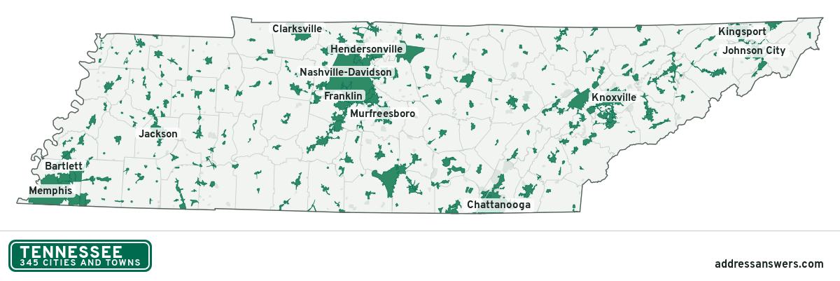
Tennessee city limits map image
The map above as a picture: every Tennessee city and town in green, with county lines. Boundaries from the Census Bureau, as of January 1, 2025.
You’re welcome to use it in a document or on your own site, with a link back to this page.
Download the map (PNG, 1,200 × 401)Questions about Tennessee city limits
How many cities and towns are in Tennessee?
Tennessee has 345 incorporated places: 185 cities and 160 towns, by the Census Bureau’s boundary files for 2025.
What is the largest city in Tennessee?
By population, Nashville-Davidson, with about 690,130 residents (2020–2024 American Community Survey 5-year estimates). It is also the largest by land area, at 475.6 square miles.
What is the smallest town in Tennessee?
By the Census Bureau’s estimate, Cottage Grove, with 60 residents. Estimates for places this small have a wide margin of error, so treat it as a rough count.
How much of Tennessee is unincorporated?
90% of its land and 2.8 million of its residents (39%) are outside every city or town. There, local government is the county. The state also has 159 named unincorporated communities; the largest is Seymour.
Is Seymour, TN a city?
No. Seymour is a census-designated place: a community the Census Bureau maps for statistics, with no city government of its own. About 16,216 people live there, in unincorporated Sevier County. An address there is outside city limits, even if its mailing address says otherwise.
Is Powell, TN a city?
No. Powell is a census-designated place: a community the Census Bureau maps for statistics, with no city government of its own. About 13,739 people live there, in unincorporated Knox County. An address there is outside city limits, even if its mailing address says otherwise.
Which cities and towns in Tennessee are in more than one county?
27 of the 345 cross a county line, by at least 1% of their land. The largest: Johnson City (Washington and Carter), Kingsport (Sullivan and Hawkins), and Spring Hill (Maury and Williamson). Check an address to see which county it’s in.
Which county in Tennessee has the most cities and towns?
Robertson County, with 11 at least partly inside it. Every county in Tennessee has at least one.
Bordering states
More answers for a Tennessee address
Each tool checks the same address and puts its own answer first.
- County Census Your county, plus the township or town where those exist. Find your county
- School district Census The public school district that covers the address. Find your school district
- Flood zone FEMA The FEMA zone in plain English, and whether lenders require flood insurance. Check flood zone
- USDA home loans USDA Whether the property is in an area eligible for a USDA Rural Development loan. Check USDA eligibility
- Voting districts Census Your congressional district and your state senate and state house districts. Included in every check
Places, boundaries, land area and counties: US Census Bureau 2025 cartographic boundary files (boundaries as of January 1, 2025). A place is listed in each county that holds at least 1% of its land. Population: 2020–2024 American Community Survey 5-year estimates. Data updated October 24, 2026; page updated October 25, 2026. Boundaries change through annexation; your city or county has the official map.