Virginia city limits map
Virginia has 227 incorporated places: 38 cities and 189 towns. They cover 5.5% of the state’s land and are home to 36% of its residents. Everyone else lives outside city limits, where local government is the county. Enter an address to see which side of a city line it’s on.
Result for
The map couldn’t load. The answers don’t depend on it.
The boundary couldn’t load. The answer doesn’t depend on it.
Census Geocoder match
More about this address
Sources and limits
- Census
- US Census Bureau Geocoder, current boundaries
- FEMA
- National Flood Hazard Layer, effective flood maps
- USDA
- Rural Development property eligibility
- Map
- Boundaries from Census TIGERweb, flood zones drawn by FEMA, eligible areas from USDA, base map © OpenStreetMap contributors
Census boundaries are updated once a year, so a recent annexation may not show yet. Informational only, not an official determination. Verify with your city or county.
Virginia at a glance
- Incorporated places
- 227
- 38 cities and 189 towns
- Residents in city limits
- 36%
- 3,137,215 of 8,705,170
- Land in city limits
- 5.5%
- 2,167 of 39,481 sq mi
- Counties
- 133
- 20 with no city or town
- Unincorporated communities
- 473
- Largest: Arlington (236,254)
- Largest city
- Virginia Beach
- 456,349 residents
How local government works in Virginia
Virginia’s 38 cities are independent: they aren’t part of any county, and the Census Bureau treats each as its own county. Its 189 towns are different: a town sits inside a county, so an address in one is in both.
City limits maps for 7 Virginia cities
Every Virginia city with 100,000 or more residents has its own page: the boundary in detail, the places around it and its school districts.
All 227 cities and towns in Virginia
Every incorporated place, largest first, with the counties it’s in and its size. An address inside one of these is inside city limits; anywhere else in the state is unincorporated.
| Name | Type | County | Population | Land (sq mi) |
|---|---|---|---|---|
| Virginia Beach | City | Independent city | 456,349 | 244.7 |
| Chesapeake | City | Independent city | 252,583 | 338.5 |
| Norfolk | City | Independent city | 233,596 | 53.3 |
| Richmond | City | Independent city | 229,359 | 59.9 |
| Newport News | City | Independent city | 184,216 | 69.0 |
| Alexandria | City | Independent city | 156,976 | 14.9 |
| Hampton | City | Independent city | 137,557 | 51.5 |
| Suffolk | City | Independent city | 98,796 | 399.2 |
| Roanoke | City | Independent city | 98,355 | 42.5 |
| Portsmouth | City | Independent city | 97,190 | 33.3 |
| Lynchburg | City | Independent city | 79,497 | 48.9 |
| Harrisonburg | City | Independent city | 51,392 | 17.3 |
| Leesburg | Town | Loudoun | 49,171 | 12.6 |
| Blacksburg | Town | Montgomery | 45,446 | 19.8 |
| Charlottesville | City | Independent city | 45,437 | 10.2 |
| Manassas | City | Independent city | 42,976 | 9.84 |
| Danville | City | Independent city | 42,214 | 42.8 |
| Petersburg | City | Independent city | 33,537 | 22.7 |
| Fredericksburg | City | Independent city | 28,873 | 10.5 |
| Winchester | City | Independent city | 27,913 | 9.19 |
| Staunton | City | Independent city | 25,948 | 19.9 |
| Salem | City | Independent city | 25,618 | 14.5 |
| Fairfax | City | Independent city | 25,026 | 6.24 |
| Herndon | Town | Fairfax | 24,672 | 4.29 |
| Hopewell | City | Independent city | 22,959 | 10.4 |
| Waynesboro | City | Independent city | 22,841 | 15.0 |
| Christiansburg | Town | Montgomery | 22,720 | 14.7 |
| Culpeper | Town | Culpeper | 20,794 | 7.54 |
| Colonial Heights | City | Independent city | 18,352 | 7.52 |
| Bristol | City | Independent city | 16,849 | 12.9 |
| Manassas Park | City | Independent city | 16,798 | 3.03 |
| Radford | City | Independent city | 16,726 | 9.68 |
| Vienna | Town | Fairfax | 16,412 | 4.40 |
| Williamsburg | City | Independent city | 15,798 | 8.94 |
| Front Royal | Town | Warren | 15,296 | 10.3 |
| Falls Church | City | Independent city | 14,710 | 2.05 |
| Martinsville | City | Independent city | 13,658 | 11.0 |
| Poquoson | City | Independent city | 12,639 | 15.4 |
| Warrenton | Town | Fauquier | 10,176 | 4.38 |
| Purcellville | Town | Loudoun | 8,973 | 3.38 |
| Pulaski | Town | Pulaski | 8,893 | 8.07 |
| Smithfield | Town | Isle of Wight | 8,834 | 9.73 |
| Abingdon | Town | Washington | 8,330 | 8.04 |
| Franklin | City | Independent city | 8,250 | 8.28 |
| Wytheville | Town | Wythe | 8,202 | 14.5 |
| Vinton | Town | Roanoke | 8,056 | 3.11 |
| South Boston | Town | Halifax | 7,853 | 13.1 |
| Farmville | Town | Prince Edward, Cumberland | 7,774 | 7.68 |
| Ashland | Town | Hanover | 7,772 | 7.20 |
| Bedford | Town | Bedford | 7,724 | 11.1 |
| Lexington | City | Independent city | 7,525 | 2.50 |
| Strasburg | Town | Shenandoah | 7,214 | 4.07 |
| Galax | City | Independent city | 6,726 | 8.24 |
| Bridgewater | Town | Rockingham | 6,708 | 2.52 |
| Buena Vista | City | Independent city | 6,593 | 6.44 |
| Woodstock | Town | Shenandoah | 5,871 | 3.81 |
| Dumfries | Town | Prince William | 5,816 | 1.53 |
| Covington | City | Independent city | 5,680 | 5.47 |
| Marion | Town | Smyth | 5,670 | 4.79 |
| Emporia | City | Independent city | 5,547 | 6.63 |
| Richlands | Town | Tazewell | 5,171 | 5.65 |
| Big Stone Gap | Town | Wise | 5,162 | 4.80 |
| Orange | Town | Orange | 5,066 | 3.37 |
| Bluefield | Town | Tazewell | 4,979 | 9.49 |
| Rocky Mount | Town | Franklin | 4,950 | 6.83 |
| Luray | Town | Page | 4,827 | 4.86 |
| South Hill | Town | Mecklenburg | 4,786 | 9.86 |
| Berryville | Town | Clarke | 4,707 | 2.48 |
| Tazewell | Town | Tazewell | 4,390 | 6.87 |
| Broadway | Town | Rockingham | 4,273 | 2.38 |
| Colonial Beach | Town | Westmoreland | 3,966 | 2.45 |
| Norton | City | Independent city | 3,577 | 7.48 |
| West Point | Town | King William | 3,480 | 5.05 |
| Clifton Forge | Town | Alleghany | 3,447 | 3.02 |
| Altavista | Town | Campbell | 3,342 | 5.26 |
| Blackstone | Town | Nottoway | 3,341 | 4.49 |
| Chincoteague | Town | Accomack | 3,296 | 9.26 |
| Lebanon | Town | Russell | 3,116 | 4.82 |
| Timberville | Town | Rockingham | 3,036 | 1.34 |
| Elkton | Town | Rockingham | 3,006 | 3.16 |
| Grottoes | Town | Rockingham, Augusta | 2,961 | 2.04 |
| Wise | Town | Wise | 2,916 | 3.04 |
| Crewe | Town | Nottoway | 2,906 | 2.01 |
| Shenandoah | Town | Page | 2,888 | 2.17 |
| Hillsville | Town | Carroll | 2,864 | 9.74 |
| Pearisburg | Town | Giles | 2,860 | 3.19 |
| Windsor | Town | Isle of Wight | 2,852 | 4.01 |
| Lovettsville | Town | Loudoun | 2,719 | 0.89 |
| Dublin | Town | Pulaski | 2,671 | 1.35 |
| Chase City | Town | Mecklenburg | 2,470 | 2.19 |
| Louisa | Town | Louisa | 2,435 | 1.82 |
| Chilhowie | Town | Smyth | 2,428 | 2.53 |
| Stephens City | Town | Frederick | 2,393 | 2.43 |
| New Market | Town | Shenandoah | 2,342 | 2.02 |
| Waverly | Town | Sussex | 2,324 | 3.08 |
| Warsaw | Town | Richmond | 2,292 | 3.02 |
| Saltville | Town | Smyth, Washington | 2,198 | 8.02 |
| Glade Spring | Town | Washington | 2,135 | 1.22 |
| Appomattox | Town | Appomattox | 2,084 | 2.22 |
| Stanley | Town | Page | 2,034 | 1.43 |
| Mount Jackson | Town | Shenandoah | 2,000 | 3.81 |
| Stuart | Town | Patrick | 1,952 | 3.04 |
| Narrows | Town | Giles | 1,935 | 1.27 |
| Gate City | Town | Scott | 1,928 | 3.98 |
| Dayton | Town | Rockingham | 1,920 | 1.03 |
| Tappahannock | Town | Essex | 1,908 | 2.67 |
| Amherst | Town | Amherst | 1,865 | 4.90 |
| Pennington Gap | Town | Lee | 1,798 | 1.67 |
| Middletown | Town | Frederick | 1,786 | 0.80 |
| Edinburg | Town | Shenandoah | 1,671 | 0.74 |
| Rural Retreat | Town | Wythe | 1,644 | 2.28 |
| Coeburn | Town | Wise | 1,639 | 1.95 |
| Victoria | Town | Lunenburg | 1,595 | 2.82 |
| Haymarket | Town | Prince William | 1,580 | 0.57 |
| Courtland | Town | Southampton | 1,579 | 0.92 |
| Exmore | Town | Northampton | 1,571 | 2.60 |
| Bowling Green | Town | Caroline | 1,561 | 1.60 |
| Clarksville | Town | Mecklenburg | 1,547 | 2.91 |
| Weber City | Town | Scott | 1,504 | 1.71 |
| Halifax | Town | Halifax | 1,496 | 3.78 |
| Gordonsville | Town | Orange | 1,459 | 0.95 |
| Gretna | Town | Pittsylvania | 1,452 | 1.67 |
| Chatham | Town | Pittsylvania | 1,448 | 2.03 |
| Onancock | Town | Accomack | 1,433 | 1.05 |
| Kenbridge | Town | Lunenburg | 1,432 | 2.31 |
| Clintwood | Town | Dickenson | 1,400 | 2.08 |
| Appalachia | Town | Wise | 1,391 | 3.44 |
| Buchanan | Town | Botetourt | 1,367 | 2.17 |
| Hurt | Town | Pittsylvania | 1,361 | 3.48 |
| Kilmarnock | Town | Lancaster, Northumberland | 1,333 | 3.41 |
| Glasgow | Town | Rockbridge | 1,330 | 1.53 |
| Jonesville | Town | Lee | 1,308 | 1.11 |
| Brookneal | Town | Campbell | 1,300 | 3.50 |
| Lawrenceville | Town | Brunswick | 1,272 | 1.15 |
| Cape Charles | Town | Northampton | 1,201 | 3.55 |
| Wakefield | Town | Sussex | 1,201 | 1.24 |
| Honaker | Town | Russell | 1,188 | 1.68 |
| Cedar Bluff | Town | Tazewell | 1,167 | 2.09 |
| Independence | Town | Grayson | 1,132 | 2.34 |
| Craigsville | Town | Augusta | 1,104 | 2.07 |
| Ridgeway | Town | Henry | 1,051 | 0.96 |
| Pembroke | Town | Giles | 996 | 1.09 |
| Jarratt | Town | Sussex, Greensville | 989 | 1.26 |
| Remington | Town | Fauquier | 989 | 0.22 |
| Keysville | Town | Charlotte | 988 | 1.18 |
| St. Paul | Town | Wise, Russell | 963 | 1.38 |
| Accomac | Town | Accomack | 948 | 0.41 |
| Pound | Town | Wise | 913 | 2.61 |
| Occoquan | Town | Prince William | 910 | 0.17 |
| Boyce | Town | Clarke | 891 | 0.37 |
| Grundy | Town | Buchanan | 872 | 4.99 |
| Parksley | Town | Accomack | 867 | 0.62 |
| Fincastle | Town | Botetourt | 858 | 2.05 |
| Belle Haven | Town | Accomack, Northampton | 836 | 1.53 |
| Rich Creek | Town | Giles | 776 | 0.82 |
| Middleburg | Town | Loudoun | 774 | 1.04 |
| Damascus | Town | Washington | 772 | 0.80 |
| Stanardsville | Town | Greene | 740 | 0.36 |
| Onley | Town | Accomack | 678 | 0.80 |
| Round Hill | Town | Loudoun | 678 | 0.56 |
| Charlotte Court House | Town | Charlotte | 673 | 3.96 |
| Boykins | Town | Southampton | 631 | 0.69 |
| Nassawadox | Town | Northampton | 590 | 0.66 |
| Hamilton | Town | Loudoun | 589 | 0.22 |
| Quantico | Town | Prince William | 578 | 0.07 |
| Bloxom | Town | Accomack | 571 | 0.33 |
| Cheriton | Town | Northampton | 555 | 1.09 |
| Mineral | Town | Louisa | 555 | 0.89 |
| La Crosse | Town | Mecklenburg | 550 | 1.22 |
| Mount Crawford | Town | Rockingham | 532 | 0.50 |
| Haysi | Town | Dickenson | 519 | 3.66 |
| McKenney | Town | Dinwiddie | 518 | 0.93 |
| Irvington | Town | Lancaster | 513 | 1.50 |
| Scottsville | Town | Albemarle, Fluvanna | 510 | 1.52 |
| Urbanna | Town | Middlesex | 495 | 0.46 |
| Burkeville | Town | Nottoway | 488 | 1.00 |
| Floyd | Town | Floyd | 479 | 0.46 |
| Troutville | Town | Botetourt | 475 | 0.69 |
| Melfa | Town | Accomack | 468 | 0.29 |
| Dillwyn | Town | Buckingham | 459 | 0.64 |
| White Stone | Town | Lancaster | 449 | 0.98 |
| Toms Brook | Town | Shenandoah | 439 | 0.13 |
| Drakes Branch | Town | Charlotte | 435 | 4.14 |
| Iron Gate | Town | Alleghany | 426 | 0.33 |
| Phenix | Town | Charlotte | 418 | 1.15 |
| Brodnax | Town | Brunswick, Mecklenburg | 414 | 0.70 |
| Claremont | Town | Surry | 393 | 2.54 |
| Montross | Town | Westmoreland | 375 | 1.03 |
| Cleveland | Town | Russell | 369 | 0.13 |
| Nickelsville | Town | Scott | 368 | 0.48 |
| Alberta | Town | Brunswick | 345 | 2.13 |
| Stony Creek | Town | Sussex | 341 | 0.58 |
| Fries | Town | Grayson | 330 | 0.64 |
| Dungannon | Town | Scott | 316 | 0.36 |
| Clifton | Town | Fairfax | 312 | 0.24 |
| Wachapreague | Town | Accomack | 306 | 0.22 |
| Painter | Town | Accomack | 305 | 0.65 |
| Dendron | Town | Surry | 303 | 3.57 |
| Ivor | Town | Southampton | 301 | 1.09 |
| Newsoms | Town | Southampton | 289 | 0.50 |
| Keller | Town | Accomack | 288 | 0.34 |
| Pamplin City | Town | Appomattox, Prince Edward | 275 | 0.32 |
| Madison | Town | Madison | 273 | 0.24 |
| Goshen | Town | Rockbridge | 271 | 1.73 |
| Boydton | Town | Mecklenburg | 269 | 0.82 |
| Clinchco | Town | Dickenson | 268 | 2.79 |
| Eastville | Town | Northampton | 254 | 0.79 |
| Tangier | Town | Accomack | 252 | 0.54 |
| Pocahontas | Town | Tazewell | 234 | 0.57 |
| Boones Mill | Town | Franklin | 228 | 0.74 |
| Saxis | Town | Accomack | 218 | 0.40 |
| Surry | Town | Surry | 212 | 0.83 |
| Monterey | Town | Highland | 197 | 0.31 |
| Troutdale | Town | Grayson | 178 | 3.12 |
| Virgilina | Town | Halifax | 171 | 0.61 |
| The Plains | Town | Fauquier | 164 | 0.28 |
| Hallwood | Town | Accomack | 160 | 0.24 |
| Capron | Town | Southampton | 148 | 0.17 |
| Branchville | Town | Southampton | 146 | 0.43 |
| Hillsboro | Town | Loudoun | 141 | 0.27 |
| New Castle | Town | Craig | 138 | 0.16 |
| Port Royal | Town | Caroline | 89 | 0.65 |
| Duffield | Town | Scott | 78 | 0.61 |
| Glen Lyn | Town | Giles | 68 | 0.61 |
| Scottsburg | Town | Halifax | 51 | 0.74 |
| Washington | Town | Rappahannock | 45 | 0.26 |
| Clinchport | Town | Scott | 44 | 0.67 |
Showing 1–50 of 227
Unincorporated communities in Virginia
Census-designated places: named communities the Census Bureau maps for statistics, with no city government of their own. An address in one is outside city limits, even when its mailing address names a city. Virginia has 473.
| Community | County | Population | Land (sq mi) |
|---|---|---|---|
| Arlington | Arlington | 236,254 | 26.0 |
| Centreville | Fairfax | 71,706 | 11.9 |
| Dale City | Prince William | 71,016 | 14.2 |
| Reston | Fairfax | 64,414 | 15.3 |
| McLean | Fairfax | 49,627 | 24.8 |
| Tuckahoe | Henrico | 49,183 | 20.4 |
| Lake Ridge | Prince William | 46,049 | 9.12 |
| Ashburn | Loudoun | 46,026 | 15.3 |
| Burke | Fairfax | 44,029 | 8.61 |
| Woodbridge | Prince William | 43,945 | 9.02 |
| Linton Hall | Prince William | 41,876 | 12.7 |
| Annandale | Fairfax | 41,705 | 7.85 |
| Mechanicsville | Hanover | 38,683 | 28.3 |
| Oakton | Fairfax | 36,528 | 9.76 |
| Fair Oaks | Fairfax | 35,545 | 4.99 |
| South Riding | Loudoun | 34,352 | 6.84 |
| Sterling | Loudoun | 32,411 | 5.45 |
| West Falls Church | Fairfax | 31,279 | 4.99 |
| Springfield | Fairfax | 31,154 | 7.85 |
| Short Pump | Henrico | 29,026 | 8.94 |
| Tysons | Fairfax | 28,936 | 4.27 |
| Cherry Hill | Prince William | 26,044 | 7.80 |
| Cave Spring | Roanoke | 25,742 | 11.9 |
| Brambleton | Loudoun | 24,537 | 5.75 |
| Chester | Chesterfield | 24,474 | 13.2 |
| Bailey's Crossroads | Fairfax | 24,271 | 2.05 |
| Chantilly | Fairfax | 24,036 | 12.0 |
| McNair | Fairfax | 22,655 | 2.04 |
| West Springfield | Fairfax | 22,532 | 4.81 |
| Montclair | Prince William | 22,387 | 6.01 |
| Leesylvania | Prince William | 21,632 | 4.61 |
| Buckhall | Prince William | 21,602 | 19.7 |
| Woodlawn | Fairfax | 21,194 | 2.29 |
| Rose Hill | Fairfax | 21,066 | 5.62 |
| Lorton | Fairfax | 20,991 | 5.33 |
| Meadowbrook | Chesterfield | 20,749 | 8.15 |
| Merrifield | Fairfax | 20,698 | 2.70 |
| Lincolnia | Fairfax | 20,320 | 4.74 |
| Sudley | Prince William | 19,162 | 2.76 |
| Midlothian | Chesterfield | 19,120 | 8.57 |
| Franklin Farm | Fairfax | 18,736 | 4.75 |
| Laurel | Henrico | 18,721 | 5.39 |
| Kingstowne | Fairfax | 18,360 | 2.87 |
| Franconia | Fairfax | 18,335 | 3.48 |
| Gainesville | Prince William | 18,196 | 10.1 |
| Idylwood | Fairfax | 17,559 | 2.80 |
| Glen Allen | Henrico | 17,551 | 8.80 |
| Hybla Valley | Fairfax | 17,257 | 2.05 |
| Hollins | Roanoke | 17,097 | 8.60 |
| Burke Centre | Fairfax | 17,037 | 3.13 |
| Bon Air | Chesterfield | 16,904 | 8.37 |
| Bull Run | Prince William | 16,859 | 2.61 |
| Fort Hunt | Fairfax | 16,700 | 5.85 |
| Stone Ridge | Loudoun | 16,603 | 2.58 |
| Wolf Trap | Fairfax | 15,858 | 9.78 |
| East Highland Park | Henrico | 15,265 | 8.78 |
| Great Falls | Fairfax | 15,228 | 25.4 |
| Broadlands | Loudoun | 14,353 | 3.23 |
| Highland Springs | Henrico | 14,296 | 7.97 |
| Groveton | Fairfax | 13,931 | 4.35 |
| Brandermill | Chesterfield | 13,730 | 6.16 |
| Huntington | Fairfax | 13,502 | 1.13 |
| Newington | Fairfax | 13,478 | 4.58 |
| Kings Park West | Fairfax | 13,442 | 2.96 |
| Forest | Bedford | 13,430 | 13.6 |
| Mount Vernon | Fairfax | 13,122 | 5.22 |
| Timberlake | Campbell | 12,725 | 11.2 |
| Lakeside | Henrico | 12,654 | 4.32 |
| Sugarland Run | Loudoun | 12,629 | 2.01 |
| Fairfax Station | Fairfax | 12,566 | 9.08 |
| Manchester | Chesterfield | 12,445 | 5.93 |
| Cascades | Loudoun | 12,357 | 3.69 |
| Lansdowne | Loudoun | 12,328 | 4.04 |
| Newington Forest | Fairfax | 12,316 | 3.31 |
| Wyndham | Henrico | 12,099 | 3.67 |
| Wakefield | Fairfax | 11,930 | 3.77 |
| New Baltimore | Fauquier | 11,919 | 12.0 |
| Dranesville | Fairfax | 11,828 | 3.84 |
| Stuarts Draft | Augusta | 11,780 | 29.3 |
| Gloucester Point | Gloucester | 11,109 | 9.40 |
| Lowes Island | Loudoun | 11,018 | 3.02 |
| Lake Barcroft | Fairfax | 10,973 | 2.43 |
| Independent Hill | Prince William | 10,853 | 8.91 |
| Lake Monticello | Fluvanna | 10,662 | 8.85 |
| Triangle | Prince William | 10,450 | 2.82 |
| Loudoun Valley Estates | Loudoun | 10,271 | 2.81 |
| Madison Heights | Amherst | 10,266 | 19.2 |
| Rockwood | Chesterfield | 10,010 | 5.42 |
| Difficult Run | Fairfax | 9,938 | 8.38 |
| George Mason | Fairfax | 9,937 | 2.54 |
| Yorkshire | Prince William | 9,782 | 2.35 |
| Belmont | Loudoun | 9,729 | 2.70 |
| Countryside | Loudoun | 9,661 | 2.57 |
| Woodburn | Fairfax | 9,503 | 2.79 |
| Fishersville | Augusta | 9,484 | 19.8 |
| Seven Corners | Fairfax | 9,371 | 0.68 |
| Crozet | Albemarle | 9,289 | 4.42 |
| University of Virginia | Albemarle | 9,065 | 1.78 |
| Dunn Loring | Fairfax | 8,957 | 2.37 |
| Fair Lakes | Fairfax | 8,894 | 2.37 |
| Innsbrook | Henrico | 8,578 | 4.37 |
| Hollymead | Albemarle | 8,482 | 6.46 |
| Fort Belvoir | Fairfax | 8,449 | 8.85 |
| Carrollton | Isle of Wight | 8,436 | 6.54 |
| Mantua | Fairfax | 8,298 | 2.37 |
| Montrose | Henrico | 8,285 | 3.22 |
| Greenbriar | Fairfax | 8,243 | 1.56 |
| Dumbarton | Henrico | 7,997 | 1.89 |
| Lake of the Woods | Orange | 7,984 | 4.95 |
| Bellwood | Chesterfield | 7,907 | 5.80 |
| Bull Run | Fairfax | 7,823 | 14.4 |
| Floris | Fairfax | 7,589 | 2.77 |
| Aquia Harbour | Stafford | 7,481 | 2.85 |
| Laurel Hill | Fairfax | 7,450 | 4.43 |
| Sandston | Henrico | 7,399 | 9.87 |
| Woodlake | Chesterfield | 7,358 | 2.42 |
| Hutchison | Fairfax | 7,284 | 0.55 |
| Spotsylvania Courthouse | Spotsylvania | 7,180 | 10.7 |
| Collinsville | Henry | 7,139 | 7.86 |
| North Springfield | Fairfax | 7,050 | 1.53 |
| Long Branch | Fairfax | 7,034 | 2.47 |
| South Run | Fairfax | 6,600 | 2.53 |
| Pimmit Hills | Fairfax | 6,589 | 1.48 |
| Belle Haven | Fairfax | 6,570 | 1.98 |
| Braddock | Fairfax | 6,536 | 6.38 |
| Massanetta Springs | Rockingham | 6,358 | 4.75 |
| Moorefield | Loudoun | 6,123 | 1.14 |
| Bensley | Chesterfield | 5,949 | 2.87 |
| Ettrick | Chesterfield | 5,910 | 2.95 |
| Quantico Base | Prince William | 5,840 | 6.99 |
| Potomac Mills | Prince William | 5,741 | 4.25 |
| Crosspointe | Fairfax | 5,669 | 2.21 |
| Dulles Town Center | Loudoun | 5,464 | 2.40 |
| Falmouth | Stafford | 5,216 | 3.25 |
| Bealeton | Fauquier | 5,034 | 5.51 |
| King George | King George | 4,851 | 10.8 |
| Chamberlayne | Henrico | 4,692 | 3.35 |
| Pantops | Albemarle | 4,665 | 2.33 |
| Loch Lomond | Prince William | 4,606 | 0.72 |
| Union Mill | Fairfax | 4,484 | 9.99 |
| Bethel Manor | York | 4,393 | 0.51 |
| Hayfield | Fairfax | 4,392 | 1.28 |
| Lake Land'Or | Caroline | 4,390 | 4.52 |
| Kings Park | Fairfax | 4,315 | 1.30 |
| Shenandoah Farms | Warren | 4,179 | 13.0 |
| Verona | Augusta | 4,165 | 7.67 |
| Mount Hermon | Pittsylvania | 4,155 | 5.63 |
| Enon | Chesterfield | 4,137 | 4.31 |
| University Center | Loudoun | 3,923 | 0.92 |
| Navy | Fairfax | 3,839 | 1.36 |
| Daleville | Botetourt | 3,797 | 4.29 |
| County Center | Prince William | 3,789 | 2.02 |
| North Shore | Franklin | 3,638 | 14.0 |
| Arcola | Loudoun | 3,509 | 2.29 |
| Dahlgren | King George | 3,350 | 2.67 |
| Gloucester Courthouse | Gloucester | 3,336 | 6.97 |
| One Loudoun | Loudoun | 3,309 | 0.63 |
| Marshall | Fauquier | 3,219 | 2.88 |
| Cloverdale | Botetourt | 3,208 | 3.10 |
| Lake Wilderness | Spotsylvania | 3,139 | 2.10 |
| Lake Caroline | Caroline | 2,862 | 2.84 |
| Blue Ridge | Botetourt | 2,800 | 6.09 |
| Shawneeland | Frederick | 2,754 | 7.59 |
| Weyers Cave | Augusta | 2,744 | 6.60 |
| Merrimac | Montgomery | 2,733 | 1.72 |
| Matoaca | Chesterfield | 2,724 | 2.57 |
| Fairlawn | Pulaski | 2,488 | 3.15 |
| Ravensworth | Fairfax | 2,475 | 0.90 |
| Goose Creek Village | Loudoun | 2,461 | 0.38 |
| Oak Grove | Loudoun | 2,408 | 1.17 |
| Sully Square | Fairfax | 2,394 | 0.79 |
| Piney Mountain | Albemarle | 2,288 | 1.15 |
| Massanutten | Rockingham | 2,261 | 9.90 |
| Woodlawn | Carroll | 2,250 | 19.2 |
| Horse Pasture | Henry | 2,236 | 9.64 |
| Patrick Springs | Patrick | 2,223 | 15.5 |
| Rivanna | Albemarle | 2,211 | 2.72 |
| Lake Holiday | Frederick | 2,193 | 3.39 |
| Mason Neck | Fairfax | 2,039 | 13.9 |
| Westlake Corner | Franklin | 2,033 | 13.3 |
| Central Garage | King William | 1,864 | 4.82 |
| Prince George | Prince George | 1,829 | 6.27 |
| Bull Run Mountain Estates | Prince William | 1,827 | 1.76 |
| Benns Church | Isle of Wight | 1,813 | 4.10 |
| Ferrum | Franklin | 1,774 | 9.15 |
| Hampden-Sydney | Prince Edward | 1,769 | 3.88 |
| Camp Barrett | Stafford | 1,681 | 6.86 |
| Apple Mountain Lake | Warren | 1,671 | 1.72 |
| East Lexington | Rockbridge | 1,652 | 2.29 |
| Laymantown | Botetourt | 1,626 | 2.92 |
| Claypool Hill | Tazewell | 1,610 | 5.50 |
| Nellysford | Nelson | 1,584 | 9.63 |
| Mountain Road | Halifax | 1,574 | 8.58 |
| Chatmoss | Henry | 1,563 | 5.36 |
| Twin Lakes | Greene | 1,562 | 1.19 |
| Captains Cove | Accomack | 1,542 | 2.95 |
| Basye | Shenandoah | 1,481 | 8.71 |
| Concord | Campbell | 1,462 | 5.59 |
| Dooms | Augusta | 1,454 | 4.02 |
| Union Hall | Franklin | 1,445 | 14.5 |
| Wattsville | Accomack | 1,439 | 4.29 |
| Emory | Washington | 1,419 | 4.09 |
| Rustburg | Campbell | 1,417 | 12.5 |
| Great Falls Crossing | Fairfax | 1,414 | 0.60 |
| Shawsville | Montgomery | 1,411 | 2.38 |
| Ruckersville | Greene | 1,399 | 2.76 |
| Stanleytown | Henry | 1,386 | 2.80 |
| Castlewood | Russell | 1,357 | 7.20 |
| Raven | Tazewell | 1,345 | 6.55 |
| McGaheysville | Rockingham | 1,327 | 0.85 |
| Brightwood | Madison | 1,325 | 4.98 |
| Lyndhurst | Augusta | 1,309 | 6.03 |
| Passapatanzy | King George | 1,259 | 2.04 |
| Crimora | Augusta | 1,252 | 3.03 |
| Rio | Albemarle | 1,252 | 0.62 |
| Penhook | Franklin | 1,250 | 11.2 |
| Bracey | Mecklenburg | 1,242 | 13.0 |
| Nokesville | Prince William | 1,226 | 9.58 |
| Earlysville | Albemarle | 1,222 | 3.07 |
| Harriston | Augusta | 1,212 | 1.58 |
| Greenville | Augusta | 1,183 | 3.66 |
| Goochland | Goochland | 1,182 | 5.21 |
| Belmont Estates | Rockingham | 1,162 | 0.66 |
| Maurertown | Shenandoah | 1,092 | 2.16 |
| Riverdale | Halifax | 1,077 | 8.12 |
| Jolivue | Augusta | 1,075 | 1.88 |
| Plum Creek | Montgomery | 1,068 | 1.55 |
| Blairs | Pittsylvania | 1,062 | 3.47 |
| Adwolf | Smyth | 1,046 | 9.22 |
| Riner | Montgomery | 1,038 | 1.46 |
| Innovation | Prince William | 1,034 | 2.89 |
| Rushmere | Isle of Wight | 1,033 | 9.81 |
| Bassett | Henry | 1,031 | 3.46 |
| Kincora | Loudoun | 1,008 | 0.54 |
| Belview | Montgomery | 990 | 1.77 |
| Motley | Pittsylvania | 987 | 3.96 |
| Atkins | Smyth | 985 | 6.18 |
| Opal | Fauquier | 984 | 3.14 |
| Cana | Carroll | 964 | 7.93 |
| Deltaville | Middlesex | 958 | 4.06 |
| Elliston | Montgomery | 952 | 1.09 |
| Mathews | Mathews | 941 | 1.98 |
| Blue Ridge Shores | Louisa | 918 | 1.37 |
| Arrington | Nelson | 915 | 10.4 |
| New Hope | Augusta | 900 | 5.79 |
| Prices Fork | Montgomery | 900 | 2.02 |
| Meadowview | Washington | 871 | 4.37 |
| Pastoria | Accomack | 863 | 2.21 |
| Cluster Springs | Halifax | 859 | 8.58 |
| Gratton | Tazewell | 841 | 5.43 |
| Springville | Tazewell | 841 | 7.47 |
| Camptown | Isle of Wight | 834 | 6.08 |
| Boissevain | Tazewell | 830 | 2.13 |
| Glenvar | Roanoke | 829 | 1.39 |
| Dryden | Lee | 823 | 7.06 |
| Fort Chiswell | Wythe | 821 | 13.5 |
| Henry Fork | Franklin | 805 | 2.72 |
| New Kent | New Kent | 801 | 4.49 |
| Ivy | Albemarle | 794 | 2.36 |
| Fieldale | Henry | 783 | 1.55 |
| Dahlgren Center | King George | 765 | 4.10 |
| Esmont | Albemarle | 751 | 3.64 |
| Amelia Court House | Amelia | 746 | 3.77 |
| Stewartsville | Bedford | 737 | 2.53 |
| Chester Gap | Rappahannock | 726 | 2.08 |
| Keezletown | Rockingham | 706 | 0.82 |
| Mount Sidney | Augusta | 703 | 1.66 |
| Clover | Halifax | 696 | 7.01 |
| Barboursville | Orange | 694 | 2.24 |
| East Stone Gap | Wise | 683 | 0.54 |
| Baywood | Grayson | 681 | 3.19 |
| Powhatan | Powhatan | 667 | 2.07 |
| Seven Mile Ford | Smyth | 644 | 1.27 |
| Lafayette | Montgomery | 628 | 0.64 |
| Skyland Estates | Warren | 620 | 2.39 |
| Saluda | Middlesex | 615 | 3.25 |
| Shenandoah Shores | Warren | 611 | 0.97 |
| Disputanta | Prince George | 609 | 2.76 |
| Nelsonia | Accomack | 608 | 1.74 |
| Riverview | Wise | 607 | 0.57 |
| Villa Heights | Henry | 601 | 0.96 |
| Max Meadows | Wythe | 599 | 4.59 |
| Shenandoah Retreat | Clarke | 592 | 1.51 |
| Dante | Russell | 591 | 7.04 |
| Dinwiddie | Dinwiddie | 589 | 5.08 |
| Wintergreen | Nelson | 589 | 8.80 |
| Sedley | Southampton | 568 | 3.38 |
| Big Stone Gap East | Wise | 567 | 0.48 |
| Fairfield | Rockbridge | 566 | 0.68 |
| Bland | Bland | 564 | 2.07 |
| Gargatha | Accomack | 564 | 2.96 |
| Oak Level | Henry | 563 | 6.07 |
| Sugar Grove | Smyth | 563 | 2.91 |
| Laurel Park | Henry | 553 | 1.30 |
| Vansant | Buchanan | 551 | 3.03 |
| Ivanhoe | Wythe | 540 | 2.68 |
| Mallow | Alleghany | 537 | 0.66 |
| Allison Gap | Smyth | 526 | 2.63 |
| Gwynn | Mathews | 514 | 2.34 |
| Port Republic | Rockingham | 510 | 2.24 |
| The University of Virginia's College at Wise | Wise | 489 | 0.43 |
| Hot Springs | Bath | 487 | 5.57 |
| Gasburg | Brunswick | 485 | 5.67 |
| Linville | Rockingham | 484 | 0.57 |
| North Garden | Albemarle | 475 | 2.83 |
| Shipman | Nelson | 472 | 2.69 |
| Horntown | Accomack | 466 | 5.27 |
| Lovingston | Nelson | 455 | 4.03 |
| Metompkin | Accomack | 447 | 1.16 |
| Rose Hill | Lee | 447 | 3.43 |
| Conicville | Shenandoah | 446 | 0.46 |
| New Church | Accomack | 443 | 1.89 |
| Deerfield | Augusta | 439 | 3.30 |
| Low Moor | Alleghany | 430 | 1.13 |
| Southampton Meadows | Southampton | 421 | 0.29 |
| Bowmans Crossing | Shenandoah | 420 | 1.72 |
| Sandy Level | Henry | 407 | 6.75 |
| Keswick | Albemarle | 402 | 1.99 |
| Parrott | Pulaski | 401 | 3.31 |
| Moneta | Bedford | 395 | 3.83 |
| Big Rock | Buchanan | 384 | 0.46 |
| Bastian | Bland | 374 | 1.17 |
| Chase Crossing | Accomack | 372 | 0.83 |
| Ewing | Lee | 365 | 3.76 |
| Carrsville | Isle of Wight | 363 | 3.20 |
| Sperryville | Rappahannock | 358 | 0.89 |
| Montvale | Bedford | 351 | 2.41 |
| Draper | Pulaski | 348 | 2.16 |
| Atlantic | Accomack | 342 | 5.90 |
| Greenbush | Accomack | 337 | 0.99 |
| McMullin | Smyth | 324 | 0.98 |
| Columbia Furnace | Shenandoah | 307 | 1.34 |
| Hilltown | Grayson | 302 | 0.55 |
| Alonzaville | Shenandoah | 296 | 0.88 |
| Ripplemead | Giles | 294 | 1.13 |
| Catlett | Fauquier | 290 | 3.22 |
| Yogaville | Buckingham | 288 | 6.02 |
| Sherando | Augusta | 281 | 7.07 |
| Weems | Lancaster | 279 | 0.54 |
| Willis Wharf | Northampton | 278 | 0.49 |
| Flint Hill | Rappahannock | 275 | 1.74 |
| Cumberland | Cumberland | 273 | 4.17 |
| New River | Pulaski | 268 | 0.39 |
| Afton | Nelson | 266 | 2.25 |
| Modest Town | Accomack | 265 | 0.59 |
| Mendota | Washington | 262 | 0.98 |
| Unionville | Orange | 262 | 1.66 |
| Brucetown | Frederick | 250 | 0.57 |
| Middlebrook | Augusta | 241 | 7.41 |
| Fairview | Mecklenburg | 240 | 1.06 |
| Brandy Station | Culpeper | 237 | 0.66 |
| Buckingham Courthouse | Buckingham | 227 | 1.12 |
| Schooner Bay | Accomack | 223 | 0.12 |
| Pounding Mill | Tazewell | 222 | 2.43 |
| Waterford | Loudoun | 220 | 0.36 |
| Hiltons | Scott | 217 | 1.20 |
| Fancy Gap | Carroll | 214 | 4.05 |
| Breaks | Buchanan | 208 | 1.33 |
| Rhoadesville | Orange | 207 | 1.03 |
| Cats Bridge | Accomack | 200 | 3.17 |
| Callaghan | Alleghany | 198 | 1.51 |
| Quinby | Accomack | 198 | 1.12 |
| Schuyler | Nelson | 197 | 1.54 |
| Pungoteague | Accomack | 190 | 2.60 |
| Mappsville | Accomack | 186 | 0.79 |
| Fairview Beach | King George | 180 | 0.29 |
| Baskerville | Mecklenburg | 178 | 2.14 |
| Savage Town | Accomack | 175 | 0.30 |
| Keokee | Lee | 174 | 4.71 |
| Palmyra | Fluvanna | 171 | 1.42 |
| Mount Clifton | Shenandoah | 170 | 0.45 |
| Aldie | Loudoun | 163 | 0.24 |
| Scotland | Surry | 161 | 0.91 |
| Singers Glen | Rockingham | 155 | 0.86 |
| Belspring | Pulaski | 152 | 0.96 |
| Stonega | Wise | 151 | 0.62 |
| Makemie Park | Accomack | 150 | 1.01 |
| Stevens Creek | Grayson | 148 | 0.68 |
| Selma | Alleghany | 146 | 0.43 |
| Stickleyville | Lee | 143 | 2.85 |
| Union Level | Mecklenburg | 143 | 3.69 |
| Bobtown | Accomack | 141 | 3.58 |
| Meadows of Dan | Patrick | 134 | 1.20 |
| Churchville | Augusta | 132 | 0.38 |
| Tacoma | Wise | 131 | 0.47 |
| Yorktown | York | 128 | 0.63 |
| Abbs Valley | Tazewell | 124 | 2.27 |
| Free Union | Albemarle | 124 | 2.00 |
| Savageville | Accomack | 124 | 1.07 |
| Midland | Fauquier | 122 | 4.04 |
| Eggleston | Giles | 117 | 0.83 |
| Dunbar | Wise | 115 | 0.02 |
| Temperanceville | Accomack | 115 | 3.41 |
| Millboro | Bath | 108 | 1.19 |
| Quicksburg | Shenandoah | 106 | 0.44 |
| Mappsburg | Accomack | 103 | 2.26 |
| Heathsville | Northumberland | 98 | 3.98 |
| Boston | Accomack | 96 | 2.56 |
| Falls Mills | Tazewell | 96 | 0.88 |
| Deep Creek | Accomack | 95 | 0.60 |
| Ebony | Brunswick | 95 | 4.37 |
| Locust Mount | Accomack | 95 | 0.28 |
| Harborton | Accomack | 92 | 0.38 |
| Big Island | Bedford | 91 | 0.82 |
| Cliftondale Park | Alleghany | 86 | 0.24 |
| Gore | Frederick | 86 | 0.88 |
| Greenbackville | Accomack | 86 | 0.52 |
| Oak Hall | Accomack | 86 | 1.10 |
| Thynedale | Mecklenburg | 86 | 0.74 |
| King William | King William | 85 | 4.61 |
| Southside Chesconessex | Accomack | 84 | 1.35 |
| St. Charles | Lee | 83 | 0.18 |
| Lee Mont | Accomack | 79 | 0.76 |
| Snowville | Pulaski | 77 | 2.17 |
| Osaka | Wise | 74 | 0.43 |
| Hiwassee | Pulaski | 72 | 5.14 |
| Nottoway Court House | Nottoway | 69 | 1.25 |
| Eagle Rock | Botetourt | 67 | 0.71 |
| Locust Grove | Shenandoah | 67 | 0.54 |
| Glen Wilton | Botetourt | 66 | 0.43 |
| Sussex | Sussex | 66 | 4.70 |
| Whitesville | Accomack | 65 | 0.34 |
| Charles City | Charles City | 64 | 2.70 |
| Lebanon Church | Shenandoah | 63 | 0.23 |
| Paris | Fauquier | 63 | 0.25 |
| Upperville | Fauquier | 61 | 0.43 |
| McDowell | Highland | 58 | 1.02 |
| Mount Olive | Shenandoah | 58 | 0.30 |
| Augusta Springs | Augusta | 56 | 3.75 |
| Mechanicsburg | Bland | 52 | 0.48 |
| Jewell Ridge | Tazewell | 45 | 0.41 |
| Rectortown | Fauquier | 45 | 0.64 |
| Sanford | Accomack | 44 | 2.85 |
| King and Queen Court House | King and Queen | 43 | 1.23 |
| Lunenburg | Lunenburg | 42 | 2.14 |
| Allisonia | Pulaski | 40 | 3.30 |
| Doran | Tazewell | 37 | 0.09 |
| Forestville | Shenandoah | 35 | 0.19 |
| Templeton | Prince George | 34 | 2.07 |
| Hanover | Hanover | 33 | 1.19 |
| Warfield | Brunswick | 29 | 2.15 |
| Calverton | Fauquier | 26 | 4.59 |
| Nathalie | Halifax | 24 | 2.98 |
| Tasley | Accomack | 23 | 1.07 |
| Bayside | Accomack | 21 | 1.69 |
| Lancaster | Lancaster | 20 | 2.20 |
| Warm Springs | Bath | 19 | 1.51 |
| Franktown | Northampton | 12 | 0.18 |
| Rocky Gap | Bland | 7 | 0.21 |
| Hudson Crossroads | Shenandoah | 6 | 0.11 |
| Amonate | Tazewell | 0 | 0.31 |
| Austinville | Wythe | 0 | 0.11 |
| Clary | Shenandoah | 0 | 0.31 |
| Columbia | Fluvanna | 0 | 0.14 |
| Fishers Hill | Shenandoah | 0 | 0.43 |
| Orkney Springs | Shenandoah | 0 | 0.25 |
| Saumsville | Shenandoah | 0 | 0.29 |
| Austin Ridge | Stafford | – | 1.19 |
| Chatham Heights | Stafford | – | 0.60 |
| Colonial Forge | Stafford | – | 1.87 |
| Courthouse Square | Stafford | – | 1.07 |
| Embrey Mill | Stafford | – | 2.42 |
| England Run | Stafford | – | 2.03 |
| Falls Run | Stafford | – | 0.59 |
| Ferry Farm | Stafford | – | 1.11 |
| Fort Gregg-Adams | Prince George | – | 5.96 |
| Grafton Village | Stafford | – | 2.11 |
| Hampton Oaks | Stafford | – | 1.43 |
| Lake Arrowhead | Stafford | – | 1.87 |
| Leeland Station | Stafford | – | 1.70 |
| Park Ridge | Stafford | – | 1.13 |
| Stafford Lakes Village | Stafford | – | 2.06 |
| Vista Woods | Stafford | – | 2.10 |
Showing 1–50 of 473
Counties in Virginia
133 counties, with how many cities and towns have land in each and the largest whose main county it is.
| County | Cities | Largest | Population | Land (sq mi) |
|---|---|---|---|---|
| Fairfax County | 3 | Herndon | 1,147,837 | 391.0 |
| Prince William County | 4 | Dumfries | 488,880 | 335.3 |
| Virginia Beach city | 1 | Virginia Beach | 456,349 | 244.7 |
| Loudoun County | 7 | Leesburg | 432,998 | 515.7 |
| Chesterfield County | 0 | None | 377,869 | 423.5 |
| Henrico County | 0 | None | 335,744 | 233.7 |
| Chesapeake city | 1 | Chesapeake | 252,583 | 338.5 |
| Arlington County | 0 | None | 236,254 | 26.0 |
| Norfolk city | 1 | Norfolk | 233,596 | 53.3 |
| Richmond city | 1 | Richmond | 229,359 | 59.9 |
| Newport News city | 1 | Newport News | 184,216 | 69.0 |
| Stafford County | 0 | None | 163,466 | 268.5 |
| Alexandria city | 1 | Alexandria | 156,976 | 14.9 |
| Spotsylvania County | 0 | None | 146,603 | 401.9 |
| Hampton city | 1 | Hampton | 137,557 | 51.5 |
| Albemarle County | 1 | Scottsville | 114,919 | 720.5 |
| Hanover County | 1 | Ashland | 112,879 | 467.6 |
| Montgomery County | 2 | Blacksburg | 99,101 | 386.8 |
| Suffolk city | 1 | Suffolk | 98,796 | 399.2 |
| Roanoke city | 1 | Roanoke | 98,355 | 42.5 |
| Portsmouth city | 1 | Portsmouth | 97,190 | 33.3 |
| Roanoke County | 1 | Vinton | 97,023 | 250.5 |
| Frederick County | 2 | Stephens City | 95,008 | 413.1 |
| Rockingham County | 7 | Bridgewater | 85,600 | 849.8 |
| James City County | 0 | None | 81,013 | 142.3 |
| Bedford County | 1 | Bedford | 80,894 | 760.1 |
| Lynchburg city | 1 | Lynchburg | 79,497 | 48.9 |
| Augusta County | 2 | Craigsville | 78,033 | 967.1 |
| Fauquier County | 3 | Warrenton | 74,577 | 648.0 |
| York County | 0 | None | 71,005 | 104.7 |
| Pittsylvania County | 3 | Gretna | 59,856 | 969.0 |
| Campbell County | 2 | Altavista | 55,312 | 503.3 |
| Franklin County | 2 | Rocky Mount | 55,130 | 690.6 |
| Culpeper County | 1 | Culpeper | 54,397 | 379.2 |
| Washington County | 4 | Abingdon | 53,926 | 561.2 |
| Harrisonburg city | 1 | Harrisonburg | 51,392 | 17.3 |
| Henry County | 1 | Ridgeway | 49,980 | 382.4 |
| Charlottesville city | 1 | Charlottesville | 45,437 | 10.2 |
| Shenandoah County | 6 | Strasburg | 44,925 | 508.1 |
| Prince George County | 0 | None | 43,146 | 265.3 |
| Manassas city | 1 | Manassas | 42,976 | 9.84 |
| Danville city | 1 | Danville | 42,214 | 42.8 |
| Warren County | 1 | Front Royal | 41,531 | 214.6 |
| Louisa County | 2 | Louisa | 39,980 | 495.1 |
| Isle of Wight County | 2 | Smithfield | 39,974 | 315.7 |
| Tazewell County | 5 | Richlands | 39,624 | 518.8 |
| Gloucester County | 0 | None | 39,526 | 217.8 |
| Orange County | 2 | Orange | 37,822 | 340.5 |
| Wise County | 6 | Big Stone Gap | 35,448 | 403.4 |
| Botetourt County | 3 | Buchanan | 34,004 | 541.3 |
| Pulaski County | 2 | Pulaski | 33,687 | 319.8 |
| Halifax County | 4 | South Boston | 33,639 | 817.7 |
| Petersburg city | 1 | Petersburg | 33,537 | 22.7 |
| Accomack County | 14 | Chincoteague | 33,335 | 449.3 |
| Caroline County | 2 | Bowling Green | 32,098 | 527.4 |
| Powhatan County | 0 | None | 31,555 | 260.2 |
| Amherst County | 1 | Amherst | 31,485 | 474.0 |
| Mecklenburg County | 6 | South Hill | 30,516 | 625.3 |
| Smyth County | 3 | Marion | 29,420 | 451.4 |
| Carroll County | 1 | Hillsville | 29,157 | 474.7 |
| Fredericksburg city | 1 | Fredericksburg | 28,873 | 10.5 |
| Dinwiddie County | 1 | McKenney | 28,191 | 503.8 |
| Wythe County | 2 | Wytheville | 28,188 | 462.0 |
| Fluvanna County | 1 | Scottsville | 28,092 | 287.1 |
| Winchester city | 1 | Winchester | 27,913 | 9.19 |
| King George County | 0 | None | 27,896 | 179.6 |
| Goochland County | 0 | None | 26,410 | 282.0 |
| Staunton city | 1 | Staunton | 25,948 | 19.9 |
| Salem city | 1 | Salem | 25,618 | 14.5 |
| Russell County | 4 | Lebanon | 25,538 | 473.5 |
| New Kent County | 0 | None | 25,105 | 210.0 |
| Fairfax city | 1 | Fairfax | 25,026 | 6.24 |
| Page County | 3 | Luray | 23,727 | 310.0 |
| Hopewell city | 1 | Hopewell | 22,959 | 10.4 |
| Waynesboro city | 1 | Waynesboro | 22,841 | 15.0 |
| Rockbridge County | 2 | Glasgow | 22,531 | 596.5 |
| Prince Edward County | 2 | Farmville | 21,996 | 349.9 |
| Lee County | 2 | Pennington Gap | 21,900 | 435.4 |
| Scott County | 6 | Gate City | 21,479 | 535.8 |
| Greene County | 1 | Stanardsville | 21,155 | 155.9 |
| Buchanan County | 1 | Grundy | 19,415 | 502.9 |
| Westmoreland County | 2 | Colonial Beach | 18,826 | 229.3 |
| King William County | 1 | West Point | 18,593 | 273.9 |
| Colonial Heights city | 1 | Colonial Heights | 18,352 | 7.52 |
| Southampton County | 6 | Courtland | 17,964 | 599.2 |
| Patrick County | 1 | Stuart | 17,512 | 483.0 |
| Buckingham County | 1 | Dillwyn | 16,976 | 579.6 |
| Bristol city | 1 | Bristol | 16,849 | 12.9 |
| Manassas Park city | 1 | Manassas Park | 16,798 | 3.03 |
| Radford city | 1 | Radford | 16,726 | 9.68 |
| Appomattox County | 2 | Appomattox | 16,610 | 334.2 |
| Giles County | 5 | Pearisburg | 16,557 | 357.2 |
| Brunswick County | 3 | Lawrenceville | 15,841 | 566.4 |
| Williamsburg city | 1 | Williamsburg | 15,798 | 8.94 |
| Nottoway County | 3 | Blackstone | 15,597 | 314.4 |
| Floyd County | 1 | Floyd | 15,593 | 380.9 |
| Grayson County | 3 | Independence | 15,287 | 441.8 |
| Clarke County | 2 | Berryville | 15,216 | 176.0 |
| Alleghany County | 2 | Clifton Forge | 14,859 | 446.6 |
| Nelson County | 0 | None | 14,732 | 470.7 |
| Falls Church city | 1 | Falls Church | 14,710 | 2.05 |
| Madison County | 1 | Madison | 14,044 | 320.6 |
| Dickenson County | 3 | Clintwood | 13,733 | 330.4 |
| Martinsville city | 1 | Martinsville | 13,658 | 11.0 |
| Amelia County | 0 | None | 13,462 | 355.4 |
| Poquoson city | 1 | Poquoson | 12,639 | 15.4 |
| Northumberland County | 1 | Kilmarnock | 12,188 | 191.4 |
| Northampton County | 6 | Exmore | 12,059 | 211.7 |
| Lunenburg County | 2 | Victoria | 12,016 | 431.7 |
| Charlotte County | 4 | Keysville | 11,422 | 475.3 |
| Greensville County | 1 | Jarratt | 11,275 | 295.4 |
| Lancaster County | 3 | Kilmarnock | 10,936 | 133.3 |
| Middlesex County | 1 | Urbanna | 10,847 | 130.3 |
| Sussex County | 4 | Waverly | 10,765 | 490.2 |
| Essex County | 1 | Tappahannock | 10,623 | 257.3 |
| Cumberland County | 1 | Farmville | 9,818 | 297.5 |
| Richmond County | 1 | Warsaw | 9,095 | 191.5 |
| Mathews County | 0 | None | 8,540 | 85.9 |
| Franklin city | 1 | Franklin | 8,250 | 8.28 |
| Lexington city | 1 | Lexington | 7,525 | 2.50 |
| Rappahannock County | 1 | Washington | 7,427 | 266.4 |
| Galax city | 1 | Galax | 6,726 | 8.24 |
| King and Queen County | 0 | None | 6,695 | 315.1 |
| Charles City County | 0 | None | 6,627 | 182.9 |
| Buena Vista city | 1 | Buena Vista | 6,593 | 6.44 |
| Surry County | 3 | Claremont | 6,549 | 278.9 |
| Bland County | 0 | None | 6,199 | 357.6 |
| Covington city | 1 | Covington | 5,680 | 5.47 |
| Emporia city | 1 | Emporia | 5,547 | 6.63 |
| Craig County | 1 | New Castle | 4,856 | 328.1 |
| Bath County | 0 | None | 4,100 | 529.2 |
| Norton city | 1 | Norton | 3,577 | 7.48 |
| Highland County | 1 | Monterey | 2,296 | 415.2 |
Showing 1–50 of 133
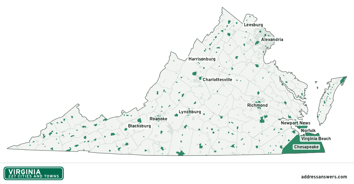
Virginia city limits map image
The map above as a picture: every Virginia city and town in green, with county lines. Boundaries from the Census Bureau, as of January 1, 2025.
You’re welcome to use it in a document or on your own site, with a link back to this page.
Download the map (PNG, 1,200 × 624)Questions about Virginia city limits
How many cities and towns are in Virginia?
Virginia has 227 incorporated places: 38 cities and 189 towns, by the Census Bureau’s boundary files for 2025.
What is the largest city in Virginia?
By population, Virginia Beach, with about 456,349 residents (2020–2024 American Community Survey 5-year estimates). By land area the largest is Suffolk, at 399.2 square miles (Virginia Beach: 244.7).
What is the smallest town in Virginia?
By the Census Bureau’s estimate, Clinchport, with 44 residents. Estimates for places this small have a wide margin of error, so treat it as a rough count.
How much of Virginia is unincorporated?
95% of its land and 5.6 million of its residents (64%) are outside every city or town. There, local government is the county. The state also has 473 named unincorporated communities; the largest is Arlington.
Is Arlington, VA a city?
No. Arlington is a census-designated place: a community the Census Bureau maps for statistics, with no city government of its own. About 236,254 people live there, in unincorporated Arlington County. An address there is outside city limits, even if its mailing address says otherwise.
Is Centreville, VA a city?
No. Centreville is a census-designated place: a community the Census Bureau maps for statistics, with no city government of its own. About 71,706 people live there, in unincorporated Fairfax County. An address there is outside city limits, even if its mailing address says otherwise.
Which cities and towns in Virginia are in more than one county?
Ten of the 227 cross a county line, by at least 1% of their land. The largest: Farmville (Prince Edward and Cumberland), Grottoes (Rockingham and Augusta), and Saltville (Smyth and Washington). Check an address to see which county it’s in.
Which county in Virginia has the most cities and towns?
Accomack County, with 14 at least partly inside it. 20 counties have none.
Bordering states
More answers for a Virginia address
Each tool checks the same address and puts its own answer first.
- County Census Your county, plus the township or town where those exist. Find your county
- School district Census The public school district that covers the address. Find your school district
- Flood zone FEMA The FEMA zone in plain English, and whether lenders require flood insurance. Check flood zone
- USDA home loans USDA Whether the property is in an area eligible for a USDA Rural Development loan. Check USDA eligibility
- Voting districts Census Your congressional district and your state senate and state house districts. Included in every check
Places, boundaries, land area and counties: US Census Bureau 2025 cartographic boundary files (boundaries as of January 1, 2025). A place is listed in each county that holds at least 1% of its land. Population: 2020–2024 American Community Survey 5-year estimates. Data updated October 24, 2026; page updated October 25, 2026. Boundaries change through annexation; your city or county has the official map.