West Virginia city limits map
West Virginia has 231 incorporated places: 79 cities, 146 towns, and 6 villages. They cover 1.9% of the state’s land and are home to 35% of its residents. Everyone else lives outside city limits, where local government is the county. Enter an address to see which side of a city line it’s on.
Result for
The map couldn’t load. The answers don’t depend on it.
The boundary couldn’t load. The answer doesn’t depend on it.
Census Geocoder match
More about this address
Sources and limits
- Census
- US Census Bureau Geocoder, current boundaries
- FEMA
- National Flood Hazard Layer, effective flood maps
- USDA
- Rural Development property eligibility
- Map
- Boundaries from Census TIGERweb, flood zones drawn by FEMA, eligible areas from USDA, base map © OpenStreetMap contributors
Census boundaries are updated once a year, so a recent annexation may not show yet. Informational only, not an official determination. Verify with your city or county.
West Virginia at a glance
- Incorporated places
- 231
- 79 cities, 146 towns, and 6 villages
- Residents in city limits
- 35%
- 620,238 of 1,778,373
- Land in city limits
- 1.9%
- 445.3 of 24,041 sq mi
- Counties
- 55
- Every one has at least one
- Unincorporated communities
- 208
- Largest: Teays Valley (14,151)
- Largest city
- Charleston
- 47,421 residents
All 231 cities and towns in West Virginia
Every incorporated place, largest first, with the counties it’s in and its size. An address inside one of these is inside city limits; anywhere else in the state is unincorporated.
| Name | Type | County | Population | Land (sq mi) |
|---|---|---|---|---|
| Charleston | City | Kanawha | 47,421 | 31.4 |
| Huntington | City | Cabell, Wayne | 45,787 | 16.5 |
| Morgantown | City | Monongalia | 30,236 | 10.2 |
| Parkersburg | City | Wood | 29,240 | 11.8 |
| Wheeling | City | Ohio | 26,350 | 13.6 |
| Martinsburg | City | Berkeley | 18,904 | 6.63 |
| Weirton | City | Hancock, Brooke | 18,647 | 18.1 |
| Fairmont | City | Marion | 18,221 | 8.60 |
| Beckley | City | Raleigh | 16,818 | 9.50 |
| Clarksburg | City | Harrison | 15,549 | 10.4 |
| South Charleston | City | Kanawha | 13,457 | 9.78 |
| St. Albans | City | Kanawha | 10,522 | 3.61 |
| Vienna | City | Wood | 10,518 | 3.97 |
| Bluefield | City | Mercer | 9,387 | 8.97 |
| Bridgeport | City | Harrison | 9,252 | 10.6 |
| Oak Hill | City | Fayette | 7,937 | 9.70 |
| Moundsville | City | Marshall | 7,869 | 2.91 |
| Charles Town | City | Jefferson | 7,337 | 5.87 |
| Dunbar | City | Kanawha | 7,254 | 2.80 |
| Hurricane | City | Putnam | 6,855 | 3.71 |
| Nitro | City | Kanawha, Putnam | 6,853 | 5.35 |
| Elkins | City | Randolph | 6,811 | 3.69 |
| Princeton | City | Mercer | 5,736 | 3.01 |
| Ranson | City | Jefferson | 5,729 | 8.10 |
| New Martinsville | City | Wetzel | 5,133 | 2.67 |
| Buckhannon | City | Upshur | 5,116 | 2.85 |
| Keyser | City | Mineral | 4,857 | 1.97 |
| Grafton | City | Taylor | 4,618 | 3.67 |
| Barboursville | Village | Cabell | 4,376 | 4.01 |
| Westover | City | Monongalia | 4,026 | 3.04 |
| Point Pleasant | City | Mason | 3,961 | 2.42 |
| Weston | City | Lewis | 3,840 | 1.94 |
| Lewisburg | City | Greenbrier | 3,835 | 3.80 |
| Ravenswood | City | Jackson | 3,830 | 1.82 |
| Welch | City | McDowell | 3,507 | 7.63 |
| Pleasant Valley | City | Marion | 3,482 | 3.23 |
| Summersville | City | Nicholas | 3,373 | 4.49 |
| Ripley | City | Jackson | 3,071 | 3.22 |
| Williamstown | City | Wood | 2,980 | 1.49 |
| Kingwood | City | Preston | 2,973 | 2.43 |
| Kenova | City | Wayne | 2,944 | 1.32 |
| Williamson | City | Mingo | 2,919 | 3.27 |
| Winfield | Town | Putnam | 2,918 | 2.36 |
| Philippi | City | Barbour | 2,861 | 2.83 |
| Fayetteville | Town | Fayette | 2,817 | 5.77 |
| Milton | Town | Cabell | 2,817 | 2.13 |
| Madison | City | Boone | 2,788 | 7.64 |
| Follansbee | City | Brooke | 2,757 | 1.84 |
| Bethlehem | Village | Ohio | 2,592 | 3.56 |
| White Sulphur Springs | City | Greenbrier | 2,549 | 1.87 |
| Moorefield | Town | Hardy | 2,525 | 2.67 |
| Paden City | City | Wetzel, Tyler | 2,415 | 0.85 |
| Richwood | City | Nicholas | 2,403 | 1.61 |
| Petersburg | City | Grant | 2,384 | 1.62 |
| Shinnston | City | Harrison | 2,352 | 1.66 |
| Spencer | City | Roane | 2,291 | 1.25 |
| Stonewood | City | Harrison | 2,212 | 0.82 |
| Wellsburg | City | Brooke | 2,203 | 0.97 |
| Chester | City | Hancock | 2,179 | 1.00 |
| St. Marys | City | Pleasants | 2,174 | 1.02 |
| Hinton | City | Summers | 2,086 | 2.24 |
| Nutter Fort | Town | Harrison | 2,075 | 0.90 |
| Mullens | City | Wyoming | 2,034 | 1.84 |
| Star City | Town | Monongalia | 1,960 | 0.49 |
| Romney | City | Hampshire | 1,922 | 1.06 |
| Terra Alta | Town | Preston | 1,841 | 1.19 |
| Mannington | City | Marion | 1,829 | 1.09 |
| McMechen | City | Marshall | 1,826 | 0.57 |
| Belington | Town | Barbour | 1,781 | 2.06 |
| Eleanor | Town | Putnam | 1,726 | 2.05 |
| Chesapeake | Town | Kanawha | 1,702 | 0.48 |
| Wayne | Town | Wayne | 1,675 | 1.18 |
| Salem | City | Harrison | 1,629 | 2.03 |
| Belle | Town | Kanawha | 1,611 | 0.69 |
| Harrisville | Town | Ritchie | 1,574 | 1.58 |
| Ceredo | City | Wayne | 1,528 | 1.31 |
| Sophia | Town | Raleigh | 1,528 | 0.70 |
| Marmet | City | Kanawha | 1,524 | 1.27 |
| Montgomery | City | Fayette, Kanawha | 1,516 | 1.62 |
| Mount Hope | City | Fayette | 1,504 | 1.85 |
| Athens | Town | Mercer | 1,494 | 0.40 |
| New Haven | Town | Mason | 1,493 | 1.10 |
| West Liberty | Town | Ohio | 1,481 | 1.09 |
| Glen Dale | City | Marshall | 1,461 | 0.85 |
| Shepherdstown | Town | Jefferson | 1,460 | 0.40 |
| Rainelle | Town | Greenbrier | 1,458 | 1.11 |
| Parsons | City | Tucker | 1,448 | 1.12 |
| Barrackville | Town | Marion | 1,430 | 0.69 |
| Ronceverte | City | Greenbrier | 1,419 | 1.70 |
| Sistersville | City | Tyler | 1,409 | 0.53 |
| Mabscott | Town | Raleigh | 1,396 | 0.93 |
| Alderson | Town | Greenbrier, Monroe | 1,383 | 0.89 |
| Pennsboro | City | Ritchie | 1,334 | 2.70 |
| Logan | City | Logan | 1,294 | 1.15 |
| Granville | Town | Monongalia | 1,257 | 1.30 |
| Benwood | City | Marshall | 1,230 | 1.30 |
| Bolivar | Town | Jefferson | 1,215 | 0.43 |
| Oceana | Town | Wyoming | 1,203 | 1.29 |
| Marlinton | Town | Pocahontas | 1,201 | 2.35 |
| Buffalo | Town | Putnam | 1,150 | 1.18 |
| Ansted | Town | Fayette | 1,140 | 1.72 |
| Hamlin | Town | Lincoln | 1,068 | 0.60 |
| Man | Town | Logan | 1,049 | 1.13 |
| Bethany | Town | Brooke | 1,039 | 0.73 |
| West Union | Town | Doddridge | 1,039 | 0.36 |
| Addison (Webster Springs) | Town | Webster | 1,038 | 0.45 |
| Glenville | Town | Gilmer | 1,037 | 1.00 |
| Carpendale | Town | Mineral | 1,035 | 1.31 |
| Belmont | City | Pleasants | 983 | 0.41 |
| Bath (Berkeley Springs) | Town | Morgan | 975 | 0.34 |
| White Hall | Town | Marion | 946 | 1.05 |
| New Cumberland | City | Hancock | 943 | 1.22 |
| Chapmanville | Town | Logan | 928 | 0.66 |
| North Hills | Town | Wood | 926 | 0.57 |
| Rupert | Town | Greenbrier | 909 | 0.77 |
| Clendenin | Town | Kanawha | 903 | 1.44 |
| Glasgow | Town | Kanawha | 878 | 0.47 |
| Poca | Town | Putnam | 872 | 0.55 |
| Gary | City | McDowell | 861 | 0.84 |
| East Bank | Town | Kanawha | 850 | 0.48 |
| Monongah | Town | Marion | 837 | 0.49 |
| Triadelphia | Town | Ohio | 825 | 0.67 |
| Sutton | Town | Braxton | 797 | 0.78 |
| Middlebourne | Town | Tyler | 796 | 0.36 |
| Mason | Town | Mason | 787 | 0.58 |
| Rowlesburg | Town | Preston | 773 | 1.01 |
| Piedmont | Town | Mineral | 735 | 0.38 |
| Smithers | City | Fayette | 712 | 1.44 |
| Lumberport | Town | Harrison | 703 | 0.50 |
| Gassaway | Town | Braxton | 688 | 1.16 |
| Davis | Town | Tucker | 663 | 2.01 |
| Mill Creek | Town | Randolph | 659 | 0.46 |
| Beverly | Town | Randolph | 629 | 0.42 |
| War | City | McDowell | 628 | 0.89 |
| Rivesville | Town | Marion | 627 | 0.52 |
| Cameron | City | Marshall | 609 | 0.86 |
| Thomas | City | Tucker | 599 | 3.49 |
| Peterstown | Town | Monroe | 594 | 0.32 |
| West Milford | Town | Harrison | 591 | 0.53 |
| West Hamlin | Town | Lincoln | 567 | 0.56 |
| Elizabeth | Town | Wirt | 564 | 0.47 |
| Hartford City | Town | Mason | 557 | 1.24 |
| Danville | Town | Boone | 549 | 0.97 |
| Burnsville | Town | Braxton | 547 | 1.06 |
| Anmoore | Town | Harrison | 522 | 1.06 |
| Masontown | Town | Preston | 518 | 0.28 |
| Grant Town | Town | Marion | 506 | 0.53 |
| Matewan | Town | Mingo | 505 | 0.55 |
| Meadow Bridge | Town | Fayette | 504 | 0.38 |
| Reedsville | Town | Preston | 504 | 0.65 |
| Clearview | Village | Ohio | 500 | 0.39 |
| Capon Bridge | Town | Hampshire | 497 | 0.71 |
| Windsor Heights | Village | Brooke | 491 | 0.14 |
| Cedar Grove | Town | Kanawha | 489 | 0.72 |
| Cowen | Town | Webster | 485 | 0.63 |
| Jane Lew | Town | Lewis | 480 | 0.24 |
| Union | Town | Monroe | 476 | 0.45 |
| Bancroft | Town | Putnam | 475 | 0.14 |
| Pineville | Town | Wyoming | 468 | 0.77 |
| Paw Paw | Town | Morgan | 459 | 0.53 |
| Beech Bottom | Village | Brooke | 443 | 1.16 |
| Pratt | Town | Kanawha | 438 | 0.29 |
| Fort Gay | Town | Wayne | 437 | 0.82 |
| Franklin | Town | Pendleton | 435 | 0.56 |
| Handley | Town | Kanawha | 418 | 0.95 |
| Gauley Bridge | Town | Fayette | 413 | 1.56 |
| Tunnelton | Town | Preston | 404 | 0.33 |
| Grantsville | Town | Calhoun | 401 | 0.44 |
| Farmington | Town | Marion | 390 | 0.42 |
| Mitchell Heights | Town | Logan | 385 | 0.34 |
| Hedgesville | Town | Berkeley | 379 | 0.13 |
| Clay | Town | Clay | 378 | 0.56 |
| Wardensville | Town | Hardy | 378 | 0.32 |
| Lester | Town | Raleigh | 377 | 0.50 |
| Hendricks | Town | Tucker | 375 | 0.31 |
| Hundred | Town | Wetzel | 371 | 0.50 |
| Pine Grove | Town | Wetzel | 367 | 0.35 |
| West Logan | Town | Logan | 365 | 0.34 |
| Valley Grove | Village | Ohio | 363 | 0.55 |
| Harpers Ferry | Town | Jefferson | 350 | 0.54 |
| Delbarton | Town | Mingo | 333 | 1.99 |
| Bradshaw | Town | McDowell | 327 | 0.77 |
| Flatwoods | Town | Braxton | 319 | 0.65 |
| Gilbert | Town | Mingo | 308 | 1.00 |
| Lost Creek | Town | Harrison | 302 | 1.21 |
| Bayard | Town | Grant | 299 | 0.31 |
| Montrose | Town | Randolph | 295 | 0.63 |
| Reedy | Town | Roane | 292 | 0.19 |
| Pullman | Town | Ritchie | 286 | 0.24 |
| Junior | Town | Barbour | 281 | 0.31 |
| Womelsdorf (Coalton) | Town | Randolph | 280 | 0.41 |
| Cairo | Town | Ritchie | 273 | 0.47 |
| Fairview | Town | Marion | 267 | 0.28 |
| Whitesville | Town | Boone | 266 | 0.22 |
| Albright | Town | Preston | 254 | 0.23 |
| Oakvale | Town | Mercer | 254 | 0.42 |
| Iaeger | Town | McDowell | 253 | 0.96 |
| Leon | Town | Mason | 252 | 0.32 |
| Flemington | Town | Taylor | 240 | 0.30 |
| Ridgeley | Town | Mineral | 239 | 0.29 |
| Kimball | Town | McDowell | 231 | 0.60 |
| Newburg | Town | Preston | 226 | 0.79 |
| Huttonsville | Town | Randolph | 225 | 0.30 |
| Quinwood | Town | Greenbrier | 221 | 0.35 |
| Durbin | Town | Pocahontas | 220 | 0.60 |
| Elk Garden | Town | Mineral | 212 | 0.26 |
| Ellenboro | Town | Ritchie | 209 | 1.12 |
| Hambleton | Town | Tucker | 203 | 0.22 |
| Hillsboro | Town | Pocahontas | 194 | 0.53 |
| Davy | Town | McDowell | 186 | 1.27 |
| Camden-on-Gauley | Town | Webster | 182 | 0.33 |
| Falling Spring | Town | Greenbrier | 182 | 0.51 |
| Henderson | Town | Mason | 174 | 0.42 |
| Northfork | Town | McDowell | 169 | 0.96 |
| Brandonville | Town | Preston | 166 | 0.39 |
| Kermit | Town | Mingo | 153 | 0.39 |
| Rhodell | Town | Raleigh | 137 | 0.31 |
| Bramwell | Town | Mercer | 135 | 0.55 |
| Sylvester | Town | Boone | 131 | 0.05 |
| Friendly | Town | Tyler | 123 | 0.10 |
| Harman | Town | Randolph | 119 | 0.32 |
| Smithfield | Town | Wetzel | 113 | 0.29 |
| Anawalt | Town | McDowell | 109 | 0.58 |
| Worthington | Town | Marion | 102 | 0.58 |
| Sand Fork | Town | Gilmer | 96 | 0.32 |
| Auburn | Town | Ritchie | 91 | 0.33 |
| Pax | Town | Fayette | 83 | 0.19 |
| Bruceton Mills | Town | Preston | 71 | 0.06 |
| Blacksville | Town | Monongalia | 55 | 0.30 |
| Keystone | City | McDowell | 39 | 0.32 |
| Thurmond | Town | Fayette | 5 | 0.18 |
Showing 1–50 of 231
Unincorporated communities in West Virginia
Census-designated places: named communities the Census Bureau maps for statistics, with no city government of their own. An address in one is outside city limits, even when its mailing address names a city. West Virginia has 208.
| Community | County | Population | Land (sq mi) |
|---|---|---|---|
| Teays Valley | Putnam | 14,151 | 7.26 |
| Cheat Lake | Monongalia | 10,902 | 14.3 |
| Cross Lanes | Kanawha | 9,671 | 6.25 |
| Pea Ridge | Cabell | 6,988 | 2.32 |
| Brookhaven | Monongalia | 6,212 | 9.24 |
| Pinch | Kanawha | 4,037 | 3.55 |
| Sissonville | Kanawha | 3,593 | 12.8 |
| Shannondale | Jefferson | 3,465 | 8.43 |
| Shady Spring | Raleigh | 3,381 | 6.20 |
| Blennerhassett | Wood | 3,282 | 4.98 |
| Culloden | Cabell | 3,040 | 3.93 |
| Inwood | Berkeley | 2,794 | 2.85 |
| Mineralwells | Wood | 2,389 | 1.54 |
| Craigsville | Nicholas | 2,190 | 6.07 |
| Falling Waters | Berkeley | 2,183 | 1.26 |
| Hooverson Heights | Brooke | 2,090 | 2.26 |
| Bluewell | Mercer | 1,992 | 4.50 |
| Alum Creek | Lincoln | 1,749 | 10.2 |
| Lubeck | Wood | 1,495 | 4.26 |
| MacArthur | Raleigh | 1,493 | 2.91 |
| Daniels | Raleigh | 1,489 | 4.63 |
| Stanaford | Raleigh | 1,449 | 1.91 |
| Bradley | Raleigh | 1,424 | 4.22 |
| Coal Fork | Kanawha | 1,423 | 5.13 |
| Mallory | Logan | 1,417 | 4.36 |
| Boaz | Wood | 1,400 | 3.58 |
| Prosperity | Raleigh | 1,389 | 2.46 |
| Lesage | Cabell | 1,329 | 6.09 |
| Fairlea | Greenbrier | 1,312 | 3.74 |
| Fort Ashby | Mineral | 1,283 | 3.31 |
| Newell | Hancock | 1,246 | 0.82 |
| Mount Gay-Shamrock | Logan | 1,166 | 7.55 |
| Cassville | Monongalia | 1,149 | 3.55 |
| Shenandoah Junction | Jefferson | 1,141 | 1.01 |
| Crab Orchard | Raleigh | 1,139 | 2.25 |
| Washington | Wood | 1,139 | 4.25 |
| Tornado | Kanawha | 1,114 | 3.59 |
| Brush Fork | Mercer | 1,096 | 1.90 |
| Enterprise | Harrison | 1,087 | 2.92 |
| Rand | Kanawha | 1,064 | 0.46 |
| Gilbert Creek | Mingo | 1,061 | 11.6 |
| Lavalette | Wayne | 1,005 | 2.61 |
| Piney View | Raleigh | 986 | 4.05 |
| Arthurdale | Preston | 982 | 4.96 |
| Despard | Harrison | 972 | 1.49 |
| Sprague | Raleigh | 952 | 0.63 |
| Accoville | Logan | 916 | 3.23 |
| McConnell | Logan | 818 | 0.31 |
| Corinne | Wyoming | 809 | 0.37 |
| Hometown | Putnam | 756 | 0.80 |
| Harts | Lincoln | 747 | 9.18 |
| Gallipolis Ferry | Mason | 731 | 2.28 |
| Coal City | Raleigh | 724 | 6.31 |
| Kopperston | Wyoming | 706 | 1.91 |
| Robinette | Logan | 706 | 3.00 |
| Beaver | Raleigh | 695 | 4.36 |
| Elkview | Kanawha | 671 | 1.68 |
| Holden | Logan | 670 | 3.73 |
| Valley Bend | Randolph | 661 | 1.41 |
| Lashmeet | Mercer | 655 | 0.75 |
| Bud | Wyoming | 644 | 3.12 |
| Bruno | Logan | 638 | 1.29 |
| Wiley Ford | Mineral | 630 | 2.88 |
| Big Chimney | Kanawha | 610 | 2.00 |
| Gatewood | Fayette | 605 | 1.54 |
| East View | Harrison | 604 | 1.01 |
| Great Cacapon | Morgan | 587 | 0.86 |
| Matheny | Wyoming | 586 | 3.50 |
| Tioga | Nicholas | 577 | 0.62 |
| Idamay | Marion | 575 | 0.88 |
| Chelyan | Kanawha | 564 | 0.43 |
| Jefferson | Kanawha | 534 | 0.33 |
| Institute | Kanawha | 521 | 0.28 |
| Crooked Creek | Logan | 517 | 0.57 |
| Stollings | Logan | 505 | 0.36 |
| Monaville | Logan | 502 | 0.46 |
| Springfield | Hampshire | 502 | 1.34 |
| Dupont City | Kanawha | 501 | 0.17 |
| Newark | Wirt | 495 | 0.94 |
| Montcalm | Mercer | 484 | 2.73 |
| Red Jacket | Mingo | 482 | 5.27 |
| Middleway | Jefferson | 479 | 1.12 |
| Powellton | Fayette | 479 | 5.35 |
| Sarah Ann | Logan | 473 | 1.83 |
| Chattaroy | Mingo | 467 | 2.04 |
| Valley Head | Randolph | 462 | 0.98 |
| West Dunbar | Kanawha | 425 | 0.23 |
| Glen Fork | Wyoming | 411 | 3.07 |
| Hilltop | Fayette | 397 | 0.65 |
| Verdunville | Logan | 396 | 2.67 |
| Prichard | Wayne | 389 | 1.11 |
| Falls View | Fayette | 372 | 0.33 |
| Waverly | Wood | 361 | 1.51 |
| Kimberly | Fayette | 357 | 0.89 |
| Crumpler | McDowell | 351 | 1.50 |
| Mount Carbon | Fayette | 347 | 0.15 |
| Racine | Boone | 331 | 0.48 |
| Bartley | McDowell | 327 | 1.14 |
| Eskdale | Kanawha | 326 | 0.38 |
| Raleigh | Raleigh | 325 | 0.19 |
| Henlawson | Logan | 324 | 0.80 |
| Malden | Kanawha | 320 | 0.12 |
| Kistler | Logan | 318 | 1.49 |
| Greenville | Logan | 317 | 0.14 |
| Cottageville | Jackson | 310 | 0.13 |
| Shrewsbury | Kanawha | 310 | 0.29 |
| East Dailey | Randolph | 292 | 1.05 |
| Hinkleville | Upshur | 291 | 0.66 |
| Ghent | Raleigh | 290 | 1.28 |
| Kincaid | Fayette | 285 | 0.86 |
| Aurora | Preston | 284 | 2.11 |
| Wallace | Harrison | 277 | 1.42 |
| Charlton Heights | Fayette | 276 | 0.41 |
| Rock Cave | Upshur | 276 | 3.10 |
| Salt Rock | Cabell | 274 | 3.07 |
| Brandywine | Pendleton | 267 | 0.49 |
| Carolina | Marion | 261 | 0.83 |
| Amherstdale | Logan | 256 | 2.99 |
| Greenview | Boone | 254 | 0.99 |
| Boomer | Fayette | 250 | 1.05 |
| Comfort | Boone | 220 | 1.00 |
| Neibert | Logan | 219 | 0.61 |
| Van | Boone | 214 | 0.60 |
| Wolf Summit | Harrison | 213 | 0.36 |
| Clifton | Mason | 211 | 0.26 |
| Big Creek | Logan | 210 | 0.58 |
| Apple Grove | Mason | 202 | 2.30 |
| Colcord | Raleigh | 201 | 0.12 |
| Chauncey | Logan | 198 | 1.44 |
| Norton | Randolph | 196 | 0.58 |
| Bolt | Raleigh | 195 | 5.45 |
| Glen White | Raleigh | 193 | 0.51 |
| Reader | Wetzel | 193 | 0.93 |
| Kanawha | Wood | 192 | 0.88 |
| Frank | Pocahontas | 188 | 0.38 |
| Omar | Logan | 188 | 1.13 |
| Crum | Wayne | 187 | 0.51 |
| Justice | Mingo | 186 | 1.32 |
| Adrian | Upshur | 183 | 0.84 |
| Nettie | Nicholas | 183 | 3.15 |
| Jacksonburg | Wetzel | 181 | 1.48 |
| Earling | Logan | 180 | 0.17 |
| Scarbro | Fayette | 176 | 0.67 |
| Cunard | Fayette | 165 | 0.11 |
| Raysal | McDowell | 162 | 1.24 |
| Baxter | Marion | 153 | 0.15 |
| Rossmore | Logan | 152 | 0.62 |
| St. George | Tucker | 142 | 1.06 |
| Switzer | Logan | 140 | 2.34 |
| Hepzibah | Harrison | 134 | 0.92 |
| Booth | Monongalia | 129 | 0.55 |
| Berwind | McDowell | 127 | 0.29 |
| Gypsy | Harrison | 119 | 0.78 |
| Justice Addition | Logan | 118 | 0.12 |
| Colliers | Brooke | 117 | 0.22 |
| Dorothy | Raleigh | 115 | 0.35 |
| Big Sandy | McDowell | 113 | 0.53 |
| Reynoldsville | Harrison | 111 | 1.36 |
| Century | Barbour | 110 | 0.13 |
| Garten | Fayette | 107 | 0.42 |
| Deep Water | Fayette | 104 | 0.88 |
| Twilight | Boone | 97 | 0.50 |
| Huntersville | Pocahontas | 95 | 1.13 |
| Burlington | Mineral | 94 | 1.23 |
| Covel | Wyoming | 90 | 0.21 |
| Page | Fayette | 90 | 0.44 |
| Littleton | Wetzel | 89 | 0.66 |
| Maybeury | McDowell | 88 | 1.67 |
| Cucumber | McDowell | 87 | 0.45 |
| Spelter | Harrison | 87 | 0.49 |
| Green Bank | Pocahontas | 84 | 3.30 |
| Green Spring | Hampshire | 84 | 2.20 |
| Itmann | Wyoming | 80 | 0.99 |
| Vivian | McDowell | 79 | 0.36 |
| Hansford | Kanawha | 77 | 0.08 |
| Hollygrove | Kanawha | 74 | 0.18 |
| Brenton | Wyoming | 71 | 0.63 |
| Galloway | Barbour | 71 | 0.63 |
| Eccles | Raleigh | 64 | 0.69 |
| Dixie | Nicholas | 56 | 0.73 |
| Prince | Fayette | 52 | 1.83 |
| Rachel | Marion | 52 | 0.34 |
| Bartow | Pocahontas | 47 | 0.46 |
| Beards Fork | Fayette | 46 | 1.68 |
| Glen Ferris | Fayette | 41 | 1.36 |
| Glen Jean | Fayette | 34 | 0.23 |
| Matoaka | Mercer | 30 | 0.26 |
| Raymond City | Putnam | 28 | 0.36 |
| Dailey | Randolph | 23 | 0.51 |
| New Richmond | Wyoming | 23 | 0.43 |
| Arbovale | Pocahontas | 20 | 0.58 |
| Bergoo | Webster | 20 | 0.21 |
| Belva | Nicholas | 17 | 0.14 |
| Fenwick | Nicholas | 16 | 0.14 |
| Hico | Fayette | 16 | 5.01 |
| Peach Creek | Logan | 14 | 0.25 |
| Parcoal | Webster | 12 | 0.17 |
| Birch River | Nicholas | 7 | 0.37 |
| Bowden | Randolph | 0 | 0.12 |
| Cass | Pocahontas | 0 | 0.72 |
| Helen | Raleigh | 0 | 0.24 |
| Helvetia | Randolph | 0 | 1.81 |
| Osage | Monongalia | 0 | 0.18 |
| Pageton | McDowell | 0 | 1.20 |
| Pentress | Monongalia | 0 | 0.61 |
| Pickens | Randolph | 0 | 2.03 |
| Roderfield | McDowell | 0 | 0.26 |
| Whitmer | Randolph | 0 | 0.42 |
Showing 1–50 of 208
Counties in West Virginia
55 counties, with how many cities and towns have land in each and the largest whose main county it is.
| County | Cities | Largest | Population | Land (sq mi) |
|---|---|---|---|---|
| Kanawha County | 15 | Charleston | 176,537 | 901.7 |
| Berkeley County | 2 | Martinsburg | 129,514 | 321.1 |
| Monongalia County | 5 | Morgantown | 107,163 | 360.1 |
| Cabell County | 3 | Huntington | 92,739 | 281.0 |
| Wood County | 4 | Parkersburg | 83,407 | 366.5 |
| Raleigh County | 5 | Beckley | 73,195 | 605.0 |
| Harrison County | 10 | Clarksburg | 64,984 | 416.0 |
| Jefferson County | 5 | Charles Town | 59,260 | 209.3 |
| Mercer County | 5 | Bluefield | 58,563 | 419.0 |
| Putnam County | 7 | Hurricane | 57,177 | 345.7 |
| Marion County | 11 | Fairmont | 55,909 | 308.8 |
| Ohio County | 6 | Wheeling | 41,582 | 106.0 |
| Fayette County | 10 | Oak Hill | 39,519 | 662.0 |
| Wayne County | 5 | Kenova | 38,164 | 506.0 |
| Preston County | 10 | Kingwood | 34,160 | 648.8 |
| Greenbrier County | 8 | Lewisburg | 32,386 | 1,020 |
| Logan County | 5 | Logan | 31,418 | 452.9 |
| Marshall County | 5 | Moundsville | 29,865 | 305.4 |
| Hancock County | 3 | Weirton | 28,431 | 82.6 |
| Jackson County | 2 | Ravenswood | 27,705 | 464.4 |
| Randolph County | 7 | Elkins | 27,576 | 1,040 |
| Mineral County | 5 | Keyser | 26,854 | 327.9 |
| Mason County | 6 | Point Pleasant | 25,043 | 430.8 |
| Nicholas County | 2 | Summersville | 24,277 | 646.8 |
| Upshur County | 1 | Buckhannon | 23,712 | 354.6 |
| Hampshire County | 2 | Romney | 23,465 | 640.4 |
| Mingo County | 5 | Williamson | 22,542 | 423.1 |
| Brooke County | 6 | Follansbee | 21,805 | 89.0 |
| Boone County | 4 | Madison | 21,026 | 502.4 |
| Wyoming County | 3 | Mullens | 20,629 | 499.5 |
| Lincoln County | 2 | Hamlin | 19,902 | 437.1 |
| McDowell County | 10 | Welch | 17,943 | 533.5 |
| Morgan County | 2 | Bath (Berkeley Springs) | 17,426 | 229.1 |
| Lewis County | 2 | Weston | 16,740 | 386.9 |
| Taylor County | 2 | Grafton | 16,487 | 172.8 |
| Barbour County | 3 | Philippi | 15,424 | 341.1 |
| Hardy County | 2 | Moorefield | 14,243 | 582.3 |
| Wetzel County | 5 | New Martinsville | 14,078 | 358.1 |
| Roane County | 2 | Spencer | 13,786 | 483.6 |
| Monroe County | 3 | Peterstown | 12,386 | 472.8 |
| Braxton County | 4 | Sutton | 12,208 | 510.7 |
| Summers County | 1 | Hinton | 11,729 | 360.6 |
| Grant County | 2 | Petersburg | 10,983 | 477.4 |
| Ritchie County | 6 | Harrisville | 8,286 | 452.0 |
| Webster County | 3 | Addison (Webster Springs) | 8,144 | 553.5 |
| Tyler County | 4 | Sistersville | 8,064 | 256.3 |
| Clay County | 1 | Clay | 7,835 | 342.0 |
| Pocahontas County | 3 | Marlinton | 7,784 | 940.2 |
| Doddridge County | 1 | West Union | 7,711 | 319.7 |
| Pleasants County | 2 | St. Marys | 7,521 | 130.1 |
| Gilmer County | 2 | Glenville | 7,288 | 338.5 |
| Tucker County | 5 | Parsons | 6,654 | 419.0 |
| Calhoun County | 1 | Grantsville | 6,048 | 279.3 |
| Pendleton County | 1 | Franklin | 6,043 | 696.0 |
| Wirt County | 1 | Elizabeth | 5,053 | 232.5 |
Showing 1–50 of 55
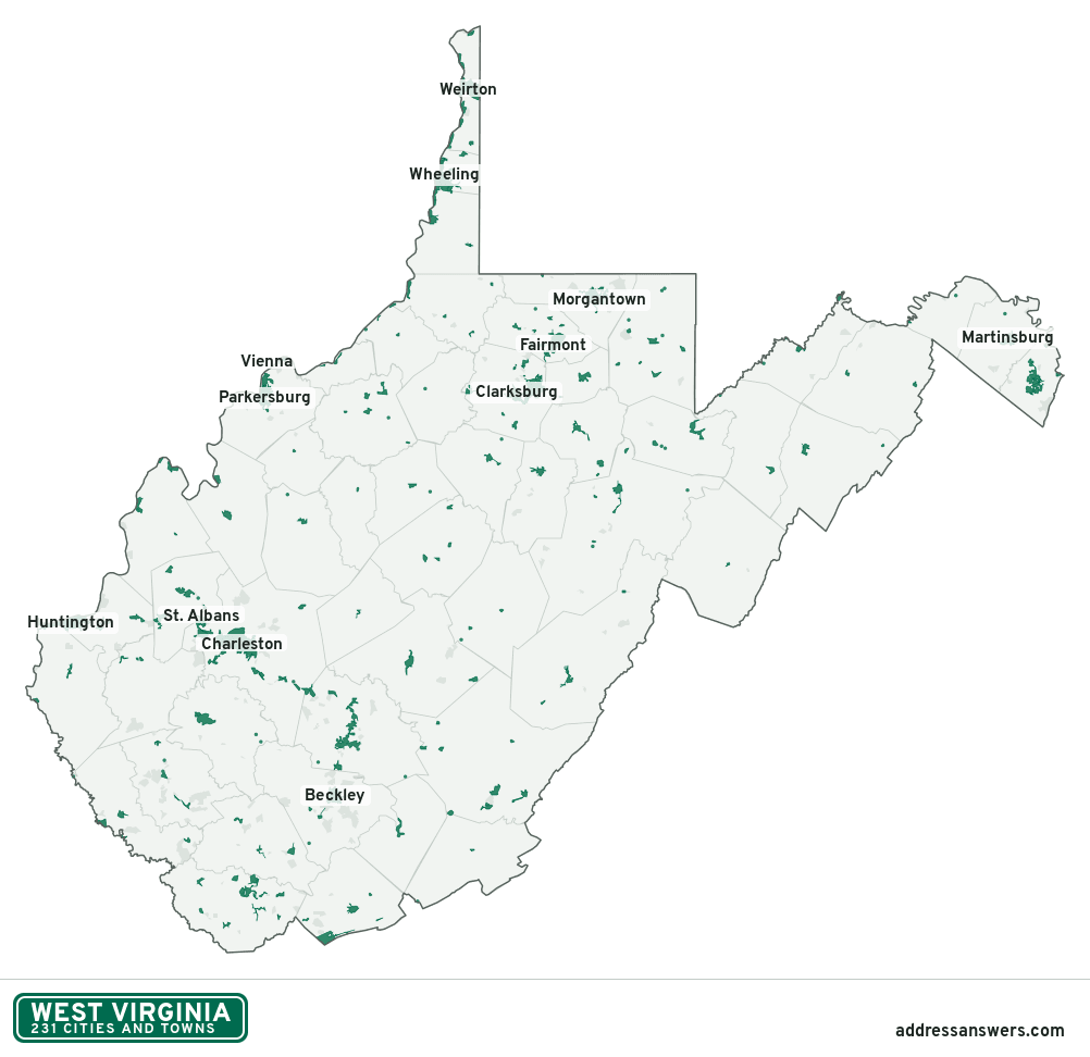
West Virginia city limits map image
The map above as a picture: every West Virginia city and town in green, with county lines. Boundaries from the Census Bureau, as of January 1, 2025.
You’re welcome to use it in a document or on your own site, with a link back to this page.
Download the map (PNG, 1,002 × 972)Questions about West Virginia city limits
How many cities and towns are in West Virginia?
West Virginia has 231 incorporated places: 79 cities, 146 towns, and 6 villages, by the Census Bureau’s boundary files for 2025.
What is the largest city in West Virginia?
By population, Charleston, with about 47,421 residents (2020–2024 American Community Survey 5-year estimates). It is also the largest by land area, at 31.4 square miles.
What is the smallest town in West Virginia?
By the Census Bureau’s estimate, Thurmond, with 5 residents. Estimates for places this small have a wide margin of error, so treat it as a rough count.
How much of West Virginia is unincorporated?
98% of its land and 1.2 million of its residents (65%) are outside every city or town. There, local government is the county. The state also has 208 named unincorporated communities; the largest is Teays Valley.
Is Teays Valley, WV a city?
No. Teays Valley is a census-designated place: a community the Census Bureau maps for statistics, with no city government of its own. About 14,151 people live there, in unincorporated Putnam County. An address there is outside city limits, even if its mailing address says otherwise.
Is Cheat Lake, WV a city?
No. Cheat Lake is a census-designated place: a community the Census Bureau maps for statistics, with no city government of its own. About 10,902 people live there, in unincorporated Monongalia County. An address there is outside city limits, even if its mailing address says otherwise.
Which cities and towns in West Virginia are in more than one county?
Six of the 231 cross a county line, by at least 1% of their land. The largest: Huntington (Cabell and Wayne), Weirton (Hancock and Brooke), and Nitro (Kanawha and Putnam). Check an address to see which county it’s in.
Which county in West Virginia has the most cities and towns?
Kanawha County, with 15 at least partly inside it. Every county in West Virginia has at least one.
Bordering states
More answers for a West Virginia address
Each tool checks the same address and puts its own answer first.
- County Census Your county, plus the township or town where those exist. Find your county
- School district Census The public school district that covers the address. Find your school district
- Flood zone FEMA The FEMA zone in plain English, and whether lenders require flood insurance. Check flood zone
- USDA home loans USDA Whether the property is in an area eligible for a USDA Rural Development loan. Check USDA eligibility
- Voting districts Census Your congressional district and your state senate and state house districts. Included in every check
Places, boundaries, land area and counties: US Census Bureau 2025 cartographic boundary files (boundaries as of January 1, 2025). A place is listed in each county that holds at least 1% of its land. Population: 2020–2024 American Community Survey 5-year estimates. Data updated October 24, 2026; page updated October 25, 2026. Boundaries change through annexation; your city or county has the official map.