Illinois city limits map
Illinois has 1,294 incorporated places: 300 cities, 978 villages, and 16 towns. They cover 8.3% of the state’s land and are home to 87% of its residents. Everyone else lives outside city limits, where local government is the township and the county. Enter an address to see which side of a city line it’s on.
Result for
The map couldn’t load. The answers don’t depend on it.
The boundary couldn’t load. The answer doesn’t depend on it.
Census Geocoder match
More about this address
Sources and limits
- Census
- US Census Bureau Geocoder, current boundaries
- FEMA
- National Flood Hazard Layer, effective flood maps
- USDA
- Rural Development property eligibility
- Map
- Boundaries from Census TIGERweb, flood zones drawn by FEMA, eligible areas from USDA, base map © OpenStreetMap contributors
Census boundaries are updated once a year, so a recent annexation may not show yet. Informational only, not an official determination. Verify with your city or county.
Illinois at a glance
- Incorporated places
- 1,294
- 300 cities, 978 villages, and 16 towns
- Residents in city limits
- 87%
- 11,101,902 of 12,694,798
- Land in city limits
- 8.3%
- 4,624 of 55,514 sq mi
- Counties
- 102
- Every one has at least one
- Unincorporated communities
- 167
- Largest: Gages Lake (10,819)
- Largest city
- Chicago
- 2.7 million residents
How local government works in Illinois
The Census Bureau maps 1,426 townships in Illinois. Most counties have them, each with an elected supervisor, assessor and highway commissioner. A township isn’t a city, so an address in one is outside city limits unless it’s also inside a city.
City limits maps for 8 Illinois cities
Every Illinois city with 100,000 or more residents has its own page: the boundary in detail, the places around it and its school districts.
All 1,294 cities and villages in Illinois
Every incorporated place, largest first, with the counties it’s in and its size. An address inside one of these is inside city limits; anywhere else in the state is unincorporated.
| Name | Type | County | Population | Land (sq mi) |
|---|---|---|---|---|
| Chicago | City | Cook | 2,711,226 | 227.7 |
| Aurora | City | Kane, DuPage +2 | 179,898 | 45.2 |
| Naperville | City | DuPage, Will | 150,692 | 39.4 |
| Joliet | City | Will, Kendall | 150,445 | 66.3 |
| Rockford | City | Winnebago | 147,521 | 65.4 |
| Elgin | City | Kane, Cook | 114,934 | 38.3 |
| Springfield | City | Sangamon | 113,330 | 61.3 |
| Peoria | City | Peoria | 112,169 | 48.2 |
| Champaign | City | Champaign | 89,996 | 23.0 |
| Waukegan | City | Lake | 89,076 | 24.3 |
| Cicero | Town | Cook | 82,797 | 5.87 |
| Bloomington | City | McLean | 78,907 | 27.1 |
| Schaumburg | Village | Cook | 76,868 | 19.4 |
| Evanston | City | Cook | 76,340 | 7.78 |
| Arlington Heights | Village | Cook | 76,005 | 16.6 |
| Bolingbrook | Village | Will, DuPage | 74,096 | 25.0 |
| Decatur | City | Macon | 69,815 | 44.2 |
| Palatine | Village | Cook | 66,293 | 14.1 |
| Skokie | Village | Cook | 66,219 | 10.1 |
| Des Plaines | City | Cook | 59,156 | 14.2 |
| Orland Park | Village | Cook, Will | 57,916 | 22.0 |
| Oak Lawn | Village | Cook | 56,861 | 8.57 |
| Berwyn | City | Cook | 55,595 | 3.90 |
| Mount Prospect | Village | Cook | 55,472 | 10.7 |
| Tinley Park | Village | Cook, Will | 54,842 | 16.2 |
| Normal | Town | McLean | 53,569 | 18.7 |
| Wheaton | City | DuPage | 53,557 | 11.3 |
| Oak Park | Village | Cook | 53,292 | 4.70 |
| Hoffman Estates | Village | Cook | 51,175 | 20.5 |
| Downers Grove | Village | DuPage | 50,054 | 14.7 |
| Glenview | Village | Cook | 47,752 | 14.5 |
| Plainfield | Village | Will, Kendall | 46,708 | 26.1 |
| Elmhurst | City | DuPage | 45,671 | 10.2 |
| Lombard | Village | DuPage | 43,619 | 10.2 |
| Buffalo Grove | Village | Lake, Cook | 42,891 | 9.57 |
| Moline | City | Rock Island | 42,197 | 16.8 |
| Belleville | City | St. Clair | 41,370 | 23.2 |
| Romeoville | Village | Will | 41,152 | 19.4 |
| Crystal Lake | City | McHenry | 40,579 | 19.0 |
| Bartlett | Village | DuPage, Cook +1 | 40,501 | 15.7 |
| DeKalb | City | DeKalb | 40,443 | 17.8 |
| Carol Stream | Village | DuPage | 39,460 | 9.30 |
| Urbana | City | Champaign | 39,341 | 11.8 |
| Quincy | City | Adams | 39,109 | 15.9 |
| Streamwood | Village | Cook | 39,001 | 7.80 |
| Park Ridge | City | Cook | 38,667 | 7.09 |
| Wheeling | Village | Cook | 38,433 | 8.67 |
| Carpentersville | Village | Kane | 37,346 | 7.86 |
| Hanover Park | Village | DuPage, Cook | 36,732 | 6.42 |
| Oswego | Village | Kendall | 36,375 | 16.2 |
| Rock Island | City | Rock Island | 36,151 | 17.5 |
| Addison | Village | DuPage | 35,489 | 9.84 |
| Calumet City | City | Cook | 35,100 | 7.20 |
| Northbrook | Village | Cook | 34,585 | 13.2 |
| Woodridge | Village | DuPage, Will | 33,941 | 9.63 |
| St. Charles | City | Kane, DuPage | 32,854 | 14.5 |
| Glendale Heights | Village | DuPage | 32,808 | 5.39 |
| O'Fallon | City | St. Clair | 32,262 | 15.8 |
| Elk Grove Village | Village | Cook, DuPage | 31,987 | 11.8 |
| Mundelein | Village | Lake | 31,915 | 10.9 |
| Pekin | City | Tazewell | 31,781 | 16.0 |
| North Chicago | City | Lake | 30,643 | 8.00 |
| Gurnee | Village | Lake | 30,510 | 13.5 |
| Highland Park | City | Lake | 30,398 | 12.2 |
| Algonquin | Village | McHenry, Kane | 30,067 | 12.6 |
| Niles | Village | Cook | 30,064 | 5.85 |
| Galesburg | City | Knox | 29,481 | 17.8 |
| Lake in the Hills | Village | McHenry | 28,800 | 10.2 |
| Burbank | City | Cook | 28,739 | 4.18 |
| Danville | City | Vermilion | 28,595 | 17.9 |
| Glen Ellyn | Village | DuPage | 28,390 | 7.00 |
| Lansing | Village | Cook | 28,284 | 7.46 |
| McHenry | City | McHenry | 28,074 | 15.0 |
| New Lenox | Village | Will | 28,006 | 16.1 |
| Huntley | Village | McHenry, Kane | 28,005 | 14.7 |
| Wilmette | Village | Cook | 27,503 | 5.40 |
| Batavia | City | Kane | 27,151 | 11.0 |
| Round Lake Beach | Village | Lake | 27,079 | 5.05 |
| Vernon Hills | Village | Lake | 26,876 | 7.74 |
| Oak Forest | City | Cook | 26,805 | 6.05 |
| Chicago Heights | City | Cook | 26,736 | 10.4 |
| Granite City | City | Madison | 26,549 | 19.0 |
| Edwardsville | City | Madison | 26,474 | 20.0 |
| Lockport | City | Will | 26,409 | 11.8 |
| Woodstock | City | McHenry | 26,147 | 13.2 |
| West Chicago | City | DuPage | 25,395 | 15.5 |
| Alton | City | Madison | 25,279 | 15.7 |
| Belvidere | City | Boone | 24,752 | 12.8 |
| Morton Grove | Village | Cook | 24,619 | 5.09 |
| Zion | City | Lake | 24,600 | 9.94 |
| Melrose Park | Village | Cook | 24,549 | 4.35 |
| Homer Glen | Village | Will | 24,529 | 22.2 |
| South Elgin | Village | Kane | 24,217 | 7.32 |
| Collinsville | City | Madison, St. Clair | 24,031 | 15.4 |
| Rolling Meadows | City | Cook | 24,027 | 5.62 |
| Kankakee | City | Kankakee | 23,996 | 15.1 |
| Elmwood Park | Village | Cook | 23,868 | 1.91 |
| Westmont | Village | DuPage | 23,724 | 5.03 |
| Yorkville | City | Kendall | 23,617 | 20.4 |
| Freeport | City | Stephenson | 23,505 | 11.9 |
| Loves Park | City | Winnebago, Boone | 23,502 | 16.3 |
| Lisle | Village | DuPage | 23,407 | 6.90 |
| Maywood | Village | Cook | 23,201 | 2.72 |
| Roselle | Village | DuPage, Cook | 22,752 | 5.55 |
| Machesney Park | Village | Winnebago | 22,630 | 12.7 |
| Bloomingdale | Village | DuPage | 22,457 | 6.77 |
| Villa Park | Village | DuPage | 22,345 | 4.72 |
| East Peoria | City | Tazewell | 22,324 | 20.7 |
| Carbondale | City | Jackson | 22,158 | 17.5 |
| Darien | City | DuPage | 21,879 | 6.17 |
| Blue Island | City | Cook | 21,741 | 4.07 |
| Montgomery | Village | Kane, Kendall | 21,515 | 10.0 |
| Geneva | City | Kane | 21,258 | 10.1 |
| Park Forest | Village | Cook, Will | 21,156 | 4.98 |
| Grayslake | Village | Lake | 20,929 | 10.9 |
| South Holland | Village | Cook | 20,911 | 7.24 |
| East Moline | City | Rock Island | 20,904 | 14.6 |
| Dolton | Village | Cook | 20,825 | 4.57 |
| Frankfort | Village | Will, Cook | 20,651 | 15.6 |
| Crest Hill | City | Will | 20,628 | 9.01 |
| Libertyville | Village | Lake | 20,525 | 8.81 |
| Harvey | City | Cook | 20,230 | 6.21 |
| Mokena | Village | Will | 20,021 | 8.72 |
| Lake Zurich | Village | Lake | 19,832 | 6.92 |
| Deerfield | Village | Lake, Cook | 19,518 | 5.54 |
| Evergreen Park | Village | Cook | 19,420 | 3.16 |
| Lake Forest | City | Lake | 19,416 | 17.2 |
| Brookfield | Village | Cook | 19,331 | 3.06 |
| Homewood | Village | Cook | 19,294 | 5.01 |
| North Aurora | Village | Kane | 18,696 | 7.58 |
| Matteson | Village | Cook | 18,645 | 9.29 |
| Round Lake | Village | Lake | 18,628 | 5.56 |
| Bensenville | Village | DuPage, Cook | 18,603 | 5.53 |
| Alsip | Village | Cook | 18,583 | 6.53 |
| Sycamore | City | DeKalb | 18,559 | 10.1 |
| Ottawa | City | LaSalle | 18,447 | 14.9 |
| Shorewood | Village | Will | 18,343 | 8.14 |
| Bellwood | Village | Cook | 18,256 | 2.40 |
| Franklin Park | Village | Cook | 18,197 | 4.78 |
| Palos Hills | City | Cook | 18,081 | 4.25 |
| Bourbonnais | Village | Kankakee | 18,078 | 9.18 |
| Jacksonville | City | Morgan | 18,014 | 10.6 |
| East St. Louis | City | St. Clair | 17,999 | 13.9 |
| Cary | Village | McHenry | 17,923 | 6.53 |
| Lemont | Village | Cook, DuPage +1 | 17,820 | 9.14 |
| Godfrey | Village | Madison | 17,712 | 34.4 |
| Hinsdale | Village | DuPage, Cook | 17,175 | 4.62 |
| Cahokia Heights | City | St. Clair | 17,106 | 15.8 |
| Charleston | City | Coles | 17,062 | 9.08 |
| Bridgeview | Village | Cook | 16,849 | 4.12 |
| Marion | City | Williamson | 16,836 | 14.4 |
| Fairview Heights | City | St. Clair | 16,745 | 11.5 |
| Morton | Village | Tazewell | 16,595 | 12.9 |
| Mattoon | City | Coles | 16,586 | 10.3 |
| Westchester | Village | Cook | 16,436 | 3.69 |
| Country Club Hills | City | Cook | 16,324 | 4.97 |
| La Grange | Village | Cook | 15,998 | 2.52 |
| Washington | City | Tazewell | 15,919 | 8.58 |
| Prospect Heights | City | Cook | 15,618 | 4.21 |
| Norridge | Village | Cook | 15,439 | 1.81 |
| Bradley | Village | Kankakee | 15,325 | 7.27 |
| Dixon | City | Lee | 14,910 | 9.48 |
| Morris | City | Grundy | 14,898 | 12.7 |
| Macomb | City | McDonough | 14,894 | 10.8 |
| Antioch | Village | Lake | 14,859 | 8.28 |
| Warrenville | City | DuPage | 14,718 | 5.43 |
| Sterling | City | Whiteside | 14,717 | 5.95 |
| Swansea | Village | St. Clair | 14,710 | 6.48 |
| Chatham | Village | Sangamon | 14,639 | 7.52 |
| Shiloh | Village | St. Clair | 14,572 | 12.7 |
| Hickory Hills | City | Cook | 14,526 | 2.84 |
| Lindenhurst | Village | Lake | 14,417 | 4.53 |
| Beach Park | Village | Lake | 14,115 | 7.08 |
| Chicago Ridge | Village | Cook | 14,099 | 2.27 |
| Mount Vernon | City | Jefferson | 14,090 | 14.7 |
| Wauconda | Village | Lake | 14,027 | 5.07 |
| Glen Carbon | Village | Madison | 13,977 | 10.3 |
| Midlothian | Village | Cook | 13,948 | 2.82 |
| Forest Park | Village | Cook | 13,943 | 2.40 |
| Wood Dale | City | DuPage | 13,933 | 4.87 |
| Channahon | Village | Will, Grundy | 13,927 | 16.8 |
| Hazel Crest | Village | Cook | 13,792 | 3.61 |
| La Grange Park | Village | Cook | 13,447 | 2.23 |
| Western Springs | Village | Cook | 13,446 | 2.78 |
| Lincoln | City | Logan | 13,281 | 6.35 |
| Canton | City | Fulton | 13,144 | 8.39 |
| Lincolnwood | Village | Cook | 13,112 | 2.69 |
| Minooka | Village | Grundy, Kendall +1 | 12,891 | 9.10 |
| Richton Park | Village | Cook | 12,521 | 4.39 |
| Northlake | City | Cook | 12,513 | 3.18 |
| Winnetka | Village | Cook | 12,484 | 3.81 |
| Rantoul | Village | Champaign | 12,421 | 8.49 |
| Effingham | City | Effingham | 12,342 | 10.9 |
| Streator | City | LaSalle, Livingston | 12,330 | 7.32 |
| Justice | Village | Cook | 12,324 | 2.84 |
| Herrin | City | Williamson | 12,226 | 9.67 |
| Plano | City | Kendall | 12,203 | 9.02 |
| Palos Heights | City | Cook | 12,152 | 3.78 |
| River Forest | Village | Cook | 11,992 | 2.48 |
| Kewanee | City | Henry | 11,913 | 6.60 |
| Centralia | City | Marion, Clinton +2 | 11,856 | 8.20 |
| Troy | City | Madison | 11,647 | 6.24 |
| Schiller Park | Village | Cook | 11,393 | 2.77 |
| Markham | City | Cook | 11,355 | 5.40 |
| Pontiac | City | Livingston | 11,294 | 8.44 |
| Burr Ridge | Village | DuPage, Cook | 11,141 | 7.47 |
| Fox Lake | Village | Lake, McHenry | 11,131 | 7.83 |
| Waterloo | City | Monroe | 11,129 | 8.29 |
| Columbia | City | Monroe, St. Clair | 11,127 | 10.6 |
| Barrington | Village | Cook, Lake | 11,077 | 4.62 |
| Manhattan | Village | Will | 11,026 | 6.75 |
| Pingree Grove | Village | Kane | 10,914 | 4.04 |
| Campton Hills | Village | Kane | 10,877 | 16.9 |
| Summit | Village | Cook | 10,846 | 2.12 |
| Roscoe | Village | Winnebago | 10,706 | 10.3 |
| Worth | Village | Cook | 10,700 | 2.37 |
| Taylorville | City | Christian | 10,646 | 10.3 |
| Crestwood | Village | Cook | 10,579 | 3.05 |
| River Grove | Village | Cook | 10,451 | 2.39 |
| Riverdale | Village | Cook | 10,340 | 3.58 |
| Lyons | Village | Cook | 10,339 | 2.21 |
| Wood River | City | Madison | 10,279 | 6.98 |
| Highland | City | Madison | 10,262 | 7.16 |
| Winfield | Village | DuPage | 10,095 | 3.09 |
| Mahomet | Village | Champaign | 10,049 | 9.72 |
| Peru | City | LaSalle, Bureau | 9,775 | 10.4 |
| Sauk Village | Village | Cook | 9,678 | 3.99 |
| Harvard | City | McHenry | 9,598 | 8.38 |
| Rochelle | City | Ogle | 9,529 | 13.8 |
| LaSalle | City | LaSalle | 9,498 | 13.5 |
| Steger | Village | Cook, Will | 9,418 | 3.41 |
| Flossmoor | Village | Cook | 9,391 | 3.67 |
| Itasca | Village | DuPage | 9,355 | 5.07 |
| Sugar Grove | Village | Kane | 9,240 | 11.7 |
| Bethalto | Village | Madison | 9,239 | 7.61 |
| Hawthorn Woods | Village | Lake | 9,143 | 8.27 |
| Willowbrook | Village | DuPage | 9,131 | 2.58 |
| Lynwood | Village | Cook | 9,083 | 5.14 |
| Riverside | Village | Cook | 9,039 | 1.98 |
| Manteno | Village | Kankakee | 9,030 | 5.35 |
| Savoy | Village | Champaign | 8,968 | 3.29 |
| Harwood Heights | Village | Cook | 8,821 | 0.82 |
| Mascoutah | City | St. Clair | 8,816 | 9.64 |
| Glencoe | Village | Cook | 8,701 | 3.72 |
| Lake Villa | Village | Lake | 8,683 | 6.53 |
| Clarendon Hills | Village | DuPage | 8,659 | 1.81 |
| Gilberts | Village | Kane | 8,606 | 5.49 |
| Glenwood | Village | Cook | 8,603 | 3.28 |
| Rock Falls | City | Whiteside | 8,587 | 3.98 |
| Monmouth | City | Warren | 8,581 | 4.25 |
| Olney | City | Richland | 8,577 | 6.96 |
| Hampshire | Village | Kane | 8,524 | 10.1 |
| Crete | Village | Will | 8,386 | 9.45 |
| Harrisburg | City | Saline | 8,372 | 6.61 |
| Maryville | Village | Madison | 8,316 | 5.80 |
| Long Grove | Village | Lake | 8,305 | 12.4 |
| Paris | City | Edgar | 8,276 | 5.68 |
| Hillside | Village | Cook | 8,084 | 3.17 |
| Oak Brook | Village | DuPage | 8,056 | 7.98 |
| Island Lake | Village | McHenry, Lake | 8,014 | 3.38 |
| Lincolnshire | Village | Lake | 7,980 | 4.57 |
| Princeton | City | Bureau | 7,975 | 8.23 |
| Rockton | Village | Winnebago | 7,974 | 6.86 |
| Silvis | City | Rock Island | 7,955 | 4.28 |
| South Beloit | City | Winnebago | 7,946 | 6.17 |
| Round Lake Park | Village | Lake | 7,919 | 2.07 |
| West Dundee | Village | Kane | 7,906 | 4.02 |
| Broadview | Village | Cook | 7,896 | 1.78 |
| Park City | City | Lake | 7,827 | 1.16 |
| Jerseyville | City | Jersey | 7,445 | 5.24 |
| University Park | Village | Will | 7,306 | 10.7 |
| Inverness | Village | Cook | 7,275 | 6.53 |
| North Riverside | Village | Cook | 7,249 | 1.64 |
| Salem | City | Marion | 7,236 | 6.99 |
| Greenville | City | Bond | 7,235 | 6.31 |
| Sandwich | City | DeKalb, Kendall | 7,219 | 4.76 |
| West Frankfort | City | Franklin | 7,118 | 4.98 |
| Robinson | City | Crawford | 7,084 | 4.70 |
| Marengo | City | McHenry | 7,040 | 8.88 |
| Mendota | City | LaSalle | 6,994 | 5.13 |
| Clinton | City | De Witt | 6,985 | 3.57 |
| Stickney | Village | Cook | 6,952 | 1.92 |
| Benton | City | Franklin | 6,863 | 5.49 |
| Calumet Park | Village | Cook | 6,855 | 1.12 |
| Mount Carmel | City | Wabash | 6,854 | 4.81 |
| Litchfield | City | Montgomery | 6,834 | 8.96 |
| Chester | City | Randolph | 6,797 | 5.77 |
| Murphysboro | City | Jackson | 6,735 | 5.25 |
| Orland Hills | Village | Cook | 6,719 | 1.14 |
| Volo | Village | Lake | 6,706 | 4.12 |
| Geneseo | City | Henry | 6,673 | 4.71 |
| Winthrop Harbor | Village | Lake | 6,559 | 4.65 |
| Lakemoor | Village | McHenry, Lake | 6,467 | 5.28 |
| Johnsburg | Village | McHenry | 6,386 | 7.25 |
| Elburn | Village | Kane | 6,354 | 3.75 |
| Monticello | City | Piatt | 6,304 | 4.03 |
| Countryside | City | Cook | 6,267 | 2.88 |
| Beardstown | City | Cass | 6,169 | 3.66 |
| Braidwood | City | Will, Grundy | 6,062 | 5.30 |
| Lake Bluff | Village | Lake | 6,041 | 4.08 |
| Pontoon Beach | Village | Madison | 6,025 | 9.83 |
| Spring Grove | Village | McHenry | 5,917 | 9.05 |
| Chillicothe | City | Peoria | 5,900 | 5.27 |
| Willow Springs | Village | Cook | 5,868 | 4.15 |
| Metropolis | City | Massac | 5,864 | 6.01 |
| Bartonville | Village | Peoria | 5,841 | 8.05 |
| Peoria Heights | Village | Peoria, Tazewell | 5,825 | 2.49 |
| Carterville | City | Williamson | 5,818 | 5.30 |
| Hillsboro | City | Montgomery | 5,803 | 8.75 |
| Vandalia | City | Fayette | 5,796 | 8.15 |
| Du Quoin | City | Perry | 5,726 | 6.98 |
| East Alton | Village | Madison | 5,689 | 5.32 |
| Mount Zion | Village | Macon | 5,660 | 4.28 |
| Wilmington | City | Will | 5,494 | 14.0 |
| Genoa | City | DeKalb | 5,492 | 2.60 |
| Northfield | Village | Cook | 5,487 | 3.23 |
| Carlinville | City | Macoupin | 5,480 | 3.37 |
| Spring Valley | City | Bureau | 5,476 | 7.41 |
| Lake Barrington | Village | Lake | 5,442 | 5.74 |
| Coal City | Village | Grundy, Will | 5,317 | 5.77 |
| Highwood | City | Lake | 5,301 | 0.72 |
| Posen | Village | Cook | 5,292 | 1.17 |
| Pana | City | Christian, Shelby | 5,217 | 3.86 |
| Berkeley | Village | Cook | 5,199 | 1.40 |
| Colona | City | Henry | 5,139 | 3.82 |
| Monee | Village | Will | 5,108 | 4.62 |
| Hoopeston | City | Vermilion | 5,034 | 3.69 |
| Milan | Village | Rock Island | 5,034 | 6.26 |
| South Barrington | Village | Cook | 5,021 | 7.46 |
| Pinckneyville | City | Perry | 5,018 | 4.11 |
| Eureka | City | Woodford | 5,007 | 2.74 |
| Carmi | City | White | 4,845 | 2.59 |
| Palos Park | Village | Cook | 4,816 | 6.15 |
| Tuscola | City | Douglas | 4,808 | 2.95 |
| Watseka | City | Iroquois | 4,780 | 2.94 |
| Olympia Fields | Village | Cook | 4,734 | 2.94 |
| Beecher | Village | Will | 4,728 | 2.74 |
| Lakewood | Village | McHenry | 4,707 | 4.59 |
| Creve Coeur | Village | Tazewell | 4,621 | 4.23 |
| Freeburg | Village | St. Clair | 4,592 | 6.82 |
| Peotone | Village | Will | 4,587 | 2.02 |
| Cortland | Town | DeKalb | 4,564 | 3.62 |
| Fairfield | City | Wayne | 4,561 | 4.10 |
| Robbins | Village | Cook | 4,556 | 1.45 |
| Fox River Grove | Village | McHenry, Lake | 4,523 | 1.71 |
| Stone Park | Village | Cook | 4,482 | 0.34 |
| Flora | City | Clay | 4,475 | 4.69 |
| Lebanon | City | St. Clair | 4,474 | 2.69 |
| Pittsfield | City | Pike | 4,420 | 4.78 |
| Sherman | Village | Sangamon | 4,386 | 3.14 |
| Shelbyville | City | Shelby | 4,351 | 4.17 |
| Sullivan | City | Moultrie | 4,348 | 2.77 |
| Auburn | City | Sangamon | 4,306 | 4.12 |
| Breese | City | Clinton | 4,301 | 2.67 |
| Staunton | City | Macoupin | 4,298 | 4.01 |
| Kildeer | Village | Lake | 4,292 | 4.31 |
| Wonder Lake | Village | McHenry | 4,292 | 5.02 |
| Marseilles | City | LaSalle | 4,279 | 9.44 |
| West Peoria | City | Peoria | 4,238 | 2.11 |
| Coal Valley | Village | Rock Island, Henry | 4,229 | 3.17 |
| Hometown | City | Cook | 4,215 | 0.48 |
| Anna | City | Union | 4,196 | 3.69 |
| Metamora | Village | Woodford | 4,159 | 2.28 |
| Paxton | City | Ford | 4,131 | 3.04 |
| Caseyville | Village | St. Clair | 4,130 | 7.30 |
| Green Oaks | Village | Lake | 4,096 | 4.00 |
| Sparta | City | Randolph | 4,068 | 11.2 |
| Marshall | City | Clark | 4,040 | 3.69 |
| Riverwoods | Village | Lake | 4,013 | 3.97 |
| Millstadt | Village | St. Clair | 4,008 | 3.55 |
| Indian Head Park | Village | Cook | 3,974 | 0.93 |
| Lawrenceville | City | Lawrence | 3,941 | 2.16 |
| Burnham | Village | Cook | 3,937 | 1.85 |
| Poplar Grove | Village | Boone | 3,923 | 7.88 |
| South Chicago Heights | Village | Cook | 3,907 | 1.58 |
| Barrington Hills | Village | Cook, McHenry +2 | 3,879 | 27.0 |
| Dupo | Village | St. Clair, Monroe | 3,879 | 6.40 |
| Dwight | Village | Livingston, Grundy | 3,872 | 3.86 |
| Oregon | City | Ogle | 3,851 | 1.93 |
| Red Bud | City | Randolph | 3,782 | 2.64 |
| St. Joseph | Village | Champaign | 3,778 | 2.08 |
| Eldorado | City | Saline | 3,771 | 2.50 |
| Rochester | Village | Sangamon | 3,766 | 2.68 |
| Cherry Valley | Village | Winnebago, Boone | 3,749 | 8.40 |
| Byron | City | Ogle | 3,743 | 4.65 |
| Morrison | City | Whiteside | 3,739 | 2.53 |
| Fairbury | City | Livingston | 3,713 | 1.85 |
| Deer Park | Village | Lake | 3,711 | 3.67 |
| Fulton | City | Whiteside | 3,709 | 2.34 |
| Wadsworth | Village | Lake | 3,686 | 9.84 |
| Smithton | Village | St. Clair | 3,680 | 4.51 |
| Aledo | City | Mercer | 3,668 | 2.34 |
| Oglesby | City | LaSalle | 3,570 | 4.99 |
| Tolono | Village | Champaign | 3,566 | 2.06 |
| Hainesville | Village | Lake | 3,524 | 1.85 |
| Riverton | Village | Sangamon | 3,513 | 3.22 |
| Forsyth | Village | Macon | 3,502 | 3.10 |
| New Baden | Village | Clinton, St. Clair | 3,463 | 1.82 |
| Abingdon | City | Knox | 3,443 | 1.42 |
| Germantown Hills | Village | Woodford | 3,436 | 1.75 |
| Gibson City | City | Ford | 3,434 | 2.32 |
| Westville | Village | Vermilion | 3,419 | 1.68 |
| Johnston City | City | Williamson | 3,327 | 2.12 |
| Momence | City | Kankakee | 3,291 | 1.59 |
| Rosemont | Village | Cook | 3,290 | 1.79 |
| South Jacksonville | Village | Morgan | 3,239 | 2.26 |
| Le Roy | City | McLean | 3,236 | 2.40 |
| Knoxville | City | Knox | 3,211 | 2.35 |
| Virden | City | Macoupin, Sangamon | 3,171 | 1.89 |
| Sleepy Hollow | Village | Kane | 3,161 | 1.98 |
| East Dundee | Village | Kane, Cook | 3,146 | 3.02 |
| North Barrington | Village | Lake | 3,143 | 4.72 |
| Georgetown | City | Vermilion | 3,069 | 1.62 |
| Havana | City | Mason | 2,989 | 2.78 |
| Diamond | Village | Grundy, Will | 2,984 | 1.90 |
| Winnebago | Village | Winnebago | 2,981 | 1.93 |
| Carlyle | City | Clinton | 2,980 | 3.42 |
| Dixmoor | Village | Cook | 2,948 | 1.25 |
| Nashville | City | Washington | 2,940 | 3.11 |
| Newton | City | Jasper | 2,932 | 2.11 |
| Galena | City | Jo Daviess | 2,931 | 4.63 |
| El Paso | City | Woodford, McLean | 2,917 | 2.15 |
| Madison | City | Madison, St. Clair | 2,900 | 14.1 |
| Arcola | City | Douglas | 2,892 | 2.02 |
| Savanna | City | Carroll | 2,816 | 2.62 |
| Gillespie | City | Macoupin | 2,815 | 1.48 |
| Lena | Village | Stephenson | 2,761 | 2.66 |
| Davis Junction | Village | Ogle | 2,757 | 4.20 |
| Rushville | City | Schuyler | 2,747 | 1.65 |
| Pawnee | Village | Sangamon | 2,738 | 1.33 |
| Mount Morris | Village | Ogle | 2,726 | 1.56 |
| Oakbrook Terrace | City | DuPage | 2,723 | 1.32 |
| Hamilton | City | Hancock | 2,714 | 3.56 |
| Bushnell | City | McDonough | 2,677 | 2.12 |
| McLeansboro | City | Hamilton | 2,675 | 2.70 |
| Trenton | City | Clinton | 2,664 | 1.88 |
| Richmond | Village | McHenry | 2,622 | 4.29 |
| Round Lake Heights | Village | Lake | 2,592 | 0.58 |
| Heyworth | Village | McLean | 2,573 | 3.32 |
| Christopher | City | Franklin | 2,570 | 1.62 |
| Wayne | Village | Kane, DuPage | 2,562 | 5.73 |
| Rockdale | Village | Will | 2,553 | 1.41 |
| Sheridan | Village | LaSalle | 2,519 | 2.12 |
| Kenilworth | Village | Cook | 2,503 | 0.61 |
| Polo | City | Ogle | 2,495 | 1.45 |
| Fairmont City | Village | St. Clair, Madison | 2,492 | 6.20 |
| Marquette Heights | City | Tazewell | 2,492 | 0.97 |
| Carrollton | City | Greene | 2,479 | 1.90 |
| Galva | City | Henry | 2,454 | 2.79 |
| Tilton | Village | Vermilion | 2,453 | 3.81 |
| Seneca | Village | LaSalle, Grundy | 2,450 | 5.96 |
| Henry | City | Marshall | 2,441 | 1.80 |
| Oakwood Hills | Village | McHenry | 2,416 | 1.09 |
| Aviston | Village | Clinton | 2,387 | 1.60 |
| Amboy | City | Lee | 2,384 | 6.02 |
| Tremont | Village | Tazewell | 2,366 | 1.18 |
| Merrionette Park | Village | Cook | 2,354 | 0.38 |
| Villa Grove | City | Douglas | 2,349 | 1.50 |
| Petersburg | City | Menard | 2,341 | 1.56 |
| Hinckley | Village | DeKalb | 2,331 | 0.86 |
| Elmwood | City | Peoria | 2,327 | 1.40 |
| Brighton | Village | Macoupin, Jersey | 2,306 | 1.92 |
| Carthage | City | Hancock | 2,291 | 2.51 |
| Altamont | City | Effingham | 2,282 | 1.54 |
| White Hall | City | Greene | 2,257 | 2.58 |
| Sumner | City | Lawrence | 2,252 | 1.40 |
| Casey | City | Clark, Cumberland | 2,239 | 2.62 |
| South Roxana | Village | Madison | 2,181 | 2.16 |
| Prairie Grove | Village | McHenry | 2,165 | 6.08 |
| Catlin | Village | Vermilion | 2,160 | 0.85 |
| Mason City | City | Mason | 2,159 | 1.01 |
| Carbon Cliff | Village | Rock Island | 2,151 | 2.10 |
| Nokomis | City | Montgomery | 2,147 | 1.26 |
| Cambridge | Village | Henry | 2,128 | 1.99 |
| Lexington | City | McLean | 2,126 | 2.05 |
| Bellevue | Village | Peoria | 2,106 | 2.22 |
| Athens | City | Menard | 2,102 | 1.68 |
| Arthur | Village | Douglas, Moultrie | 2,083 | 1.34 |
| Farmington | City | Fulton, Peoria | 2,050 | 1.51 |
| Pecatonica | Village | Winnebago | 2,024 | 1.28 |
| Sesser | City | Franklin | 2,023 | 1.05 |
| Albion | City | Edwards | 2,001 | 2.14 |
| Elwood | Village | Will | 2,001 | 13.6 |
| Mount Sterling | City | Brown | 1,980 | 1.19 |
| Mackinaw | Village | Tazewell | 1,979 | 1.22 |
| Roanoke | Village | Woodford | 1,967 | 0.94 |
| Earlville | City | LaSalle | 1,942 | 1.20 |
| Minonk | City | Woodford | 1,941 | 2.40 |
| Thornton | Village | Cook | 1,940 | 2.37 |
| New Athens | Village | St. Clair | 1,933 | 2.11 |
| Hampton | Village | Rock Island | 1,926 | 1.46 |
| Hudson | Village | McLean | 1,918 | 0.82 |
| Lacon | City | Marshall | 1,916 | 1.64 |
| Moweaqua | Village | Shelby, Christian | 1,915 | 2.05 |
| Prophetstown | City | Whiteside | 1,903 | 1.34 |
| Farmer City | City | De Witt | 1,885 | 2.39 |
| Stockton | Village | Jo Daviess | 1,873 | 1.87 |
| Vienna | City | Johnson | 1,873 | 2.84 |
| Mount Olive | City | Macoupin | 1,872 | 1.15 |
| Jonesboro | City | Union | 1,870 | 2.70 |
| Steeleville | Village | Randolph | 1,855 | 1.52 |
| Port Byron | Village | Rock Island | 1,854 | 2.43 |
| Princeville | Village | Peoria | 1,837 | 1.69 |
| Bridgeport | City | Lawrence | 1,826 | 1.07 |
| Hillcrest | Village | Ogle | 1,824 | 3.55 |
| Greenup | Village | Cumberland | 1,823 | 1.75 |
| Orion | Village | Henry | 1,812 | 0.93 |
| Jerome | Village | Sangamon | 1,807 | 0.46 |
| Bement | Village | Piatt | 1,792 | 0.78 |
| Lewistown | City | Fulton | 1,781 | 2.00 |
| St. Jacob | Village | Madison | 1,759 | 0.85 |
| Thomson | Village | Carroll | 1,757 | 2.22 |
| Phoenix | Village | Cook | 1,751 | 0.46 |
| Southern View | Village | Sangamon | 1,751 | 0.67 |
| Girard | City | Macoupin | 1,743 | 0.93 |
| Teutopolis | Village | Effingham | 1,729 | 2.04 |
| Maroa | City | Macon | 1,714 | 1.76 |
| Washington Park | Village | St. Clair | 1,701 | 2.55 |
| Manito | Village | Mason | 1,692 | 1.51 |
| Cairo | City | Alexander | 1,682 | 6.99 |
| De Soto | Village | Jackson | 1,654 | 0.91 |
| Chenoa | City | McLean | 1,647 | 2.43 |
| Crainville | Village | Williamson | 1,641 | 1.65 |
| Downs | Village | McLean | 1,641 | 3.00 |
| Venice | City | Madison | 1,636 | 1.85 |
| Carrier Mills | Village | Saline | 1,634 | 1.21 |
| Oblong | Village | Crawford | 1,634 | 1.09 |
| Norris City | Village | White | 1,624 | 1.17 |
| Erie | Village | Whiteside | 1,614 | 1.38 |
| Gilman | City | Iroquois | 1,612 | 3.28 |
| Fisher | Village | Champaign | 1,605 | 1.33 |
| Hodgkins | Village | Cook | 1,597 | 2.71 |
| Durand | Village | Winnebago | 1,592 | 0.92 |
| Grayville | City | White, Edwards | 1,590 | 2.13 |
| Atlanta | City | Logan | 1,580 | 1.25 |
| Wyoming | City | Stark | 1,578 | 0.85 |
| Maple Park | Village | DeKalb, Kane | 1,573 | 2.29 |
| North Pekin | Village | Tazewell | 1,571 | 1.37 |
| Somonauk | Village | DeKalb, LaSalle | 1,569 | 2.50 |
| Ina | Village | Jefferson | 1,560 | 2.41 |
| Roxana | Village | Madison | 1,556 | 7.15 |
| Harristown | Village | Macon | 1,550 | 1.90 |
| Big Rock | Village | Kane | 1,548 | 4.32 |
| Roodhouse | City | Greene | 1,544 | 1.13 |
| Virginia | City | Cass | 1,543 | 1.21 |
| Lanark | City | Carroll | 1,541 | 1.12 |
| De Pue | Village | Bureau | 1,532 | 2.45 |
| Kirkland | Village | DeKalb | 1,525 | 1.26 |
| Warsaw | City | Hancock | 1,518 | 6.52 |
| Leland Grove | City | Sangamon | 1,517 | 0.63 |
| Barry | City | Pike | 1,512 | 1.43 |
| Mount Pulaski | City | Logan | 1,507 | 1.13 |
| Mount Carroll | City | Carroll | 1,501 | 2.00 |
| Winchester | City | Scott | 1,498 | 1.13 |
| Benld | City | Macoupin | 1,495 | 1.06 |
| Delavan | City | Tazewell | 1,489 | 1.44 |
| Philo | Village | Champaign | 1,487 | 0.83 |
| Toulon | City | Stark | 1,485 | 1.02 |
| Port Barrington | Village | Lake, McHenry | 1,477 | 1.16 |
| Toluca | City | Marshall | 1,477 | 1.06 |
| Granville | Village | Putnam | 1,472 | 1.31 |
| East Dubuque | City | Jo Daviess | 1,470 | 2.87 |
| Grant Park | Village | Kankakee | 1,449 | 3.42 |
| Waterman | Village | DeKalb | 1,448 | 1.52 |
| New Berlin | Village | Sangamon | 1,442 | 1.13 |
| Onarga | Village | Iroquois | 1,430 | 1.67 |
| Palestine | Village | Crawford | 1,430 | 0.79 |
| Neoga | City | Cumberland | 1,421 | 1.40 |
| Limestone | Village | Kankakee | 1,419 | 2.78 |
| Gardner | Village | Grundy | 1,410 | 2.91 |
| Mazon | Village | Grundy | 1,401 | 0.60 |
| Warren | Village | Jo Daviess | 1,396 | 1.03 |
| Long Creek | Village | Macon | 1,392 | 2.82 |
| Gridley | Village | McLean | 1,390 | 1.23 |
| Clifton | Village | Iroquois | 1,385 | 0.93 |
| Oakwood | Village | Vermilion | 1,380 | 0.93 |
| Waverly | City | Morgan | 1,375 | 1.04 |
| Dunlap | Village | Peoria | 1,360 | 2.79 |
| Forreston | Village | Ogle | 1,360 | 0.94 |
| Ladd | Village | Bureau | 1,356 | 1.17 |
| Kingston | Village | DeKalb | 1,352 | 0.99 |
| Germantown | Village | Clinton | 1,350 | 1.02 |
| Cerro Gordo | Village | Piatt | 1,349 | 0.73 |
| Hartford | Village | Madison | 1,334 | 5.20 |
| Rossville | Village | Vermilion | 1,332 | 1.40 |
| Ford Heights | Village | Cook | 1,331 | 2.04 |
| Hanna City | Village | Peoria | 1,330 | 1.36 |
| Williamsville | Village | Sangamon | 1,314 | 1.67 |
| Capron | Village | Boone | 1,311 | 0.77 |
| Griggsville | City | Pike | 1,310 | 1.11 |
| Cambria | Village | Williamson | 1,300 | 1.41 |
| Okawville | Village | Washington | 1,299 | 2.02 |
| Lily Lake | Village | Kane | 1,293 | 2.72 |
| North Utica | Village | LaSalle | 1,282 | 3.46 |
| Walnut | Village | Bureau | 1,282 | 0.80 |
| Albers | Village | Clinton | 1,280 | 1.01 |
| Kincaid | Village | Christian | 1,278 | 0.82 |
| Timberlane | Village | Boone | 1,278 | 1.75 |
| Malta | Village | DeKalb | 1,274 | 0.61 |
| La Harpe | City | Hancock | 1,273 | 1.36 |
| Bull Valley | Village | McHenry | 1,269 | 9.84 |
| Zeigler | City | Franklin | 1,267 | 1.36 |
| Hebron | Village | McHenry | 1,261 | 1.96 |
| Stillman Valley | Village | Ogle | 1,260 | 0.57 |
| St. Elmo | City | Fayette | 1,257 | 1.48 |
| Herscher | Village | Kankakee | 1,246 | 1.80 |
| Homer | Village | Champaign | 1,245 | 0.98 |
| Grandview | Village | Sangamon | 1,243 | 0.34 |
| Goreville | Village | Johnson | 1,236 | 2.69 |
| Marissa | Village | St. Clair | 1,232 | 7.21 |
| Camp Point | Village | Adams | 1,230 | 1.28 |
| Milledgeville | Village | Carroll | 1,218 | 0.69 |
| Chrisman | City | Edgar | 1,214 | 0.72 |
| Royalton | Village | Franklin | 1,214 | 1.12 |
| Assumption | City | Christian | 1,205 | 0.99 |
| Toledo | Village | Cumberland | 1,197 | 0.89 |
| Edinburg | Village | Christian | 1,195 | 0.63 |
| Sheldon | Village | Iroquois | 1,195 | 0.75 |
| New Milford | Village | Winnebago | 1,194 | 2.82 |
| Martinsville | City | Clark | 1,187 | 2.02 |
| Bunker Hill | City | Macoupin | 1,178 | 1.28 |
| Bethany | Village | Moultrie | 1,176 | 0.98 |
| Forest View | Village | Cook | 1,174 | 1.17 |
| Chatsworth | Town | Livingston | 1,172 | 2.68 |
| Cobden | Village | Union | 1,170 | 1.22 |
| Dieterich | Village | Effingham | 1,169 | 1.37 |
| Mendon | Village | Adams | 1,167 | 0.86 |
| Divernon | Village | Sangamon | 1,164 | 0.76 |
| Louisville | Village | Clay | 1,163 | 0.83 |
| Bannockburn | Village | Lake | 1,148 | 2.04 |
| Atwood | Village | Piatt, Douglas | 1,144 | 0.62 |
| Newark | Village | Kendall | 1,138 | 1.12 |
| Third Lake | Village | Lake | 1,137 | 0.59 |
| Hamel | Village | Madison | 1,134 | 1.19 |
| Danvers | Village | McLean | 1,130 | 0.80 |
| Colchester | City | McDonough | 1,128 | 1.15 |
| Tower Lakes | Village | Lake | 1,106 | 0.92 |
| Greenfield | City | Greene | 1,105 | 1.71 |
| St. Anne | Village | Kankakee | 1,104 | 0.83 |
| Minier | Village | Tazewell | 1,102 | 0.57 |
| Payson | Village | Adams | 1,100 | 1.17 |
| Ramsey | Village | Fayette | 1,094 | 1.11 |
| Worden | Village | Madison | 1,094 | 0.71 |
| Valmeyer | Village | Monroe | 1,090 | 3.42 |
| Shawneetown | City | Gallatin | 1,087 | 0.73 |
| Central City | Village | Marion | 1,081 | 0.56 |
| East Hazel Crest | Village | Cook | 1,068 | 0.78 |
| Leland | Village | LaSalle | 1,065 | 0.53 |
| Oquawka | Village | Henderson | 1,059 | 1.47 |
| Colfax | Village | McLean | 1,054 | 0.55 |
| Milford | Village | Iroquois | 1,052 | 0.67 |
| Energy | Village | Williamson | 1,050 | 1.20 |
| Marine | Village | Madison | 1,049 | 0.73 |
| Macon | City | Macon | 1,047 | 1.27 |
| Lovington | Village | Moultrie | 1,045 | 0.54 |
| Orangeville | Village | Stephenson | 1,045 | 0.68 |
| Oreana | Village | Macon | 1,037 | 0.47 |
| Raymond | Village | Montgomery | 1,030 | 1.26 |
| Essex | Village | Kankakee | 1,026 | 2.39 |
| Andalusia | Village | Rock Island | 1,021 | 1.17 |
| McCullom Lake | Village | McHenry | 1,017 | 0.35 |
| Cuba | City | Fulton | 1,004 | 0.54 |
| Sandoval | Village | Marion | 1,004 | 1.03 |
| Ashland | Village | Cass | 999 | 0.75 |
| Wenona | City | Marshall | 999 | 0.74 |
| Forrest | Village | Livingston | 994 | 0.65 |
| Beckemeyer | Village | Clinton | 993 | 0.62 |
| Franklin Grove | Village | Lee | 988 | 0.42 |
| Mounds | City | Pulaski | 986 | 1.21 |
| Goodfield | Village | Woodford, Tazewell | 985 | 1.72 |
| Astoria | Town | Fulton | 984 | 0.59 |
| Atkinson | Town | Henry | 982 | 1.91 |
| Rapids City | Village | Rock Island | 980 | 1.63 |
| Odin | Village | Marion | 972 | 1.00 |
| Pleasant Hill | Village | Pike | 970 | 0.77 |
| Wyanet | Village | Bureau | 966 | 0.95 |
| Rosiclare | City | Hardin | 961 | 1.94 |
| Stronghurst | Village | Henderson | 949 | 0.87 |
| Washburn | Village | Woodford, Marshall | 945 | 0.72 |
| Sidney | Village | Champaign | 936 | 0.62 |
| Ashton | Village | Lee | 935 | 0.80 |
| Paw Paw | Village | Lee | 932 | 0.60 |
| Nauvoo | City | Hancock | 931 | 3.39 |
| Hennepin | Village | Putnam | 929 | 5.31 |
| Morrisonville | Village | Christian | 926 | 1.03 |
| Percy | Village | Randolph | 921 | 0.98 |
| Warrensburg | Village | Macon | 921 | 0.73 |
| Chebanse | Village | Iroquois, Kankakee | 920 | 0.79 |
| Wayne City | Village | Wayne | 920 | 1.73 |
| Ashkum | Village | Iroquois | 918 | 0.84 |
| Thomasboro | Village | Champaign | 918 | 1.00 |
| Galatia | Village | Saline | 913 | 1.95 |
| Greenview | Village | Menard | 912 | 0.86 |
| Cissna Park | Village | Iroquois | 903 | 0.72 |
| Viola | Village | Mercer | 899 | 0.84 |
| Dallas City | City | Hancock, Henderson | 894 | 2.37 |
| Illiopolis | Village | Sangamon | 890 | 0.68 |
| Odell | Village | Livingston | 890 | 1.08 |
| Pleasant Plains | Village | Sangamon | 886 | 1.39 |
| Kansas | Village | Edgar | 884 | 1.02 |
| Livingston | Village | Madison | 884 | 1.04 |
| South Pekin | Village | Tazewell | 883 | 0.51 |
| Blue Mound | Village | Macon | 882 | 0.59 |
| Newman | City | Douglas | 882 | 0.61 |
| Argenta | Village | Macon | 879 | 0.65 |
| Spaulding | Village | Sangamon | 879 | 0.75 |
| Windsor | City | Shelby | 877 | 0.63 |
| Witt | City | Montgomery | 875 | 1.24 |
| Indian Creek | Village | Lake | 874 | 0.27 |
| Sheffield | Village | Bureau | 874 | 1.16 |
| Meredosia | Village | Morgan | 871 | 0.86 |
| Mansfield | Village | Piatt | 866 | 0.51 |
| Annawan | Town | Henry, Bureau | 865 | 2.14 |
| Oakland | City | Coles | 862 | 0.78 |
| Braceville | Village | Will, Grundy | 860 | 3.11 |
| Flanagan | Village | Livingston | 849 | 0.58 |
| Pocahontas | Village | Bond | 843 | 0.78 |
| Alpha | Village | Henry | 831 | 0.31 |
| Hanover | Village | Jo Daviess | 829 | 1.12 |
| Ridge Farm | Village | Vermilion | 827 | 3.06 |
| Roseville | Village | Warren | 823 | 0.74 |
| Gifford | Village | Champaign | 822 | 0.44 |
| Alexis | Village | Warren, Mercer | 814 | 0.47 |
| Wamac | City | Washington, Marion +1 | 804 | 1.42 |
| Kinmundy | City | Marion | 803 | 1.20 |
| Coulterville | Village | Randolph | 796 | 0.57 |
| Bartelso | Village | Clinton | 782 | 0.66 |
| Loami | Village | Sangamon | 782 | 1.01 |
| Evansville | Village | Randolph | 781 | 0.79 |
| Ridgway | Village | Gallatin | 779 | 0.88 |
| Albany | Village | Whiteside | 776 | 1.07 |
| Elizabeth | Village | Jo Daviess | 775 | 0.92 |
| Irvington | Village | Washington | 774 | 1.01 |
| Bradford | Village | Stark | 772 | 0.40 |
| Shannon | Village | Carroll | 772 | 0.48 |
| Mulberry Grove | Village | Bond | 765 | 1.02 |
| Farmersville | Village | Montgomery | 763 | 0.71 |
| Tilden | Village | Randolph | 762 | 0.97 |
| Stewardson | Village | Shelby | 756 | 0.61 |
| Kirkwood | Village | Warren | 754 | 0.94 |
| Ogden | Village | Champaign | 754 | 0.59 |
| Hopedale | Village | Tazewell | 753 | 0.89 |
| Congerville | Village | Woodford | 752 | 0.96 |
| Elkville | Village | Jackson | 751 | 0.77 |
| Tiskilwa | Village | Bureau | 751 | 0.46 |
| Brimfield | Village | Peoria | 750 | 0.92 |
| La Moille | Village | Bureau | 750 | 1.04 |
| Pearl City | Village | Stephenson | 745 | 0.65 |
| Saybrook | Village | McLean | 744 | 0.80 |
| Dalzell | Village | Bureau | 736 | 0.84 |
| St. Francisville | City | Lawrence | 736 | 0.74 |
| Grafton | City | Jersey | 734 | 3.71 |
| Brookport | City | Massac | 733 | 0.65 |
| Woodhull | Village | Henry | 731 | 0.88 |
| Ringwood | Village | McHenry | 730 | 3.86 |
| Brooklyn | Village | St. Clair | 729 | 0.81 |
| Millington | Village | LaSalle, Kendall | 729 | 0.70 |
| Mechanicsburg | Village | Sangamon | 728 | 1.04 |
| Ursa | Village | Adams | 726 | 0.69 |
| Clay City | Village | Clay | 723 | 1.78 |
| Brownstown | Village | Fayette | 722 | 0.76 |
| Ashmore | Village | Coles | 721 | 0.80 |
| Glasford | Village | Peoria | 720 | 0.91 |
| Oneida | City | Knox | 719 | 0.76 |
| Tonica | Village | LaSalle | 717 | 1.36 |
| North City | Village | Franklin | 715 | 2.17 |
| East Galesburg | Village | Knox | 713 | 1.37 |
| West Salem | Village | Edwards | 713 | 1.56 |
| Wataga | Village | Knox | 710 | 0.83 |
| Elsah | Village | Jersey | 708 | 1.09 |
| McLean | Village | McLean | 708 | 1.18 |
| Windsor | Village | Mercer | 704 | 0.44 |
| Piper City | Village | Ford | 703 | 0.55 |
| Hurst | City | Williamson | 700 | 0.89 |
| Vermont | Village | Fulton | 698 | 1.26 |
| Avon | Village | Fulton, Warren | 694 | 0.44 |
| Dalton City | Village | Moultrie | 694 | 0.53 |
| Golden | Village | Adams | 693 | 0.64 |
| Golconda | City | Pope | 691 | 0.51 |
| Sherrard | Village | Mercer | 691 | 0.93 |
| Cedarville | Village | Stephenson | 690 | 0.46 |
| Green Valley | Village | Tazewell | 683 | 0.30 |
| Pittsburg | Village | Williamson | 682 | 2.06 |
| Mound City | City | Pulaski | 681 | 0.68 |
| Crossville | Village | White | 679 | 0.64 |
| Findlay | Village | Shelby | 674 | 0.92 |
| Niantic | Village | Macon | 671 | 1.04 |
| Augusta | Village | Hancock | 669 | 0.69 |
| Chapin | Village | Morgan | 668 | 1.00 |
| Blandinsville | Village | McDonough | 666 | 0.88 |
| Cordova | Village | Rock Island | 666 | 0.57 |
| Hardin | Village | Calhoun | 663 | 2.13 |
| Mettawa | Village | Lake | 663 | 5.45 |
| West City | Village | Franklin | 662 | 1.61 |
| Alhambra | Village | Madison | 658 | 0.76 |
| Matherville | Village | Mercer | 657 | 0.39 |
| Aroma Park | Village | Kankakee | 655 | 1.88 |
| Stonington | Village | Christian | 655 | 0.46 |
| Deer Creek | Village | Tazewell, Woodford | 654 | 0.53 |
| Franklin | Village | Morgan | 650 | 0.83 |
| Noble | Village | Richland | 649 | 1.02 |
| New Boston | City | Mercer | 648 | 0.94 |
| Dakota | Village | Stephenson | 645 | 0.25 |
| Junction City | Village | Marion | 638 | 0.68 |
| Sun River Terrace | Village | Kankakee | 636 | 0.58 |
| Keyesport | Village | Bond, Clinton | 635 | 0.72 |
| Holiday Hills | Village | McHenry | 634 | 0.93 |
| Taylor Springs | Village | Montgomery | 633 | 1.06 |
| Woodlawn | Village | Jefferson | 632 | 0.86 |
| Tovey | Village | Christian | 629 | 0.22 |
| Cisne | Village | Wayne | 627 | 0.63 |
| Hopkins Park | Village | Kankakee | 627 | 4.22 |
| Union | Village | McHenry | 624 | 0.84 |
| Watson | Village | Effingham | 620 | 1.09 |
| Shipman | Town | Macoupin | 618 | 1.32 |
| Hammond | Village | Piatt | 617 | 0.76 |
| Murrayville | Village | Morgan | 617 | 0.50 |
| Owaneco | Village | Christian | 613 | 0.46 |
| Makanda | Village | Jackson | 612 | 5.28 |
| Danforth | Village | Iroquois | 611 | 0.48 |
| Equality | Village | Gallatin | 609 | 0.88 |
| Ohio | Village | Bureau | 609 | 0.64 |
| Hoffman | Village | Clinton | 607 | 0.51 |
| Potomac | Village | Vermilion | 605 | 0.49 |
| Hopewell | Village | Marshall | 604 | 1.14 |
| Clayton | Village | Adams | 602 | 0.88 |
| Godley | Village | Will, Grundy | 602 | 1.08 |
| Rankin | Village | Vermilion | 601 | 0.58 |
| South Wilmington | Village | Grundy | 600 | 0.49 |
| Tamaroa | Village | Perry | 597 | 0.96 |
| Dahlgren | Village | Hamilton | 595 | 1.02 |
| St. Rose | Village | Clinton | 593 | 0.59 |
| Coffeen | City | Montgomery | 592 | 1.16 |
| Chadwick | Village | Carroll | 591 | 0.31 |
| Hutsonville | Village | Crawford | 590 | 0.62 |
| Naplate | Village | LaSalle | 589 | 0.16 |
| Tamms | Village | Alexander | 589 | 2.33 |
| Bedford Park | Village | Cook | 586 | 5.93 |
| Grand Ridge | Village | LaSalle | 584 | 0.46 |
| Reynolds | Village | Rock Island, Mercer | 584 | 0.37 |
| Fithian | Village | Vermilion | 578 | 0.38 |
| Schram City | Village | Montgomery | 578 | 0.57 |
| Mark | Village | Putnam | 574 | 1.06 |
| Trout Valley | Village | McHenry | 574 | 0.43 |
| Shabbona | Village | DeKalb | 572 | 1.28 |
| Damiansville | Village | Clinton | 570 | 0.82 |
| Farina | Village | Fayette, Marion | 570 | 1.46 |
| Industry | Village | McDonough | 569 | 0.46 |
| Dix | Village | Jefferson | 568 | 2.07 |
| Tampico | Village | Whiteside | 565 | 0.39 |
| Ava | City | Jackson | 561 | 1.06 |
| St. Libory | Village | St. Clair | 559 | 0.97 |
| Pesotum | Village | Champaign | 557 | 0.57 |
| San Jose | Village | Mason, Logan | 557 | 0.41 |
| Fairmount | Village | Vermilion | 555 | 0.32 |
| Dongola | Village | Union | 553 | 1.09 |
| Bowen | Village | Hancock | 552 | 0.43 |
| Creston | Village | Ogle | 550 | 1.15 |
| Woodson | Village | Morgan | 550 | 0.39 |
| Enfield | Village | White | 546 | 1.01 |
| Dawson | Village | Sangamon | 536 | 0.79 |
| Davis | Village | Stephenson | 535 | 0.41 |
| Chandlerville | Village | Cass | 534 | 0.79 |
| Cherry | Village | Bureau | 534 | 0.53 |
| Cowden | Village | Shelby | 534 | 0.40 |
| Iuka | Village | Marion | 534 | 0.73 |
| Elkhart | Village | Logan | 533 | 1.87 |
| Norwood | Village | Peoria | 532 | 0.31 |
| Bluffs | Village | Scott | 531 | 0.89 |
| Thayer | Village | Sangamon | 531 | 0.61 |
| Williamsfield | Village | Knox | 531 | 1.23 |
| Hoyleton | Village | Washington | 523 | 0.76 |
| Kaneville | Village | Kane | 523 | 0.29 |
| Valier | Village | Franklin | 523 | 1.12 |
| Hecker | Village | Monroe | 521 | 0.27 |
| Spring Bay | Village | Woodford | 520 | 0.69 |
| Golf | Village | Cook | 518 | 0.45 |
| Buda | Village | Bureau | 517 | 1.01 |
| Stanford | Village | McLean | 514 | 0.66 |
| Bismarck | Village | Vermilion | 507 | 0.74 |
| Strasburg | Village | Shelby | 507 | 0.54 |
| Wilsonville | Village | Macoupin | 505 | 0.96 |
| Grand Tower | City | Jackson | 502 | 1.25 |
| Greenwood | Village | McHenry | 502 | 2.66 |
| Carlock | Village | McLean | 500 | 0.37 |
| Thompsonville | Village | Franklin | 500 | 2.03 |
| Yates City | Village | Knox | 500 | 0.49 |
| Allendale | Village | Wabash | 499 | 0.31 |
| Altona | Village | Knox | 498 | 0.94 |
| Patoka | Village | Marion | 498 | 1.11 |
| Tallula | Village | Menard | 494 | 0.53 |
| Hume | Village | Edgar | 492 | 0.57 |
| Keithsburg | City | Mercer | 490 | 2.56 |
| Ipava | Village | Fulton | 487 | 0.27 |
| Roberts | Village | Ford | 487 | 0.48 |
| Palmyra | Village | Macoupin | 486 | 1.00 |
| Bluford | Village | Jefferson | 483 | 1.59 |
| Buffalo | Village | Sangamon | 482 | 0.34 |
| Wapella | Village | De Witt | 480 | 0.56 |
| Leaf River | Village | Ogle | 477 | 0.87 |
| Bonfield | Village | Kankakee | 473 | 0.49 |
| Sorento | Village | Bond | 472 | 0.80 |
| Cullom | Village | Livingston | 471 | 0.34 |
| German Valley | Village | Stephenson | 467 | 0.46 |
| Mason | Town | Effingham | 467 | 1.29 |
| Willisville | Village | Perry | 467 | 0.39 |
| Karnak | Village | Pulaski | 466 | 1.81 |
| New Haven | Village | Gallatin, White | 464 | 1.24 |
| Scales Mound | Village | Jo Daviess | 463 | 0.63 |
| Bonnie | Village | Jefferson | 461 | 1.28 |
| Malden | Village | Bureau | 460 | 0.27 |
| Grantfork | Village | Madison | 459 | 0.37 |
| Camargo | Village | Douglas | 456 | 1.26 |
| Crescent City | Village | Iroquois | 456 | 0.46 |
| Plymouth | Village | Hancock, McDonough | 456 | 0.56 |
| Prairie du Rocher | Village | Randolph | 454 | 0.57 |
| Sublette | Village | Lee | 454 | 0.40 |
| Hillsdale | Village | Rock Island | 451 | 0.65 |
| De Land | Village | Piatt | 448 | 0.42 |
| Neponset | Village | Bureau | 446 | 1.00 |
| Carbon Hill | Village | Grundy | 441 | 0.18 |
| Rock City | Village | Stephenson | 441 | 0.14 |
| Versailles | Village | Brown | 441 | 0.93 |
| Sidell | Village | Vermilion | 440 | 0.93 |
| Sigel | Town | Shelby | 439 | 0.28 |
| Good Hope | Village | McDonough | 438 | 0.30 |
| Andover | Village | Henry | 434 | 0.99 |
| Lyndon | Village | Whiteside | 433 | 0.76 |
| Melvin | Village | Ford | 430 | 0.35 |
| Benson | Village | Woodford | 428 | 0.16 |
| Lenzburg | Village | St. Clair | 428 | 1.15 |
| Burlington | Village | Kane | 425 | 6.85 |
| Buckley | Village | Iroquois | 422 | 0.32 |
| Stonefort | Village | Saline, Williamson | 422 | 1.45 |
| Tower Hill | Village | Shelby | 422 | 1.01 |
| Panama | Village | Montgomery, Bond | 420 | 0.36 |
| Ullin | Village | Pulaski | 419 | 2.81 |
| Orient | City | Franklin | 417 | 0.74 |
| Hartsburg | Village | Logan | 415 | 0.15 |
| Westfield | Village | Clark | 415 | 0.98 |
| Beecher City | Village | Effingham | 414 | 0.90 |
| Pierron | Village | Bond, Madison | 414 | 0.73 |
| Hull | Village | Pike | 413 | 1.83 |
| Ashley | City | Washington | 412 | 1.13 |
| Liberty | Village | Adams | 409 | 0.39 |
| Lostant | Village | LaSalle | 407 | 1.13 |
| Bondville | Village | Champaign | 404 | 0.25 |
| Mount Auburn | Village | Christian | 399 | 1.00 |
| Elizabethtown | Village | Hardin | 396 | 0.71 |
| Ruma | Village | Randolph | 394 | 0.74 |
| Cornell | Village | Livingston | 389 | 0.65 |
| Xenia | Village | Clay | 389 | 0.49 |
| Emden | Village | Logan | 387 | 0.23 |
| Joy | Village | Mercer | 387 | 0.43 |
| Varna | Village | Marshall | 387 | 0.30 |
| St. David | Village | Fulton | 383 | 0.32 |
| Belle Rive | Village | Jefferson | 382 | 1.03 |
| Little York | Village | Warren | 379 | 0.22 |
| Prairie City | Village | McDonough | 378 | 1.01 |
| Waynesville | Village | De Witt | 375 | 0.32 |
| Lisbon | Village | Kendall | 373 | 2.12 |
| Ludlow | Village | Champaign | 372 | 0.40 |
| Seatonville | Village | Bureau | 370 | 0.58 |
| Monroe Center | Village | Ogle | 369 | 1.21 |
| Hindsboro | Village | Douglas | 368 | 0.27 |
| East Gillespie | Village | Macoupin | 367 | 0.32 |
| Martinton | Village | Iroquois | 363 | 0.27 |
| Ellis Grove | Village | Randolph | 359 | 0.49 |
| Coalton | Village | Montgomery | 357 | 0.59 |
| Fayetteville | Village | St. Clair | 357 | 0.30 |
| Baldwin | Village | Randolph | 355 | 0.67 |
| Irving | Village | Montgomery | 355 | 0.90 |
| Bush | Village | Williamson | 354 | 0.45 |
| Thebes | Village | Alexander | 353 | 1.75 |
| Saunemin | Village | Livingston | 352 | 0.23 |
| Edgewood | Village | Effingham | 351 | 1.01 |
| Towanda | Village | McLean | 350 | 0.74 |
| Weldon | Village | De Witt | 350 | 0.27 |
| Kenney | Village | De Witt | 349 | 0.25 |
| New Douglas | Village | Madison | 346 | 1.05 |
| Menominee | Village | Jo Daviess | 345 | 1.91 |
| Alto Pass | Village | Union | 343 | 2.13 |
| Armington | Village | Tazewell | 343 | 0.28 |
| Arenzville | Village | Cass | 342 | 0.77 |
| Ewing | Village | Franklin | 341 | 1.01 |
| Loraine | Village | Adams | 341 | 0.84 |
| St. Peter | Village | Fayette | 338 | 0.52 |
| Winslow | Village | Stephenson | 338 | 0.46 |
| Flat Rock | Village | Crawford | 337 | 0.86 |
| Herrick | Village | Shelby | 333 | 0.37 |
| Hanaford | Village | Franklin | 332 | 1.01 |
| Mapleton | Village | Peoria | 332 | 0.89 |
| Buncombe | Village | Johnson | 329 | 1.19 |
| Humboldt | Village | Coles | 329 | 0.34 |
| Bellflower | Village | McLean | 328 | 0.37 |
| Campbell Hill | Village | Jackson | 328 | 0.46 |
| London Mills | Village | Fulton, Knox | 328 | 0.68 |
| Creal Springs | City | Williamson | 324 | 1.03 |
| Fairview | Village | Fulton | 324 | 4.21 |
| Arrowsmith | Village | McLean | 320 | 0.20 |
| Lee | Village | Lee, DeKalb | 320 | 0.20 |
| Lomax | Village | Henderson | 318 | 1.19 |
| Medora | Village | Macoupin | 316 | 0.38 |
| Dunfermline | Village | Fulton | 314 | 0.15 |
| Virgil | Village | Kane | 312 | 2.18 |
| Buckingham | Village | Kankakee | 308 | 0.25 |
| Sauget | Village | St. Clair | 307 | 4.60 |
| Manlius | Village | Bureau | 306 | 0.32 |
| Table Grove | Village | Fulton | 306 | 0.28 |
| Willow Hill | Village | Jasper | 304 | 1.04 |
| Norris | Village | Fulton | 303 | 0.28 |
| Vergennes | Village | Jackson | 303 | 0.35 |
| Cutler | Village | Perry | 302 | 0.47 |
| Kangley | Village | LaSalle | 302 | 0.26 |
| Royal Lakes | Village | Macoupin | 301 | 0.47 |
| Secor | Village | Woodford | 300 | 0.29 |
| Troy Grove | Village | LaSalle | 300 | 0.69 |
| Dowell | Village | Jackson | 299 | 0.39 |
| Latham | Village | Logan | 297 | 0.27 |
| Woodland | Village | Iroquois | 297 | 0.49 |
| Sadorus | Village | Champaign | 296 | 1.03 |
| Sparland | Village | Marshall | 295 | 0.57 |
| Addieville | Village | Washington | 294 | 0.99 |
| Biggsville | Village | Henderson | 294 | 0.34 |
| Waltonville | Village | Jefferson | 294 | 1.24 |
| Mount Clare | Village | Macoupin | 292 | 1.54 |
| Royal | Village | Champaign | 292 | 0.18 |
| Apple River | Village | Jo Daviess | 290 | 0.70 |
| Belgium | Village | Vermilion | 290 | 0.43 |
| Beaverville | Village | Iroquois | 289 | 0.28 |
| Sibley | Village | Ford | 286 | 0.48 |
| Alma | Village | Marion | 285 | 1.13 |
| Easton | Village | Mason | 285 | 0.24 |
| Henderson | Village | Knox | 284 | 0.27 |
| East Cape Girardeau | Village | Alexander | 283 | 1.96 |
| Bay View Gardens | Village | Woodford | 281 | 0.57 |
| Donovan | Village | Iroquois | 281 | 0.33 |
| Ste. Marie | Village | Jasper | 281 | 1.11 |
| Loda | Village | Iroquois | 279 | 1.47 |
| Oak Grove | Village | Rock Island | 277 | 0.66 |
| Buckner | Village | Franklin | 276 | 0.87 |
| Brocton | Village | Edgar | 275 | 0.57 |
| Broadlands | Village | Champaign | 274 | 0.32 |
| Verona | Village | Grundy | 272 | 0.17 |
| Steward | Village | Lee | 271 | 0.13 |
| Kilbourne | Village | Mason | 268 | 0.89 |
| McCook | Village | Cook | 268 | 2.61 |
| Nebo | Village | Pike | 266 | 0.43 |
| Bureau Junction | Village | Bureau | 264 | 1.61 |
| Kampsville | Village | Calhoun | 264 | 1.02 |
| Oakdale | Village | Washington | 264 | 1.58 |
| Jeffersonville | Village | Wayne | 263 | 1.01 |
| Cedar Point | Village | LaSalle | 262 | 1.02 |
| Shumway | Village | Effingham | 260 | 0.33 |
| Compton | Village | Lee | 259 | 0.16 |
| Joppa | Village | Massac | 259 | 0.49 |
| Alsey | Village | Scott | 258 | 0.55 |
| Elliott | Village | Ford | 258 | 0.50 |
| Kempton | Village | Ford | 258 | 0.16 |
| Montrose | Village | Effingham, Cumberland | 255 | 0.64 |
| Victoria | Village | Knox | 254 | 0.45 |
| Cypress | Village | Johnson | 252 | 0.75 |
| Jewett | Village | Cumberland | 251 | 1.00 |
| Standard | Village | Putnam | 250 | 0.71 |
| Kinderhook | Village | Pike | 249 | 0.81 |
| Middletown | Village | Logan | 249 | 0.34 |
| Olmsted | Village | Pulaski | 249 | 3.36 |
| Broadwell | Village | Logan | 248 | 0.18 |
| Gorham | Village | Jackson | 248 | 1.22 |
| Summerfield | Village | St. Clair | 248 | 0.52 |
| Spillertown | Village | Williamson | 246 | 0.53 |
| Long Point | Village | Livingston | 245 | 0.19 |
| Ransom | Village | LaSalle | 245 | 1.00 |
| White City | Village | Macoupin | 244 | 1.21 |
| Millbrook | Village | Kendall | 243 | 1.84 |
| Fillmore | Village | Montgomery | 241 | 0.66 |
| Palmer | Village | Christian | 241 | 0.99 |
| McClure | Village | Alexander | 239 | 1.53 |
| Batchtown | Village | Calhoun | 237 | 1.86 |
| Gladstone | Village | Henderson | 237 | 0.36 |
| Parkersburg | Village | Richland | 237 | 0.83 |
| Henning | Village | Vermilion | 236 | 1.52 |
| Cabery | Village | Ford, Kankakee | 235 | 0.34 |
| Lake Ka-Ho | Village | Macoupin | 235 | 0.28 |
| Raleigh | Village | Saline | 235 | 1.98 |
| Cisco | Village | Piatt | 234 | 0.18 |
| East Carondelet | Village | St. Clair | 233 | 1.18 |
| McNabb | Village | Putnam | 233 | 0.18 |
| Magnolia | Village | Putnam | 232 | 0.31 |
| Alvan (Alvin) | Village | Vermilion | 230 | 0.79 |
| New Canton | Town | Pike | 230 | 0.88 |
| Seaton | Village | Mercer | 228 | 1.58 |
| Calhoun | Village | Richland | 227 | 0.91 |
| Caledonia | Village | Boone | 226 | 1.03 |
| Kappa | Village | Woodford | 226 | 0.36 |
| Lerna | Village | Coles | 226 | 0.11 |
| Plattville | Village | Kendall | 225 | 2.26 |
| Bath | Village | Mason | 224 | 0.36 |
| Lima | Village | Adams | 224 | 0.13 |
| Colp | Village | Williamson | 223 | 0.13 |
| Forest City | Village | Mason | 223 | 0.52 |
| Sammons Point | Village | Kankakee | 223 | 1.86 |
| Bone Gap | Village | Edwards | 220 | 0.58 |
| Vermilion | Village | Edgar | 219 | 0.55 |
| New Minden | Village | Washington | 218 | 0.28 |
| Pulaski | Village | Pulaski | 218 | 1.31 |
| Milton | Village | Pike | 217 | 0.39 |
| New Holland | Village | Logan | 216 | 0.31 |
| Brussels | Village | Calhoun | 214 | 0.56 |
| Cave-In-Rock | Village | Hardin | 210 | 0.37 |
| Thawville | Village | Iroquois | 210 | 0.31 |
| Coatsburg | Village | Adams | 209 | 0.13 |
| Ivesdale | Village | Champaign, Piatt | 209 | 0.72 |
| Cleveland | Village | Henry | 208 | 0.29 |
| Richview | Village | Washington | 208 | 1.15 |
| Anchor | Village | McLean | 206 | 0.17 |
| Broughton | Village | Hamilton | 206 | 1.89 |
| Perry | Village | Pike | 206 | 0.39 |
| Allerton | Village | Vermilion, Champaign | 205 | 0.68 |
| Rio | Village | Knox | 205 | 0.31 |
| Bardolph | Village | McDonough | 204 | 0.62 |
| Nason | City | Jefferson | 203 | 0.91 |
| Reddick | Village | Kankakee, Livingston | 202 | 0.24 |
| Chesterfield | Village | Macoupin | 201 | 0.54 |
| Harvel | Village | Montgomery, Christian | 201 | 0.72 |
| Kane | Village | Greene | 201 | 0.54 |
| West Point | Village | Hancock | 201 | 0.17 |
| Cooksville | Village | McLean | 200 | 0.22 |
| Fieldon | Village | Jersey | 200 | 0.20 |
| Sawyerville | Village | Macoupin | 200 | 0.99 |
| Manchester | Village | Scott | 197 | 1.06 |
| Bellmont | Village | Wabash | 196 | 0.33 |
| Claremont | Village | Richland | 195 | 0.79 |
| Rutland | Village | LaSalle | 195 | 0.69 |
| Butler | Village | Montgomery | 194 | 0.60 |
| Mineral | Village | Bureau | 194 | 0.34 |
| Oconee | Village | Shelby | 193 | 0.36 |
| North Henderson | Village | Mercer | 191 | 0.23 |
| Oakford | Village | Menard | 191 | 0.25 |
| Bulpitt | Village | Christian | 185 | 0.07 |
| Iroquois | Village | Iroquois | 185 | 0.57 |
| St. Johns | Village | Perry | 184 | 0.73 |
| Indianola | Village | Vermilion | 183 | 0.39 |
| Plainville | Village | Adams | 183 | 0.23 |
| Dorchester | Village | Macoupin | 182 | 0.72 |
| Hooppole | Village | Henry | 182 | 0.37 |
| Kingston Mines | Village | Peoria | 182 | 1.44 |
| Standard City | Village | Macoupin | 182 | 0.64 |
| Nora | Village | Jo Daviess | 180 | 0.83 |
| Ellsworth | Village | McLean | 179 | 0.22 |
| Glasgow | Village | Scott | 179 | 1.01 |
| La Fayette | Village | Stark | 178 | 0.19 |
| De Witt | Village | De Witt | 176 | 0.24 |
| Campus | Village | Livingston | 172 | 0.09 |
| Eldred | Village | Greene | 172 | 0.13 |
| Omaha | Village | Gallatin | 171 | 0.74 |
| Coleta | Village | Whiteside | 169 | 0.37 |
| Redmon | Village | Edgar | 169 | 0.14 |
| Waggoner | Village | Montgomery | 169 | 0.24 |
| Gays | Village | Moultrie | 165 | 0.39 |
| Wellington | Village | Iroquois | 165 | 0.24 |
| Smithboro | Village | Bond | 164 | 0.93 |
| Browns | Village | Edwards | 163 | 0.29 |
| Elvaston | Village | Hancock | 163 | 0.78 |
| Concord | Village | Morgan | 162 | 0.25 |
| New Burnside | Village | Johnson | 162 | 1.04 |
| Maquon | Village | Knox | 161 | 0.16 |
| Venedy | Village | Washington | 161 | 0.28 |
| Bryant | Village | Fulton | 160 | 0.25 |
| Tennessee | Village | McDonough | 160 | 0.43 |
| Williamson | Village | Madison | 160 | 1.17 |
| Walshville | Village | Montgomery | 158 | 0.25 |
| Arlington | Village | Bureau | 157 | 0.40 |
| Banner | Village | Fulton | 157 | 1.29 |
| Eagarville | Village | Macoupin | 155 | 0.91 |
| Hettick | Village | Macoupin | 153 | 0.37 |
| Media | Village | Henderson | 153 | 1.70 |
| Dana | Village | LaSalle | 152 | 0.22 |
| West Brooklyn | Village | Lee | 152 | 0.09 |
| New Grand Chain | Village | Pulaski | 151 | 1.04 |
| Nilwood | Town | Macoupin | 151 | 0.47 |
| Mound Station | Village | Brown | 150 | 0.52 |
| Smithfield | Village | Fulton | 150 | 0.46 |
| Freeman Spur | Village | Franklin, Williamson | 149 | 0.40 |
| Keensburg | Village | Wabash | 149 | 0.26 |
| Muncie | Village | Vermilion | 147 | 0.18 |
| Radom | Village | Washington | 146 | 1.05 |
| Rockbridge | Village | Greene | 146 | 0.74 |
| Kell | Village | Marion | 145 | 1.00 |
| Modesto | Village | Macoupin | 145 | 0.56 |
| Old Mill Creek | Village | Lake | 143 | 10.7 |
| Cantrall | Village | Sangamon | 142 | 0.25 |
| Metcalf | Village | Edgar | 139 | 0.59 |
| Mount Erie | Village | Wayne | 135 | 0.38 |
| Bishop Hill | Village | Henry | 134 | 0.53 |
| Raritan | Village | Henderson | 134 | 0.10 |
| Dover | Village | Bureau | 133 | 0.27 |
| Marietta | Village | Fulton | 132 | 0.27 |
| Papineau | Village | Iroquois | 132 | 0.21 |
| Symerton | Village | Will | 132 | 0.16 |
| Emington | Village | Livingston | 131 | 0.08 |
| Ridott | Village | Stephenson | 130 | 0.08 |
| Wheeler | Village | Jasper | 130 | 0.58 |
| Donnellson | Village | Montgomery, Bond | 129 | 0.37 |
| Walnut Hill | Village | Marion | 127 | 0.38 |
| Allenville | Village | Moultrie | 126 | 0.61 |
| Mill Shoals | Village | White, Wayne | 126 | 0.77 |
| Otterville | Town | Jersey | 126 | 1.01 |
| Nelson | Village | Lee | 125 | 0.36 |
| Old Ripley | Village | Bond | 125 | 0.15 |
| Sims | Village | Wayne | 123 | 1.18 |
| Du Bois | Village | Washington | 122 | 1.05 |
| El Dara | Village | Pike | 118 | 1.01 |
| Belknap | Village | Johnson | 115 | 1.06 |
| Curran | Village | Sangamon | 115 | 1.97 |
| Huey | Village | Clinton | 109 | 0.22 |
| Naples | Town | Scott | 108 | 0.61 |
| Pontoosuc | Village | Hancock | 108 | 1.41 |
| Columbus | Village | Adams | 106 | 0.22 |
| Exeter | Village | Scott | 106 | 0.69 |
| Ferris | Village | Hancock | 105 | 1.97 |
| Littleton | Village | Schuyler | 105 | 1.17 |
| Berlin | Village | Sangamon | 103 | 0.89 |
| Baylis | Village | Pike | 102 | 0.47 |
| Old Shawneetown | Village | Gallatin | 102 | 0.51 |
| Harmon | Village | Lee | 100 | 0.22 |
| Browning | Village | Schuyler | 99 | 0.31 |
| Hillview | Village | Greene | 99 | 0.82 |
| La Rose | Village | Marshall | 97 | 0.25 |
| Leonore | Village | LaSalle | 97 | 0.09 |
| Scottville | Village | Macoupin | 94 | 1.00 |
| Strawn | Village | Livingston | 94 | 0.12 |
| New Salem | Village | Pike | 93 | 1.05 |
| Gulfport | Village | Henderson | 92 | 1.41 |
| St. Augustine | Village | Knox | 92 | 0.59 |
| Wilmington | Village | Greene | 92 | 0.79 |
| Iola | Village | Clay | 90 | 0.96 |
| Jeisyville | Village | Christian | 90 | 0.12 |
| Stoy | Village | Crawford | 90 | 0.93 |
| Springerton | Village | White | 89 | 0.14 |
| Garrett | Village | Douglas | 88 | 0.11 |
| Golden Gate | Village | Wayne | 87 | 0.08 |
| Ripley | Village | Brown | 87 | 0.38 |
| Russellville | Village | Lawrence | 87 | 0.40 |
| Lynnville | Village | Morgan | 85 | 0.08 |
| Kinsman | Village | Grundy | 84 | 0.07 |
| Adeline | Village | Ogle | 82 | 0.27 |
| Ellisville | Village | Fulton | 80 | 0.27 |
| Irwin | Village | Kankakee | 78 | 0.04 |
| Longview | Village | Champaign | 78 | 0.25 |
| Union Hill | Village | Kankakee | 73 | 0.07 |
| Belle Prairie City | Town | Hamilton | 72 | 0.44 |
| Johnsonville | Village | Wayne | 72 | 0.21 |
| Sciota | Village | McDonough | 72 | 0.31 |
| Fidelity | Village | Jersey | 71 | 0.10 |
| Liverpool | Village | Fulton | 70 | 0.08 |
| Vernon | Village | Marion | 69 | 0.88 |
| Hamburg | Village | Calhoun | 68 | 0.52 |
| Muddy | Village | Saline | 67 | 0.30 |
| Yale | Village | Jasper | 66 | 0.58 |
| Maeystown | Village | Monroe | 65 | 0.30 |
| Eddyville | Village | Pope | 64 | 0.28 |
| Pearl | Village | Pike | 64 | 1.51 |
| Bingham | Village | Fayette | 63 | 0.27 |
| Hidalgo | Village | Jasper | 60 | 0.34 |
| Sailor Springs | Village | Clay | 60 | 0.26 |
| Basco | Village | Hancock | 59 | 0.22 |
| Ohlman | Village | Montgomery | 59 | 0.32 |
| Keenes | Village | Wayne | 58 | 0.13 |
| Camden | Village | Schuyler | 57 | 0.76 |
| Maunie | Village | White | 57 | 0.16 |
| Phillipstown | Village | White | 54 | 0.27 |
| Rose Hill | Village | Jasper | 54 | 0.63 |
| East Brooklyn | Village | Grundy | 50 | 0.05 |
| La Prairie | Village | Adams | 48 | 0.19 |
| Topeka | Village | Mason | 47 | 0.14 |
| Burnt Prairie | Village | White | 43 | 0.08 |
| New Bedford | Village | Bureau | 43 | 0.15 |
| Junction | Village | Gallatin | 42 | 0.83 |
| Simpson | Village | Johnson | 40 | 0.53 |
| Kaskaskia | Village | Randolph | 38 | 0.11 |
| Foosland | Village | Champaign | 37 | 0.07 |
| Mill Creek | Village | Union | 37 | 0.38 |
| Deer Grove | Village | Whiteside | 36 | 0.41 |
| Panola | Village | Woodford | 36 | 0.43 |
| Macedonia | Village | Hamilton, Franklin | 31 | 0.27 |
| Detroit | Village | Pike | 30 | 0.25 |
| Wenonah | Village | Montgomery | 29 | 1.51 |
| Hollowayville | Village | Bureau | 25 | 0.05 |
| Bentley | Town | Hancock | 22 | 0.14 |
| Florence | Village | Pike | 14 | 0.28 |
| Rockwood | Village | Randolph | 14 | 0.21 |
| Fults | Village | Monroe | 12 | 0.05 |
| Valley City | Village | Pike | 12 | 0.27 |
Showing 1–50 of 1,294
Unincorporated communities in Illinois
Census-designated places: named communities the Census Bureau maps for statistics, with no city government of their own. An address in one is outside city limits, even when its mailing address names a city. Illinois has 167.
| Community | County | Population | Land (sq mi) |
|---|---|---|---|
| Gages Lake | Lake | 10,819 | 2.98 |
| Frankfort Square | Will | 9,560 | 2.50 |
| Boulder Hill | Kendall | 8,989 | 1.46 |
| Lake Holiday | LaSalle | 5,641 | 3.50 |
| Candlewick Lake | Boone | 5,448 | 1.85 |
| Grandwood Park | Lake | 5,262 | 1.44 |
| Rosewood Heights | Madison | 4,229 | 1.65 |
| Scott AFB | St. Clair | 3,957 | 4.34 |
| Pistakee Highlands | McHenry | 3,374 | 1.28 |
| Long Lake | Lake | 3,307 | 1.18 |
| Ingalls Park | Will | 3,015 | 1.11 |
| Ridgewood | Will | 2,795 | 0.44 |
| Holiday Shores | Madison | 2,782 | 1.58 |
| Fairmont | Will | 2,617 | 1.39 |
| Preston Heights | Will | 2,449 | 1.16 |
| Fox Lake Hills | Lake | 2,399 | 1.27 |
| Lake Summerset | Winnebago | 2,364 | 2.12 |
| Venetian Village | Lake | 2,334 | 1.77 |
| Lake of the Woods | Champaign | 2,091 | 1.68 |
| Channel Lake | Lake | 2,052 | 1.80 |
| Prestbury | Kane | 2,045 | 0.63 |
| Rome | Peoria | 1,947 | 1.92 |
| Willowbrook | Will | 1,913 | 1.47 |
| Forest Lake | Lake | 1,865 | 0.35 |
| Knollwood | Lake | 1,864 | 0.60 |
| Crystal Lawns | Will | 1,766 | 0.66 |
| The Galena Territory | Jo Daviess | 1,735 | 11.0 |
| Lake Camelot | Peoria | 1,629 | 1.74 |
| Heritage Lake | Tazewell | 1,522 | 1.13 |
| Arbury Hills | Will | 1,519 | 0.18 |
| Twin Grove | McLean | 1,458 | 3.96 |
| Westlake Village | Winnebago | 1,414 | 0.92 |
| Sunnyland | Will | 1,231 | 0.20 |
| Mitchell | Madison | 1,092 | 0.56 |
| Lake Catherine | Lake | 968 | 0.91 |
| Lake Petersburg | Menard | 928 | 1.81 |
| Coyne Center | Rock Island | 904 | 1.72 |
| Lockport Heights | Will | 890 | 0.17 |
| Lake Carroll | Carroll | 853 | 13.5 |
| Bonnie Brae | Will | 846 | 0.19 |
| Harrison | Jackson | 830 | 2.11 |
| Oak Run | Knox | 800 | 4.28 |
| Willow Lake | Stephenson | 764 | 2.73 |
| Apple Canyon Lake | Jo Daviess | 741 | 3.72 |
| Lost Nation | Ogle | 714 | 2.44 |
| Como | Whiteside | 535 | 1.07 |
| Moro | Madison | 524 | 0.22 |
| Plum Valley | Will | 520 | 1.87 |
| Olive Branch | Alexander | 499 | 9.45 |
| Rock Island Arsenal | Rock Island | 470 | 1.57 |
| Custer Park | Will | 459 | 0.16 |
| Lakewood Shores | Will | 459 | 0.35 |
| Rest Haven | Will | 455 | 0.68 |
| Garden Prairie | Boone | 403 | 0.64 |
| Crab Orchard | Williamson | 394 | 1.39 |
| Edgington | Rock Island | 390 | 1.01 |
| East Lynn | Vermilion | 373 | 0.27 |
| Trivoli | Peoria | 365 | 1.52 |
| Lawrence | McHenry | 358 | 0.37 |
| Chestnut | Logan | 347 | 0.12 |
| Kings | Ogle | 332 | 0.15 |
| Argyle | Boone | 324 | 0.88 |
| Boody | Macon | 301 | 1.15 |
| Whiteash | Williamson | 301 | 0.87 |
| Grand Detour | Ogle | 297 | 1.17 |
| Langleyville | Christian | 282 | 0.39 |
| Cameron | Warren | 280 | 0.63 |
| Taylor Ridge | Rock Island | 276 | 1.55 |
| Dundas | Richland | 272 | 0.67 |
| Dayton | LaSalle | 271 | 1.84 |
| Seymour | Champaign | 270 | 0.09 |
| Carman | Henderson | 250 | 0.41 |
| Opdyke | Jefferson | 246 | 0.53 |
| Alexander | Morgan | 239 | 0.98 |
| Chemung | McHenry | 239 | 0.28 |
| Blairsville | Williamson | 231 | 1.01 |
| Ridgefield | McHenry | 221 | 0.52 |
| Adair | McDonough | 215 | 0.43 |
| Galt | Whiteside | 213 | 0.29 |
| Campbell's Island | Rock Island | 203 | 0.45 |
| Penfield | Champaign | 190 | 0.26 |
| Prairietown | Madison | 183 | 0.19 |
| Serena | LaSalle | 182 | 0.25 |
| LaPlace | Piatt | 170 | 0.65 |
| White Heath | Piatt | 163 | 0.34 |
| Paloma | Adams | 161 | 0.29 |
| Holcomb | Ogle | 152 | 0.09 |
| Burton | Adams | 149 | 0.33 |
| Olivet | Vermilion | 149 | 1.51 |
| Beason | Logan | 142 | 0.43 |
| West Union | Clark | 140 | 1.81 |
| La Clede | Fayette | 135 | 0.31 |
| Burtons Bridge | McHenry | 134 | 0.12 |
| Westervelt | Shelby | 134 | 0.09 |
| Kingston | Adams | 132 | 0.21 |
| Eagle Lake | Will | 131 | 0.60 |
| Preemption | Mercer | 127 | 1.11 |
| Goofy Ridge | Mason | 125 | 1.35 |
| Cable | Mercer | 122 | 1.14 |
| Trilla | Coles | 122 | 0.19 |
| Gilson | Knox | 120 | 0.33 |
| Lane | De Witt | 118 | 0.12 |
| Mulkeytown | Franklin | 117 | 0.28 |
| Lowpoint | Woodford | 116 | 0.23 |
| Adams | Adams | 106 | 2.24 |
| Hartland | McHenry | 105 | 0.32 |
| Shirley | McLean | 103 | 0.09 |
| Baileyville | Ogle | 99 | 0.24 |
| Marley | Will | 96 | 0.10 |
| Lake City | Moultrie | 92 | 0.39 |
| Ophiem | Henry | 92 | 1.18 |
| Dewey | Champaign | 89 | 0.10 |
| Triumph | LaSalle | 83 | 0.15 |
| West York | Crawford | 83 | 0.13 |
| Nachusa | Lee | 82 | 0.76 |
| Ritchie | Will | 79 | 1.03 |
| Unity | Alexander | 77 | 0.70 |
| Osco | Henry | 74 | 0.19 |
| Illinois City | Rock Island | 73 | 0.46 |
| Rockport | Pike | 67 | 0.43 |
| Swedona | Mercer | 64 | 0.28 |
| Wilton Center | Will | 58 | 0.55 |
| Joslin | Rock Island | 56 | 4.64 |
| Merritt | Scott | 56 | 0.04 |
| Annapolis | Crawford | 54 | 0.35 |
| Mossville | Peoria | 51 | 1.25 |
| Nekoma | Henry | 49 | 0.13 |
| Alden | McHenry | 48 | 0.13 |
| Smithville | Peoria | 44 | 1.27 |
| West Liberty | Jasper | 43 | 0.51 |
| Andres | Will | 41 | 0.12 |
| Elwin | Macon | 40 | 0.83 |
| Janesville | Coles | 39 | 0.06 |
| Literberry | Morgan | 39 | 0.81 |
| Niota | Hancock | 39 | 0.52 |
| Solon Mills | McHenry | 38 | 0.19 |
| Lynn Center | Henry | 36 | 0.20 |
| Barstow | Rock Island | 34 | 0.10 |
| Marcelline | Adams | 33 | 0.05 |
| Millersburg | Mercer | 33 | 0.30 |
| Fowler | Adams | 32 | 0.13 |
| Riggston | Scott | 30 | 0.03 |
| Lorenzo | Will | 28 | 0.31 |
| Cornland | Logan | 24 | 0.09 |
| Meyer | Adams | 22 | 0.14 |
| Oxville | Scott | 21 | 0.03 |
| Paderborn | St. Clair | 20 | 0.15 |
| Darmstadt | St. Clair | 18 | 0.07 |
| Harding | LaSalle | 18 | 0.17 |
| Lakewood | Shelby | 16 | 0.40 |
| Buffalo Prairie | Rock Island | 9 | 3.76 |
| Beverly | Adams | 0 | 1.38 |
| Big Foot Prairie | McHenry | 0 | 0.22 |
| Bloomfield | Adams | 0 | 0.52 |
| Coral | McHenry | 0 | 0.04 |
| Eliza | Mercer | 0 | 0.13 |
| Fall Creek | Adams | 0 | 0.05 |
| Floraville | St. Clair | 0 | 0.08 |
| Franklinville | McHenry | 0 | 0.17 |
| Goodenow | Will | 0 | 0.03 |
| Hamlet | Mercer | 0 | 0.45 |
| Harmony | McHenry | 0 | 0.53 |
| Lee Center | Lee | 0 | 0.96 |
| Rentchler | St. Clair | 0 | 0.31 |
| Richfield | Adams | 0 | 0.47 |
| Riley | McHenry | 0 | 0.18 |
| Wedron | LaSalle | 0 | 0.52 |
Showing 1–50 of 167
Counties in Illinois
102 counties, with how many cities and villages have land in each and the largest whose main county it is.
| County | Cities | Largest | Population | Land (sq mi) |
|---|---|---|---|---|
| Cook County | 130 | Chicago | 5,182,090 | 944.9 |
| DuPage County | 36 | Naperville | 930,024 | 327.9 |
| Lake County | 51 | Waukegan | 714,223 | 443.7 |
| Will County | 36 | Joliet | 701,462 | 835.9 |
| Kane County | 29 | Aurora | 517,255 | 519.4 |
| McHenry County | 30 | Crystal Lake | 312,591 | 603.4 |
| Winnebago County | 11 | Rockford | 283,292 | 513.0 |
| Madison County | 29 | Granite City | 264,238 | 715.5 |
| St. Clair County | 29 | Belleville | 253,694 | 657.7 |
| Champaign County | 24 | Champaign | 208,741 | 996.1 |
| Sangamon County | 26 | Springfield | 194,947 | 868.2 |
| Peoria County | 16 | Peoria | 179,645 | 618.7 |
| McLean County | 22 | Bloomington | 171,556 | 1,183 |
| Rock Island County | 15 | Moline | 142,757 | 427.5 |
| Kendall County | 14 | Oswego | 137,675 | 320.2 |
| Tazewell County | 18 | Pekin | 130,290 | 646.5 |
| LaSalle County | 25 | Ottawa | 108,714 | 1,135 |
| Kankakee County | 21 | Kankakee | 106,635 | 676.5 |
| Macon County | 12 | Decatur | 101,849 | 580.5 |
| DeKalb County | 14 | DeKalb | 100,703 | 631.3 |
| Vermilion County | 21 | Danville | 72,386 | 898.3 |
| Williamson County | 15 | Marion | 66,876 | 420.2 |
| Adams County | 14 | Quincy | 64,754 | 855.1 |
| Whiteside County | 11 | Sterling | 54,947 | 684.1 |
| Boone County | 7 | Belvidere | 53,230 | 280.7 |
| Grundy County | 17 | Morris | 53,219 | 418.1 |
| Jackson County | 11 | Carbondale | 53,064 | 583.6 |
| Ogle County | 13 | Rochelle | 51,495 | 758.7 |
| Knox County | 15 | Galesburg | 49,046 | 716.4 |
| Henry County | 15 | Kewanee | 48,643 | 823.2 |
| Coles County | 6 | Charleston | 46,777 | 508.3 |
| Macoupin County | 27 | Carlinville | 44,350 | 863.0 |
| Stephenson County | 11 | Freeport | 43,768 | 564.2 |
| Woodford County | 16 | Eureka | 38,312 | 527.6 |
| Franklin County | 16 | West Frankfort | 37,323 | 408.9 |
| Marion County | 15 | Centralia | 37,000 | 572.5 |
| Clinton County | 16 | Breese | 36,954 | 473.9 |
| Jefferson County | 10 | Mount Vernon | 36,550 | 571.2 |
| Livingston County | 16 | Pontiac | 35,565 | 1,044 |
| Monroe County | 7 | Waterloo | 35,036 | 385.3 |
| Effingham County | 10 | Effingham | 34,522 | 478.8 |
| Lee County | 12 | Dixon | 33,869 | 724.8 |
| Christian County | 15 | Taylorville | 33,538 | 709.5 |
| Morgan County | 10 | Jacksonville | 33,021 | 569.0 |
| Fulton County | 20 | Canton | 33,020 | 865.7 |
| Bureau County | 25 | Princeton | 32,866 | 869.1 |
| Randolph County | 14 | Chester | 30,058 | 575.4 |
| Montgomery County | 20 | Litchfield | 27,942 | 703.8 |
| Logan County | 11 | Lincoln | 27,713 | 618.1 |
| McDonough County | 11 | Macomb | 26,920 | 589.3 |
| Iroquois County | 21 | Watseka | 26,449 | 1,117 |
| Saline County | 7 | Harrisburg | 23,213 | 380.0 |
| Jo Daviess County | 10 | Galena | 21,851 | 600.9 |
| Fayette County | 7 | Vandalia | 21,315 | 716.5 |
| Jersey County | 7 | Jerseyville | 21,274 | 369.6 |
| Shelby County | 12 | Shelbyville | 20,720 | 758.5 |
| Perry County | 6 | Du Quoin | 20,639 | 441.9 |
| Douglas County | 9 | Tuscola | 19,751 | 416.6 |
| Crawford County | 6 | Robinson | 18,511 | 443.6 |
| Hancock County | 15 | Hamilton | 17,281 | 793.7 |
| Union County | 6 | Anna | 16,997 | 413.4 |
| Bond County | 10 | Greenville | 16,716 | 380.3 |
| Piatt County | 9 | Monticello | 16,695 | 439.2 |
| Edgar County | 8 | Paris | 16,535 | 623.3 |
| Warren County | 6 | Monmouth | 16,447 | 542.4 |
| Wayne County | 10 | Fairfield | 15,973 | 713.8 |
| Richland County | 5 | Olney | 15,598 | 360.0 |
| Carroll County | 7 | Savanna | 15,576 | 445.4 |
| Mercer County | 12 | Aledo | 15,495 | 561.2 |
| De Witt County | 7 | Clinton | 15,373 | 397.6 |
| Clark County | 4 | Marshall | 15,266 | 501.4 |
| Lawrence County | 5 | Lawrenceville | 15,031 | 372.2 |
| Pike County | 17 | Pittsfield | 14,469 | 831.4 |
| Moultrie County | 7 | Sullivan | 14,424 | 336.0 |
| Massac County | 3 | Metropolis | 13,865 | 237.2 |
| Washington County | 14 | Nashville | 13,627 | 562.6 |
| White County | 11 | Carmi | 13,619 | 495.0 |
| Ford County | 9 | Paxton | 13,406 | 485.6 |
| Johnson County | 7 | Vienna | 13,376 | 343.7 |
| Clay County | 6 | Flora | 13,052 | 468.4 |
| Cass County | 5 | Beardstown | 12,784 | 375.8 |
| Mason County | 9 | Havana | 12,745 | 539.4 |
| Menard County | 5 | Petersburg | 12,095 | 314.4 |
| Greene County | 9 | Carrollton | 11,683 | 543.1 |
| Marshall County | 9 | Henry | 11,647 | 386.8 |
| Wabash County | 4 | Mount Carmel | 11,119 | 223.3 |
| Cumberland County | 6 | Greenup | 10,334 | 345.9 |
| Jasper County | 7 | Newton | 9,180 | 494.6 |
| Hamilton County | 5 | McLeansboro | 7,916 | 434.7 |
| Schuyler County | 4 | Rushville | 6,787 | 437.3 |
| Brown County | 4 | Mount Sterling | 6,322 | 305.7 |
| Henderson County | 9 | Oquawka | 6,193 | 378.8 |
| Edwards County | 5 | Albion | 6,075 | 222.4 |
| Putnam County | 6 | Granville | 5,601 | 160.1 |
| Stark County | 4 | Wyoming | 5,308 | 288.1 |
| Pulaski County | 7 | Mounds | 5,015 | 199.3 |
| Scott County | 7 | Winchester | 4,937 | 250.8 |
| Alexander County | 5 | Cairo | 4,875 | 235.4 |
| Gallatin County | 7 | Shawneetown | 4,819 | 322.9 |
| Calhoun County | 5 | Hardin | 4,330 | 253.8 |
| Pope County | 2 | Golconda | 3,739 | 368.9 |
| Hardin County | 3 | Rosiclare | 3,605 | 177.4 |
Showing 1–50 of 102
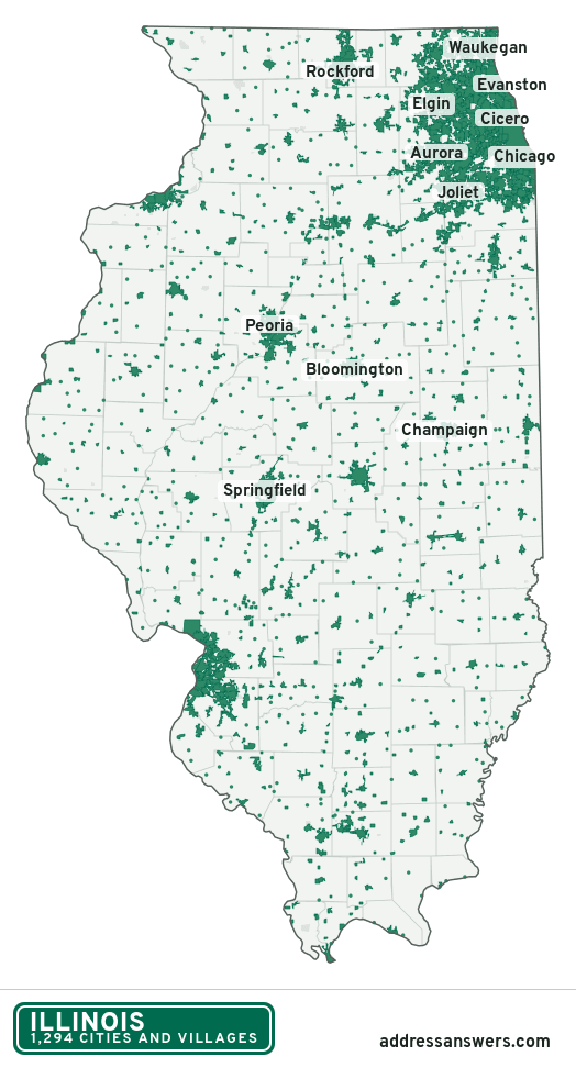
Illinois city limits map image
The map above as a picture: every Illinois city and town in green, with county lines. Boundaries from the Census Bureau, as of January 1, 2025.
You’re welcome to use it in a document or on your own site, with a link back to this page.
Download the map (PNG, 524 × 972)Questions about Illinois city limits
How many cities and villages are in Illinois?
Illinois has 1,294 incorporated places: 300 cities, 978 villages, and 16 towns, by the Census Bureau’s boundary files for 2025.
What is the largest city in Illinois?
By population, Chicago, with about 2.7 million residents (2020–2024 American Community Survey 5-year estimates). It is also the largest by land area, at 227.7 square miles.
What is the smallest village in Illinois?
By the Census Bureau’s estimate, Fults (tied with one other), with 12 residents. Estimates for places this small have a wide margin of error, so treat it as a rough count.
How much of Illinois is unincorporated?
92% of its land and 1.6 million of its residents (13%) are outside every city or village. There, local government is the township and the county. The state also has 167 named unincorporated communities; the largest is Gages Lake.
Is Gages Lake, IL a city?
No. Gages Lake is a census-designated place: a community the Census Bureau maps for statistics, with no city government of its own. About 10,819 people live there, in Lake County, in a township rather than a city. An address there is outside city limits, even if its mailing address says otherwise.
Is Frankfort Square, IL a city?
No. Frankfort Square is a census-designated place: a community the Census Bureau maps for statistics, with no city government of its own. About 9,560 people live there, in Will County, in a township rather than a city. An address there is outside city limits, even if its mailing address says otherwise.
Which cities and villages in Illinois are in more than one county?
101 of the 1,294 cross a county line, by at least 1% of their land. The largest: Aurora (Kane, DuPage, Will, and Kendall), Naperville (DuPage and Will), and Joliet (Will and Kendall). Check an address to see which county it’s in.
Which county in Illinois has the most cities and villages?
Cook County, with 130 at least partly inside it. Every county in Illinois has at least one.
Bordering states
More answers for a Illinois address
Each tool checks the same address and puts its own answer first.
- County Census Your county, plus the township or town where those exist. Find your county
- School district Census The public school district that covers the address. Find your school district
- Flood zone FEMA The FEMA zone in plain English, and whether lenders require flood insurance. Check flood zone
- USDA home loans USDA Whether the property is in an area eligible for a USDA Rural Development loan. Check USDA eligibility
- Voting districts Census Your congressional district and your state senate and state house districts. Included in every check
Places, boundaries, land area and counties: US Census Bureau 2025 cartographic boundary files (boundaries as of January 1, 2025). A place is listed in each county that holds at least 1% of its land. Population: 2020–2024 American Community Survey 5-year estimates. Data updated October 24, 2026; page updated October 25, 2026. Boundaries change through annexation; your city or county has the official map.