Indiana city limits map
Indiana has 566 incorporated places: 120 cities and 446 towns. They cover 7.7% of the state’s land and are home to 68% of its residents. Everyone else lives outside city limits, where local government is the township and the county. Enter an address to see which side of a city line it’s on.
Result for
The map couldn’t load. The answers don’t depend on it.
The boundary couldn’t load. The answer doesn’t depend on it.
Census Geocoder match
More about this address
Sources and limits
- Census
- US Census Bureau Geocoder, current boundaries
- FEMA
- National Flood Hazard Layer, effective flood maps
- USDA
- Rural Development property eligibility
- Map
- Boundaries from Census TIGERweb, flood zones drawn by FEMA, eligible areas from USDA, base map © OpenStreetMap contributors
Census boundaries are updated once a year, so a recent annexation may not show yet. Informational only, not an official determination. Verify with your city or county.
Indiana at a glance
- Incorporated places
- 566
- 120 cities and 446 towns
- Residents in city limits
- 68%
- 4,629,767 of 6,851,073
- Land in city limits
- 7.7%
- 2,752 of 35,825 sq mi
- Counties
- 92
- Every one has at least one
- Unincorporated communities
- 408
- Largest: Granger (30,321)
- Largest city
- Indianapolis
- 885,860 residents
How local government works in Indiana
Indiana is divided into 1,004 townships, and its cities and towns sit inside them. Each township has an elected trustee who, among other duties, runs township assistance for residents in need. Being in a township doesn’t make an address part of a city.
City limits maps for 6 Indiana cities
Every Indiana city with 100,000 or more residents has its own page: the boundary in detail, the places around it and its school districts.
All 566 cities and towns in Indiana
Every incorporated place, largest first, with the counties it’s in and its size. An address inside one of these is inside city limits; anywhere else in the state is unincorporated.
| Name | Type | County | Population | Land (sq mi) |
|---|---|---|---|---|
| Indianapolis | City | Marion | 885,860 | 361.0 |
| Fort Wayne | City | Allen | 268,589 | 111.8 |
| Evansville | City | Vanderburgh | 116,116 | 47.4 |
| South Bend | City | St. Joseph | 103,085 | 41.9 |
| Fishers | City | Hamilton | 102,337 | 36.6 |
| Carmel | City | Hamilton | 101,651 | 49.1 |
| Bloomington | City | Monroe | 80,049 | 23.2 |
| Hammond | City | Lake | 76,768 | 22.7 |
| Noblesville | City | Hamilton | 73,362 | 35.6 |
| Lafayette | City | Tippecanoe | 71,159 | 30.4 |
| Gary | City | Lake | 68,113 | 49.9 |
| Greenwood | City | Johnson | 66,029 | 28.8 |
| Muncie | City | Delaware | 64,751 | 27.4 |
| Kokomo | City | Howard | 59,122 | 37.5 |
| Terre Haute | City | Vigo | 58,427 | 34.8 |
| Anderson | City | Madison | 55,367 | 41.7 |
| Westfield | City | Hamilton | 54,677 | 33.0 |
| Elkhart | City | Elkhart | 53,733 | 28.5 |
| Columbus | City | Bartholomew | 51,824 | 30.0 |
| Jeffersonville | City | Clark | 51,043 | 34.1 |
| Mishawaka | City | St. Joseph | 51,021 | 18.2 |
| Lawrence | City | Marion | 49,517 | 20.2 |
| West Lafayette | City | Tippecanoe | 45,159 | 13.7 |
| Portage | City | Porter | 38,082 | 25.7 |
| New Albany | City | Floyd | 37,581 | 15.6 |
| Merrillville | Town | Lake | 36,476 | 33.2 |
| Plainfield | Town | Hendricks | 36,369 | 27.2 |
| Richmond | City | Wayne | 35,581 | 24.3 |
| Valparaiso | City | Porter | 34,733 | 17.4 |
| Goshen | City | Elkhart | 34,420 | 17.9 |
| Crown Point | City | Lake | 34,393 | 19.0 |
| Zionsville | Town | Boone | 32,095 | 67.2 |
| Michigan City | City | LaPorte | 31,814 | 20.6 |
| Brownsburg | Town | Hendricks | 31,215 | 17.1 |
| Schererville | Town | Lake | 29,701 | 15.1 |
| Hobart | City | Lake | 29,558 | 26.2 |
| Marion | City | Grant | 27,531 | 15.7 |
| Franklin | City | Johnson | 26,168 | 15.8 |
| East Chicago | City | Lake | 26,022 | 14.1 |
| Greenfield | City | Hancock | 24,940 | 14.2 |
| Munster | Town | Lake | 23,733 | 7.54 |
| Highland | Town | Lake | 23,680 | 6.93 |
| Avon | Town | Hendricks | 23,437 | 19.6 |
| St. John | Town | Lake | 22,567 | 13.0 |
| La Porte | City | LaPorte | 22,449 | 14.6 |
| Seymour | City | Jackson | 22,371 | 13.3 |
| Clarksville | Town | Clark | 22,016 | 10.1 |
| Shelbyville | City | Shelby | 20,296 | 13.8 |
| Lebanon | City | Boone | 17,812 | 21.4 |
| Logansport | City | Cass | 17,790 | 10.5 |
| New Castle | City | Henry | 17,367 | 7.33 |
| Huntington | City | Huntington | 17,030 | 9.44 |
| Warsaw | City | Kosciusko | 16,768 | 13.5 |
| Vincennes | City | Knox | 16,586 | 7.45 |
| Crawfordsville | City | Montgomery | 16,491 | 10.3 |
| Dyer | Town | Lake | 16,400 | 6.16 |
| Griffith | Town | Lake | 16,273 | 7.77 |
| Jasper | City | Dubois | 15,991 | 13.3 |
| Frankfort | City | Clinton | 15,917 | 9.84 |
| New Haven | City | Allen | 15,698 | 13.4 |
| Cedar Lake | Town | Lake | 15,295 | 9.45 |
| Beech Grove | City | Marion | 14,913 | 4.47 |
| Chesterton | Town | Porter | 14,446 | 9.44 |
| Speedway | Town | Marion | 13,968 | 4.79 |
| Bedford | City | Lawrence | 13,837 | 12.2 |
| Auburn | City | DeKalb | 13,565 | 8.72 |
| Lake Station | City | Lake | 13,185 | 8.29 |
| Connersville | City | Fayette | 13,109 | 7.77 |
| Whitestown | Town | Boone | 12,466 | 15.9 |
| Washington | City | Daviess | 12,367 | 6.67 |
| Greensburg | City | Decatur | 12,229 | 9.36 |
| Madison | City | Jefferson | 12,223 | 8.64 |
| Martinsville | City | Morgan | 11,933 | 9.17 |
| Danville | Town | Hendricks | 11,714 | 10.1 |
| Yorktown | Town | Delaware | 11,699 | 31.9 |
| Huntertown | Town | Allen | 11,379 | 8.28 |
| Lowell | Town | Lake | 11,073 | 7.02 |
| Peru | City | Miami | 10,901 | 5.06 |
| Bargersville | Town | Johnson | 10,752 | 18.7 |
| Plymouth | City | Marshall | 10,664 | 7.57 |
| Kendallville | City | Noble | 10,556 | 6.12 |
| Bluffton | City | Wells | 10,529 | 8.53 |
| Wabash | City | Wabash | 10,358 | 9.65 |
| McCordsville | Town | Hancock | 10,329 | 8.62 |
| Sellersburg | Town | Clark | 10,137 | 7.41 |
| Columbia City | City | Whitley | 9,897 | 5.62 |
| Greencastle | City | Putnam | 9,864 | 5.21 |
| Decatur | City | Adams | 9,811 | 6.10 |
| Mooresville | Town | Morgan | 9,751 | 6.71 |
| Angola | City | Steuben | 9,408 | 6.72 |
| Princeton | City | Gibson | 8,372 | 5.48 |
| Elwood | City | Madison | 8,356 | 4.00 |
| Charlestown | City | Clark | 8,294 | 11.4 |
| Brazil | City | Clay | 7,831 | 3.69 |
| Winfield | Town | Lake | 7,816 | 12.4 |
| Tell City | City | Perry | 7,505 | 4.53 |
| Scottsburg | City | Scott | 7,362 | 5.54 |
| Batesville | City | Ripley, Franklin | 7,282 | 6.15 |
| North Vernon | City | Jennings | 7,078 | 7.88 |
| Nappanee | City | Elkhart, Kosciusko | 6,815 | 4.93 |
| Boonville | City | Warrick | 6,702 | 5.73 |
| Ellettsville | Town | Monroe | 6,698 | 5.23 |
| Garrett | City | DeKalb | 6,642 | 4.25 |
| Salem | City | Washington | 6,489 | 4.22 |
| Portland | City | Jay | 6,416 | 4.87 |
| Mount Vernon | City | Posey | 6,400 | 2.88 |
| Huntingburg | City | Dubois | 6,396 | 5.05 |
| Cumberland | Town | Hancock, Marion | 6,267 | 3.18 |
| Rochester | City | Fulton | 6,215 | 4.57 |
| Gas City | City | Grant | 6,076 | 5.03 |
| Rushville | City | Rush | 6,036 | 3.39 |
| Hartford City | City | Blackford | 5,794 | 3.88 |
| New Whiteland | Town | Johnson | 5,704 | 1.45 |
| Rensselaer | City | Jasper | 5,573 | 7.15 |
| Cicero | Town | Hamilton | 5,509 | 1.63 |
| Monticello | City | White | 5,496 | 3.47 |
| Pendleton | Town | Madison | 5,321 | 13.5 |
| Winchester | City | Randolph | 5,284 | 3.46 |
| Tipton | City | Tipton | 5,280 | 2.74 |
| Westville | Town | LaPorte | 5,279 | 3.25 |
| Linton | City | Greene | 5,260 | 3.28 |
| Porter | Town | Porter | 5,217 | 6.18 |
| Lawrenceburg | City | Dearborn | 5,179 | 5.29 |
| Whiteland | Town | Johnson | 5,173 | 5.48 |
| Alexandria | City | Madison | 5,155 | 3.02 |
| Winona Lake | Town | Kosciusko | 5,080 | 2.95 |
| Fortville | Town | Hancock | 4,976 | 3.61 |
| North Manchester | Town | Wabash | 4,819 | 3.55 |
| Clinton | City | Vermillion | 4,794 | 2.25 |
| Bremen | Town | Marshall | 4,642 | 2.83 |
| Whiting | City | Lake | 4,532 | 1.81 |
| Edinburgh | Town | Johnson, Bartholomew +1 | 4,381 | 3.31 |
| Ligonier | City | Noble | 4,347 | 2.90 |
| Sullivan | City | Sullivan | 4,252 | 1.87 |
| DeMotte | Town | Jasper | 4,234 | 3.59 |
| Pittsboro | Town | Hendricks | 4,156 | 4.28 |
| Greendale | City | Dearborn | 3,986 | 5.66 |
| Chandler | Town | Warrick | 3,978 | 2.91 |
| Hebron | Town | Porter | 3,976 | 2.00 |
| Berne | City | Adams | 3,965 | 2.31 |
| Mitchell | City | Lawrence | 3,937 | 3.59 |
| Upland | Town | Grant | 3,918 | 3.14 |
| Austin | City | Scott | 3,818 | 3.18 |
| Georgetown | Town | Floyd | 3,800 | 2.18 |
| Middlebury | Town | Elkhart | 3,700 | 4.60 |
| Leo-Cedarville | Town | Allen | 3,695 | 3.72 |
| Aurora | City | Dearborn | 3,648 | 3.29 |
| Union City | City | Randolph | 3,569 | 2.26 |
| Hanover | Town | Jefferson | 3,554 | 2.22 |
| Knox | City | Starke | 3,479 | 3.96 |
| Newburgh | Town | Warrick | 3,395 | 1.49 |
| Ossian | Town | Wells | 3,384 | 1.90 |
| Attica | City | Fountain | 3,238 | 1.86 |
| Syracuse | Town | Kosciusko, Elkhart | 3,233 | 2.21 |
| New Palestine | Town | Hancock | 3,227 | 2.04 |
| Sheridan | Town | Hamilton | 3,205 | 48.3 |
| Corydon | Town | Harrison | 3,157 | 1.65 |
| Paoli | Town | Orange | 3,125 | 3.74 |
| Covington | City | Fountain | 3,069 | 1.52 |
| Brownstown | Town | Jackson | 3,040 | 1.62 |
| Fort Branch | Town | Gibson | 3,021 | 1.09 |
| Bicknell | City | Knox | 3,017 | 1.35 |
| Delphi | City | Carroll | 2,927 | 2.71 |
| Albany | Town | Delaware, Randolph | 2,907 | 1.98 |
| Avilla | Town | Noble | 2,878 | 1.72 |
| Loogootee | City | Martin | 2,853 | 1.56 |
| Santa Claus | Town | Spencer | 2,793 | 6.48 |
| Lagrange | Town | LaGrange | 2,790 | 1.79 |
| Centerville | Town | Wayne | 2,772 | 3.50 |
| Albion | Town | Noble | 2,723 | 1.91 |
| Bloomfield | Town | Greene | 2,713 | 1.41 |
| Lapel | Town | Madison | 2,668 | 10.4 |
| Fairmount | Town | Grant | 2,662 | 1.59 |
| Butler | City | DeKalb | 2,660 | 2.03 |
| Brookville | Town | Franklin | 2,643 | 1.40 |
| Osceola | Town | St. Joseph | 2,593 | 1.35 |
| Brooklyn | Town | Morgan | 2,570 | 0.99 |
| Rockville | Town | Parke | 2,559 | 1.49 |
| Ingalls | Town | Madison | 2,512 | 3.26 |
| Chesterfield | Town | Madison, Delaware | 2,489 | 1.37 |
| Spencer | Town | Owen | 2,481 | 1.72 |
| Rising Sun | City | Ohio | 2,474 | 1.50 |
| Winamac | Town | Pulaski | 2,473 | 1.36 |
| Petersburg | City | Pike | 2,414 | 1.58 |
| Kouts | Town | Porter | 2,372 | 1.21 |
| Fowler | Town | Benton | 2,360 | 1.41 |
| Ferdinand | Town | Dubois | 2,351 | 2.30 |
| Trail Creek | Town | LaPorte | 2,351 | 1.22 |
| Wakarusa | Town | Elkhart | 2,282 | 2.20 |
| Oakland City | City | Gibson | 2,262 | 1.13 |
| Knightstown | Town | Henry | 2,241 | 1.04 |
| Middletown | Town | Henry | 2,235 | 1.16 |
| Orleans | Town | Orange | 2,235 | 1.71 |
| New Chicago | Town | Lake | 2,225 | 0.67 |
| Cloverdale | Town | Putnam | 2,195 | 3.49 |
| Burns Harbor | Town | Porter | 2,155 | 6.44 |
| Bristol | Town | Elkhart | 2,128 | 5.74 |
| Edgewood | Town | Madison | 2,121 | 0.80 |
| Walkerton | Town | St. Joseph | 2,115 | 1.90 |
| Flora | Town | Carroll | 2,114 | 1.15 |
| Fremont | Town | Steuben | 2,112 | 3.11 |
| Greentown | Town | Howard | 2,094 | 1.38 |
| West Terre Haute | Town | Vigo | 2,092 | 0.75 |
| Monon | Town | White | 2,091 | 0.89 |
| Waterloo | Town | DeKalb | 2,073 | 2.11 |
| Monrovia | Town | Morgan | 2,055 | 1.93 |
| Liberty | Town | Union | 2,052 | 0.79 |
| Versailles | Town | Ripley | 2,037 | 1.57 |
| Hope | Town | Bartholomew | 2,029 | 0.95 |
| New Carlisle | Town | St. Joseph | 1,998 | 2.03 |
| Veedersburg | Town | Fountain | 1,990 | 3.00 |
| Jasonville | City | Greene | 1,979 | 1.27 |
| Southport | City | Marion | 1,975 | 0.63 |
| Battle Ground | Town | Tippecanoe | 1,969 | 1.02 |
| Rockport | City | Spencer | 1,958 | 1.66 |
| Milan | Town | Ripley | 1,942 | 1.99 |
| Roanoke | Town | Huntington | 1,940 | 1.24 |
| Hamilton | Town | Steuben, DeKalb | 1,939 | 2.10 |
| Shadeland | Town | Tippecanoe | 1,921 | 27.1 |
| Haubstadt | Town | Gibson | 1,905 | 0.71 |
| Williamsport | Town | Warren | 1,867 | 1.30 |
| Dunkirk | City | Jay, Blackford | 1,861 | 1.17 |
| French Lick | Town | Orange | 1,828 | 1.82 |
| Kentland | Town | Newton | 1,828 | 1.35 |
| North Judson | Town | Starke | 1,823 | 1.10 |
| Argos | Town | Marshall | 1,802 | 1.29 |
| North Liberty | Town | St. Joseph | 1,775 | 1.03 |
| Meridian Hills | Town | Marion | 1,767 | 1.48 |
| Bourbon | Town | Marshall | 1,760 | 1.15 |
| Churubusco | Town | Whitley | 1,757 | 1.05 |
| Vevay | Town | Switzerland | 1,757 | 1.45 |
| Crothersville | Town | Jackson | 1,720 | 1.16 |
| Dillsboro | Town | Dearborn | 1,697 | 1.35 |
| Milford | Town | Kosciusko | 1,661 | 1.50 |
| South Whitley | Town | Whitley | 1,660 | 0.85 |
| Frankton | Town | Madison | 1,658 | 1.06 |
| Cambridge City | Town | Wayne | 1,657 | 1.01 |
| Westport | Town | Decatur | 1,651 | 1.20 |
| Hagerstown | Town | Wayne | 1,642 | 1.32 |
| Osgood | Town | Ripley | 1,637 | 1.55 |
| Eaton | Town | Delaware | 1,630 | 3.73 |
| Remington | Town | Jasper | 1,623 | 3.81 |
| Warren Park | Town | Marion | 1,599 | 0.45 |
| Daleville | Town | Delaware | 1,584 | 2.13 |
| Jonesboro | City | Grant | 1,578 | 0.89 |
| Otterbein | Town | Tippecanoe, Benton | 1,576 | 1.28 |
| Greenville | Town | Floyd | 1,575 | 0.91 |
| Rossville | Town | Clinton | 1,565 | 0.46 |
| Arcadia | Town | Hamilton | 1,556 | 0.69 |
| Dale | Town | Spencer | 1,542 | 2.67 |
| Montpelier | City | Blackford | 1,533 | 1.50 |
| Brookston | Town | White | 1,530 | 0.66 |
| Oolitic | Town | Lawrence | 1,522 | 0.67 |
| Darmstadt | Town | Vanderburgh | 1,508 | 4.52 |
| Fairview Park | Town | Vermillion | 1,470 | 0.87 |
| Trafalgar | Town | Johnson | 1,469 | 2.56 |
| Clermont | Town | Marion | 1,468 | 0.67 |
| Pierceton | Town | Kosciusko | 1,451 | 1.25 |
| Russiaville | Town | Howard | 1,445 | 0.88 |
| Odon | Town | Daviess | 1,419 | 0.93 |
| Worthington | Town | Greene | 1,411 | 0.77 |
| Cannelton | City | Perry | 1,404 | 1.48 |
| Culver | Town | Marshall | 1,392 | 1.17 |
| Nashville | Town | Brown | 1,386 | 1.60 |
| New Pekin | Town | Washington | 1,372 | 2.38 |
| Galveston | Town | Cass | 1,363 | 0.58 |
| Kingsford Heights | Town | LaPorte | 1,358 | 0.89 |
| Geneva | Town | Adams | 1,347 | 1.10 |
| Redkey | Town | Jay | 1,332 | 0.87 |
| Morgantown | Town | Morgan | 1,308 | 0.38 |
| Gosport | Town | Owen | 1,303 | 0.38 |
| Farmland | Town | Randolph | 1,276 | 0.53 |
| Warren | Town | Huntington | 1,274 | 1.08 |
| Poseyville | Town | Posey | 1,270 | 0.65 |
| Mulberry | Town | Clinton | 1,265 | 0.53 |
| Shelburn | Town | Sullivan | 1,264 | 0.69 |
| Woodburn | City | Allen | 1,263 | 1.03 |
| Sunman | Town | Ripley | 1,247 | 1.17 |
| Ashley | Town | DeKalb, Steuben | 1,230 | 1.90 |
| Palmyra | Town | Harrison | 1,215 | 1.20 |
| Thorntown | Town | Boone | 1,212 | 0.71 |
| Parker City | Town | Randolph | 1,211 | 0.58 |
| Markle | Town | Huntington, Wells | 1,203 | 1.45 |
| Prince's Lakes | Town | Johnson | 1,188 | 1.34 |
| Rome City | Town | Noble | 1,182 | 1.47 |
| Wanatah | Town | LaPorte | 1,178 | 1.40 |
| Roseland | Town | St. Joseph | 1,175 | 0.38 |
| Dayton | Town | Tippecanoe | 1,168 | 1.15 |
| Farmersburg | Town | Sullivan | 1,166 | 0.74 |
| Owensville | Town | Gibson | 1,156 | 0.57 |
| Ladoga | Town | Montgomery | 1,144 | 0.54 |
| Wolcottville | Town | Noble, LaGrange | 1,143 | 1.01 |
| Ogden Dunes | Town | Porter | 1,140 | 0.74 |
| Topeka | Town | LaGrange | 1,137 | 1.61 |
| Morristown | Town | Shelby | 1,134 | 3.85 |
| Monroeville | Town | Allen | 1,122 | 0.78 |
| Oxford | Town | Benton | 1,113 | 0.55 |
| Long Beach | Town | LaPorte | 1,111 | 1.05 |
| Montgomery | Town | Daviess | 1,111 | 1.62 |
| Grabill | Town | Allen | 1,108 | 0.65 |
| Jamestown | Town | Boone, Hendricks | 1,107 | 1.05 |
| Clay City | Town | Clay | 1,104 | 0.54 |
| Summitville | Town | Madison | 1,104 | 0.57 |
| Millersburg | Town | Elkhart | 1,077 | 0.65 |
| Cayuga | Town | Vermillion | 1,064 | 1.01 |
| Sweetser | Town | Grant | 1,061 | 1.01 |
| Morocco | Town | Newton | 1,040 | 1.07 |
| Hamlet | Town | Starke | 1,039 | 0.97 |
| Andrews | Town | Huntington | 1,038 | 0.63 |
| Wolcott | Town | White | 1,033 | 0.59 |
| Utica | Town | Clark | 1,028 | 1.19 |
| Shirley | Town | Hancock, Henry | 1,022 | 0.36 |
| English | Town | Crawford | 1,008 | 3.04 |
| Borden | Town | Clark | 987 | 1.39 |
| Seelyville | Town | Vigo | 986 | 0.89 |
| Lynnville | Town | Warrick | 981 | 1.74 |
| Elberfeld | Town | Warrick | 971 | 0.31 |
| Roachdale | Town | Putnam | 971 | 0.51 |
| Akron | Town | Fulton | 954 | 0.54 |
| Francesville | Town | Pulaski | 946 | 0.30 |
| Lanesville | Town | Harrison | 944 | 0.94 |
| Lynn | Town | Randolph | 943 | 0.56 |
| Bunker Hill | Town | Miami | 940 | 0.39 |
| Hymera | Town | Sullivan | 937 | 0.71 |
| Marengo | Town | Crawford | 924 | 1.07 |
| Kirklin | Town | Clinton | 920 | 0.42 |
| Lyons | Town | Greene | 920 | 0.81 |
| Royal Center | Town | Cass | 919 | 0.57 |
| Colfax | Town | Clinton | 906 | 0.37 |
| Brook | Town | Newton | 900 | 0.68 |
| Fillmore | Town | Putnam | 895 | 1.95 |
| St. Paul | Town | Decatur, Shelby | 887 | 0.29 |
| Montezuma | Town | Parke | 881 | 0.61 |
| Dublin | Town | Wayne | 870 | 0.52 |
| North Webster | Town | Kosciusko | 866 | 0.81 |
| Oaktown | Town | Knox | 860 | 0.27 |
| Silver Lake | Town | Kosciusko | 857 | 0.54 |
| Homecroft | Town | Marion | 854 | 0.24 |
| Swayzee | Town | Grant | 846 | 0.47 |
| New Harmony | Town | Posey | 845 | 0.81 |
| Spiceland | Town | Henry | 840 | 1.44 |
| La Fontaine | Town | Wabash | 837 | 0.61 |
| Selma | Town | Delaware | 837 | 0.90 |
| Walton | Town | Cass | 827 | 0.43 |
| Shipshewana | Town | LaGrange | 822 | 1.36 |
| Clayton | Town | Hendricks | 818 | 0.65 |
| Medora | Town | Jackson | 817 | 0.30 |
| Atlanta | Town | Hamilton | 816 | 0.31 |
| Converse | Town | Miami, Grant | 813 | 0.99 |
| Waynetown | Town | Montgomery | 805 | 0.44 |
| Darlington | Town | Montgomery | 798 | 0.33 |
| Boswell | Town | Benton | 794 | 0.88 |
| Goodland | Town | Newton | 792 | 0.76 |
| Wheatfield | Town | Jasper | 792 | 0.59 |
| West Lebanon | Town | Warren | 789 | 0.62 |
| Dugger | Town | Sullivan | 783 | 0.59 |
| Van Buren | Town | Grant | 782 | 0.58 |
| Oldenburg | Town | Franklin | 770 | 0.43 |
| Mentone | Town | Kosciusko | 768 | 0.58 |
| Monroe City | Town | Knox | 767 | 0.27 |
| Milltown | Town | Crawford, Harrison | 763 | 1.33 |
| Winslow | Town | Pike | 759 | 0.69 |
| Grandview | Town | Spencer | 757 | 0.96 |
| North Salem | Town | Hendricks | 741 | 0.34 |
| Markleville | Town | Madison | 739 | 0.56 |
| Patoka | Town | Gibson | 737 | 1.19 |
| St. Leon | Town | Dearborn | 737 | 6.83 |
| Lakeville | Town | St. Joseph | 735 | 0.63 |
| Medaryville | Town | Pulaski | 729 | 0.46 |
| Carlisle | Town | Sullivan | 726 | 0.52 |
| Reynolds | Town | White | 718 | 0.55 |
| Cynthiana | Town | Posey | 716 | 0.40 |
| Mount Summit | Town | Henry | 713 | 0.21 |
| Gaston | Town | Delaware | 710 | 0.36 |
| Monroe | Town | Adams | 707 | 0.68 |
| Windfall City | Town | Tipton | 705 | 0.41 |
| Fountain City | Town | Wayne | 702 | 0.26 |
| Clarks Hill | Town | Tippecanoe | 700 | 0.27 |
| Kingman | Town | Fountain | 693 | 0.66 |
| Shoals | Town | Martin | 679 | 1.82 |
| Carthage | Town | Rush | 675 | 0.55 |
| Sharpsville | Town | Tipton | 662 | 0.23 |
| Fairland | Town | Shelby | 660 | 1.14 |
| Hillsboro | Town | Fountain | 656 | 0.31 |
| Dana | Town | Vermillion | 652 | 0.29 |
| Leesburg | Town | Kosciusko | 652 | 0.26 |
| La Crosse | Town | LaPorte | 651 | 0.57 |
| Beverly Shores | Town | Porter | 650 | 3.58 |
| Harmony | Town | Clay | 645 | 0.82 |
| Knightsville | Town | Clay | 642 | 1.04 |
| Campbellsburg | Town | Washington | 635 | 0.99 |
| Cromwell | Town | Noble | 631 | 0.33 |
| Rocky Ripple | Town | Marion | 631 | 0.30 |
| Moores Hill | Town | Dearborn | 629 | 0.43 |
| Pennville | Town | Jay | 619 | 0.50 |
| Holland | Town | Dubois | 613 | 0.37 |
| Hudson | Town | Steuben | 610 | 0.70 |
| Rosedale | Town | Parke | 609 | 0.39 |
| Troy | Town | Perry | 608 | 1.13 |
| Mecca | Town | Parke | 607 | 0.39 |
| Perrysville | Town | Vermillion | 607 | 0.26 |
| Bainbridge | Town | Putnam | 605 | 0.40 |
| West College Corner | Town | Union | 596 | 0.27 |
| Linden | Town | Montgomery | 590 | 0.39 |
| Richland | Town | Spencer | 588 | 0.51 |
| Camden | Town | Carroll | 585 | 0.26 |
| Ridgeville | Town | Randolph | 569 | 0.55 |
| Coatesville | Town | Hendricks | 566 | 0.65 |
| Burlington | Town | Carroll | 562 | 0.61 |
| Denver | Town | Miami | 553 | 0.24 |
| Lizton | Town | Hendricks | 543 | 0.73 |
| West Baden Springs | Town | Orange | 543 | 1.11 |
| Francisco | Town | Gibson | 537 | 0.61 |
| Paragon | Town | Morgan | 537 | 0.28 |
| Kewanna | Town | Fulton | 533 | 0.55 |
| Elnora | Town | Daviess | 531 | 0.98 |
| Town of Pines | Town | Porter | 530 | 2.25 |
| Chalmers | Town | White | 526 | 0.30 |
| Michigantown | Town | Clinton | 514 | 0.28 |
| New Market | Town | Montgomery | 509 | 0.27 |
| Holton | Town | Ripley | 502 | 1.81 |
| Matthews | Town | Grant | 501 | 0.35 |
| Mooreland | Town | Henry | 493 | 0.14 |
| Zanesville | Town | Wells, Allen | 488 | 0.83 |
| Roann | Town | Wabash | 479 | 0.23 |
| La Paz | Town | Marshall | 476 | 0.39 |
| Waveland | Town | Montgomery | 475 | 0.31 |
| Spring Grove | Town | Wayne | 464 | 0.30 |
| Clear Lake | Town | Steuben | 462 | 1.11 |
| Sulphur Springs | Town | Henry | 454 | 0.80 |
| Bruceville | Town | Knox | 446 | 0.34 |
| Laurel | Town | Franklin | 444 | 0.24 |
| Chrisney | Town | Spencer | 442 | 0.71 |
| Etna Green | Town | Kosciusko | 441 | 0.50 |
| Riley | Town | Vigo | 441 | 0.09 |
| Greens Fork | Town | Wayne | 436 | 0.14 |
| Orland | Town | Steuben | 434 | 0.69 |
| New Richmond | Town | Montgomery | 433 | 0.19 |
| Glenwood | Town | Rush, Fayette | 429 | 0.19 |
| Larwill | Town | Whitley | 425 | 0.18 |
| Amo | Town | Hendricks | 417 | 0.61 |
| Williams Creek | Town | Marion | 417 | 0.33 |
| Altona | Town | DeKalb | 415 | 0.20 |
| Kennard | Town | Henry | 415 | 0.42 |
| Plainville | Town | Daviess | 412 | 0.35 |
| St. Joe | Town | DeKalb | 411 | 0.34 |
| Leavenworth | Town | Crawford | 397 | 0.88 |
| Advance | Town | Boone | 390 | 0.60 |
| Wilkinson | Town | Hancock | 385 | 0.20 |
| Center Point | Town | Clay | 377 | 0.74 |
| Elizabethtown | Town | Bartholomew | 372 | 0.26 |
| Michiana Shores | Town | LaPorte | 364 | 0.35 |
| New Ross | Town | Montgomery | 364 | 0.30 |
| Staunton | Town | Clay | 350 | 0.33 |
| Wheatland | Town | Knox | 349 | 0.41 |
| Earl Park | Town | Benton | 342 | 0.92 |
| Sandborn | Town | Knox | 339 | 0.39 |
| Amboy | Town | Miami | 338 | 0.34 |
| Edwardsport | Town | Knox | 337 | 0.28 |
| Lagro | Town | Wabash | 330 | 0.59 |
| Newport | Town | Vermillion | 330 | 0.87 |
| Bloomingdale | Town | Parke | 324 | 0.58 |
| Milton | Town | Wayne | 323 | 0.27 |
| Claypool | Town | Kosciusko | 318 | 0.24 |
| Uniondale | Town | Wells | 309 | 0.21 |
| Russellville | Town | Putnam | 308 | 0.20 |
| Burnettsville | Town | White | 307 | 0.75 |
| Switz City | Town | Greene | 306 | 0.20 |
| Gentryville | Town | Spencer | 303 | 0.39 |
| Stinesville | Town | Monroe | 297 | 0.11 |
| Stilesville | Town | Hendricks | 296 | 0.37 |
| Wingate | Town | Montgomery | 296 | 0.22 |
| Dune Acres | Town | Porter | 293 | 2.13 |
| Merom | Town | Sullivan | 285 | 0.36 |
| West Harrison | Town | Dearborn | 285 | 0.22 |
| Lewisville | Town | Henry | 282 | 0.28 |
| Dupont | Town | Jefferson | 279 | 1.01 |
| Hartsville | Town | Bartholomew | 277 | 0.32 |
| Marshall | Town | Parke | 266 | 0.26 |
| Birdseye | Town | Dubois | 263 | 0.64 |
| Crane | Town | Martin | 260 | 0.12 |
| Bryant | Town | Jay | 258 | 0.32 |
| Fulton | Town | Fulton | 256 | 0.19 |
| Cedar Grove | Town | Franklin | 252 | 0.15 |
| Saratoga | Town | Randolph | 249 | 0.26 |
| Pottawattamie Park | Town | LaPorte | 247 | 0.25 |
| Boston | Town | Wayne | 246 | 0.22 |
| Orestes | Town | Madison | 243 | 0.47 |
| Somerville | Town | Gibson | 243 | 0.36 |
| Pine Village | Town | Warren | 239 | 0.12 |
| Carbon | Town | Clay | 238 | 0.15 |
| Losantville | Town | Randolph | 238 | 0.19 |
| Yeoman | Town | Carroll | 235 | 0.13 |
| Crandall | Town | Harrison | 233 | 0.10 |
| Schneider | Town | Lake | 230 | 0.86 |
| East Germantown | Town | Wayne | 229 | 0.12 |
| Straughn | Town | Henry | 229 | 0.14 |
| Millhousen | Town | Decatur | 227 | 0.90 |
| Cadiz | Town | Henry | 226 | 0.14 |
| Kempton | Town | Tipton | 225 | 0.16 |
| Spring Lake | Town | Hancock | 224 | 0.15 |
| Salamonia | Town | Jay | 218 | 0.73 |
| Shamrock Lakes | Town | Blackford | 217 | 0.26 |
| Kingsbury | Town | LaPorte | 210 | 0.59 |
| Wynnedale | Town | Marion | 210 | 0.16 |
| Little York | Town | Washington | 208 | 0.98 |
| Napoleon | Town | Ripley | 205 | 0.24 |
| Dunreith | Town | Henry | 204 | 0.12 |
| Burket | Town | Kosciusko | 203 | 0.07 |
| Onward | Town | Cass | 202 | 0.10 |
| New Point | Town | Decatur | 201 | 0.31 |
| Newtown | Town | Fountain | 200 | 0.50 |
| Macy | Town | Miami | 199 | 0.11 |
| Hazleton | Town | Gibson | 196 | 0.35 |
| Mellott | Town | Fountain | 195 | 0.34 |
| Vernon | Town | Jennings | 193 | 0.21 |
| Country Club Heights | Town | Madison | 189 | 0.28 |
| Fowlerton | Town | Grant | 185 | 0.20 |
| Patriot | Town | Switzerland | 183 | 0.28 |
| Modoc | Town | Randolph | 180 | 0.10 |
| Cannelburg | Town | Daviess | 178 | 0.21 |
| Greensboro | Town | Henry | 178 | 0.11 |
| Decker | Town | Knox | 174 | 0.19 |
| Poneto | Town | Wells | 174 | 0.11 |
| Universal | Town | Vermillion | 173 | 0.36 |
| Blountsville | Town | Henry | 170 | 0.11 |
| Elizabeth | Town | Harrison | 168 | 0.26 |
| Clifford | Town | Bartholomew | 165 | 0.09 |
| Tennyson | Town | Warrick | 165 | 0.23 |
| Spurgeon | Town | Pike | 163 | 0.18 |
| Ambia | Town | Benton | 158 | 0.15 |
| Springport | Town | Henry | 154 | 0.12 |
| Ulen | Town | Boone | 152 | 0.23 |
| Griffin | Town | Posey | 148 | 0.07 |
| Economy | Town | Wayne | 144 | 0.09 |
| Monterey | Town | Pulaski | 143 | 0.18 |
| Wallace | Town | Fountain | 140 | 0.14 |
| Jonesville | Town | Bartholomew | 129 | 0.15 |
| Corunna | Town | DeKalb | 128 | 0.18 |
| Sidney | Town | Kosciusko | 123 | 0.13 |
| Newberry | Town | Greene | 121 | 0.48 |
| Saltillo | Town | Washington | 117 | 1.15 |
| Mount Etna | Town | Huntington | 112 | 0.12 |
| Brooksburg | Town | Jefferson | 111 | 0.10 |
| Crows Nest | Town | Marion | 109 | 0.43 |
| State Line City | Town | Warren | 103 | 0.14 |
| Indian Village | Town | St. Joseph | 97 | 0.09 |
| Livonia | Town | Washington | 95 | 1.04 |
| New Amsterdam | Town | Harrison | 92 | 0.08 |
| Mount Ayr | Town | Newton | 90 | 0.18 |
| Mackey | Town | Gibson | 88 | 0.09 |
| Mount Auburn | Town | Wayne | 88 | 0.19 |
| North Crows Nest | Town | Marion | 75 | 0.06 |
| Spring Hill | Town | Marion | 74 | 0.11 |
| Whitewater | Town | Wayne | 74 | 0.08 |
| Woodlawn Heights | Town | Madison | 72 | 0.11 |
| Bethany | Town | Morgan | 67 | 0.09 |
| Vera Cruz | Town | Wells | 62 | 0.10 |
| Mount Carmel | Town | Franklin | 60 | 0.04 |
| New Middletown | Town | Harrison | 55 | 0.03 |
| Mauckport | Town | Harrison | 49 | 0.20 |
| Laconia | Town | Harrison | 47 | 0.05 |
| Alamo | Town | Montgomery | 45 | 0.06 |
| Alton | Town | Crawford | 37 | 0.17 |
| Alfordsville | Town | Daviess | 25 | 0.07 |
| River Forest | Town | Madison | 21 | 0.02 |
Showing 1–50 of 566
Unincorporated communities in Indiana
Census-designated places: named communities the Census Bureau maps for statistics, with no city government of their own. An address in one is outside city limits, even when its mailing address names a city. Indiana has 408.
| Community | County | Population | Land (sq mi) |
|---|---|---|---|
| Granger | St. Joseph | 30,321 | 24.5 |
| Lakes of the Four Seasons | Lake | 7,402 | 2.28 |
| South Haven | Porter | 7,241 | 2.27 |
| Notre Dame | St. Joseph | 6,890 | 1.18 |
| Ross | Lake | 6,751 | 5.67 |
| Dunlap | Elkhart | 6,109 | 4.91 |
| Hidden Valley | Dearborn | 5,706 | 4.24 |
| Bright | Dearborn | 5,540 | 12.5 |
| Highland | Vanderburgh | 5,114 | 2.27 |
| North Terre Haute | Vigo | 4,534 | 3.58 |
| Floyds Knobs | Floyd | 4,515 | 6.41 |
| Simonton Lake | Elkhart | 4,248 | 3.37 |
| Roselawn | Newton | 3,417 | 6.07 |
| Smithville-Sanders | Monroe | 3,299 | 10.7 |
| Shorewood Forest | Porter | 3,263 | 1.90 |
| Melody Hill | Vanderburgh | 3,243 | 1.37 |
| Heritage Lake | Putnam | 3,227 | 3.01 |
| Country Squire Lakes | Jennings | 3,057 | 2.56 |
| Grissom AFB | Miami | 2,977 | 4.00 |
| Putnamville | Putnam | 1,959 | 2.07 |
| Salt Creek Commons | Porter | 1,843 | 0.37 |
| Ardmore | St. Joseph | 1,810 | 1.51 |
| Henryville | Clark | 1,691 | 2.83 |
| Foxcliff Estates | Morgan | 1,674 | 2.06 |
| Galena | Floyd | 1,549 | 2.67 |
| New Paris | Elkhart | 1,549 | 1.55 |
| Aberdeen | Porter | 1,490 | 1.26 |
| Barbee | Kosciusko | 1,464 | 1.07 |
| Hudson Lake | LaPorte | 1,347 | 1.92 |
| Harlan | Allen | 1,254 | 3.48 |
| Taylorsville | Bartholomew | 1,248 | 1.06 |
| Cordry Sweetwater Lakes | Brown | 1,190 | 2.68 |
| Koontz Lake | Starke | 1,182 | 3.52 |
| Lake Dalecarlia | Lake | 1,169 | 1.13 |
| Howe | LaGrange | 1,092 | 1.79 |
| Palestine | Kosciusko | 1,085 | 1.02 |
| Gilmer Park | St. Joseph | 1,055 | 0.46 |
| Enchanted Hills | Kosciusko | 1,039 | 1.11 |
| Tri-Lakes | Whitley | 1,025 | 3.42 |
| Jimmerson Lake | Steuben | 1,024 | 1.72 |
| Bass Lake | Starke | 983 | 8.71 |
| Waverly | Morgan | 967 | 1.52 |
| St. Mary of the Woods | Vigo | 959 | 1.24 |
| Underwood | Clark | 957 | 2.57 |
| Painted Hills | Morgan | 948 | 1.73 |
| Buffalo | White | 947 | 2.37 |
| St. Wendel | Posey | 923 | 1.70 |
| Mexico | Miami | 906 | 5.49 |
| Hoagland | Allen | 845 | 3.40 |
| Lake Holiday | Montgomery | 845 | 2.59 |
| Pleasant Lake | Steuben | 829 | 0.65 |
| Lake Santee | Decatur | 820 | 2.46 |
| Belleville | Hendricks | 813 | 1.11 |
| Freelandville | Knox | 807 | 5.56 |
| Memphis | Clark | 784 | 2.60 |
| Rockford | Jackson | 761 | 0.85 |
| Mineral Springs | Bartholomew | 742 | 0.40 |
| San Pierre | Starke | 727 | 0.60 |
| Lake Village | Newton | 705 | 3.94 |
| Fish Lake | LaPorte | 684 | 1.54 |
| Arlington | Rush | 678 | 0.80 |
| Wadesville | Posey | 672 | 1.14 |
| Lake of the Woods | Marshall | 663 | 0.69 |
| Browns Crossing | Morgan | 658 | 0.45 |
| Van Bibber Lake | Putnam | 658 | 0.26 |
| St. Meinrad | Spencer | 646 | 1.68 |
| Tecumseh | Vigo | 638 | 2.59 |
| Pleasant View Village | Bartholomew | 625 | 0.20 |
| Pleasant View | Shelby | 611 | 0.42 |
| Everton | Fayette | 610 | 0.94 |
| Waldron | Shelby | 606 | 1.26 |
| Center | Howard | 605 | 0.90 |
| Parkers Settlement | Posey | 605 | 1.75 |
| Kimmell | Noble | 604 | 0.96 |
| Boggstown | Shelby | 597 | 0.36 |
| Morris | Ripley | 587 | 0.66 |
| Westwood | Henry | 584 | 0.64 |
| Lakewood | Vigo | 568 | 0.28 |
| Lewis | Vigo | 560 | 0.27 |
| Nineveh | Johnson | 559 | 0.79 |
| St. Bernice | Vermillion | 554 | 1.28 |
| Lake Eliza | Porter | 545 | 0.48 |
| Hanna | LaPorte | 529 | 0.98 |
| New Goshen | Vigo | 526 | 0.47 |
| Milroy | Rush | 522 | 0.66 |
| Snow Lake | Steuben | 519 | 0.60 |
| Williamsburg | Wayne | 510 | 0.31 |
| New Salisbury | Harrison | 499 | 1.98 |
| Hatfield | Spencer | 497 | 1.17 |
| Metamora | Franklin | 491 | 0.41 |
| Chain-O-Lakes | St. Joseph | 490 | 1.54 |
| Delaware | Ripley | 489 | 1.81 |
| Prairieton | Vigo | 475 | 0.48 |
| Stanford | Monroe | 472 | 1.76 |
| Reo | Spencer | 465 | 2.39 |
| Laketon | Wabash | 460 | 1.05 |
| Owensburg | Greene | 447 | 1.85 |
| Big Lake | Noble | 445 | 0.58 |
| Avoca | Lawrence | 439 | 2.10 |
| Dubois | Dubois | 439 | 1.57 |
| Ramsey | Harrison | 439 | 1.23 |
| Lyford | Parke | 438 | 1.02 |
| Philadelphia | Hancock | 431 | 0.34 |
| Celestine | Dubois | 422 | 0.42 |
| Maxwell | Hancock | 413 | 0.73 |
| Vallonia | Jackson | 411 | 0.76 |
| Miami | Miami | 409 | 0.16 |
| Idaville | White | 399 | 5.84 |
| Anoka | Cass | 398 | 0.23 |
| Charlottesville | Hancock | 398 | 0.63 |
| Cloverland | Clay | 398 | 0.59 |
| Linn Grove | Adams | 396 | 0.21 |
| Bethel Village | Bartholomew | 393 | 0.13 |
| Romney | Tippecanoe | 391 | 0.36 |
| Liberty Center | Wells | 389 | 1.36 |
| Nyona Lake | Fulton | 389 | 0.38 |
| Helmsburg | Brown | 387 | 1.26 |
| Star City | Pulaski | 386 | 0.69 |
| Benton | Elkhart | 384 | 0.95 |
| Hoffman Lake | Kosciusko | 382 | 0.70 |
| Johnson | Gibson | 379 | 1.99 |
| Otwell | Pike | 379 | 1.78 |
| Tippecanoe | Marshall | 378 | 0.61 |
| Lake Everett | Allen | 368 | 0.57 |
| Shipshewana Lake | LaGrange | 365 | 0.33 |
| Patricksburg | Owen | 356 | 0.49 |
| Wolflake | Noble | 353 | 1.65 |
| New Washington | Clark | 351 | 5.21 |
| Manchester | Dearborn | 343 | 1.49 |
| Wellsboro | LaPorte | 343 | 0.18 |
| Grammer | Bartholomew | 336 | 0.25 |
| Walesboro | Bartholomew | 331 | 0.23 |
| Saline City | Clay | 329 | 0.15 |
| Manilla | Rush | 328 | 0.23 |
| Fair Oaks | Jasper | 323 | 0.26 |
| Amity | Johnson | 317 | 0.66 |
| Hartz Lake | Starke | 312 | 0.42 |
| Herbst | Grant | 309 | 0.14 |
| Needmore | Lawrence | 309 | 0.64 |
| Fairview | Randolph | 306 | 0.53 |
| Ontario | LaGrange | 301 | 0.78 |
| Twelve Mile | Cass | 300 | 0.64 |
| Arthur | Pike | 299 | 0.69 |
| Harrodsburg | Monroe | 298 | 4.31 |
| Coalmont | Clay | 297 | 1.50 |
| Royerton | Delaware | 295 | 0.51 |
| New Trenton | Franklin | 290 | 0.46 |
| Hayden | Jennings | 288 | 2.47 |
| Adams Lake | LaGrange | 286 | 0.41 |
| Stockwell | Tippecanoe | 286 | 0.54 |
| Lake Holiday Hideaway | Fountain | 284 | 0.53 |
| South Milford | LaGrange | 284 | 0.68 |
| Oswego | Kosciusko | 283 | 0.47 |
| Wheeler | Porter | 283 | 2.66 |
| Norway | White | 282 | 0.89 |
| Blanford | Vermillion | 281 | 0.42 |
| Brimfield | Noble | 281 | 0.61 |
| New Lebanon | Sullivan | 281 | 0.15 |
| Cassville | Howard | 279 | 0.83 |
| Goldsmith | Tipton | 279 | 0.21 |
| Freetown | Jackson | 277 | 0.69 |
| Marion | Shelby | 276 | 0.34 |
| Lamb | Switzerland | 272 | 0.60 |
| Paxton | Sullivan | 269 | 0.56 |
| Merriam | Noble | 268 | 0.99 |
| Carrollton | Hancock | 267 | 1.07 |
| Haysville | Dubois | 267 | 1.36 |
| Tocsin | Wells | 266 | 0.47 |
| Geneva | Shelby | 265 | 0.31 |
| Hessen Cassel | Allen | 261 | 1.12 |
| Forest | Clinton | 259 | 0.23 |
| Toad Hop | Vigo | 257 | 0.15 |
| Mongo | LaGrange | 246 | 0.39 |
| Scipio | Jennings | 246 | 1.15 |
| Spencerville | DeKalb | 244 | 1.22 |
| Andersonville | Franklin | 238 | 0.37 |
| Rolling Prairie | LaPorte | 238 | 1.06 |
| Stroh | LaGrange | 238 | 0.35 |
| Hillsdale | Vermillion | 237 | 0.54 |
| Huron | Lawrence | 237 | 0.40 |
| Green Hill | Warren | 234 | 0.47 |
| Homer | Rush | 233 | 0.23 |
| Martinsburg | Washington | 233 | 0.45 |
| Union Mills | LaPorte | 233 | 0.61 |
| Butlerville | Jennings | 231 | 0.37 |
| Hortonville | Hamilton | 229 | 0.28 |
| Schaefer Lake | Bartholomew | 229 | 0.22 |
| New Marion | Ripley | 227 | 0.35 |
| East Enterprise | Switzerland | 226 | 0.47 |
| Young America | Cass | 225 | 0.14 |
| Brownsville | Union | 222 | 0.25 |
| Somerset | Wabash | 221 | 0.68 |
| Laotto | Noble | 220 | 0.47 |
| Saugany Lake | LaPorte | 217 | 0.70 |
| Eminence | Morgan | 216 | 0.30 |
| Otter Lake | Steuben | 216 | 0.50 |
| Blue Ridge | Shelby | 215 | 0.44 |
| Thayer | Newton | 212 | 0.62 |
| Alford | Pike | 210 | 0.30 |
| Mier | Grant | 210 | 0.24 |
| Newbern | Bartholomew | 210 | 0.99 |
| Groveland | Putnam | 209 | 1.11 |
| Bowling Green | Clay | 207 | 0.50 |
| New London | Howard | 207 | 0.36 |
| Stewartsville | Posey | 206 | 0.25 |
| Oakville | Delaware | 205 | 0.26 |
| Blairsville | Posey | 203 | 1.25 |
| St. Anthony | Dubois | 203 | 0.50 |
| Arcola | Allen | 201 | 0.37 |
| Pittsburg | Carroll | 201 | 0.26 |
| Sandusky | Decatur | 200 | 0.22 |
| Tyner | Marshall | 200 | 0.40 |
| Williams | Lawrence | 200 | 1.82 |
| Grandview Lake | Bartholomew | 199 | 0.52 |
| Reddington | Jackson | 199 | 0.86 |
| Gwynneville | Shelby | 198 | 0.22 |
| Prairie Creek | Vigo | 198 | 0.22 |
| Hillisburg | Clinton | 194 | 0.08 |
| Fishersburg | Madison | 190 | 0.16 |
| West Point | Tippecanoe | 189 | 0.39 |
| Glezen | Pike | 185 | 0.88 |
| West Middleton | Howard | 185 | 0.42 |
| Solsberry | Greene | 184 | 0.91 |
| Deer Creek | Carroll | 183 | 0.14 |
| Leiters Ford | Fulton | 183 | 0.63 |
| Wall Lake | LaGrange | 181 | 0.54 |
| Billtown | Clay | 177 | 0.42 |
| Rob Roy | Fountain | 177 | 0.63 |
| Abington | Wayne | 175 | 0.34 |
| Cree Lake | Noble | 173 | 0.64 |
| Bretzville | Dubois | 172 | 1.10 |
| Eugene | Vermillion | 170 | 0.46 |
| Roll | Blackford | 169 | 0.84 |
| Willow Branch | Hancock | 167 | 0.07 |
| Hardinsburg | Washington | 164 | 2.03 |
| Shelby | Lake | 164 | 1.29 |
| Vicksburg | Greene | 164 | 0.34 |
| Lake Bruce | Fulton | 163 | 0.59 |
| Peppertown | Franklin | 162 | 0.42 |
| Coal City | Owen | 161 | 0.36 |
| Midland | Greene | 159 | 0.64 |
| Judah | Lawrence | 157 | 1.18 |
| Stendal | Pike | 155 | 0.37 |
| Coesse | Whitley | 154 | 0.66 |
| Letts | Decatur | 154 | 0.15 |
| Ireland | Dubois | 153 | 0.28 |
| Newtonville | Spencer | 151 | 0.73 |
| Leopold | Perry | 150 | 0.32 |
| Talma | Fulton | 150 | 0.20 |
| Canton | Washington | 148 | 0.44 |
| Fairbanks | Sullivan | 147 | 0.17 |
| Lincoln | Cass | 147 | 0.15 |
| Bear Lake | Noble | 144 | 0.20 |
| Harrison Lake | Bartholomew | 144 | 0.27 |
| Rockfield | Carroll | 144 | 0.37 |
| Beaver Dam | Kosciusko | 143 | 0.41 |
| Sumava Resorts | Newton | 143 | 0.99 |
| Bennetts Switch | Miami | 141 | 0.40 |
| Libertyville | Vigo | 141 | 0.15 |
| Lucerne | Cass | 141 | 0.09 |
| Burns City | Martin | 139 | 0.73 |
| Commiskey | Jennings | 139 | 0.63 |
| Duneland Beach | LaPorte | 139 | 0.19 |
| Liberty Mills | Wabash | 139 | 0.60 |
| Raglesville | Daviess | 139 | 0.85 |
| Bridgeton | Parke | 138 | 0.39 |
| Burrows | Carroll | 138 | 0.38 |
| Malden | Porter | 137 | 0.71 |
| Scott | LaGrange | 137 | 0.42 |
| Centerton | Morgan | 136 | 0.12 |
| Petersville | Bartholomew | 134 | 0.15 |
| Stone Bluff | Fountain | 134 | 0.16 |
| Hemlock | Howard | 132 | 0.36 |
| Webster | Wayne | 132 | 0.33 |
| Folsomville | Warrick | 130 | 0.32 |
| Sardinia | Decatur | 130 | 0.13 |
| Antioch | Clinton | 129 | 0.35 |
| Pleasantville | Sullivan | 127 | 0.37 |
| Grayford | Jennings | 124 | 0.20 |
| Pleasant Mills | Adams | 124 | 0.32 |
| Adams | Decatur | 121 | 0.17 |
| Flat Rock | Shelby | 121 | 0.35 |
| Canaan | Jefferson | 120 | 0.28 |
| Fountaintown | Shelby | 119 | 0.88 |
| Judyville | Warren | 118 | 0.13 |
| Blooming Grove | Franklin | 117 | 0.98 |
| Urbana | Wabash | 116 | 0.22 |
| Waynesville | Bartholomew | 116 | 0.08 |
| Wildwood | Steuben | 116 | 0.18 |
| Shepardsville | Vigo | 115 | 0.92 |
| Servia | Wabash | 114 | 0.25 |
| Eckerty | Crawford | 112 | 1.20 |
| Groverton | Starke | 111 | 0.86 |
| Cory | Clay | 109 | 0.21 |
| Middlebury | Clay | 109 | 0.32 |
| Otisco | Clark | 109 | 0.40 |
| Cutler | Carroll | 108 | 0.43 |
| South Center | LaPorte | 108 | 0.90 |
| Mays | Rush | 103 | 0.16 |
| Burnett | Vigo | 101 | 0.42 |
| Laud | Whitley | 101 | 0.67 |
| Foster | Warren | 100 | 1.29 |
| Mariah Hill | Spencer | 100 | 1.01 |
| Bringhurst | Carroll | 98 | 0.14 |
| Sims | Grant | 98 | 0.29 |
| Marietta | Shelby | 97 | 0.38 |
| Raub | Benton | 97 | 0.09 |
| Warrington | Hancock | 97 | 0.16 |
| Ora | Starke | 96 | 0.53 |
| Prospect | Orange | 96 | 0.87 |
| Schnellville | Dubois | 95 | 1.15 |
| Colburn | Tippecanoe | 92 | 0.10 |
| Hobbs | Tipton | 92 | 0.83 |
| Vistula | Elkhart | 90 | 1.59 |
| Cowan | Delaware | 89 | 0.36 |
| Preble | Adams | 88 | 0.19 |
| Ragsdale | Knox | 88 | 0.90 |
| Scircleville | Clinton | 88 | 0.32 |
| Hashtown | Greene | 87 | 0.34 |
| Riverwood | Hamilton | 87 | 0.08 |
| Cross Plains | Ripley | 86 | 0.48 |
| Leroy | Lake | 85 | 0.22 |
| Wawaka | Noble | 85 | 0.76 |
| Mace | Montgomery | 84 | 0.23 |
| Buckskin | Gibson | 83 | 0.67 |
| Holiday Woods | Steuben | 83 | 0.23 |
| Poland | Clay | 81 | 0.52 |
| Cates | Fountain | 80 | 0.20 |
| Wyatt | St. Joseph | 80 | 1.00 |
| New Lisbon | Henry | 79 | 0.23 |
| Perkinsville | Madison | 79 | 0.14 |
| Buck Creek | Tippecanoe | 77 | 0.12 |
| Clarksburg | Decatur | 76 | 0.39 |
| Emison | Knox | 76 | 1.57 |
| Montmorenci | Tippecanoe | 76 | 0.25 |
| Spartanburg | Randolph | 76 | 0.28 |
| Bippus | Huntington | 75 | 0.21 |
| Dover Hill | Martin | 71 | 0.78 |
| Wooster | Kosciusko | 70 | 0.30 |
| Millgrove | Blackford | 69 | 0.20 |
| Americus | Tippecanoe | 67 | 0.23 |
| Graysville | Sullivan | 67 | 0.15 |
| Milford | Decatur | 67 | 0.12 |
| Grantsburg | Crawford | 66 | 0.76 |
| Cass | Sullivan | 65 | 0.22 |
| Craigville | Wells | 65 | 0.16 |
| Keystone | Wells | 65 | 0.88 |
| Kramer | Warren | 64 | 0.35 |
| Tunnelton | Lawrence | 64 | 0.56 |
| Fontanet | Vigo | 63 | 1.03 |
| Donaldson | Marshall | 62 | 0.49 |
| Marshfield | Warren | 62 | 0.16 |
| Centenary | Vermillion | 60 | 0.29 |
| Point Isabel | Grant | 60 | 0.57 |
| Cartersburg | Hendricks | 59 | 0.31 |
| Paris Crossing | Jennings | 59 | 0.81 |
| Florence | Switzerland | 58 | 0.13 |
| Velpen | Pike | 57 | 0.33 |
| Linnsburg | Montgomery | 56 | 0.38 |
| Scotland | Greene | 53 | 0.58 |
| Jalapa | Grant | 52 | 0.57 |
| Chili | Miami | 48 | 0.20 |
| Fredericksburg | Washington | 48 | 1.08 |
| Westphalia | Knox | 47 | 0.45 |
| Maples | Allen | 44 | 0.22 |
| Pierceville | Ripley | 43 | 0.55 |
| Depauw | Harrison | 42 | 0.37 |
| Lawrenceport | Lawrence | 38 | 0.55 |
| Azalia | Bartholomew | 37 | 0.12 |
| Deputy | Jefferson | 37 | 0.07 |
| Elizaville | Boone | 35 | 0.48 |
| Teegarden | Marshall | 35 | 0.10 |
| Petroleum | Wells | 34 | 0.08 |
| Jerome | Howard | 33 | 0.22 |
| Pulaski | Pulaski | 33 | 0.46 |
| Judson | Parke | 32 | 0.08 |
| Helmer | Steuben | 31 | 0.11 |
| Boone Grove | Porter | 30 | 0.27 |
| London | Shelby | 30 | 0.36 |
| Lakeshore Resort | Franklin | 29 | 0.38 |
| Cortland | Jackson | 28 | 0.75 |
| Dresser | Vigo | 27 | 0.15 |
| Hamburg | Franklin | 25 | 0.19 |
| Taswell | Crawford | 25 | 0.56 |
| Lake View | Franklin | 23 | 0.70 |
| East Oolitic | Lawrence | 22 | 0.44 |
| Landess | Grant | 22 | 1.41 |
| Eden | Hancock | 20 | 0.17 |
| Independence | Warren | 20 | 0.19 |
| St. Omer | Decatur | 19 | 0.25 |
| Templeton | Benton | 15 | 0.12 |
| Metz | Steuben | 12 | 0.08 |
| Stillwell | LaPorte | 12 | 0.54 |
| Heltonville | Lawrence | 11 | 0.33 |
| Elrod | Ripley | 10 | 0.70 |
| Hedrick | Warren | 10 | 0.04 |
| Millville | Henry | 8 | 0.13 |
| North Grove | Miami | 8 | 0.13 |
| Rainsville | Warren | 6 | 0.21 |
| Blocher | Scott | 0 | 0.71 |
| Burney | Decatur | 0 | 0.08 |
| Kent | Jefferson | 0 | 0.07 |
| Lake Cicott | Cass | 0 | 0.42 |
| Needham | Johnson | 0 | 0.03 |
| Pence | Warren | 0 | 0.17 |
| Penntown | Ripley | 0 | 0.55 |
| Tab | Warren | 0 | 0.23 |
| Windsor | Delaware | 0 | 0.25 |
Showing 1–50 of 408
Counties in Indiana
92 counties, with how many cities and towns have land in each and the largest whose main county it is.
| County | Cities | Largest | Population | Land (sq mi) |
|---|---|---|---|---|
| Marion County | 16 | Indianapolis | 975,809 | 396.0 |
| Lake County | 19 | Hammond | 500,379 | 498.9 |
| Allen County | 8 | Fort Wayne | 392,378 | 657.1 |
| Hamilton County | 8 | Fishers | 365,056 | 394.4 |
| St. Joseph County | 9 | South Bend | 273,040 | 457.8 |
| Elkhart County | 8 | Elkhart | 207,132 | 463.2 |
| Tippecanoe County | 7 | Lafayette | 189,071 | 498.9 |
| Hendricks County | 12 | Plainfield | 183,344 | 406.9 |
| Vanderburgh County | 2 | Evansville | 180,117 | 233.4 |
| Porter County | 11 | Portage | 174,818 | 418.1 |
| Johnson County | 8 | Greenwood | 166,315 | 320.4 |
| Monroe County | 3 | Bloomington | 140,965 | 394.5 |
| Madison County | 15 | Anderson | 131,900 | 451.9 |
| Clark County | 6 | Jeffersonville | 124,354 | 372.5 |
| Delaware County | 8 | Muncie | 112,280 | 392.1 |
| LaPorte County | 11 | Michigan City | 111,917 | 598.3 |
| Vigo County | 4 | Terre Haute | 106,109 | 403.6 |
| Hancock County | 8 | Greenfield | 84,037 | 306.0 |
| Howard County | 3 | Kokomo | 83,752 | 293.1 |
| Bartholomew County | 7 | Columbus | 83,536 | 406.9 |
| Floyd County | 3 | New Albany | 80,918 | 148.5 |
| Kosciusko County | 14 | Warsaw | 80,442 | 531.4 |
| Boone County | 7 | Zionsville | 74,718 | 422.9 |
| Morgan County | 7 | Martinsville | 72,659 | 403.8 |
| Wayne County | 14 | Richmond | 66,397 | 401.8 |
| Grant County | 11 | Marion | 66,295 | 414.1 |
| Warrick County | 6 | Boonville | 65,261 | 384.6 |
| Dearborn County | 7 | Lawrenceburg | 51,094 | 305.1 |
| Henry County | 16 | New Castle | 48,970 | 391.9 |
| Noble County | 7 | Kendallville | 47,495 | 410.8 |
| Jackson County | 4 | Seymour | 46,660 | 510.0 |
| Marshall County | 6 | Plymouth | 46,284 | 443.6 |
| Shelby County | 5 | Shelbyville | 45,265 | 411.1 |
| Lawrence County | 3 | Bedford | 45,102 | 449.1 |
| DeKalb County | 9 | Auburn | 43,807 | 362.8 |
| Dubois County | 5 | Jasper | 43,614 | 427.3 |
| LaGrange County | 4 | Lagrange | 40,805 | 379.6 |
| Harrison County | 10 | Corydon | 39,859 | 484.1 |
| Montgomery County | 11 | Crawfordsville | 38,312 | 504.6 |
| Cass County | 5 | Logansport | 37,680 | 412.1 |
| Putnam County | 6 | Greencastle | 37,280 | 480.5 |
| Huntington County | 6 | Huntington | 36,798 | 382.6 |
| Adams County | 4 | Decatur | 36,227 | 338.9 |
| Knox County | 9 | Vincennes | 36,007 | 515.8 |
| Miami County | 6 | Peru | 35,712 | 373.8 |
| Steuben County | 7 | Angola | 34,726 | 308.8 |
| Whitley County | 4 | Columbia City | 34,618 | 335.6 |
| Daviess County | 7 | Washington | 33,658 | 429.5 |
| Jasper County | 4 | Rensselaer | 33,234 | 559.7 |
| Gibson County | 10 | Princeton | 33,000 | 487.4 |
| Jefferson County | 4 | Madison | 32,998 | 360.7 |
| Clinton County | 6 | Frankfort | 32,944 | 405.1 |
| Greene County | 7 | Linton | 31,021 | 542.5 |
| Wabash County | 5 | Wabash | 30,844 | 412.5 |
| Ripley County | 7 | Batesville | 29,095 | 446.4 |
| Wells County | 7 | Bluffton | 28,420 | 368.1 |
| Washington County | 6 | Salem | 28,212 | 513.7 |
| Jennings County | 2 | North Vernon | 27,562 | 376.6 |
| Decatur County | 5 | Greensburg | 26,422 | 372.6 |
| Clay County | 7 | Brazil | 26,409 | 357.6 |
| Posey County | 5 | Mount Vernon | 25,116 | 409.4 |
| White County | 7 | Monticello | 24,717 | 505.2 |
| Scott County | 2 | Scottsburg | 24,526 | 190.4 |
| Randolph County | 10 | Winchester | 24,387 | 452.4 |
| Starke County | 3 | Knox | 23,365 | 309.1 |
| Fayette County | 2 | Connersville | 23,334 | 215.0 |
| Franklin County | 6 | Brookville | 23,020 | 384.4 |
| Owen County | 2 | Spencer | 21,604 | 385.3 |
| Sullivan County | 7 | Sullivan | 20,780 | 447.2 |
| Carroll County | 5 | Delphi | 20,535 | 372.2 |
| Fulton County | 4 | Rochester | 20,312 | 368.4 |
| Jay County | 6 | Portland | 20,229 | 383.9 |
| Spencer County | 7 | Santa Claus | 19,955 | 396.9 |
| Orange County | 4 | Paoli | 19,767 | 398.4 |
| Perry County | 3 | Tell City | 19,270 | 381.7 |
| Rush County | 3 | Rushville | 16,739 | 408.1 |
| Fountain County | 8 | Attica | 16,617 | 395.7 |
| Parke County | 6 | Rockville | 16,406 | 444.7 |
| Brown County | 1 | Nashville | 15,606 | 312.0 |
| Vermillion County | 7 | Clinton | 15,421 | 256.9 |
| Tipton County | 4 | Tipton | 15,346 | 260.5 |
| Newton County | 5 | Kentland | 13,922 | 401.8 |
| Pulaski County | 4 | Winamac | 12,441 | 433.7 |
| Pike County | 3 | Petersburg | 12,154 | 334.4 |
| Blackford County | 4 | Hartford City | 11,950 | 165.1 |
| Crawford County | 5 | English | 10,499 | 305.6 |
| Switzerland County | 2 | Vevay | 9,909 | 220.7 |
| Martin County | 3 | Loogootee | 9,830 | 335.8 |
| Benton County | 6 | Fowler | 8,735 | 406.4 |
| Warren County | 4 | Williamsport | 8,464 | 364.7 |
| Union County | 2 | Liberty | 6,985 | 161.2 |
| Ohio County | 1 | Rising Sun | 5,999 | 86.1 |
Showing 1–50 of 92
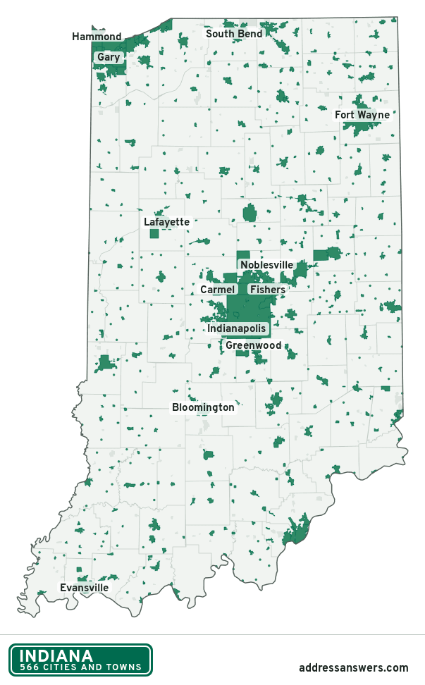
Indiana city limits map image
The map above as a picture: every Indiana city and town in green, with county lines. Boundaries from the Census Bureau, as of January 1, 2025.
You’re welcome to use it in a document or on your own site, with a link back to this page.
Download the map (PNG, 603 × 972)Questions about Indiana city limits
How many cities and towns are in Indiana?
Indiana has 566 incorporated places: 120 cities and 446 towns, by the Census Bureau’s boundary files for 2025.
What is the largest city in Indiana?
By population, Indianapolis, with about 885,860 residents (2020–2024 American Community Survey 5-year estimates). It is also the largest by land area, at 361.0 square miles.
What is the smallest town in Indiana?
By the Census Bureau’s estimate, River Forest, with 21 residents. Estimates for places this small have a wide margin of error, so treat it as a rough count.
How much of Indiana is unincorporated?
92% of its land and 2.2 million of its residents (32%) are outside every city or town. There, local government is the township and the county. The state also has 408 named unincorporated communities; the largest is Granger.
Is Granger, IN a city?
No. Granger is a census-designated place: a community the Census Bureau maps for statistics, with no city government of its own. About 30,321 people live there, in St. Joseph County, in a township rather than a city. An address there is outside city limits, even if its mailing address says otherwise.
Is Lakes of the Four Seasons, IN a city?
No. Lakes of the Four Seasons is a census-designated place: a community the Census Bureau maps for statistics, with no city government of its own. About 7,402 people live there, in Lake County, in a township rather than a city. An address there is outside city limits, even if its mailing address says otherwise.
Which cities and towns in Indiana are in more than one county?
20 of the 566 cross a county line, by at least 1% of their land. The largest: Batesville (Ripley and Franklin), Nappanee (Elkhart and Kosciusko), and Cumberland (Hancock and Marion). Check an address to see which county it’s in.
Which county in Indiana has the most cities and towns?
Lake County, with 19 at least partly inside it. Every county in Indiana has at least one.
Bordering states
More answers for a Indiana address
Each tool checks the same address and puts its own answer first.
- County Census Your county, plus the township or town where those exist. Find your county
- School district Census The public school district that covers the address. Find your school district
- Flood zone FEMA The FEMA zone in plain English, and whether lenders require flood insurance. Check flood zone
- USDA home loans USDA Whether the property is in an area eligible for a USDA Rural Development loan. Check USDA eligibility
- Voting districts Census Your congressional district and your state senate and state house districts. Included in every check
Places, boundaries, land area and counties: US Census Bureau 2025 cartographic boundary files (boundaries as of January 1, 2025). A place is listed in each county that holds at least 1% of its land. Population: 2020–2024 American Community Survey 5-year estimates. Data updated October 24, 2026; page updated October 25, 2026. Boundaries change through annexation; your city or county has the official map.