Ohio city limits map
Ohio has 925 incorporated places: 253 cities and 672 villages. They cover 9.5% of the state’s land and are home to 65% of its residents. Everyone else lives outside city limits, where local government is the township and the county. Enter an address to see which side of a city line it’s on.
Result for
The map couldn’t load. The answers don’t depend on it.
The boundary couldn’t load. The answer doesn’t depend on it.
Census Geocoder match
More about this address
Sources and limits
- Census
- US Census Bureau Geocoder, current boundaries
- FEMA
- National Flood Hazard Layer, effective flood maps
- USDA
- Rural Development property eligibility
- Map
- Boundaries from Census TIGERweb, flood zones drawn by FEMA, eligible areas from USDA, base map © OpenStreetMap contributors
Census boundaries are updated once a year, so a recent annexation may not show yet. Informational only, not an official determination. Verify with your city or county.
Ohio at a glance
- Incorporated places
- 925
- 253 cities and 672 villages
- Residents in city limits
- 65%
- 7,682,318 of 11,810,293
- Land in city limits
- 9.5%
- 3,901 of 40,859 sq mi
- Counties
- 88
- Every one has at least one
- Unincorporated communities
- 340
- Largest: Austintown (30,164)
- Largest city
- Columbus
- 914,802 residents
How local government works in Ohio
The Census Bureau maps 1,321 townships in Ohio. Each township has elected trustees and a fiscal officer, and many provide roads, zoning and fire protection. A township isn’t a city, so an address in one is outside city limits unless it’s also inside a city.
City limits maps for 6 Ohio cities
Every Ohio city with 100,000 or more residents has its own page: the boundary in detail, the places around it and its school districts.
All 925 cities and villages in Ohio
Every incorporated place, largest first, with the counties it’s in and its size. An address inside one of these is inside city limits; anywhere else in the state is unincorporated.
| Name | Type | County | Population | Land (sq mi) |
|---|---|---|---|---|
| Columbus | City | Franklin, Delaware | 914,802 | 221.9 |
| Cleveland | City | Cuyahoga | 366,097 | 77.7 |
| Cincinnati | City | Hamilton | 311,224 | 77.9 |
| Toledo | City | Lucas | 267,463 | 80.5 |
| Akron | City | Summit | 189,247 | 61.9 |
| Dayton | City | Montgomery | 136,579 | 55.8 |
| Parma | City | Cuyahoga | 79,870 | 20.0 |
| Canton | City | Stark | 69,755 | 26.3 |
| Lorain | City | Lorain | 65,395 | 23.6 |
| Hamilton | City | Butler | 63,468 | 21.5 |
| Youngstown | City | Mahoning, Trumbull | 59,331 | 33.9 |
| Springfield | City | Clark | 58,190 | 26.6 |
| Kettering | City | Montgomery, Greene | 57,206 | 18.7 |
| Elyria | City | Lorain | 53,035 | 20.5 |
| Middletown | City | Butler, Warren | 51,617 | 26.3 |
| Cuyahoga Falls | City | Summit | 50,909 | 25.8 |
| Newark | City | Licking | 50,783 | 21.0 |
| Lakewood | City | Cuyahoga | 50,007 | 5.56 |
| Dublin | City | Franklin, Union +1 | 49,294 | 24.7 |
| Euclid | City | Cuyahoga | 48,823 | 10.7 |
| Mansfield | City | Richland | 47,663 | 30.9 |
| Mentor | City | Lake | 47,171 | 27.8 |
| Beavercreek | City | Greene | 47,126 | 26.6 |
| Strongsville | City | Cuyahoga | 45,983 | 24.6 |
| Fairfield | City | Butler | 44,828 | 20.8 |
| Delaware | City | Delaware | 44,589 | 20.4 |
| Cleveland Heights | City | Cuyahoga | 44,497 | 8.07 |
| Huber Heights | City | Montgomery, Miami | 43,455 | 22.7 |
| Grove City | City | Franklin | 42,517 | 18.9 |
| Lancaster | City | Fairfield | 41,249 | 19.1 |
| Reynoldsburg | City | Franklin, Licking +1 | 41,224 | 11.3 |
| Findlay | City | Hancock | 40,287 | 19.9 |
| Warren | City | Trumbull | 38,912 | 16.0 |
| Westerville | City | Franklin, Delaware | 38,645 | 12.6 |
| Hilliard | City | Franklin | 38,033 | 14.2 |
| North Ridgeville | City | Lorain | 36,627 | 23.4 |
| Upper Arlington | City | Franklin | 36,293 | 9.81 |
| Marion | City | Marion | 35,669 | 13.0 |
| Mason | City | Warren | 35,509 | 19.5 |
| Gahanna | City | Franklin | 35,486 | 12.4 |
| Brunswick | City | Medina | 35,246 | 13.0 |
| Lima | City | Allen | 35,010 | 13.6 |
| Fairborn | City | Greene | 34,534 | 14.6 |
| Stow | City | Summit | 34,240 | 17.1 |
| Westlake | City | Cuyahoga | 34,104 | 15.9 |
| Massillon | City | Stark | 32,338 | 18.9 |
| North Olmsted | City | Cuyahoga | 31,924 | 11.7 |
| North Royalton | City | Cuyahoga | 30,972 | 21.4 |
| Bowling Green | City | Wood | 29,983 | 13.1 |
| Garfield Heights | City | Cuyahoga | 29,269 | 7.23 |
| Shaker Heights | City | Cuyahoga | 28,922 | 6.29 |
| Marysville | City | Union | 27,518 | 17.6 |
| Green | City | Summit | 27,393 | 32.0 |
| Kent | City | Portage | 27,116 | 9.46 |
| Wooster | City | Wayne | 26,971 | 17.5 |
| Troy | City | Miami | 26,842 | 12.6 |
| Medina | City | Medina | 25,950 | 11.6 |
| Avon Lake | City | Lorain | 25,752 | 11.1 |
| Xenia | City | Greene | 25,689 | 13.1 |
| Avon | City | Lorain | 25,317 | 20.8 |
| Centerville | City | Montgomery, Greene | 25,205 | 11.0 |
| Perrysburg | City | Wood | 25,181 | 12.1 |
| Barberton | City | Summit | 24,844 | 9.02 |
| Zanesville | City | Muskingum | 24,740 | 11.8 |
| Sandusky | City | Erie | 24,606 | 9.64 |
| Wadsworth | City | Medina | 24,492 | 11.5 |
| Pickerington | City | Fairfield, Franklin | 24,477 | 10.2 |
| Riverside | City | Montgomery | 24,435 | 9.73 |
| Willoughby | City | Lake | 24,046 | 10.2 |
| Solon | City | Cuyahoga | 23,943 | 20.3 |
| Athens | City | Athens | 23,396 | 9.95 |
| Maple Heights | City | Cuyahoga | 23,258 | 5.17 |
| Trotwood | City | Montgomery | 23,041 | 30.5 |
| Hudson | City | Summit | 23,039 | 25.6 |
| Chillicothe | City | Ross | 21,902 | 10.5 |
| Oxford | City | Butler | 21,753 | 7.78 |
| South Euclid | City | Cuyahoga | 21,534 | 4.66 |
| Lebanon | City | Warren | 21,501 | 13.5 |
| Rocky River | City | Cuyahoga | 21,490 | 4.73 |
| Alliance | City | Stark, Mahoning | 21,478 | 9.01 |
| Piqua | City | Miami | 20,646 | 13.2 |
| Parma Heights | City | Cuyahoga | 20,581 | 4.20 |
| Painesville | City | Lake | 20,548 | 6.83 |
| Sidney | City | Shelby | 20,501 | 12.0 |
| Forest Park | City | Hamilton | 20,025 | 6.45 |
| Mayfield Heights | City | Cuyahoga | 20,022 | 4.17 |
| Whitehall | City | Franklin | 20,019 | 5.29 |
| Springboro | City | Warren, Montgomery | 19,980 | 9.24 |
| Miamisburg | City | Montgomery | 19,948 | 12.3 |
| Oregon | City | Lucas | 19,799 | 28.5 |
| Broadview Heights | City | Cuyahoga | 19,771 | 13.0 |
| Twinsburg | City | Summit | 19,410 | 13.8 |
| Norwood | City | Hamilton | 19,114 | 3.14 |
| Sylvania | City | Lucas | 19,055 | 6.67 |
| Ashland | City | Ashland | 18,911 | 11.4 |
| Tallmadge | City | Summit, Portage | 18,335 | 14.1 |
| Niles | City | Trumbull | 18,287 | 8.65 |
| Brook Park | City | Cuyahoga | 18,284 | 7.52 |
| Pataskala | City | Licking | 18,223 | 29.0 |
| Berea | City | Cuyahoga | 18,218 | 5.68 |
| Steubenville | City | Jefferson | 18,124 | 10.5 |
| Ashtabula | City | Ashtabula | 17,856 | 7.70 |
| Tiffin | City | Seneca | 17,818 | 7.38 |
| Portsmouth | City | Scioto | 17,728 | 10.7 |
| North Canton | City | Stark | 17,727 | 6.43 |
| Streetsboro | City | Portage | 17,661 | 23.4 |
| Aurora | City | Portage | 17,581 | 23.0 |
| New Philadelphia | City | Tuscarawas | 17,520 | 8.18 |
| Eastlake | City | Lake | 17,493 | 6.41 |
| Defiance | City | Defiance | 17,276 | 12.9 |
| Norwalk | City | Huron | 17,095 | 8.85 |
| Mount Vernon | City | Knox | 17,052 | 9.92 |
| Fairview Park | City | Cuyahoga | 17,018 | 4.69 |
| Bay Village | City | Cuyahoga | 15,984 | 4.57 |
| Fremont | City | Sandusky | 15,835 | 8.74 |
| Middleburg Heights | City | Cuyahoga | 15,786 | 8.06 |
| Monroe | City | Butler, Warren | 15,401 | 15.8 |
| Vandalia | City | Montgomery | 15,053 | 12.3 |
| Worthington | City | Franklin | 14,938 | 5.47 |
| Powell | City | Delaware | 14,451 | 5.83 |
| Washington Court House | City | Fayette | 14,439 | 9.04 |
| Willowick | City | Lake | 14,162 | 2.54 |
| Circleville | City | Pickaway | 14,142 | 7.30 |
| Sharonville | City | Hamilton, Butler | 14,030 | 9.81 |
| Beachwood | City | Cuyahoga | 13,865 | 5.26 |
| New Franklin | City | Summit | 13,843 | 25.0 |
| Bellefontaine | City | Logan | 13,807 | 10.2 |
| Lyndhurst | City | Cuyahoga | 13,801 | 4.43 |
| Maumee | City | Lucas | 13,715 | 10.1 |
| Brecksville | City | Cuyahoga | 13,692 | 19.4 |
| Trenton | City | Butler | 13,583 | 4.94 |
| Warrensville Heights | City | Cuyahoga | 13,545 | 4.12 |
| East Cleveland | City | Cuyahoga | 13,534 | 3.08 |
| Blue Ash | City | Hamilton | 13,455 | 7.58 |
| University Heights | City | Cuyahoga | 13,394 | 1.83 |
| Englewood | City | Montgomery | 13,356 | 6.56 |
| Clayton | City | Montgomery | 13,277 | 18.5 |
| Marietta | City | Washington | 13,203 | 8.43 |
| Loveland | City | Hamilton, Clermont +1 | 13,197 | 5.30 |
| Bexley | City | Franklin | 13,114 | 2.42 |
| Harrison | City | Hamilton | 13,084 | 5.34 |
| Dover | City | Tuscarawas | 13,053 | 5.75 |
| West Carrollton | City | Montgomery | 12,976 | 6.43 |
| Bedford | City | Cuyahoga | 12,931 | 5.34 |
| Amherst | City | Lorain | 12,906 | 7.08 |
| Greenville | City | Darke | 12,741 | 6.58 |
| Wickliffe | City | Lake | 12,659 | 4.61 |
| Wilmington | City | Clinton | 12,620 | 12.9 |
| Conneaut | City | Ashtabula | 12,357 | 26.3 |
| Fostoria | City | Seneca, Hancock +1 | 12,344 | 7.57 |
| Macedonia | City | Summit | 12,152 | 9.73 |
| Salem | City | Columbiana, Mahoning | 11,758 | 6.57 |
| Franklin | City | Warren | 11,712 | 9.41 |
| Seven Hills | City | Cuyahoga | 11,603 | 4.90 |
| Bucyrus | City | Crawford | 11,594 | 7.39 |
| Norton | City | Summit | 11,524 | 20.2 |
| Ravenna | City | Portage | 11,274 | 5.62 |
| Urbana | City | Champaign | 11,204 | 8.33 |
| Brooklyn | City | Cuyahoga | 11,158 | 4.25 |
| Coshocton | City | Coshocton | 11,068 | 8.00 |
| Springdale | City | Hamilton | 11,033 | 4.98 |
| Celina | City | Mercer | 10,903 | 5.04 |
| New Albany | City | Franklin, Licking | 10,896 | 21.7 |
| Montgomery | City | Hamilton | 10,855 | 5.31 |
| Bedford Heights | City | Cuyahoga | 10,847 | 4.55 |
| Van Wert | City | Van Wert | 10,790 | 7.53 |
| Ironton | City | Lawrence | 10,768 | 4.47 |
| Heath | City | Licking | 10,644 | 11.5 |
| Richmond Heights | City | Cuyahoga | 10,626 | 4.43 |
| Reading | City | Hamilton | 10,502 | 2.89 |
| London | City | Madison | 10,484 | 8.40 |
| Tipp City | City | Miami | 10,439 | 8.20 |
| Vermilion | City | Lorain, Erie | 10,343 | 10.6 |
| Galion | City | Crawford, Richland +1 | 10,339 | 7.43 |
| Canal Winchester | City | Franklin, Fairfield | 10,170 | 8.12 |
| Cambridge | City | Guernsey | 10,060 | 6.37 |
| Willoughby Hills | City | Lake | 9,975 | 10.8 |
| Struthers | City | Mahoning | 9,923 | 3.64 |
| Wapakoneta | City | Auglaize | 9,894 | 6.69 |
| East Liverpool | City | Columbiana | 9,783 | 4.70 |
| Louisville | City | Stark | 9,602 | 5.67 |
| North College Hill | City | Hamilton | 9,555 | 1.82 |
| Girard | City | Trumbull | 9,505 | 5.64 |
| Madeira | City | Hamilton | 9,484 | 3.35 |
| Oakwood | City | Montgomery | 9,458 | 2.19 |
| Sheffield Lake | City | Lorain | 8,966 | 2.49 |
| Shelby | City | Richland | 8,865 | 6.33 |
| Napoleon | City | Henry | 8,802 | 6.21 |
| Wyoming | City | Hamilton | 8,723 | 2.88 |
| Cheviot | City | Hamilton | 8,660 | 1.17 |
| Grandview Heights | City | Franklin | 8,647 | 1.32 |
| Olmsted Falls | City | Cuyahoga | 8,639 | 4.08 |
| Bryan | City | Williams | 8,631 | 5.40 |
| Highland Heights | City | Cuyahoga | 8,623 | 5.15 |
| Orrville | City | Wayne | 8,343 | 5.61 |
| Eaton | City | Preble | 8,339 | 6.43 |
| Oberlin | City | Lorain | 8,329 | 4.92 |
| St. Marys | City | Auglaize | 8,301 | 4.67 |
| Bellevue | City | Huron, Sandusky +1 | 8,187 | 6.13 |
| Sunbury | City | Delaware | 8,005 | 7.14 |
| Campbell | City | Mahoning | 7,784 | 3.72 |
| Fairlawn | City | Summit | 7,711 | 4.56 |
| Kenton | City | Hardin | 7,663 | 4.99 |
| Canfield | City | Mahoning | 7,649 | 5.10 |
| Hubbard | City | Trumbull | 7,598 | 4.03 |
| Independence | City | Cuyahoga | 7,534 | 9.53 |
| Wauseon | City | Fulton | 7,505 | 5.32 |
| Bellbrook | City | Greene | 7,394 | 3.14 |
| Obetz | City | Franklin | 7,330 | 5.82 |
| Delphos | City | Allen, Van Wert | 7,143 | 3.32 |
| Mentor-on-the-Lake | City | Lake | 7,111 | 1.61 |
| Cortland | City | Trumbull | 7,080 | 4.33 |
| Union | City | Montgomery, Miami | 7,037 | 8.49 |
| Logan | City | Hocking | 6,993 | 4.79 |
| Mount Healthy | City | Hamilton | 6,919 | 1.50 |
| Kirtland | City | Lake | 6,911 | 16.7 |
| Columbiana | City | Columbiana, Mahoning | 6,903 | 6.11 |
| Pepper Pike | City | Cuyahoga | 6,840 | 7.12 |
| Huron | City | Erie | 6,757 | 4.94 |
| South Lebanon | City | Warren | 6,712 | 3.48 |
| Ontario | City | Richland | 6,667 | 11.1 |
| Belpre | City | Washington | 6,654 | 3.48 |
| Upper Sandusky | City | Wyandot | 6,558 | 6.75 |
| Moraine | City | Montgomery | 6,536 | 9.28 |
| Hillsboro | City | Highland | 6,527 | 5.47 |
| Milford | City | Clermont, Hamilton | 6,497 | 3.71 |
| Clyde | City | Sandusky | 6,331 | 5.25 |
| Rossford | City | Wood | 6,323 | 5.17 |
| Jackson | City | Jackson | 6,231 | 9.05 |
| Willard | City | Huron | 6,164 | 3.58 |
| Martins Ferry | City | Belmont | 6,140 | 2.33 |
| The Village of Indian Hill | City | Hamilton | 6,052 | 19.5 |
| Rittman | City | Wayne, Medina | 6,044 | 6.30 |
| Waterville | City | Lucas | 6,017 | 5.18 |
| Granville | Village | Licking | 5,999 | 4.87 |
| Port Clinton | City | Ottawa | 5,970 | 2.13 |
| Groveport | City | Franklin | 5,900 | 8.71 |
| Geneva | City | Ashtabula | 5,886 | 4.00 |
| Germantown | City | Montgomery | 5,825 | 4.22 |
| Brookville | City | Montgomery | 5,779 | 4.10 |
| Grafton | Village | Lorain | 5,657 | 4.93 |
| New Carlisle | City | Clark | 5,544 | 2.68 |
| Carlisle | City | Warren, Montgomery | 5,543 | 3.56 |
| Wellston | City | Jackson | 5,452 | 6.97 |
| Reminderville | City | Summit | 5,387 | 2.18 |
| Deer Park | City | Hamilton | 5,384 | 0.85 |
| Canal Fulton | City | Stark | 5,337 | 3.69 |
| Toronto | City | Jefferson | 5,293 | 2.09 |
| Johnstown | City | Licking | 5,286 | 2.98 |
| Chardon | City | Geauga | 5,249 | 4.39 |
| Northwood | City | Wood | 5,193 | 8.56 |
| Uhrichsville | City | Tuscarawas | 5,189 | 2.81 |
| St. Clairsville | City | Belmont | 5,003 | 2.42 |
| Munroe Falls | City | Summit | 5,000 | 2.77 |
| Mount Orab | Village | Brown | 4,987 | 9.68 |
| Silverton | Village | Hamilton | 4,860 | 1.11 |
| Ottawa Hills | Village | Lucas | 4,798 | 1.88 |
| Ada | Village | Hardin | 4,797 | 2.13 |
| Lexington | Village | Richland | 4,774 | 4.13 |
| West Milton | Village | Miami | 4,771 | 3.39 |
| East Palestine | Village | Columbiana | 4,696 | 3.15 |
| Ashville | Village | Pickaway | 4,648 | 2.48 |
| Whitehouse | Village | Lucas | 4,642 | 4.32 |
| Wellington | Village | Lorain | 4,593 | 3.64 |
| Newton Falls | Village | Trumbull | 4,549 | 2.96 |
| Blanchester | Village | Clinton | 4,538 | 4.09 |
| New Lexington | Village | Perry | 4,519 | 1.95 |
| Crestline | Village | Crawford, Richland | 4,470 | 3.39 |
| Ottawa | Village | Putnam | 4,441 | 4.55 |
| Archbold | Village | Fulton | 4,397 | 4.94 |
| West Jefferson | Village | Madison | 4,392 | 10.1 |
| Sheffield | Village | Lorain | 4,380 | 10.7 |
| Nelsonville | City | Athens | 4,279 | 4.68 |
| Chagrin Falls | Village | Cuyahoga | 4,201 | 2.08 |
| Coldwater | Village | Mercer | 4,191 | 1.94 |
| New Lebanon | Village | Montgomery | 4,169 | 2.04 |
| Sebring | Village | Mahoning | 4,146 | 2.50 |
| Waverly | Village | Pike | 4,127 | 4.16 |
| Swanton | Village | Fulton, Lucas | 4,098 | 3.40 |
| Cedarville | Village | Greene | 4,070 | 1.31 |
| St. Bernard | Village | Hamilton | 3,983 | 1.53 |
| Greenfield | Village | Highland, Ross | 3,966 | 2.08 |
| South Russell | Village | Geauga | 3,956 | 3.81 |
| Barnesville | Village | Belmont | 3,945 | 2.05 |
| Montpelier | Village | Williams | 3,905 | 2.87 |
| Georgetown | Village | Brown | 3,899 | 4.18 |
| Woodlawn | Village | Hamilton | 3,894 | 2.56 |
| Bluffton | Village | Allen, Hancock | 3,859 | 3.69 |
| Plain City | Village | Madison, Union | 3,829 | 3.32 |
| Amberley | Village | Hamilton | 3,826 | 3.48 |
| Mogadore | Village | Summit, Portage | 3,806 | 2.14 |
| Bellaire | Village | Belmont | 3,800 | 1.65 |
| Golf Manor | Village | Hamilton | 3,782 | 0.58 |
| Richfield | Village | Summit | 3,721 | 9.25 |
| Yellow Springs | Village | Greene | 3,711 | 2.75 |
| Greenhills | Village | Hamilton | 3,702 | 1.24 |
| Newcomerstown | Village | Tuscarawas | 3,677 | 2.87 |
| Wintersville | Village | Jefferson | 3,677 | 3.12 |
| Carey | Village | Wyandot | 3,622 | 2.16 |
| North Baltimore | Village | Wood | 3,584 | 2.52 |
| Northfield | Village | Summit | 3,543 | 1.05 |
| Jefferson | Village | Ashtabula | 3,522 | 2.49 |
| Oakwood | Village | Cuyahoga | 3,518 | 3.45 |
| Lockland | Village | Hamilton | 3,498 | 1.22 |
| Orange | Village | Cuyahoga | 3,485 | 3.81 |
| Mariemont | Village | Hamilton | 3,474 | 0.89 |
| Moreland Hills | Village | Cuyahoga | 3,456 | 7.16 |
| Madison | Village | Lake | 3,417 | 5.09 |
| Cleves | Village | Hamilton | 3,388 | 1.55 |
| Shadyside | Village | Belmont | 3,387 | 1.01 |
| Hartville | Village | Stark | 3,377 | 2.70 |
| Lordstown | Village | Trumbull | 3,332 | 23.2 |
| Mount Gilead | Village | Morrow | 3,331 | 3.39 |
| South Bloomfield | Village | Pickaway | 3,329 | 4.00 |
| Mayfield | Village | Cuyahoga | 3,321 | 3.94 |
| Mingo Junction | Village | Jefferson | 3,254 | 2.69 |
| Loudonville | Village | Ashland, Holmes | 3,230 | 2.72 |
| Paulding | Village | Paulding | 3,230 | 2.40 |
| Millersburg | Village | Holmes | 3,206 | 2.56 |
| Minerva | Village | Stark, Carroll +1 | 3,196 | 2.20 |
| Minster | Village | Auglaize, Shelby | 3,182 | 2.15 |
| Hicksville | Village | Defiance | 3,174 | 2.55 |
| Commercial Point | Village | Pickaway | 3,141 | 4.66 |
| Delta | Village | Fulton | 3,137 | 4.00 |
| McDonald | Village | Trumbull | 3,136 | 1.70 |
| Gallipolis | Village | Gallia | 3,130 | 3.60 |
| Lincoln Heights | Village | Hamilton | 3,124 | 0.74 |
| South Point | Village | Lawrence | 3,099 | 2.94 |
| Fairport Harbor | Village | Lake | 3,089 | 1.03 |
| Wellsville | Village | Columbiana | 3,063 | 1.80 |
| Baltimore | Village | Fairfield | 3,050 | 2.36 |
| Doylestown | Village | Wayne | 3,048 | 1.86 |
| Walbridge | Village | Wood | 3,034 | 2.19 |
| Cadiz | Village | Harrison | 2,988 | 8.78 |
| Lakemore | Village | Summit | 2,914 | 1.45 |
| Arcanum | Village | Darke | 2,912 | 1.24 |
| West Union | Village | Adams | 2,899 | 2.83 |
| West Lafayette | Village | Coshocton | 2,857 | 0.86 |
| Lisbon | Village | Columbiana | 2,832 | 1.68 |
| Carrollton | Village | Carroll | 2,810 | 2.75 |
| LaGrange | Village | Lorain | 2,800 | 1.95 |
| Batavia | Village | Clermont | 2,794 | 3.44 |
| New Bremen | Village | Auglaize | 2,787 | 2.34 |
| Lodi | Village | Medina | 2,783 | 2.25 |
| Waynesville | Village | Warren | 2,777 | 2.36 |
| New Richmond | Village | Clermont | 2,766 | 3.53 |
| Garrettsville | Village | Portage | 2,752 | 2.53 |
| Middlefield | Village | Geauga | 2,743 | 3.38 |
| North Kingsville | Village | Ashtabula | 2,741 | 8.93 |
| St. Henry | Village | Mercer | 2,741 | 1.73 |
| Sabina | Village | Clinton | 2,734 | 1.18 |
| Versailles | Village | Darke | 2,715 | 2.01 |
| Newtown | Village | Hamilton | 2,685 | 2.07 |
| New London | Village | Huron | 2,675 | 2.21 |
| Bethel | Village | Clermont | 2,658 | 1.44 |
| New Concord | Village | Muskingum | 2,657 | 1.81 |
| Fredericktown | Village | Knox | 2,652 | 1.98 |
| Evendale | Village | Hamilton | 2,651 | 4.77 |
| Strasburg | Village | Tuscarawas | 2,614 | 1.44 |
| Williamsburg | Village | Clermont | 2,608 | 2.57 |
| Covington | Village | Miami | 2,596 | 1.37 |
| Enon | Village | Clark | 2,587 | 1.29 |
| Gibsonburg | Village | Sandusky | 2,532 | 2.32 |
| Buckeye Lake | Village | Licking, Fairfield | 2,525 | 1.97 |
| Morrow | Village | Warren | 2,523 | 2.04 |
| Lithopolis | Village | Fairfield, Franklin | 2,522 | 2.27 |
| Silver Lake | Village | Summit | 2,515 | 1.42 |
| Hebron | Village | Licking | 2,508 | 2.96 |
| Sugarcreek | Village | Tuscarawas | 2,504 | 3.93 |
| New Boston | Village | Scioto | 2,470 | 1.12 |
| Elmwood Place | Village | Hamilton | 2,466 | 0.32 |
| Dennison | Village | Tuscarawas | 2,449 | 1.36 |
| Minerva Park | Village | Franklin | 2,446 | 0.65 |
| Creston | Village | Wayne, Medina | 2,413 | 2.19 |
| Woodsfield | Village | Monroe | 2,404 | 1.99 |
| Crooksville | Village | Perry | 2,379 | 1.62 |
| Poland | Village | Mahoning | 2,357 | 1.63 |
| Richwood | Village | Union | 2,332 | 1.24 |
| Oak Harbor | Village | Ottawa | 2,314 | 1.59 |
| Terrace Park | Village | Hamilton | 2,295 | 1.19 |
| Piketon | Village | Pike | 2,291 | 2.65 |
| St. Paris | Village | Champaign | 2,248 | 1.62 |
| Utica | Village | Licking, Knox | 2,248 | 1.75 |
| Byesville | Village | Guernsey | 2,239 | 1.20 |
| Jamestown | Village | Greene | 2,229 | 1.25 |
| New Miami | Village | Butler | 2,223 | 0.90 |
| South Zanesville | Village | Muskingum | 2,211 | 0.80 |
| Gates Mills | Village | Cuyahoga | 2,207 | 8.98 |
| Middleport | Village | Meigs | 2,167 | 1.80 |
| Elida | Village | Allen | 2,163 | 1.17 |
| Gambier | Village | Knox | 2,126 | 0.94 |
| Seville | Village | Medina | 2,116 | 2.61 |
| McArthur | Village | Vinton | 2,110 | 1.69 |
| Spencerville | Village | Allen | 2,107 | 0.96 |
| Brewster | Village | Stark | 2,105 | 2.29 |
| Bellville | Village | Richland | 2,086 | 2.87 |
| Maineville | Village | Warren | 2,070 | 1.59 |
| Edgerton | Village | Williams | 2,049 | 1.71 |
| Navarre | Village | Stark | 2,047 | 1.83 |
| De Graff | Village | Logan | 2,039 | 1.00 |
| Leipsic | Village | Putnam | 2,033 | 3.68 |
| Camden | Village | Preble | 2,029 | 1.24 |
| Coal Grove | Village | Lawrence | 2,022 | 1.91 |
| Windham | Village | Portage | 2,020 | 2.04 |
| Walton Hills | Village | Cuyahoga | 2,010 | 6.75 |
| Bremen | Village | Fairfield | 2,001 | 0.86 |
| Woodville | Village | Sandusky | 1,990 | 1.35 |
| Glendale | Village | Hamilton | 1,974 | 1.64 |
| Manchester | Village | Adams | 1,972 | 1.27 |
| McConnelsville | Village | Morgan | 1,955 | 1.79 |
| Peebles | Village | Adams | 1,944 | 1.21 |
| Roaming Shores | Village | Ashtabula | 1,936 | 2.16 |
| Cardington | Village | Morrow | 1,928 | 2.01 |
| Lewisburg | Village | Preble | 1,927 | 1.09 |
| Valley View | Village | Cuyahoga | 1,925 | 5.43 |
| Newburgh Heights | Village | Cuyahoga | 1,919 | 0.58 |
| Antwerp | Village | Paulding | 1,916 | 1.33 |
| South Amherst | Village | Lorain | 1,912 | 2.41 |
| Genoa | Village | Ottawa | 1,872 | 2.00 |
| Leetonia | Village | Columbiana | 1,862 | 2.26 |
| Centerburg | Village | Knox | 1,839 | 0.97 |
| Roseville | Village | Perry, Muskingum | 1,821 | 0.69 |
| Thornville | Village | Perry | 1,818 | 0.53 |
| West Unity | Village | Williams | 1,812 | 1.54 |
| Plymouth | Village | Huron, Richland | 1,804 | 2.50 |
| Cridersville | Village | Auglaize | 1,801 | 1.20 |
| Milan | Village | Erie, Huron | 1,774 | 1.19 |
| Mount Sterling | Village | Madison | 1,737 | 1.69 |
| Fort Recovery | Village | Mercer | 1,729 | 1.24 |
| Perry | Village | Lake | 1,729 | 2.27 |
| Deshler | Village | Henry | 1,728 | 2.29 |
| South Charleston | Village | Clark | 1,727 | 1.23 |
| Dresden | Village | Muskingum | 1,725 | 1.25 |
| Mechanicsburg | Village | Champaign | 1,713 | 0.98 |
| Galena | Village | Delaware | 1,709 | 1.74 |
| Orwell | Village | Ashtabula | 1,707 | 1.92 |
| North Lewisburg | Village | Champaign | 1,706 | 1.07 |
| Anna | Village | Shelby | 1,699 | 1.11 |
| Arlington | Village | Hancock | 1,675 | 0.79 |
| Bradford | Village | Miami, Darke | 1,674 | 0.83 |
| Caldwell | Village | Noble | 1,667 | 0.89 |
| Elmore | Village | Ottawa | 1,643 | 0.87 |
| Monroeville | Village | Huron | 1,641 | 1.40 |
| Weston | Village | Wood | 1,638 | 1.14 |
| Dalton | Village | Wayne | 1,636 | 1.67 |
| Beverly | Village | Washington | 1,625 | 0.68 |
| Ripley | Village | Brown | 1,610 | 1.99 |
| Pandora | Village | Putnam | 1,603 | 1.07 |
| Ashley | Village | Delaware | 1,593 | 0.66 |
| New Paris | Village | Preble | 1,582 | 0.74 |
| Fairfax | Village | Hamilton | 1,566 | 0.78 |
| Pomeroy | Village | Meigs | 1,565 | 3.28 |
| Shreve | Village | Wayne | 1,552 | 0.87 |
| New Middletown | Village | Mahoning | 1,550 | 0.87 |
| Oak Hill | Village | Jackson | 1,545 | 1.27 |
| Columbus Grove | Village | Putnam | 1,532 | 1.23 |
| Kalida | Village | Putnam | 1,526 | 1.68 |
| Pleasant Hill | Village | Miami | 1,526 | 0.63 |
| Burton | Village | Geauga | 1,522 | 1.11 |
| Frazeysburg | Village | Muskingum | 1,522 | 1.03 |
| Union City | Village | Darke | 1,519 | 0.88 |
| Aberdeen | Village | Brown | 1,517 | 1.35 |
| Malvern | Village | Carroll | 1,502 | 0.73 |
| Brooklyn Heights | Village | Cuyahoga | 1,501 | 1.79 |
| West Liberty | Village | Logan | 1,494 | 1.22 |
| Lynchburg | Village | Highland, Clinton | 1,493 | 0.92 |
| Glouster | Village | Athens | 1,473 | 1.31 |
| Fort Loramie | Village | Shelby | 1,467 | 1.03 |
| Bridgeport | Village | Belmont | 1,453 | 1.37 |
| Bratenahl | Village | Cuyahoga | 1,452 | 1.03 |
| Holland | Village | Lucas | 1,438 | 0.99 |
| East Canton | Village | Stark | 1,427 | 1.19 |
| Powhatan Point | Village | Belmont | 1,420 | 1.47 |
| Payne | Village | Paulding | 1,418 | 0.68 |
| Russells Point | Village | Logan | 1,398 | 0.93 |
| Boston Heights | Village | Summit | 1,381 | 6.99 |
| Pemberville | Village | Wood | 1,371 | 1.20 |
| Continental | Village | Putnam | 1,368 | 1.20 |
| Greenwich | Village | Huron | 1,366 | 1.52 |
| West Alexandria | Village | Preble | 1,340 | 0.87 |
| Jackson Center | Village | Shelby | 1,339 | 1.72 |
| Smithville | Village | Wayne | 1,330 | 1.24 |
| Tiltonsville | Village | Jefferson | 1,311 | 0.52 |
| McComb | Village | Hancock | 1,297 | 1.05 |
| Haskins | Village | Wood | 1,291 | 1.64 |
| Forest | Village | Hardin | 1,286 | 1.67 |
| Winchester | Village | Adams | 1,282 | 2.62 |
| Millbury | Village | Wood | 1,259 | 1.00 |
| Jeffersonville | Village | Fayette | 1,240 | 2.41 |
| Urbancrest | Village | Franklin | 1,240 | 0.59 |
| Bethesda | Village | Belmont | 1,239 | 0.62 |
| Tuscarawas | Village | Tuscarawas | 1,235 | 0.74 |
| Lakeview | Village | Logan | 1,234 | 0.71 |
| Castalia | Village | Erie | 1,230 | 1.02 |
| Clinton | Village | Summit | 1,216 | 3.59 |
| Somerset | Village | Perry | 1,216 | 1.17 |
| New Vienna | Village | Clinton | 1,214 | 0.80 |
| Westfield Center | Village | Medina | 1,211 | 2.12 |
| Seaman | Village | Adams | 1,205 | 1.07 |
| Hiram | Village | Portage | 1,201 | 1.10 |
| Hanover | Village | Licking | 1,180 | 1.83 |
| Frankfort | Village | Ross | 1,171 | 0.50 |
| Green Springs | Village | Sandusky, Seneca | 1,170 | 1.16 |
| Glandorf | Village | Putnam | 1,162 | 1.74 |
| Craig Beach | Village | Mahoning | 1,161 | 0.78 |
| Prospect | Village | Marion | 1,157 | 0.72 |
| Stryker | Village | Williams | 1,155 | 0.89 |
| Flushing | Village | Belmont | 1,149 | 0.61 |
| North Bend | Village | Hamilton | 1,148 | 1.09 |
| Butler | Village | Richland | 1,146 | 1.29 |
| Sardinia | Village | Brown | 1,138 | 1.75 |
| Gnadenhutten | Village | Tuscarawas | 1,111 | 0.89 |
| Killbuck | Village | Holmes | 1,102 | 0.36 |
| Wakeman | Village | Huron | 1,101 | 0.82 |
| Leesburg | Village | Highland | 1,098 | 1.17 |
| Racine | Village | Meigs | 1,098 | 0.56 |
| Berlin Heights | Village | Erie | 1,089 | 1.60 |
| Lowellville | Village | Mahoning | 1,088 | 1.36 |
| Farmersville | Village | Montgomery | 1,079 | 0.71 |
| Magnolia | Village | Stark, Carroll | 1,061 | 0.79 |
| Chesapeake | Village | Lawrence | 1,060 | 0.47 |
| North Randall | Village | Cuyahoga | 1,059 | 0.78 |
| New Knoxville | Village | Auglaize | 1,058 | 0.97 |
| Bradner | Village | Wood | 1,053 | 0.62 |
| Ansonia | Village | Darke | 1,051 | 0.65 |
| New Washington | Village | Crawford | 1,045 | 1.34 |
| Convoy | Village | Van Wert | 1,040 | 0.62 |
| Waynesburg | Village | Stark | 1,035 | 0.49 |
| West Salem | Village | Wayne | 1,033 | 1.07 |
| Williamsport | Village | Pickaway | 1,032 | 1.78 |
| Pioneer | Village | Williams | 1,024 | 2.04 |
| Bloomingburg | Village | Fayette | 1,019 | 0.69 |
| Albany | Village | Athens | 1,013 | 1.35 |
| Holgate | Village | Henry | 1,012 | 1.15 |
| Ostrander | Village | Delaware | 1,008 | 0.95 |
| Rockford | Village | Mercer | 1,008 | 0.87 |
| North Perry | Village | Lake | 1,004 | 3.88 |
| Salineville | Village | Columbiana | 992 | 2.21 |
| Arlington Heights | Village | Hamilton | 981 | 0.26 |
| Midvale | Village | Tuscarawas | 977 | 0.74 |
| Liberty Center | Village | Henry | 973 | 1.03 |
| Bolivar | Village | Tuscarawas | 972 | 0.94 |
| Fayette | Village | Fulton | 969 | 0.97 |
| Apple Creek | Village | Wayne | 963 | 0.59 |
| Botkins | Village | Shelby | 956 | 1.26 |
| Rutland | Village | Meigs | 956 | 0.87 |
| New Holland | Village | Pickaway, Fayette | 955 | 1.57 |
| Luckey | Village | Wood | 953 | 0.69 |
| New Waterford | Village | Columbiana | 950 | 0.91 |
| Beloit | Village | Mahoning | 948 | 0.98 |
| Shawnee Hills | Village | Delaware | 946 | 0.44 |
| Wayne | Village | Wood | 924 | 0.32 |
| Hamersville | Village | Brown | 918 | 0.44 |
| Pleasantville | Village | Fairfield | 908 | 0.27 |
| Yorkville | Village | Belmont, Jefferson | 908 | 0.59 |
| Addyston | Village | Hamilton | 904 | 0.85 |
| Hopedale | Village | Harrison | 898 | 1.17 |
| East Sparta | Village | Stark | 890 | 1.83 |
| Geneva-on-the-Lake | Village | Ashtabula | 888 | 2.39 |
| Lyons | Village | Fulton | 884 | 0.71 |
| Marblehead | Village | Ottawa | 876 | 3.17 |
| South Webster | Village | Scioto | 873 | 1.31 |
| Matamoras (New Matamoras) | Village | Washington | 864 | 0.35 |
| Marble Cliff | Village | Franklin | 850 | 0.28 |
| Ottoville | Village | Putnam | 845 | 0.95 |
| Meyers Lake | Village | Stark | 842 | 0.22 |
| Baltic | Village | Tuscarawas, Holmes +1 | 841 | 0.90 |
| Eldorado | Village | Preble | 841 | 0.23 |
| Dunkirk | Village | Hardin | 839 | 0.66 |
| Hunting Valley | Village | Cuyahoga, Geauga | 839 | 7.89 |
| Millersport | Village | Fairfield | 838 | 0.93 |
| Harveysburg | Village | Warren | 837 | 0.99 |
| Perrysville | Village | Ashland | 822 | 0.79 |
| Arcadia | Village | Hancock | 807 | 0.57 |
| Nevada | Village | Wyandot | 804 | 1.03 |
| Grand Rapids | Village | Wood | 802 | 0.88 |
| Andover | Village | Ashtabula | 797 | 1.39 |
| Hamden | Village | Vinton | 796 | 0.55 |
| New Madison | Village | Darke | 783 | 0.47 |
| Edon | Village | Williams | 773 | 1.10 |
| Junction City | Village | Perry | 773 | 0.64 |
| Belle Center | Village | Logan | 770 | 0.70 |
| Milford Center | Village | Union | 770 | 0.42 |
| Rock Creek | Village | Ashtabula | 766 | 0.88 |
| Sherwood | Village | Defiance | 762 | 1.56 |
| Glenwillow | Village | Cuyahoga | 758 | 2.77 |
| Attica | Village | Seneca | 755 | 0.67 |
| Corwin | Village | Warren | 753 | 0.33 |
| Waynesfield | Village | Auglaize | 752 | 0.63 |
| West Mansfield | Village | Logan | 752 | 0.83 |
| Valleyview | Village | Franklin | 742 | 0.14 |
| Ohio City | Village | Van Wert | 741 | 0.53 |
| Rio Grande | Village | Gallia | 739 | 1.37 |
| Beach City | Village | Stark | 738 | 0.44 |
| Risingsun | Village | Wood | 737 | 0.57 |
| Gratis | Village | Preble | 725 | 0.97 |
| La Rue | Village | Marion | 725 | 0.48 |
| McClure | Village | Henry | 724 | 0.50 |
| Bloomville | Village | Seneca | 721 | 0.60 |
| Fletcher | Village | Miami | 719 | 0.31 |
| Alger | Village | Hardin | 718 | 0.30 |
| Russellville | Village | Brown | 717 | 0.73 |
| Adena | Village | Jefferson, Harrison | 716 | 0.54 |
| Mendon | Village | Mercer | 713 | 0.55 |
| Wayne Lakes | Village | Darke | 711 | 0.53 |
| Christiansburg | Village | Champaign | 708 | 0.24 |
| Marshallville | Village | Wayne | 707 | 0.59 |
| Kingston | Village | Ross | 703 | 0.37 |
| Scio | Village | Harrison | 703 | 0.56 |
| Bentleyville | Village | Cuyahoga | 701 | 2.54 |
| New Straitsville | Village | Perry | 684 | 1.30 |
| Philo | Village | Muskingum | 683 | 0.51 |
| Coolville | Village | Athens | 664 | 0.98 |
| Mantua | Village | Portage | 661 | 1.42 |
| Chauncey | Village | Athens | 655 | 0.55 |
| Bloomdale | Village | Wood | 653 | 0.66 |
| Verona | Village | Preble, Montgomery | 653 | 0.46 |
| Malta | Village | Morgan | 649 | 0.34 |
| Stoutsville | Village | Fairfield | 647 | 1.16 |
| Sycamore | Village | Wyandot | 647 | 0.64 |
| Rawson | Village | Hancock | 642 | 0.38 |
| Woodmere | Village | Cuyahoga | 641 | 0.33 |
| Richmond | Village | Jefferson | 640 | 0.55 |
| Kirtland Hills | Village | Lake | 639 | 5.57 |
| Chippewa Lake | Village | Medina | 638 | 0.25 |
| Russia | Village | Shelby | 638 | 0.87 |
| Proctorville | Village | Lawrence | 635 | 0.24 |
| Laurelville | Village | Hocking | 633 | 0.21 |
| Highland Hills | Village | Cuyahoga | 632 | 1.96 |
| Hamler | Village | Henry | 630 | 0.83 |
| Spencer | Village | Medina | 628 | 0.99 |
| Grand River | Village | Lake | 625 | 0.59 |
| Bay View | Village | Erie | 622 | 0.28 |
| Owensville | Village | Clermont | 620 | 0.62 |
| Bainbridge | Village | Ross | 617 | 0.51 |
| Stockport | Village | Morgan | 617 | 0.33 |
| Danville | Village | Knox | 615 | 0.59 |
| Brookside | Village | Belmont | 610 | 0.17 |
| Warsaw | Village | Coshocton | 604 | 0.49 |
| Millville | Village | Butler | 603 | 0.58 |
| Washingtonville | Village | Columbiana, Mahoning | 601 | 0.67 |
| Waite Hill | Village | Lake | 600 | 4.18 |
| Metamora | Village | Fulton | 597 | 0.82 |
| Thurston | Village | Fairfield | 597 | 0.40 |
| Carroll | Village | Fairfield | 595 | 0.63 |
| Lucas | Village | Richland | 593 | 0.68 |
| Syracuse | Village | Meigs | 593 | 0.88 |
| Middle Point | Village | Van Wert | 592 | 0.54 |
| Coalton | Village | Jackson | 588 | 0.56 |
| Dillonvale | Village | Jefferson | 586 | 0.39 |
| Port Washington | Village | Tuscarawas | 586 | 0.55 |
| Van Buren | Village | Hancock | 583 | 0.28 |
| Cairo | Village | Allen | 581 | 0.28 |
| Cuyahoga Heights | Village | Cuyahoga | 581 | 3.07 |
| Cygnet | Village | Wood | 581 | 0.33 |
| Hayesville | Village | Ashland | 580 | 0.74 |
| Mount Victory | Village | Hardin | 577 | 0.84 |
| Peninsula | Village | Summit | 576 | 4.41 |
| Spring Valley | Village | Greene | 575 | 0.27 |
| Clarksville | Village | Clinton | 573 | 0.47 |
| Timberlake | Village | Lake | 573 | 0.21 |
| North Fairfield | Village | Huron | 569 | 0.46 |
| Bettsville | Village | Seneca | 562 | 0.52 |
| Lowell | Village | Washington | 556 | 0.23 |
| Pleasant City | Village | Guernsey | 551 | 0.18 |
| Jeromesville | Village | Ashland | 547 | 0.35 |
| Kirkersville | Village | Licking | 547 | 1.80 |
| Gettysburg | Village | Darke | 544 | 0.44 |
| Riverlea | Village | Franklin | 543 | 0.15 |
| Amanda | Village | Fairfield | 541 | 0.32 |
| South Vienna | Village | Clark | 541 | 0.65 |
| Alexandria | Village | Licking | 539 | 0.24 |
| Mineral City | Village | Tuscarawas | 538 | 0.71 |
| Beaver | Village | Pike | 534 | 0.39 |
| Barnhill | Village | Tuscarawas | 533 | 0.38 |
| Rushsylvania | Village | Logan | 526 | 0.78 |
| Shiloh | Village | Richland | 526 | 0.92 |
| Bergholz | Village | Jefferson | 510 | 0.56 |
| Mowrystown | Village | Highland | 510 | 0.48 |
| Rayland | Village | Jefferson | 507 | 0.47 |
| Mount Blanchard | Village | Hancock | 500 | 0.51 |
| Oakwood | Village | Paulding | 499 | 0.70 |
| Portage | Village | Wood | 498 | 1.61 |
| Corning | Village | Perry | 497 | 0.43 |
| West Farmington | Village | Trumbull | 485 | 0.90 |
| Crown City | Village | Gallia | 484 | 1.16 |
| Fort Jennings | Village | Putnam | 482 | 0.56 |
| Freeport | Village | Harrison | 469 | 0.60 |
| Quincy | Village | Logan | 469 | 1.12 |
| Trimble | Village | Athens | 466 | 0.68 |
| Felicity | Village | Clermont | 465 | 0.26 |
| Jerry City | Village | Wood | 465 | 1.01 |
| Clarksburg | Village | Ross | 464 | 0.16 |
| Seven Mile | Village | Butler | 463 | 0.72 |
| Republic | Village | Seneca | 456 | 0.86 |
| Harrod | Village | Allen | 453 | 0.23 |
| Fredericksburg | Village | Wayne | 452 | 0.34 |
| Buchtel | Village | Athens, Hocking | 451 | 0.47 |
| Nashville | Village | Holmes | 445 | 0.07 |
| Gloria Glens Park | Village | Medina | 437 | 0.11 |
| Green Camp | Village | Marion | 437 | 0.34 |
| Hartford (Croton) | Village | Licking | 436 | 0.53 |
| Laura | Village | Miami | 436 | 0.27 |
| Grover Hill | Village | Paulding | 435 | 0.28 |
| New Bloomington | Village | Marion | 430 | 0.44 |
| College Corner | Village | Preble, Butler | 429 | 0.25 |
| Morral | Village | Marion | 423 | 2.70 |
| Caledonia | Village | Marion | 421 | 0.24 |
| Bowerston | Village | Harrison | 420 | 0.51 |
| Huntsville | Village | Logan | 414 | 0.30 |
| Lindsey | Village | Sandusky | 411 | 1.56 |
| Phillipsburg | Village | Montgomery | 406 | 0.27 |
| Senecaville | Village | Guernsey | 406 | 0.47 |
| Beaverdam | Village | Allen | 404 | 0.63 |
| Melrose | Village | Paulding | 404 | 0.86 |
| Jewett | Village | Harrison | 402 | 0.51 |
| Sugar Grove | Village | Fairfield | 402 | 0.31 |
| Holloway | Village | Belmont | 399 | 0.95 |
| Shawnee | Village | Perry | 396 | 2.25 |
| Chickasaw | Village | Mercer | 394 | 0.24 |
| Hanoverton | Village | Columbiana | 393 | 0.70 |
| Willshire | Village | Van Wert | 391 | 0.35 |
| Clay Center | Village | Ottawa | 388 | 1.01 |
| Mount Cory | Village | Hancock | 387 | 0.39 |
| Zaleski | Village | Vinton | 386 | 0.40 |
| McGuffey | Village | Hardin | 384 | 0.37 |
| Hoytville | Village | Wood | 381 | 0.74 |
| Polk | Village | Ashland | 380 | 1.01 |
| Fulton | Village | Morrow | 378 | 0.16 |
| Belmont | Village | Belmont | 370 | 0.27 |
| Benton Ridge | Village | Hancock | 370 | 0.37 |
| Pitsburg | Village | Darke | 370 | 0.17 |
| Waldo | Village | Marion | 370 | 0.65 |
| Beallsville | Village | Monroe | 368 | 0.36 |
| Ney | Village | Defiance | 363 | 0.39 |
| Magnetic Springs | Village | Union | 359 | 0.21 |
| Sherrodsville | Village | Carroll | 353 | 0.32 |
| Martinsville | Village | Clinton | 352 | 0.37 |
| Edison | Village | Morrow | 351 | 0.29 |
| Jacksonville | Village | Athens | 344 | 0.24 |
| South Solon | Village | Madison | 344 | 0.24 |
| Tontogany | Village | Wood | 343 | 0.30 |
| West Manchester | Village | Preble | 341 | 0.27 |
| Midland | Village | Clinton | 337 | 0.36 |
| Osgood | Village | Darke | 337 | 0.35 |
| Athalia | Village | Lawrence | 336 | 0.69 |
| Burbank | Village | Wayne | 334 | 0.36 |
| Clarington | Village | Monroe | 330 | 1.04 |
| North Hampton | Village | Clark | 329 | 0.38 |
| Wharton | Village | Wyandot | 329 | 1.26 |
| Adamsville | Village | Muskingum | 328 | 0.05 |
| Sugar Bush Knolls | Village | Portage | 328 | 0.23 |
| Chesterhill | Village | Morgan | 326 | 0.54 |
| Fayetteville | Village | Brown | 324 | 0.47 |
| Malinta | Village | Henry | 324 | 0.77 |
| Cumberland | Village | Guernsey | 319 | 0.49 |
| Sinking Spring | Village | Highland | 319 | 0.47 |
| New Alexandria | Village | Jefferson | 318 | 0.37 |
| Berkey | Village | Lucas | 317 | 4.24 |
| Adelphi | Village | Ross | 316 | 0.27 |
| Hollansburg | Village | Darke | 316 | 0.12 |
| New Riegel | Village | Seneca | 316 | 0.20 |
| Bailey Lakes | Village | Ashland | 314 | 0.38 |
| Nellie | Village | Coshocton | 313 | 0.68 |
| Woodstock | Village | Champaign | 311 | 0.28 |
| Amsterdam | Village | Jefferson | 309 | 0.32 |
| Donnelsville | Village | Clark | 308 | 0.32 |
| Harrisburg | Village | Franklin, Pickaway | 306 | 0.16 |
| Port Jefferson | Village | Shelby | 306 | 0.15 |
| Savannah | Village | Ashland | 306 | 0.56 |
| Catawba | Village | Clark | 305 | 0.23 |
| Martinsburg | Village | Knox | 303 | 0.18 |
| Lore City | Village | Guernsey | 300 | 0.33 |
| Murray City | Village | Hocking | 295 | 0.32 |
| Rushville | Village | Fairfield | 294 | 0.24 |
| Lafayette | Village | Allen | 293 | 0.23 |
| Dupont | Village | Putnam | 287 | 0.91 |
| Rocky Ridge | Village | Ottawa | 282 | 1.00 |
| Higginsport | Village | Brown | 278 | 0.25 |
| St. Louisville | Village | Licking | 278 | 0.25 |
| Harpster | Village | Wyandot | 277 | 1.97 |
| Quaker City | Village | Guernsey | 275 | 0.53 |
| Mount Pleasant | Village | Jefferson | 274 | 0.25 |
| Irondale | Village | Jefferson | 272 | 1.45 |
| Unionville Center | Village | Union | 269 | 0.16 |
| New Athens | Village | Harrison | 267 | 0.29 |
| Roswell | Village | Tuscarawas | 267 | 0.28 |
| Tremont City | Village | Clark | 265 | 0.22 |
| Darbyville | Village | Pickaway | 264 | 0.52 |
| Gratiot | Village | Licking, Muskingum | 264 | 0.13 |
| Rossburg | Village | Darke | 261 | 0.14 |
| Tarlton | Village | Pickaway | 261 | 0.38 |
| Casstown | Village | Miami | 259 | 0.10 |
| Hills and Dales | Village | Stark | 259 | 0.31 |
| Hemlock | Village | Perry | 255 | 0.37 |
| Jenera | Village | Hancock | 254 | 0.27 |
| Vanlue | Village | Hancock | 254 | 0.35 |
| Potsdam | Village | Miami | 253 | 0.45 |
| Kipton | Village | Lorain | 251 | 0.44 |
| Vinton | Village | Gallia | 251 | 1.18 |
| Aquilla | Village | Geauga | 248 | 0.15 |
| Florida | Village | Henry | 247 | 0.22 |
| Mifflin | Village | Ashland | 247 | 0.18 |
| Glenford | Village | Perry | 246 | 0.11 |
| Glenmont | Village | Holmes | 245 | 0.28 |
| Helena | Village | Sandusky | 245 | 0.29 |
| Holmesville | Village | Holmes | 244 | 0.22 |
| Linndale | Village | Cuyahoga | 243 | 0.07 |
| Empire | Village | Jefferson | 242 | 0.30 |
| Tiro | Village | Crawford | 242 | 0.42 |
| Morristown | Village | Belmont | 240 | 0.63 |
| Stratton | Village | Jefferson | 240 | 0.54 |
| Wilmot | Village | Stark | 237 | 0.18 |
| Dellroy | Village | Carroll | 236 | 0.18 |
| Orangeville | Village | Trumbull | 235 | 0.74 |
| Midway | Village | Madison | 233 | 0.26 |
| Custar | Village | Wood | 232 | 0.25 |
| Gilboa | Village | Putnam | 230 | 0.13 |
| Burkettsville | Village | Mercer, Darke | 227 | 0.17 |
| Buckland | Village | Auglaize | 226 | 0.30 |
| Ridgeway | Village | Logan, Hardin | 224 | 0.57 |
| Old Washington | Village | Guernsey | 223 | 0.67 |
| Gordon | Village | Darke | 222 | 0.16 |
| Leesville | Village | Carroll | 221 | 0.26 |
| Marengo | Village | Morrow | 220 | 0.17 |
| Zoar | Village | Tuscarawas | 220 | 0.58 |
| North Robinson | Village | Crawford | 219 | 0.11 |
| Summitville | Village | Columbiana | 218 | 0.92 |
| Bowersville | Village | Greene | 216 | 0.17 |
| West Leipsic | Village | Putnam | 216 | 0.25 |
| West Rushville | Village | Fairfield | 212 | 0.06 |
| Conesville | Village | Coshocton | 211 | 0.14 |
| Amesville | Village | Athens | 207 | 0.23 |
| Lakeline | Village | Lake | 206 | 0.09 |
| Wren | Village | Van Wert | 206 | 0.28 |
| Parral | Village | Tuscarawas | 205 | 0.18 |
| Plainfield | Village | Coshocton | 192 | 0.39 |
| Lewisville | Village | Monroe | 191 | 0.36 |
| Pleasant Plain | Village | Warren | 190 | 0.16 |
| Rochester | Village | Lorain | 188 | 1.12 |
| Belle Valley | Village | Noble | 186 | 0.41 |
| Haviland | Village | Paulding | 186 | 0.39 |
| Miller City | Village | Putnam | 186 | 0.40 |
| Harrisville | Village | Harrison | 185 | 0.15 |
| South Salem | Village | Ross | 185 | 0.18 |
| West Millgrove | Village | Wood | 185 | 0.26 |
| Chesterville | Village | Morrow | 184 | 0.20 |
| Milton Center | Village | Wood | 183 | 0.40 |
| Latty | Village | Paulding | 182 | 0.27 |
| North Star | Village | Darke | 179 | 0.51 |
| Butlerville | Village | Warren | 178 | 0.11 |
| Port William | Village | Clinton | 175 | 0.11 |
| Palestine | Village | Darke | 173 | 0.15 |
| Rarden | Village | Scioto | 172 | 0.21 |
| Burgoon | Village | Sandusky | 170 | 0.14 |
| Chatfield | Village | Crawford | 170 | 0.29 |
| Lockbourne | Village | Franklin, Pickaway | 165 | 0.78 |
| Rogers | Village | Columbiana | 164 | 0.23 |
| Brice | Village | Franklin | 161 | 0.09 |
| Zanesfield | Village | Logan | 161 | 0.11 |
| Scott | Village | Van Wert, Paulding | 160 | 0.81 |
| Sarahsville | Village | Noble | 159 | 0.17 |
| Lockington | Village | Shelby | 154 | 0.08 |
| Patterson | Village | Hardin | 149 | 0.09 |
| Rendville | Village | Perry | 149 | 0.31 |
| Summerfield | Village | Noble | 149 | 0.37 |
| West Elkton | Village | Preble | 148 | 0.58 |
| Moscow | Village | Clermont | 147 | 0.37 |
| Stone Creek | Village | Tuscarawas | 145 | 0.43 |
| Clifton | Village | Greene, Clark | 143 | 0.17 |
| Venedocia | Village | Van Wert | 143 | 0.14 |
| Hanging Rock | Village | Lawrence | 142 | 0.56 |
| Sparta | Village | Morrow | 139 | 0.09 |
| Cecil | Village | Paulding | 138 | 1.46 |
| Bloomingdale | Village | Jefferson | 137 | 0.09 |
| Mount Eaton | Village | Wayne | 135 | 0.17 |
| Kelleys Island | Village | Erie | 128 | 4.35 |
| Put-in-Bay | Village | Ottawa | 126 | 0.44 |
| Macksburg | Village | Washington | 125 | 0.22 |
| Jerusalem | Village | Monroe | 124 | 0.26 |
| Kettlersville | Village | Shelby | 121 | 1.03 |
| Dexter City | Village | Noble | 120 | 0.17 |
| Broughton | Village | Paulding | 118 | 0.22 |
| Valley Hi | Village | Logan | 118 | 0.62 |
| Montezuma | Village | Mercer | 117 | 0.10 |
| Fultonham | Village | Muskingum | 116 | 0.11 |
| Milledgeville | Village | Fayette | 115 | 0.10 |
| Highland | Village | Highland | 113 | 0.17 |
| Harbor View | Village | Lucas | 110 | 0.02 |
| Cheshire | Village | Gallia | 109 | 0.77 |
| Cloverdale | Village | Putnam | 108 | 0.62 |
| Marseilles | Village | Wyandot | 106 | 0.10 |
| Ludlow Falls | Village | Miami | 105 | 0.18 |
| Wilkesville | Village | Vinton | 101 | 0.26 |
| Kirby | Village | Wyandot | 100 | 0.11 |
| Wilson | Village | Monroe, Belmont | 94 | 0.40 |
| Congress | Village | Wayne | 93 | 0.16 |
| Lower Salem | Village | Washington | 92 | 0.06 |
| Yankee Lake | Village | Trumbull | 88 | 0.56 |
| Mutual | Village | Champaign | 87 | 0.14 |
| Bairdstown | Village | Wood | 86 | 0.27 |
| Norwich | Village | Muskingum | 85 | 0.08 |
| Otway | Village | Scioto | 83 | 0.17 |
| Belmore | Village | Putnam | 81 | 0.44 |
| Elgin | Village | Van Wert | 81 | 0.22 |
| New Bavaria | Village | Henry | 80 | 0.07 |
| Ithaca | Village | Darke | 78 | 0.03 |
| Neville | Village | Clermont | 74 | 0.39 |
| Blakeslee | Village | Williams | 73 | 0.09 |
| Deersville | Village | Harrison | 72 | 0.34 |
| Castine | Village | Darke | 71 | 0.08 |
| Graysville | Village | Monroe | 71 | 1.00 |
| Stafford | Village | Monroe | 70 | 0.39 |
| Yorkshire | Village | Darke | 67 | 0.27 |
| Batesville | Village | Noble | 66 | 0.23 |
| New Weston | Village | Darke | 65 | 0.26 |
| Octa | Village | Fayette | 63 | 0.29 |
| Antioch | Village | Monroe | 53 | 0.10 |
| Holiday City | Village | Williams | 52 | 2.55 |
| Centerville (Thurman) | Village | Gallia | 49 | 0.10 |
| Miltonsburg | Village | Monroe | 46 | 0.05 |
| Fairview | Village | Guernsey, Belmont | 37 | 0.40 |
| Jacksonburg | Village | Butler | 20 | 0.02 |
| Chilo | Village | Clermont | 15 | 0.20 |
| Brinkhaven | Village | Knox | – | 0.18 |
Showing 1–50 of 925
Unincorporated communities in Ohio
Census-designated places: named communities the Census Bureau maps for statistics, with no city government of their own. An address in one is outside city limits, even when its mailing address names a city. Ohio has 340.
| Community | County | Population | Land (sq mi) |
|---|---|---|---|
| Austintown | Mahoning | 30,164 | 11.6 |
| White Oak | Hamilton | 19,216 | 6.21 |
| Bridgetown | Hamilton | 13,464 | 4.31 |
| Amelia | Clermont | 12,871 | 5.53 |
| Finneytown | Hamilton | 12,506 | 3.99 |
| Monfort Heights | Hamilton | 12,441 | 5.93 |
| Dent | Hamilton | 11,973 | 6.25 |
| Mack | Hamilton | 11,516 | 8.91 |
| Forestville | Hamilton | 10,831 | 3.70 |
| Northbrook | Hamilton | 10,742 | 1.93 |
| Shiloh | Montgomery | 10,526 | 3.92 |
| Beckett Ridge | Butler | 9,496 | 4.80 |
| Lincoln Village | Franklin | 8,928 | 1.83 |
| Perry Heights | Stark | 8,756 | 2.86 |
| Bainbridge | Geauga | 8,623 | 12.5 |
| North Madison | Lake | 8,594 | 3.91 |
| Blacklick Estates | Franklin | 8,389 | 1.89 |
| Kenwood | Hamilton | 8,326 | 2.42 |
| Uniontown | Stark | 7,920 | 4.20 |
| Groesbeck | Hamilton | 7,824 | 2.93 |
| Northridge | Clark | 7,817 | 3.06 |
| Dry Run | Hamilton | 7,687 | 4.76 |
| Landen | Warren | 7,499 | 2.03 |
| Withamsville | Clermont | 7,429 | 3.13 |
| Chesterland | Geauga | 7,086 | 14.0 |
| Northgate | Hamilton | 6,723 | 2.53 |
| Covedale | Hamilton | 6,500 | 2.83 |
| Champion Heights | Trumbull | 6,380 | 8.37 |
| Wheelersburg | Scioto | 6,313 | 5.80 |
| Howland Center | Trumbull | 6,266 | 4.05 |
| Fort Shawnee | Allen | 6,209 | 9.51 |
| Portage Lakes | Summit | 5,913 | 3.96 |
| Montrose-Ghent | Summit | 5,903 | 9.40 |
| Pleasant Run | Hamilton | 5,629 | 2.07 |
| Apple Valley | Knox | 5,548 | 6.01 |
| New Burlington | Hamilton | 5,426 | 3.41 |
| Miami Heights | Hamilton | 5,269 | 3.84 |
| Delhi Hills | Hamilton | 5,241 | 1.48 |
| Reedurban | Stark | 4,900 | 1.90 |
| Mount Carmel | Clermont | 4,890 | 1.83 |
| Turpin Hills | Hamilton | 4,875 | 2.97 |
| Calcutta | Columbiana | 4,754 | 12.2 |
| Summerside | Clermont | 4,662 | 2.06 |
| Lake Darby | Franklin | 4,608 | 3.46 |
| Pleasant Run Farm | Hamilton | 4,524 | 1.06 |
| Park Layne | Clark | 4,301 | 1.46 |
| Taylor Creek | Hamilton | 4,253 | 8.57 |
| Fruit Hill | Hamilton | 4,200 | 1.29 |
| Cherry Grove | Hamilton | 4,176 | 1.13 |
| Huber Ridge | Franklin | 4,111 | 1.05 |
| Edgewood | Ashtabula | 4,107 | 6.80 |
| Ballville | Sandusky | 3,929 | 4.52 |
| Delshire | Hamilton | 3,907 | 0.70 |
| Mulberry | Clermont | 3,821 | 1.60 |
| Sherwood | Hamilton | 3,808 | 1.08 |
| Mount Repose | Clermont | 3,798 | 2.05 |
| Sixteen Mile Stand | Hamilton | 3,666 | 1.11 |
| Mineral Ridge | Trumbull | 3,657 | 3.56 |
| Salem Heights | Hamilton | 3,602 | 1.63 |
| Hunter | Warren | 3,551 | 2.16 |
| Dillonvale | Hamilton | 3,514 | 0.89 |
| Fort McKinley | Montgomery | 3,508 | 1.33 |
| Lake Lakengren | Preble | 3,445 | 2.86 |
| Four Bridges | Butler | 3,417 | 2.19 |
| Mount Healthy Heights | Hamilton | 3,263 | 0.73 |
| Richville | Stark | 3,145 | 3.08 |
| Beechwood Trails | Licking | 3,133 | 3.56 |
| Greentown | Stark | 2,993 | 2.55 |
| Wilkshire Hills | Tuscarawas | 2,987 | 4.62 |
| Brimfield | Portage | 2,979 | 3.97 |
| Burlington | Lawrence | 2,807 | 1.39 |
| North Zanesville | Muskingum | 2,758 | 3.55 |
| The Plains | Athens | 2,748 | 2.28 |
| Devola | Washington | 2,688 | 5.13 |
| West Portsmouth | Scioto | 2,605 | 4.70 |
| Ross | Butler | 2,601 | 3.13 |
| Dry Ridge | Hamilton | 2,554 | 4.12 |
| Shawnee Hills | Greene | 2,534 | 2.68 |
| Day Heights | Clermont | 2,457 | 1.18 |
| West Hill | Trumbull | 2,425 | 1.48 |
| Middlebranch | Stark | 2,361 | 0.84 |
| Masury | Trumbull | 2,283 | 3.46 |
| Rosemount | Scioto | 2,199 | 5.75 |
| Green Meadows | Clark | 2,144 | 0.80 |
| Five Points | Warren | 2,031 | 2.06 |
| Choctaw Lake | Madison | 1,985 | 1.04 |
| Wilberforce | Greene | 1,951 | 3.06 |
| Roseland | Richland | 1,827 | 0.65 |
| Woodworth | Mahoning | 1,824 | 3.09 |
| Blue Jay | Hamilton | 1,797 | 4.37 |
| North Industry | Stark | 1,767 | 1.98 |
| Drexel | Montgomery | 1,751 | 2.18 |
| Lake Lorelei | Brown | 1,746 | 2.20 |
| Stony Prairie | Sandusky | 1,701 | 1.60 |
| Loveland Park | Warren | 1,700 | 1.29 |
| New California | Union | 1,672 | 2.06 |
| Holiday Valley | Clark | 1,660 | 1.82 |
| Bolindale | Trumbull | 1,637 | 0.98 |
| Churchill | Trumbull | 1,608 | 2.52 |
| Franklin Furnace | Scioto | 1,594 | 2.36 |
| Glenmoor | Columbiana | 1,590 | 2.79 |
| New Baltimore | Hamilton | 1,585 | 1.37 |
| Harbor Hills | Licking | 1,555 | 2.76 |
| Coldstream | Hamilton | 1,540 | 2.79 |
| Curtice | Ottawa | 1,535 | 3.68 |
| Lucasville | Scioto | 1,527 | 3.47 |
| Wright-Patterson AFB | Greene | 1,508 | 9.87 |
| Rossmoyne | Hamilton | 1,504 | 0.54 |
| Etna | Licking | 1,440 | 0.62 |
| Pleasant Grove | Muskingum | 1,436 | 3.21 |
| Fairfield Beach | Fairfield | 1,432 | 0.66 |
| Lake Mohawk | Carroll | 1,409 | 3.67 |
| Grandview | Hamilton | 1,382 | 4.34 |
| McKinley Heights | Trumbull | 1,366 | 0.91 |
| Duncan Falls | Muskingum | 1,355 | 1.24 |
| Guilford Lake | Columbiana | 1,307 | 2.37 |
| Maria Stein | Mercer | 1,305 | 5.08 |
| Leavittsburg | Trumbull | 1,283 | 1.48 |
| Lake Waynoka | Brown | 1,266 | 4.27 |
| Pheasant Run | Lorain | 1,258 | 0.93 |
| Crystal Lakes | Clark | 1,245 | 0.48 |
| Sawyerwood | Summit | 1,241 | 0.74 |
| Berlin | Holmes | 1,232 | 3.82 |
| Brookfield Center | Trumbull | 1,216 | 2.92 |
| Logan Elm Village | Pickaway | 1,214 | 0.36 |
| Brilliant | Jefferson | 1,213 | 1.75 |
| North Lima | Mahoning | 1,208 | 6.86 |
| Eaton Estates | Lorain | 1,184 | 0.87 |
| Newport | Washington | 1,180 | 1.62 |
| Kings Mills | Warren | 1,175 | 1.13 |
| Miamitown | Hamilton | 1,169 | 1.34 |
| Granville South | Licking | 1,146 | 6.09 |
| Twinsburg Heights | Summit | 1,144 | 0.29 |
| Wetherington | Butler | 1,138 | 0.91 |
| Highpoint | Hamilton | 1,132 | 0.34 |
| Morgandale | Trumbull | 1,129 | 2.65 |
| Sharon Center | Medina | 1,129 | 4.73 |
| Suffield | Portage | 1,126 | 2.71 |
| Pleasant Hills | Hamilton | 1,097 | 0.36 |
| Dunlap | Hamilton | 1,085 | 6.53 |
| Wolfhurst | Belmont | 1,058 | 0.48 |
| Candlewood Lake | Morrow | 1,053 | 2.31 |
| Walnut Creek | Holmes | 1,053 | 2.22 |
| Reno | Washington | 1,040 | 0.77 |
| Sullivan | Ashland | 1,027 | 4.14 |
| Skyline Acres | Hamilton | 1,016 | 0.60 |
| Saybrook-on-the-Lake | Ashtabula | 1,001 | 3.11 |
| Thornport | Perry | 998 | 1.20 |
| Highland Holiday | Highland | 976 | 0.60 |
| Buffalo | Guernsey | 936 | 0.49 |
| Cinnamon Lake | Ashland | 933 | 1.62 |
| Holiday Lakes | Huron | 924 | 1.73 |
| Neffs | Belmont | 921 | 3.99 |
| La Croft | Columbiana | 915 | 1.14 |
| Bidwell | Gallia | 904 | 1.52 |
| Lake Tomahawk | Columbiana | 864 | 0.83 |
| Brecon | Hamilton | 860 | 0.66 |
| Brady Lake | Portage | 831 | 1.32 |
| New Springfield | Mahoning | 830 | 1.58 |
| Pigeon Creek | Summit | 829 | 0.89 |
| West Logan | Hocking | 823 | 0.36 |
| Rocky Fork Point | Highland | 818 | 0.71 |
| Madison Place | Hamilton | 815 | 0.09 |
| Clarktown | Scioto | 802 | 2.04 |
| Williamsdale | Butler | 802 | 0.17 |
| Sciotodale | Scioto | 794 | 1.93 |
| Valley City | Medina | 785 | 1.87 |
| Kinsman Center | Trumbull | 765 | 2.20 |
| Concorde Hills | Hamilton | 762 | 0.35 |
| Goshen | Clermont | 759 | 1.85 |
| Atwater | Portage | 745 | 1.05 |
| Shawnee | Hamilton | 739 | 6.42 |
| Darbydale | Franklin | 737 | 1.00 |
| Neapolis | Lucas | 737 | 0.71 |
| Woodsdale | Butler | 735 | 0.78 |
| Lake Buckhorn | Holmes | 728 | 1.76 |
| Lincoln Heights | Richland | 685 | 0.53 |
| Reno Beach | Lucas | 673 | 1.24 |
| South Canal | Trumbull | 673 | 1.69 |
| Canal Lewisville | Coshocton | 658 | 0.42 |
| Bolton | Stark | 649 | 0.76 |
| Hide-A-Way Hills | Hocking | 646 | 2.61 |
| Darrtown | Butler | 643 | 2.36 |
| Massieville | Ross | 642 | 1.88 |
| Hilltop | Trumbull | 640 | 0.75 |
| Ai | Fulton | 618 | 0.76 |
| Chippewa Park | Logan | 617 | 0.44 |
| Vienna Center | Trumbull | 611 | 0.96 |
| Kidron | Wayne | 608 | 2.93 |
| Remington | Hamilton | 604 | 0.23 |
| South Mount Vernon | Knox | 589 | 0.50 |
| Medway | Clark | 580 | 0.48 |
| Kingsville | Ashtabula | 566 | 2.75 |
| Lake Milton | Mahoning | 548 | 1.49 |
| Lake Seneca | Williams | 532 | 1.42 |
| Westminster | Allen | 526 | 1.82 |
| Lansing | Belmont | 523 | 0.28 |
| Tuppers Plains | Meigs | 515 | 1.82 |
| Bourneville | Ross | 509 | 0.50 |
| Lakeside | Ottawa | 508 | 0.69 |
| Iberia | Morrow | 499 | 3.85 |
| Stony Ridge | Wood | 497 | 1.70 |
| Andersonville | Ross | 495 | 2.27 |
| Stewart | Athens | 479 | 0.30 |
| Bass Lake | Geauga | 475 | 0.89 |
| Lloydsville | Belmont | 475 | 0.61 |
| Richmond Dale | Ross | 473 | 0.50 |
| Miller | Lawrence | 467 | 0.99 |
| Hamburg | Fairfield | 461 | 2.40 |
| Buford | Highland | 455 | 1.48 |
| Pettisville | Fulton | 447 | 0.95 |
| New Hampshire | Auglaize | 445 | 0.61 |
| Derby | Pickaway | 435 | 1.33 |
| Maple Ridge | Mahoning | 433 | 1.84 |
| Collins | Huron | 430 | 4.62 |
| Sardis | Monroe | 427 | 1.15 |
| Homeworth | Columbiana | 423 | 1.24 |
| McDermott | Scioto | 423 | 0.58 |
| Nankin | Ashland | 421 | 1.48 |
| Marne | Licking | 416 | 0.88 |
| Raymond | Union | 415 | 1.27 |
| Hooven | Hamilton | 403 | 2.58 |
| Waterford | Washington | 395 | 0.47 |
| Dundee | Tuscarawas | 390 | 0.78 |
| Robertsville | Stark | 386 | 0.31 |
| Whites Landing | Erie | 386 | 0.29 |
| New Haven | Huron | 382 | 1.24 |
| Ridgewood | Hamilton | 380 | 0.08 |
| Minford | Scioto | 379 | 1.74 |
| Pekin | Carroll | 369 | 0.50 |
| Sterling | Wayne | 364 | 0.98 |
| Rosewood | Champaign | 362 | 1.35 |
| Damascus | Mahoning | 361 | 0.80 |
| Austinburg | Ashtabula | 359 | 3.28 |
| Friendship | Scioto | 353 | 1.17 |
| Roachester | Warren | 351 | 1.31 |
| Elizabethtown | Hamilton | 347 | 0.89 |
| McCutchenville | Seneca | 346 | 2.78 |
| Plumwood | Madison | 346 | 0.62 |
| Flat Rock | Seneca | 340 | 0.21 |
| New Haven | Hamilton | 340 | 1.04 |
| New Pittsburg | Wayne | 332 | 1.36 |
| Brunersburg | Defiance | 323 | 0.47 |
| Haydenville | Hocking | 314 | 0.86 |
| Jersey | Licking | 304 | 1.64 |
| Bloomingville | Erie | 302 | 1.28 |
| Lawrenceville | Clark | 302 | 0.49 |
| Petersburg | Mahoning | 302 | 1.52 |
| Bladensburg | Knox | 300 | 0.33 |
| East Liberty | Logan | 300 | 1.58 |
| Bascom | Seneca | 298 | 1.51 |
| Blaine | Belmont | 296 | 0.71 |
| Olde West Chester | Butler | 291 | 0.36 |
| Negley | Columbiana | 288 | 0.90 |
| Orient | Pickaway | 288 | 0.15 |
| Williston | Ottawa | 287 | 0.61 |
| Trinway | Muskingum | 286 | 0.28 |
| Good Hope | Fayette | 279 | 0.75 |
| Ridgeville Corners | Henry | 279 | 0.91 |
| Bentonville | Adams | 277 | 1.74 |
| Jacksontown | Licking | 276 | 1.34 |
| Rudolph | Wood | 273 | 0.81 |
| Kanauga | Gallia | 270 | 0.29 |
| Howard | Knox | 269 | 0.22 |
| Camp Dennison | Hamilton | 265 | 0.43 |
| Celeryville | Huron | 262 | 0.52 |
| East Alliance | Mahoning | 260 | 0.79 |
| Oceola | Crawford | 258 | 0.50 |
| Salem Heights | Columbiana | 256 | 0.67 |
| Glencoe | Belmont | 255 | 1.22 |
| Harrisburg | Stark | 253 | 1.77 |
| Carbon Hill | Hocking | 249 | 0.40 |
| Kunkle | Williams | 244 | 0.28 |
| Hannibal | Monroe | 241 | 1.12 |
| Marlboro | Stark | 230 | 0.43 |
| Mitiwanga | Erie | 228 | 0.42 |
| Sulphur Springs | Crawford | 228 | 0.24 |
| Brownsville | Licking | 216 | 0.89 |
| Brandt | Miami | 210 | 0.97 |
| Somerville | Butler | 208 | 0.26 |
| Millfield | Athens | 207 | 0.57 |
| Nashport | Muskingum | 206 | 2.49 |
| Kansas | Seneca | 200 | 0.44 |
| Bannock | Belmont | 198 | 0.30 |
| Alvordton | Williams | 190 | 0.25 |
| East Rochester | Columbiana | 188 | 0.43 |
| New Marshfield | Athens | 187 | 0.39 |
| Rockbridge | Hocking | 186 | 0.38 |
| Connorville | Jefferson | 183 | 0.42 |
| Nettle Lake | Williams | 180 | 0.25 |
| Lewistown | Logan | 171 | 0.77 |
| St. Martin | Brown | 171 | 1.94 |
| Little Hocking | Washington | 167 | 0.41 |
| Uniopolis | Auglaize | 166 | 0.27 |
| North Lawrence | Stark | 165 | 0.34 |
| Lafayette | Madison | 164 | 1.05 |
| St. Johns | Auglaize | 163 | 0.38 |
| Vaughnsville | Putnam | 160 | 0.17 |
| East Fultonham | Muskingum | 157 | 0.40 |
| Maplewood Park | Trumbull | 155 | 0.79 |
| Fresno | Coshocton | 149 | 0.23 |
| Gomer | Allen | 148 | 2.29 |
| Marathon | Clermont | 146 | 0.17 |
| Tippecanoe | Harrison | 144 | 0.54 |
| Vincent | Washington | 139 | 0.38 |
| Kimbolton | Guernsey | 135 | 0.50 |
| Winesburg | Holmes | 133 | 0.63 |
| Birmingham | Erie | 132 | 1.12 |
| Vickery | Sandusky | 132 | 0.42 |
| Mount Hope | Holmes | 131 | 0.85 |
| Beulah Beach | Erie | 126 | 0.05 |
| Cynthiana | Pike | 126 | 0.03 |
| Dola | Hardin | 126 | 0.83 |
| Tedrow | Fulton | 120 | 0.32 |
| Sandyville | Tuscarawas | 119 | 0.64 |
| Fort Seneca | Seneca | 113 | 0.63 |
| Melmore | Seneca | 112 | 0.60 |
| Limaville | Stark | 110 | 0.26 |
| Pottery Addition | Jefferson | 110 | 0.85 |
| Hockingport | Athens | 107 | 0.43 |
| Crystal Rock | Erie | 104 | 0.11 |
| Plainville | Hamilton | 100 | 0.09 |
| Salesville | Guernsey | 100 | 0.19 |
| Miamiville | Clermont | 97 | 0.34 |
| Newport | Shelby | 96 | 0.36 |
| Radnor | Delaware | 95 | 0.72 |
| Lafferty | Belmont | 93 | 0.94 |
| Pulaski | Williams | 87 | 0.16 |
| Old Fort | Seneca | 81 | 0.58 |
| Hessville | Sandusky | 78 | 0.69 |
| Rose Farm | Morgan | 77 | 0.15 |
| Stockdale | Pike | 63 | 0.53 |
| Cherry Fork | Adams | 61 | 0.30 |
| Rome | Adams | 55 | 0.32 |
| Parkman | Geauga | 53 | 0.71 |
| Kilbourne | Delaware | 43 | 0.45 |
| East Springfield | Jefferson | 39 | 0.41 |
| Wightmans Grove | Sandusky | 33 | 0.14 |
| Pancoastburg | Fayette | 22 | 0.34 |
| Hidden Lakes | Morrow | 0 | 0.25 |
Showing 1–50 of 340
Counties in Ohio
88 counties, with how many cities and villages have land in each and the largest whose main county it is.
| County | Cities | Largest | Population | Land (sq mi) |
|---|---|---|---|---|
| Franklin County | 26 | Columbus | 1,333,048 | 532.4 |
| Cuyahoga County | 57 | Cleveland | 1,245,873 | 457.2 |
| Hamilton County | 37 | Cincinnati | 830,774 | 405.5 |
| Summit County | 22 | Akron | 537,864 | 412.7 |
| Montgomery County | 22 | Dayton | 536,096 | 461.4 |
| Lucas County | 11 | Toledo | 428,018 | 339.7 |
| Butler County | 12 | Hamilton | 392,876 | 466.5 |
| Stark County | 18 | Canton | 373,713 | 574.9 |
| Lorain County | 16 | Lorain | 317,129 | 490.5 |
| Warren County | 16 | Mason | 250,008 | 401.4 |
| Lake County | 18 | Mentor | 232,216 | 229.4 |
| Delaware County | 10 | Delaware | 226,834 | 443.1 |
| Mahoning County | 14 | Youngstown | 226,491 | 411.5 |
| Clermont County | 11 | Milford | 211,181 | 452.6 |
| Trumbull County | 12 | Warren | 200,929 | 617.6 |
| Medina County | 11 | Brunswick | 183,660 | 421.5 |
| Licking County | 16 | Newark | 181,837 | 682.4 |
| Greene County | 12 | Beavercreek | 169,688 | 413.6 |
| Fairfield County | 17 | Lancaster | 163,453 | 504.4 |
| Portage County | 11 | Kent | 161,956 | 487.5 |
| Clark County | 10 | Springfield | 135,158 | 395.9 |
| Wood County | 26 | Bowling Green | 132,064 | 617.2 |
| Richland County | 11 | Mansfield | 125,099 | 495.2 |
| Wayne County | 15 | Wooster | 116,588 | 555.0 |
| Miami County | 14 | Troy | 110,296 | 406.6 |
| Allen County | 9 | Lima | 101,348 | 402.5 |
| Columbiana County | 14 | Salem | 100,704 | 531.9 |
| Ashtabula County | 10 | Ashtabula | 97,167 | 702.4 |
| Geauga County | 6 | Chardon | 95,481 | 400.4 |
| Tuscarawas County | 19 | New Philadelphia | 92,385 | 567.6 |
| Muskingum County | 11 | Zanesville | 86,411 | 664.5 |
| Ross County | 8 | Chillicothe | 76,492 | 689.2 |
| Hancock County | 13 | Findlay | 74,866 | 531.3 |
| Erie County | 9 | Sandusky | 74,581 | 251.3 |
| Scioto County | 5 | Portsmouth | 72,627 | 610.2 |
| Union County | 7 | Marysville | 67,324 | 431.7 |
| Belmont County | 16 | Martins Ferry | 65,473 | 532.2 |
| Marion County | 8 | Marion | 65,020 | 403.8 |
| Jefferson County | 18 | Steubenville | 64,518 | 408.1 |
| Knox County | 8 | Mount Vernon | 63,142 | 525.5 |
| Athens County | 10 | Athens | 61,737 | 503.6 |
| Pickaway County | 10 | Circleville | 60,131 | 501.3 |
| Washington County | 7 | Marietta | 58,978 | 632.2 |
| Sandusky County | 9 | Fremont | 58,778 | 408.2 |
| Huron County | 10 | Norwalk | 58,319 | 492.2 |
| Lawrence County | 7 | Ironton | 56,819 | 453.4 |
| Seneca County | 8 | Tiffin | 54,770 | 551.0 |
| Ashland County | 9 | Ashland | 52,256 | 423.0 |
| Darke County | 21 | Greenville | 51,594 | 598.1 |
| Shelby County | 10 | Sidney | 47,929 | 407.7 |
| Auglaize County | 8 | Wapakoneta | 46,125 | 401.4 |
| Logan County | 13 | Bellefontaine | 46,089 | 458.5 |
| Madison County | 6 | London | 44,423 | 466.7 |
| Holmes County | 7 | Millersburg | 44,418 | 422.6 |
| Brown County | 9 | Mount Orab | 43,845 | 489.6 |
| Highland County | 7 | Hillsboro | 43,517 | 553.1 |
| Mercer County | 9 | Celina | 42,484 | 462.4 |
| Fulton County | 7 | Wauseon | 42,240 | 405.4 |
| Clinton County | 9 | Wilmington | 42,012 | 408.7 |
| Crawford County | 7 | Bucyrus | 41,711 | 401.8 |
| Preble County | 11 | Eaton | 40,765 | 424.2 |
| Ottawa County | 8 | Port Clinton | 39,994 | 254.7 |
| Champaign County | 7 | Urbana | 38,804 | 429.0 |
| Defiance County | 4 | Defiance | 38,343 | 411.4 |
| Guernsey County | 9 | Cambridge | 38,223 | 522.2 |
| Coshocton County | 7 | Coshocton | 36,744 | 563.9 |
| Williams County | 9 | Bryan | 36,719 | 420.7 |
| Perry County | 12 | New Lexington | 35,535 | 407.9 |
| Morrow County | 8 | Mount Gilead | 35,404 | 406.1 |
| Putnam County | 15 | Ottawa | 34,314 | 482.5 |
| Jackson County | 4 | Jackson | 32,650 | 420.3 |
| Hardin County | 9 | Kenton | 30,475 | 470.3 |
| Gallia County | 6 | Gallipolis | 29,068 | 466.5 |
| Fayette County | 6 | Washington Court House | 28,876 | 406.4 |
| Van Wert County | 10 | Van Wert | 28,826 | 409.1 |
| Hocking County | 4 | Logan | 27,799 | 421.3 |
| Henry County | 9 | Napoleon | 27,567 | 416.0 |
| Adams County | 5 | West Union | 27,540 | 583.9 |
| Pike County | 3 | Waverly | 27,044 | 440.3 |
| Carroll County | 7 | Carrollton | 26,659 | 394.7 |
| Meigs County | 5 | Middleport | 21,896 | 430.1 |
| Wyandot County | 8 | Upper Sandusky | 21,598 | 406.9 |
| Paulding County | 11 | Paulding | 18,791 | 416.4 |
| Harrison County | 10 | Cadiz | 14,306 | 402.3 |
| Noble County | 6 | Caldwell | 14,282 | 398.0 |
| Morgan County | 4 | McConnelsville | 13,651 | 416.4 |
| Monroe County | 10 | Woodsfield | 13,227 | 455.6 |
| Vinton County | 4 | McArthur | 12,630 | 412.4 |
Showing 1–50 of 88
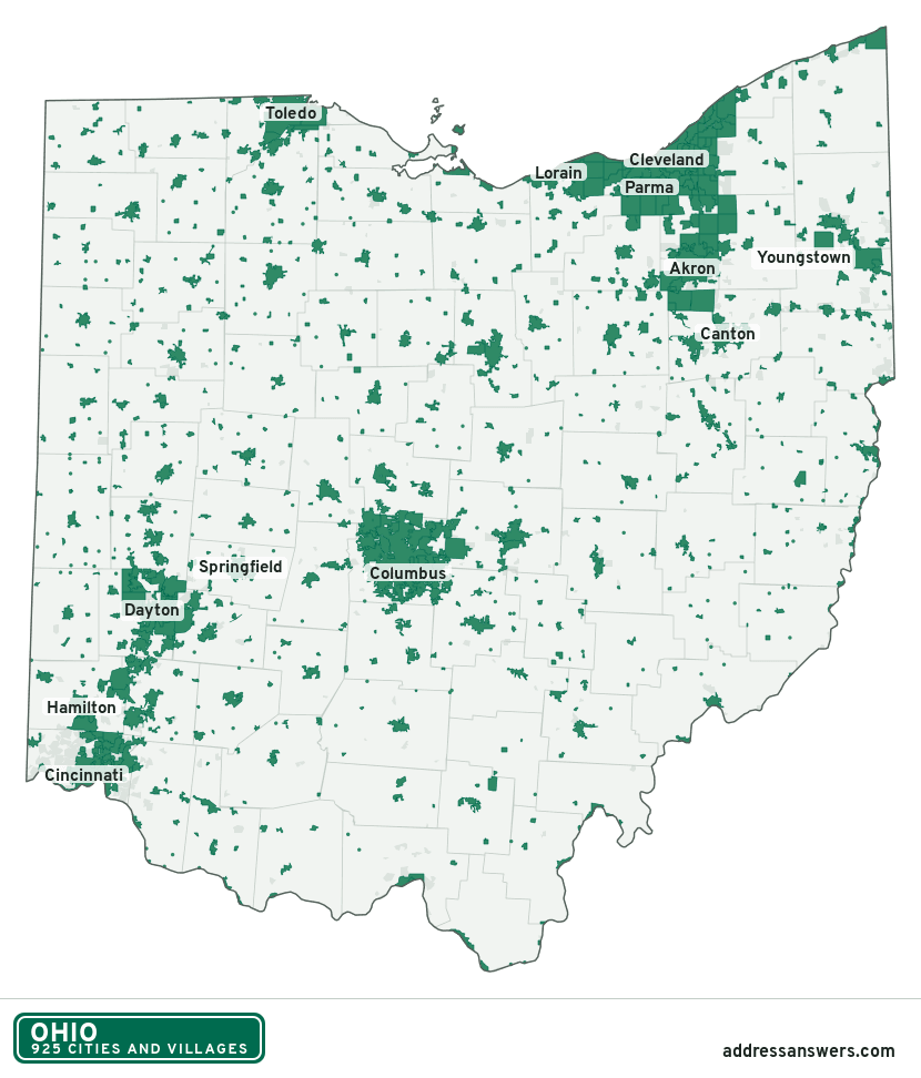
Ohio city limits map image
The map above as a picture: every Ohio city and town in green, with county lines. Boundaries from the Census Bureau, as of January 1, 2025.
You’re welcome to use it in a document or on your own site, with a link back to this page.
Download the map (PNG, 830 × 972)Questions about Ohio city limits
How many cities and villages are in Ohio?
Ohio has 925 incorporated places: 253 cities and 672 villages, by the Census Bureau’s boundary files for 2025.
What is the largest city in Ohio?
By population, Columbus, with about 914,802 residents (2020–2024 American Community Survey 5-year estimates). It is also the largest by land area, at 221.9 square miles.
What is the smallest village in Ohio?
By the Census Bureau’s estimate, Chilo, with 15 residents. Estimates for places this small have a wide margin of error, so treat it as a rough count.
How much of Ohio is unincorporated?
90% of its land and 4.1 million of its residents (35%) are outside every city or village. There, local government is the township and the county. The state also has 340 named unincorporated communities; the largest is Austintown.
Is Austintown, OH a city?
No. Austintown is a census-designated place: a community the Census Bureau maps for statistics, with no city government of its own. About 30,164 people live there, in Mahoning County, in a township rather than a city. An address there is outside city limits, even if its mailing address says otherwise.
Is White Oak, OH a city?
No. White Oak is a census-designated place: a community the Census Bureau maps for statistics, with no city government of its own. About 19,216 people live there, in Hamilton County, in a township rather than a city. An address there is outside city limits, even if its mailing address says otherwise.
Which cities and villages in Ohio are in more than one county?
67 of the 925 cross a county line, by at least 1% of their land. The largest: Columbus (Franklin and Delaware), Youngstown (Mahoning and Trumbull), and Kettering (Montgomery and Greene). Check an address to see which county it’s in.
Which county in Ohio has the most cities and villages?
Cuyahoga County, with 57 at least partly inside it. Every county in Ohio has at least one.
Bordering states
More answers for a Ohio address
Each tool checks the same address and puts its own answer first.
- County Census Your county, plus the township or town where those exist. Find your county
- School district Census The public school district that covers the address. Find your school district
- Flood zone FEMA The FEMA zone in plain English, and whether lenders require flood insurance. Check flood zone
- USDA home loans USDA Whether the property is in an area eligible for a USDA Rural Development loan. Check USDA eligibility
- Voting districts Census Your congressional district and your state senate and state house districts. Included in every check
Places, boundaries, land area and counties: US Census Bureau 2025 cartographic boundary files (boundaries as of January 1, 2025). A place is listed in each county that holds at least 1% of its land. Population: 2020–2024 American Community Survey 5-year estimates. Data updated October 24, 2026; page updated October 25, 2026. Boundaries change through annexation; your city or county has the official map.