Missouri city limits map
Missouri has 947 incorporated places: 644 cities, 196 villages, and 107 towns. They cover 4.4% of the state’s land and are home to 67% of its residents. Everyone else lives outside city limits, where local government is the county. Enter an address to see which side of a city line it’s on.
Result for
The map couldn’t load. The answers don’t depend on it.
The boundary couldn’t load. The answer doesn’t depend on it.
Census Geocoder match
More about this address
Sources and limits
- Census
- US Census Bureau Geocoder, current boundaries
- FEMA
- National Flood Hazard Layer, effective flood maps
- USDA
- Rural Development property eligibility
- Map
- Boundaries from Census TIGERweb, flood zones drawn by FEMA, eligible areas from USDA, base map © OpenStreetMap contributors
Census boundaries are updated once a year, so a recent annexation may not show yet. Informational only, not an official determination. Verify with your city or county.
Missouri at a glance
- Incorporated places
- 947
- 644 cities, 196 villages, and 107 towns
- Residents in city limits
- 67%
- 4,156,109 of 6,191,814
- Land in city limits
- 4.4%
- 3,020 of 68,746 sq mi
- Counties
- 115
- Every one has at least one
- Unincorporated communities
- 134
- Largest: Oakville (35,333)
- Largest city
- Kansas City
- 510,612 residents
How local government works in Missouri
St. Louis is an independent city, separate from St. Louis County around it.
The Census Bureau maps 1,393 townships in Missouri. In some counties they have elected officers; in others they exist only on maps. A township isn’t a city, so an address in one is outside city limits unless it’s also inside a city.
City limits maps for 6 Missouri cities
Every Missouri city with 100,000 or more residents has its own page: the boundary in detail, the places around it and its school districts.
All 947 municipalities in Missouri
Every incorporated place, largest first, with the counties it’s in and its size. An address inside one of these is inside city limits; anywhere else in the state is unincorporated.
| Name | Type | County | Population | Land (sq mi) |
|---|---|---|---|---|
| Kansas City | City | Jackson, Clay +1 | 510,612 | 314.5 |
| St. Louis | City | Independent city | 288,512 | 61.7 |
| Springfield | City | Greene | 169,954 | 83.3 |
| Columbia | City | Boone | 128,548 | 67.8 |
| Independence | City | Jackson | 121,740 | 78.0 |
| Lee's Summit | City | Jackson, Cass | 103,656 | 63.9 |
| O'Fallon | City | St. Charles | 93,801 | 31.0 |
| St. Charles | City | St. Charles | 71,508 | 25.2 |
| St. Joseph | City | Buchanan | 71,236 | 44.0 |
| Blue Springs | City | Jackson | 59,965 | 22.2 |
| St. Peters | City | St. Charles | 59,092 | 22.5 |
| Joplin | City | Jasper, Newton | 52,593 | 38.1 |
| Florissant | City | St. Louis | 51,773 | 12.6 |
| Chesterfield | City | St. Louis | 49,574 | 31.8 |
| Wentzville | City | St. Charles | 47,061 | 22.0 |
| Jefferson City | City | Cole, Callaway | 42,488 | 36.1 |
| Cape Girardeau | City | Cape Girardeau, Scott | 40,344 | 29.3 |
| Wildwood | City | St. Louis | 35,133 | 67.0 |
| University City | City | St. Louis | 34,685 | 5.88 |
| Ballwin | City | St. Louis | 31,279 | 9.08 |
| Liberty | City | Clay | 30,689 | 29.7 |
| Raytown | City | Jackson | 29,445 | 9.93 |
| Kirkwood | City | St. Louis | 29,363 | 9.18 |
| Maryland Heights | City | St. Louis | 27,880 | 21.9 |
| Gladstone | City | Clay | 27,207 | 8.08 |
| Grandview | City | Jackson | 26,527 | 14.7 |
| Hazelwood | City | St. Louis | 25,114 | 16.0 |
| Belton | City | Cass | 25,008 | 14.4 |
| Nixa | City | Christian | 24,836 | 9.41 |
| Raymore | City | Cass | 24,526 | 17.3 |
| Webster Groves | City | St. Louis | 23,712 | 5.91 |
| Ozark | City | Christian | 22,417 | 12.1 |
| Sedalia | City | Pettis | 22,003 | 15.0 |
| Arnold | City | Jefferson | 20,956 | 11.5 |
| Rolla | City | Phelps | 20,287 | 12.1 |
| Republic | City | Greene, Christian | 19,829 | 16.0 |
| Warrensburg | City | Johnson | 19,582 | 9.41 |
| Creve Coeur | City | St. Louis | 18,643 | 10.3 |
| Farmington | City | St. Francois | 18,282 | 9.49 |
| Ferguson | City | St. Louis | 18,213 | 6.17 |
| Manchester | City | St. Louis | 18,160 | 5.04 |
| Lake St. Louis | City | St. Charles | 18,066 | 8.57 |
| Kirksville | City | Adair | 17,563 | 14.4 |
| Clayton | City | St. Louis | 17,380 | 2.51 |
| Hannibal | City | Marion, Ralls | 16,771 | 16.0 |
| Sikeston | City | Scott, New Madrid | 16,320 | 17.9 |
| Grain Valley | City | Jackson | 16,271 | 6.16 |
| Poplar Bluff | City | Butler | 16,254 | 13.5 |
| Overland | City | St. Louis | 15,695 | 4.39 |
| Jackson | City | Cape Girardeau | 15,659 | 10.8 |
| Carthage | City | Jasper | 15,574 | 12.1 |
| Lebanon | City | Laclede | 15,270 | 14.6 |
| Washington | City | Franklin | 15,130 | 10.1 |
| Troy | City | Lincoln | 13,947 | 7.72 |
| Marshall | City | Saline | 13,739 | 10.1 |
| Moberly | City | Randolph | 13,526 | 13.2 |
| Dardenne Prairie | City | St. Charles | 13,503 | 5.34 |
| Neosho | City | Newton | 13,224 | 15.6 |
| Webb City | City | Jasper | 13,221 | 8.68 |
| Festus | City | Jefferson | 13,201 | 5.93 |
| Eureka | City | St. Louis, Jefferson | 13,081 | 11.2 |
| Jennings | City | St. Louis | 12,918 | 3.73 |
| Branson | City | Taney | 12,817 | 21.3 |
| St. Ann | City | St. Louis | 12,811 | 3.16 |
| Union | City | Franklin | 12,781 | 9.09 |
| Fulton | City | Callaway | 12,617 | 12.3 |
| West Plains | City | Howell | 12,441 | 13.3 |
| Crestwood | City | St. Louis | 12,295 | 3.59 |
| Town and Country | City | St. Louis | 11,607 | 11.5 |
| Mexico | City | Audrain | 11,477 | 12.2 |
| Bridgeton | City | St. Louis | 11,369 | 14.6 |
| Bolivar | City | Polk | 11,170 | 8.23 |
| Kearney | City | Clay | 10,885 | 13.3 |
| Smithville | City | Clay | 10,705 | 16.5 |
| Bellefontaine Neighbors | City | St. Louis | 10,498 | 4.40 |
| Excelsior Springs | City | Clay, Ray | 10,484 | 10.8 |
| Maryville | City | Nodaway | 10,428 | 6.50 |
| Kennett | City | Dunklin | 10,196 | 7.00 |
| Ellisville | City | St. Louis | 10,002 | 4.37 |
| Harrisonville | City | Cass | 9,970 | 11.2 |
| Monett | City | Barry, Lawrence | 9,873 | 8.79 |
| Des Peres | City | St. Louis | 9,170 | 4.32 |
| Richmond Heights | City | St. Louis | 9,153 | 2.29 |
| Sunset Hills | City | St. Louis | 9,112 | 8.98 |
| Warrenton | City | Warren | 9,066 | 9.05 |
| Clinton | City | Henry | 9,065 | 9.12 |
| Ladue | City | St. Louis | 8,940 | 8.56 |
| Chillicothe | City | Livingston | 8,923 | 7.64 |
| Pleasant Hill | City | Cass, Jackson | 8,847 | 8.05 |
| Park Hills | City | St. Francois | 8,678 | 20.3 |
| Olivette | City | St. Louis | 8,645 | 2.77 |
| Oak Grove | City | Jackson, Lafayette | 8,538 | 6.41 |
| Perryville | City | Perry | 8,536 | 8.16 |
| Cameron | City | Clinton, DeKalb +1 | 8,519 | 6.94 |
| Parkville | City | Platte | 8,366 | 15.0 |
| Carl Junction | City | Jasper | 8,339 | 5.53 |
| Maplewood | City | St. Louis | 8,156 | 1.57 |
| Brentwood | City | St. Louis | 8,144 | 1.95 |
| Berkeley | City | St. Louis | 8,123 | 4.96 |
| Nevada | City | Vernon | 7,925 | 9.08 |
| Dexter | City | Stoddard | 7,891 | 7.21 |
| Marshfield | City | Webster | 7,696 | 5.52 |
| Boonville | City | Cooper | 7,689 | 8.28 |
| Pacific | City | Franklin, St. Louis | 7,475 | 6.88 |
| Aurora | City | Lawrence | 7,397 | 6.40 |
| Valley Park | City | St. Louis | 6,795 | 4.51 |
| Bonne Terre | City | St. Francois | 6,683 | 4.07 |
| Black Jack | City | St. Louis | 6,589 | 2.59 |
| St. John | City | St. Louis | 6,527 | 1.42 |
| Willard | City | Greene | 6,488 | 6.04 |
| De Soto | City | Jefferson | 6,470 | 4.50 |
| Shrewsbury | City | St. Louis | 6,316 | 1.44 |
| Sullivan | City | Franklin, Crawford | 6,310 | 8.15 |
| Battlefield | City | Greene | 6,165 | 2.59 |
| Glendale | City | St. Louis | 6,114 | 1.30 |
| Pevely | City | Jefferson | 6,055 | 5.07 |
| Greenwood | City | Jackson, Cass | 6,013 | 5.22 |
| Richmond | City | Ray | 5,959 | 6.15 |
| Peculiar | City | Cass | 5,958 | 9.06 |
| Cottleville | City | St. Charles | 5,937 | 4.74 |
| Odessa | City | Lafayette | 5,620 | 4.10 |
| Trenton | City | Grundy | 5,536 | 6.45 |
| Macon | City | Macon | 5,466 | 6.06 |
| Waynesville | City | Pulaski | 5,442 | 7.15 |
| St. Robert | City | Pulaski | 5,356 | 8.42 |
| Caruthersville | City | Pemiscot | 5,326 | 5.16 |
| Weldon Spring | City | St. Charles | 5,310 | 7.65 |
| Wright City | City | Warren | 5,240 | 6.06 |
| Herculaneum | City | Jefferson | 5,071 | 4.17 |
| Savannah | City | Andrew | 5,053 | 3.25 |
| Ste. Genevieve | City | Ste. Genevieve | 5,010 | 3.90 |
| North Kansas City | City | Clay | 4,983 | 4.37 |
| Ashland | City | Boone | 4,914 | 6.24 |
| Rogersville | City | Greene, Webster | 4,908 | 3.80 |
| Osage Beach | City | Camden, Miller | 4,905 | 9.84 |
| Desloge | City | St. Francois | 4,863 | 2.92 |
| Dellwood | City | St. Louis | 4,847 | 1.04 |
| Platte City | City | Platte | 4,824 | 3.96 |
| St. Clair | City | Franklin | 4,789 | 4.82 |
| Higginsville | City | Lafayette | 4,781 | 3.77 |
| Crystal City | City | Jefferson | 4,718 | 4.65 |
| Rock Hill | City | St. Louis | 4,693 | 1.10 |
| Centralia | City | Boone | 4,690 | 2.91 |
| Salem | City | Dent | 4,677 | 3.48 |
| Butler | City | Bates | 4,668 | 4.07 |
| Hollister | City | Taney | 4,643 | 6.37 |
| Holts Summit | City | Callaway | 4,609 | 3.71 |
| Lexington | City | Lafayette | 4,606 | 5.23 |
| Mount Vernon | City | Lawrence | 4,563 | 4.14 |
| Eldon | City | Miller | 4,556 | 3.52 |
| California | City | Moniteau | 4,509 | 3.87 |
| Fredericktown | City | Madison | 4,507 | 4.33 |
| Mountain Grove | City | Wright, Texas | 4,491 | 4.01 |
| Charleston | City | Mississippi | 4,482 | 4.80 |
| Breckenridge Hills | City | St. Louis | 4,402 | 0.80 |
| Scott City | City | Scott, Cape Girardeau | 4,371 | 4.88 |
| Lamar | City | Barton | 4,284 | 5.21 |
| Riverside | City | Platte | 4,276 | 5.53 |
| Normandy | City | St. Louis | 4,239 | 1.89 |
| Bowling Green | City | Pike | 4,170 | 2.69 |
| Brookfield | City | Linn | 4,144 | 4.35 |
| Fenton | City | St. Louis | 4,088 | 6.27 |
| Camdenton | City | Camden | 4,023 | 5.70 |
| St. James | City | Phelps | 3,916 | 4.24 |
| Woodson Terrace | City | St. Louis | 3,908 | 0.77 |
| Moscow Mills | City | Lincoln | 3,823 | 3.16 |
| Malden | City | Dunklin | 3,805 | 8.32 |
| Frontenac | City | St. Louis | 3,701 | 2.88 |
| Northwoods | City | St. Louis | 3,623 | 0.70 |
| Palmyra | City | Marion | 3,623 | 3.08 |
| El Dorado Springs | City | Cedar | 3,586 | 3.08 |
| Hillsboro | City | Jefferson | 3,500 | 3.84 |
| St. Paul | City | St. Charles | 3,456 | 7.21 |
| Buffalo | City | Dallas | 3,417 | 3.00 |
| New Haven | City | Franklin | 3,302 | 3.18 |
| Sugar Creek | City | Jackson, Clay | 3,249 | 11.0 |
| Louisiana | City | Pike | 3,228 | 3.13 |
| Cassville | City | Barry | 3,202 | 3.42 |
| Byrnes Mill | City | Jefferson | 3,189 | 5.15 |
| Cuba | City | Crawford | 3,189 | 3.19 |
| Carrollton | City | Carroll | 3,145 | 4.17 |
| Vandalia | City | Audrain | 3,140 | 2.25 |
| Windsor | City | Henry, Pettis | 3,094 | 2.42 |
| Bethany | City | Harrison | 3,080 | 4.44 |
| Ava | City | Douglas | 3,045 | 3.32 |
| Clever | City | Christian | 3,030 | 1.63 |
| Monroe City | City | Monroe, Marion +1 | 3,028 | 3.03 |
| Chaffee | City | Scott | 3,026 | 1.79 |
| Country Club | Village | Andrew | 2,935 | 3.91 |
| Buckner | City | Jackson | 2,914 | 1.79 |
| Piedmont | City | Wayne | 2,911 | 2.15 |
| Lawson | City | Clay, Ray | 2,905 | 2.96 |
| East Prairie | City | Mississippi | 2,902 | 1.25 |
| Licking | City | Texas | 2,858 | 2.13 |
| Moline Acres | City | St. Louis | 2,843 | 0.57 |
| Knob Noster | City | Johnson | 2,838 | 2.88 |
| Portageville | City | New Madrid, Pemiscot | 2,825 | 2.04 |
| Owensville | City | Gasconade | 2,806 | 2.60 |
| Oronogo | City | Jasper | 2,804 | 2.49 |
| Fayette | City | Howard | 2,801 | 2.22 |
| Montgomery City | City | Montgomery | 2,801 | 3.42 |
| Marionville | City | Lawrence | 2,785 | 1.79 |
| Forsyth | City | Taney | 2,766 | 3.38 |
| Canton | City | Lewis | 2,752 | 2.33 |
| Granby | City | Newton | 2,745 | 4.43 |
| Pleasant Valley | City | Clay | 2,736 | 1.26 |
| Riverview | Village | St. Louis | 2,731 | 0.83 |
| Pine Lawn | City | St. Louis | 2,716 | 0.62 |
| Green Park | City | St. Louis | 2,690 | 1.31 |
| Anderson | City | McDonald | 2,685 | 2.27 |
| Strafford | City | Greene, Webster | 2,672 | 3.40 |
| Tipton | City | Moniteau | 2,667 | 2.09 |
| New Madrid | City | New Madrid | 2,662 | 4.50 |
| Mountain View | City | Howell | 2,658 | 3.78 |
| Versailles | City | Morgan | 2,610 | 2.40 |
| Clarkson Valley | City | St. Louis | 2,584 | 2.69 |
| Lathrop | City | Clinton | 2,560 | 4.19 |
| Potosi | City | Washington | 2,544 | 2.33 |
| Pagedale | City | St. Louis | 2,531 | 1.21 |
| Kimberling City | City | Stone | 2,476 | 3.50 |
| Lake Lotawana | City | Jackson | 2,442 | 10.3 |
| Bel-Ridge | Village | St. Louis | 2,432 | 0.77 |
| Weatherby Lake | City | Platte | 2,401 | 1.03 |
| Warson Woods | City | St. Louis | 2,393 | 0.57 |
| Cabool | City | Texas | 2,348 | 4.02 |
| Doniphan | City | Ripley | 2,345 | 1.38 |
| Lake Ozark | City | Miller, Camden | 2,335 | 7.21 |
| Thayer | City | Oregon | 2,333 | 2.44 |
| Concordia | City | Lafayette | 2,332 | 1.84 |
| Sparta | City | Christian | 2,331 | 1.24 |
| Marthasville | City | Warren | 2,328 | 0.85 |
| Marceline | City | Linn, Chariton | 2,292 | 3.28 |
| Hermann | City | Gasconade | 2,290 | 2.55 |
| Willow Springs | City | Howell | 2,279 | 3.61 |
| Duquesne | Village | Jasper | 2,257 | 1.95 |
| Plattsburg | City | Clinton | 2,253 | 3.60 |
| Village of Four Seasons | Village | Camden | 2,252 | 4.65 |
| Houston | City | Texas | 2,226 | 3.64 |
| Seymour | City | Webster | 2,179 | 3.48 |
| Hanley Hills | Village | St. Louis | 2,178 | 0.35 |
| Marlborough | Village | St. Louis | 2,157 | 0.23 |
| Richland | City | Pulaski, Camden +1 | 2,136 | 2.28 |
| Hayti | City | Pemiscot | 2,090 | 2.30 |
| Carterville | City | Jasper | 2,074 | 2.61 |
| Kahoka | City | Clark | 2,072 | 1.59 |
| Bloomfield | City | Stoddard | 2,069 | 1.25 |
| Slater | City | Saline | 2,066 | 1.45 |
| Merriam Woods | City | Taney | 2,047 | 1.51 |
| Vinita Park | City | St. Louis | 2,042 | 0.78 |
| Holden | City | Johnson | 1,989 | 2.41 |
| Warsaw | City | Benton | 1,980 | 2.49 |
| Stockton | City | Cedar | 1,950 | 2.12 |
| Winchester | City | St. Louis | 1,939 | 0.24 |
| Hallsville | City | Boone | 1,927 | 1.60 |
| Weston | City | Platte | 1,922 | 3.76 |
| Duenweg | City | Jasper | 1,918 | 3.32 |
| Noel | City | McDonald | 1,913 | 2.03 |
| Albany | City | Gentry | 1,909 | 2.44 |
| Seneca | City | Newton | 1,906 | 2.56 |
| Elsberry | City | Lincoln | 1,870 | 1.51 |
| Milan | City | Sullivan | 1,859 | 1.77 |
| Adrian | City | Bates | 1,857 | 1.67 |
| Unionville | City | Putnam | 1,824 | 2.00 |
| Claycomo | Village | Clay | 1,820 | 2.60 |
| Gower | City | Clinton, Buchanan | 1,799 | 1.04 |
| Lincoln | City | Benton | 1,787 | 0.95 |
| Memphis | City | Scotland | 1,782 | 1.56 |
| Lake Winnebago | City | Cass | 1,773 | 2.32 |
| Campbell | City | Dunklin | 1,766 | 1.40 |
| Crane | City | Stone | 1,760 | 1.69 |
| Marble Hill | City | Bollinger | 1,758 | 1.65 |
| Hamilton | City | Caldwell | 1,755 | 1.47 |
| Winfield | City | Lincoln | 1,745 | 1.05 |
| Garden City | City | Cass | 1,742 | 2.47 |
| Gallatin | City | Daviess | 1,740 | 2.75 |
| Bernie | City | Stoddard | 1,725 | 1.31 |
| Fair Grove | City | Greene | 1,717 | 3.19 |
| Ironton | City | Iron | 1,692 | 1.34 |
| Huntsville | City | Randolph | 1,672 | 2.32 |
| Steelville | City | Crawford | 1,665 | 2.42 |
| Senath | City | Dunklin | 1,662 | 1.92 |
| Shelbina | City | Shelby | 1,653 | 2.34 |
| Bourbon | City | Crawford | 1,636 | 1.34 |
| Wellston | City | St. Louis | 1,628 | 0.93 |
| Charlack | City | St. Louis | 1,596 | 0.27 |
| Paris | City | Monroe | 1,587 | 1.26 |
| Wardsville | Village | Cole | 1,579 | 3.46 |
| Fremont Hills | City | Christian | 1,574 | 0.56 |
| Sarcoxie | City | Jasper | 1,574 | 1.46 |
| Oakland | City | St. Louis | 1,562 | 0.60 |
| Bel-Nor | Village | St. Louis | 1,556 | 0.63 |
| Calverton Park | City | St. Louis | 1,546 | 0.41 |
| Salisbury | City | Chariton | 1,540 | 1.34 |
| Mansfield | City | Wright | 1,524 | 1.87 |
| Bismarck | City | St. Francois | 1,508 | 1.00 |
| Steele | City | Pemiscot | 1,493 | 2.16 |
| Pierce City | City | Lawrence | 1,477 | 1.29 |
| Tarkio | City | Atchison | 1,471 | 1.39 |
| Rich Hill | City | Bates | 1,453 | 1.37 |
| Auxvasse | City | Callaway | 1,452 | 0.76 |
| Advance | City | Stoddard | 1,450 | 1.12 |
| Cole Camp | City | Benton | 1,436 | 1.30 |
| Lone Jack | City | Jackson | 1,412 | 5.92 |
| Cool Valley | City | St. Louis | 1,411 | 0.46 |
| Lakeshire | City | St. Louis | 1,396 | 0.22 |
| Gerald | City | Franklin | 1,368 | 1.46 |
| Leadwood | City | St. Francois | 1,354 | 1.16 |
| Princeton | City | Mercer | 1,352 | 1.59 |
| La Plata | City | Macon | 1,351 | 1.59 |
| Dixon | City | Pulaski | 1,334 | 1.04 |
| Ash Grove | City | Greene | 1,333 | 1.33 |
| Archie | City | Cass | 1,322 | 1.50 |
| Sweet Springs | City | Saline | 1,268 | 1.66 |
| Edina | City | Knox | 1,250 | 1.31 |
| Belle | City | Maries, Osage | 1,246 | 1.33 |
| Taos | City | Cole | 1,242 | 6.43 |
| Loma Linda | Town | Newton | 1,239 | 3.56 |
| Stanberry | City | Gentry | 1,235 | 1.40 |
| Greenfield | City | Dade | 1,229 | 1.14 |
| St. Martins | City | Cole | 1,228 | 1.94 |
| Appleton City | City | St. Clair | 1,221 | 1.15 |
| Rock Port | City | Atchison | 1,221 | 2.77 |
| Linn | City | Osage | 1,197 | 1.17 |
| Flordell Hills | City | St. Louis | 1,195 | 0.12 |
| Pasadena Hills | City | St. Louis | 1,190 | 0.21 |
| Lake Waukomis | City | Platte | 1,170 | 0.29 |
| New Franklin | City | Howard | 1,170 | 1.32 |
| Wellsville | City | Montgomery | 1,165 | 1.54 |
| Van Buren | Town | Carter | 1,161 | 2.00 |
| Velda City | City | St. Louis | 1,158 | 0.16 |
| New London | City | Ralls | 1,130 | 0.69 |
| La Monte | City | Pettis | 1,126 | 1.08 |
| Purdy | City | Barry | 1,121 | 0.65 |
| Glasgow | City | Howard, Chariton | 1,118 | 1.35 |
| Reeds Spring | City | Stone | 1,112 | 1.50 |
| Foristell | City | Warren, St. Charles | 1,096 | 6.08 |
| Goodman | City | McDonald | 1,092 | 1.33 |
| Mound City | City | Holt | 1,066 | 1.25 |
| Grantwood Village | Town | St. Louis | 1,058 | 0.82 |
| Humansville | City | Polk | 1,058 | 1.25 |
| Ellington | City | Reynolds | 1,057 | 1.46 |
| Osceola | City | St. Clair | 1,042 | 1.08 |
| Sturgeon | City | Boone | 1,035 | 0.90 |
| La Grange | City | Lewis | 1,033 | 1.56 |
| Oran | City | Scott | 1,033 | 1.05 |
| Crocker | City | Pulaski | 1,024 | 1.23 |
| Gainesville | City | Ozark | 1,010 | 2.87 |
| Southwest City | Town | McDonald | 992 | 1.46 |
| Truesdale | City | Warren | 990 | 1.28 |
| Stover | City | Morgan | 977 | 0.89 |
| Edmundson | City | St. Louis | 975 | 0.27 |
| Cleveland | City | Cass | 968 | 1.49 |
| Laurie | City | Morgan, Camden | 965 | 5.50 |
| Grant City | Town | Worth | 959 | 1.33 |
| Clarkton | City | Dunklin | 958 | 1.13 |
| Highlandville | City | Christian | 950 | 4.92 |
| Loch Lloyd | Village | Cass | 950 | 1.74 |
| Miner | City | Scott, Mississippi | 950 | 4.61 |
| Maysville | City | DeKalb | 947 | 1.15 |
| Airport Drive | Village | Jasper | 941 | 2.00 |
| Seligman | City | Barry | 941 | 1.24 |
| Drexel | City | Cass, Bates | 924 | 2.73 |
| Diamond | Town | Newton | 914 | 0.78 |
| Lilbourn | City | New Madrid | 905 | 0.95 |
| Leadington | City | St. Francois | 901 | 0.91 |
| Waverly | City | Lafayette | 901 | 1.26 |
| Oregon | City | Holt | 882 | 0.93 |
| New Bloomfield | City | Callaway | 876 | 1.58 |
| Hillsdale | Village | St. Louis | 873 | 0.34 |
| Agency | Village | Buchanan | 871 | 3.68 |
| Clarence | City | Shelby | 862 | 1.16 |
| Brunswick | City | Chariton | 859 | 1.20 |
| Velda Village Hills | City | St. Louis | 858 | 0.12 |
| Country Club Hills | City | St. Louis | 854 | 0.19 |
| Winona | City | Shannon | 854 | 3.81 |
| Puxico | City | Stoddard | 846 | 0.67 |
| Billings | City | Christian | 844 | 0.98 |
| Stewartsville | City | DeKalb | 844 | 0.99 |
| Innsbrook | Village | Warren | 843 | 10.0 |
| Bloomsdale | City | Ste. Genevieve | 841 | 1.63 |
| Russellville | City | Cole | 833 | 0.87 |
| King City | City | Gentry | 830 | 1.38 |
| Benton | City | Scott | 826 | 0.64 |
| Lockwood | City | Dade | 821 | 0.97 |
| Exeter | City | Barry | 819 | 0.74 |
| Cardwell | City | Dunklin | 816 | 0.63 |
| Jasper | City | Jasper | 808 | 1.11 |
| Jonesburg | City | Montgomery | 806 | 2.01 |
| Viburnum | City | Iron | 803 | 1.72 |
| Norwood Court | Town | St. Louis | 797 | 0.12 |
| Braymer | City | Caldwell | 795 | 0.59 |
| Greendale | City | St. Louis | 794 | 0.19 |
| Wood Heights | City | Ray | 784 | 2.28 |
| Iron Mountain Lake | City | St. Francois | 781 | 1.96 |
| La Belle | City | Lewis | 775 | 0.68 |
| Miller | City | Lawrence | 769 | 0.77 |
| Rockaway Beach | City | Taney | 760 | 0.63 |
| Ferrelview | Village | Platte | 752 | 0.11 |
| Liberal | City | Barton | 747 | 0.84 |
| Alton | City | Oregon | 744 | 1.57 |
| Pilot Grove | City | Cooper | 744 | 0.42 |
| Lancaster | City | Schuyler | 742 | 1.49 |
| Hawk Point | City | Lincoln | 736 | 0.42 |
| Pineville | City | McDonald | 736 | 3.29 |
| Hermitage | City | Hickory | 734 | 1.30 |
| Twin Oaks | Village | St. Louis | 734 | 0.27 |
| Bertrand | City | Mississippi | 732 | 0.82 |
| Conway | City | Laclede | 732 | 1.82 |
| Orrick | City | Ray | 727 | 1.43 |
| Pleasant Hope | City | Polk | 716 | 1.52 |
| Morehouse | City | New Madrid | 715 | 0.80 |
| Pasadena Park | Village | St. Louis | 710 | 0.10 |
| Jamesport | City | Daviess | 709 | 0.56 |
| Golden City | City | Barton | 708 | 1.03 |
| Lake Tapawingo | City | Jackson | 706 | 0.32 |
| Fairfax | City | Atchison | 702 | 0.47 |
| Olympian Village | City | Jefferson | 694 | 0.57 |
| Bella Villa | City | St. Louis | 691 | 0.13 |
| Freeman | City | Cass | 690 | 0.86 |
| Hardin | City | Ray | 681 | 0.64 |
| Norwood | City | Wright | 681 | 1.60 |
| Ellsinore | City | Carter | 678 | 0.51 |
| Norborne | City | Carroll | 676 | 0.65 |
| Sycamore Hills | Village | St. Louis | 672 | 0.13 |
| New Florence | City | Montgomery | 667 | 3.01 |
| Holcomb | City | Dunklin | 666 | 0.58 |
| Josephville | Village | St. Charles | 664 | 2.86 |
| Gideon | City | New Madrid | 662 | 1.79 |
| Iberia | City | Miller | 661 | 0.88 |
| Vienna | City | Maries | 661 | 1.07 |
| Leeton | City | Johnson | 660 | 0.52 |
| Green City | City | Sullivan | 658 | 1.43 |
| Bevier | City | Macon | 657 | 1.04 |
| Pilot Knob | City | Iron | 653 | 0.89 |
| Queen City | City | Schuyler | 650 | 1.03 |
| Perry | City | Ralls | 640 | 1.38 |
| Alba | City | Jasper | 624 | 0.33 |
| Parkway | Village | Franklin | 624 | 0.46 |
| Irondale | City | Washington | 622 | 0.53 |
| Shelbyville | City | Shelby | 621 | 0.78 |
| Lowry City | City | St. Clair | 618 | 1.03 |
| Hartville | City | Wright | 610 | 0.65 |
| Kelso | Village | Scott | 603 | 0.31 |
| Parma | City | New Madrid | 596 | 0.64 |
| Fair Play | City | Polk | 595 | 0.43 |
| Morrisville | Town | Polk | 595 | 0.66 |
| Fordland | City | Webster | 594 | 1.12 |
| Glenaire | City | Clay | 587 | 0.27 |
| St. Elizabeth | Village | Miller | 587 | 1.15 |
| Arcadia | City | Iron | 586 | 0.83 |
| Flint Hill | City | St. Charles | 583 | 2.85 |
| Qulin | City | Butler | 570 | 0.45 |
| Ravenwood | Town | Nodaway | 563 | 0.31 |
| Raymondville | Town | Texas | 563 | 2.95 |
| Doolittle | City | Phelps | 561 | 2.78 |
| Matthews | City | New Madrid | 561 | 1.96 |
| Trimble | City | Clinton | 561 | 0.64 |
| Union Star | Town | DeKalb | 559 | 0.26 |
| Dearborn | City | Platte, Buchanan | 557 | 0.82 |
| Crystal Lake Park | City | St. Louis | 553 | 0.10 |
| Galena | City | Stone | 550 | 0.74 |
| Ewing | City | Lewis | 542 | 0.62 |
| Hayti Heights | City | Pemiscot | 540 | 0.98 |
| Morley | City | Scott | 540 | 0.80 |
| Center | City | Ralls | 537 | 0.41 |
| Niangua | City | Webster | 537 | 0.41 |
| Branson West | City | Stone | 536 | 4.72 |
| Smithton | City | Pettis | 535 | 0.30 |
| Laddonia | City | Audrain | 533 | 0.70 |
| Delta | City | Cape Girardeau | 532 | 0.39 |
| Platte Woods | City | Platte | 532 | 0.39 |
| Hornersville | City | Dunklin | 531 | 0.78 |
| Walnut Grove | City | Greene | 528 | 0.62 |
| Hale | City | Carroll | 525 | 0.55 |
| Martinsburg | Town | Audrain | 522 | 0.27 |
| Weaubleau | City | Hickory | 521 | 0.86 |
| De Kalb | Town | Buchanan | 518 | 0.26 |
| Edgerton | City | Platte | 518 | 1.13 |
| Leawood | Village | Newton | 512 | 1.23 |
| Higbee | City | Randolph | 507 | 0.40 |
| Fisk | City | Butler | 502 | 0.32 |
| Frankford | City | Pike | 502 | 0.44 |
| Kidder | City | Caldwell | 501 | 0.40 |
| Atlanta | City | Macon | 499 | 0.34 |
| Washburn | City | Barry | 498 | 0.90 |
| Bell City | City | Stoddard | 496 | 0.55 |
| Green Ridge | City | Pettis | 496 | 0.43 |
| Wilbur Park | Village | St. Louis | 491 | 0.06 |
| Otterville | City | Cooper | 489 | 0.49 |
| Beverly Hills | City | St. Louis | 488 | 0.09 |
| Breckenridge | City | Caldwell | 485 | 0.55 |
| Shoal Creek Drive | Village | Newton | 485 | 0.47 |
| Lanagan | Town | McDonald | 483 | 0.94 |
| Meadville | City | Linn | 480 | 0.54 |
| Polo | City | Caldwell | 480 | 0.62 |
| Ridgeway | City | Harrison | 478 | 1.22 |
| Verona | Town | Lawrence | 477 | 0.87 |
| Bland | City | Gasconade, Osage | 476 | 0.65 |
| Gordonville | Village | Cape Girardeau | 473 | 0.78 |
| Urich | City | Henry | 469 | 0.40 |
| West Alton | City | St. Charles | 467 | 28.8 |
| Asbury | City | Jasper | 459 | 0.36 |
| New Melle | City | St. Charles | 452 | 1.79 |
| Alma | City | Lafayette | 450 | 0.28 |
| Eolia | Village | Pike | 449 | 1.22 |
| Blue Eye | Town | Stone | 446 | 1.18 |
| Madison | City | Monroe | 446 | 0.45 |
| Wardell | Town | Pemiscot | 445 | 0.28 |
| Sheldon | City | Vernon | 443 | 0.53 |
| Corder | City | Lafayette | 442 | 0.36 |
| Rosebud | City | Gasconade | 442 | 0.87 |
| Urbana | City | Dallas | 441 | 0.85 |
| Holt | City | Clay, Clinton | 440 | 0.52 |
| Wayland | City | Clark | 439 | 0.67 |
| Crystal Lakes | City | Ray | 436 | 1.10 |
| Keytesville | City | Chariton | 435 | 0.78 |
| Arbyrd | City | Dunklin | 432 | 1.00 |
| Wellington | City | Lafayette | 432 | 1.09 |
| Annapolis | City | Iron | 427 | 0.37 |
| Wheaton | City | Barry | 427 | 0.52 |
| Altenburg | City | Perry | 426 | 1.05 |
| Montrose | City | Henry | 425 | 0.57 |
| Osborn | City | DeKalb, Clinton | 424 | 0.57 |
| Novinger | City | Adair | 423 | 0.79 |
| Bull Creek | Village | Taney | 421 | 0.17 |
| Bucklin | City | Linn | 418 | 1.18 |
| Greenville | City | Wayne | 418 | 0.67 |
| Armstrong | City | Howard | 416 | 0.82 |
| Westphalia | City | Osage | 415 | 0.37 |
| Essex | City | Stoddard | 413 | 0.29 |
| Sunrise Beach | Village | Camden, Morgan | 413 | 5.81 |
| Summersville | City | Texas, Shannon | 409 | 1.11 |
| Windsor Place | Village | Cooper | 405 | 0.90 |
| Birch Tree | City | Shannon | 402 | 1.38 |
| Clarksville | City | Pike | 402 | 0.58 |
| Camden Point | City | Platte | 401 | 0.62 |
| Freeburg | Village | Osage | 401 | 0.83 |
| Marston | City | New Madrid | 400 | 1.10 |
| Clarksdale | City | DeKalb | 399 | 0.32 |
| Burlington Junction | City | Nodaway | 397 | 1.00 |
| Henrietta | City | Ray | 390 | 0.60 |
| Eminence | City | Shannon | 388 | 1.88 |
| Hopkins | City | Nodaway | 388 | 0.72 |
| Naylor | City | Ripley | 388 | 0.55 |
| Indian Point | Village | Stone | 387 | 2.80 |
| Maitland | City | Holt | 385 | 0.31 |
| Gilman City | City | Daviess, Harrison | 382 | 0.84 |
| Cross Timbers | City | Hickory | 379 | 0.45 |
| Oakview | Village | Clay | 377 | 0.17 |
| Chamois | City | Osage | 375 | 0.37 |
| Calhoun | City | Henry | 374 | 0.98 |
| Junction City | Village | Madison | 372 | 0.36 |
| Fairview | Town | Newton | 371 | 0.47 |
| Northmoor | City | Platte | 371 | 0.24 |
| Butterfield | City | Barry | 370 | 0.46 |
| Sibley | Village | Jackson | 369 | 1.04 |
| Huntleigh | City | St. Louis | 366 | 0.99 |
| Carytown | City | Jasper | 365 | 14.4 |
| Cobalt | Village | Madison | 364 | 0.15 |
| Kingsville | City | Johnson | 360 | 0.31 |
| Walker | City | Vernon | 359 | 0.31 |
| Neelyville | City | Butler | 358 | 1.15 |
| Silex | City | Lincoln | 355 | 0.29 |
| Fidelity | Town | Jasper | 353 | 0.97 |
| Eagleville | Town | Harrison | 352 | 1.01 |
| Grandin | City | Carter | 352 | 0.40 |
| Oak Grove Village | Village | Franklin | 347 | 0.63 |
| Lewistown | Town | Lewis | 343 | 0.50 |
| Blythedale | Village | Harrison | 341 | 0.31 |
| Portage Des Sioux | City | St. Charles | 340 | 0.58 |
| Westwood | Village | St. Louis | 338 | 0.63 |
| Saddlebrooke | Village | Christian, Taney | 337 | 5.32 |
| Bunker | City | Dent, Reynolds | 336 | 0.66 |
| Easton | City | Buchanan | 336 | 0.59 |
| Green Castle | City | Sullivan | 332 | 0.45 |
| Saginaw | Village | Newton | 332 | 0.82 |
| Greentop | City | Schuyler, Adair | 331 | 0.82 |
| Newburg | City | Phelps | 331 | 0.65 |
| Preston | Village | Hickory | 331 | 0.75 |
| Mercer | Town | Mercer | 325 | 0.37 |
| Gilliam | City | Saline | 324 | 0.25 |
| Mineral Point | Town | Washington | 324 | 0.24 |
| Purcell | City | Jasper | 324 | 0.43 |
| Kinloch | City | St. Louis | 322 | 0.73 |
| Uplands Park | Village | St. Louis | 322 | 0.07 |
| Deepwater | City | Henry | 320 | 0.85 |
| Harrisburg | Town | Boone | 312 | 0.80 |
| Mindenmines | City | Barton | 312 | 3.65 |
| Farley | Village | Platte | 309 | 1.16 |
| Tracy | City | Platte | 309 | 0.41 |
| Avondale | City | Clay | 308 | 0.14 |
| Gasconade | City | Gasconade | 306 | 0.20 |
| Clarksburg | City | Moniteau | 304 | 0.58 |
| Frohna | City | Perry | 303 | 0.90 |
| Creighton | City | Cass | 302 | 0.34 |
| Laclede | City | Linn | 301 | 1.25 |
| Mayview | City | Lafayette | 301 | 0.16 |
| Fillmore | City | Andrew | 299 | 0.14 |
| Oak Ridge | Town | Cape Girardeau | 298 | 0.59 |
| Centertown | Town | Cole | 297 | 0.95 |
| Jane | Town | McDonald | 292 | 2.97 |
| Bellerive Acres | City | St. Louis | 288 | 0.34 |
| Risco | City | New Madrid | 288 | 0.56 |
| Amazonia | Village | Andrew | 286 | 0.37 |
| Augusta | Town | St. Charles | 285 | 1.03 |
| Cooter | City | Pemiscot | 285 | 0.30 |
| St. Mary | City | Ste. Genevieve | 285 | 0.60 |
| Cedar Hill Lakes | Village | Jefferson | 284 | 0.22 |
| Williamsville | City | Wayne | 284 | 0.32 |
| Jamestown | Town | Moniteau | 280 | 1.00 |
| Jerico Springs | Village | Cedar | 279 | 0.68 |
| Leasburg | Village | Crawford | 279 | 0.43 |
| Downing | City | Schuyler | 277 | 0.66 |
| Stella | Town | Newton | 275 | 0.16 |
| Emerald Beach | Village | Barry | 274 | 0.72 |
| Houstonia | City | Pettis | 273 | 0.20 |
| Farber | City | Audrain | 272 | 0.29 |
| Houston Lake | City | Platte | 271 | 0.12 |
| Kingston | City | Caldwell | 271 | 0.52 |
| Emma | City | Lafayette, Saline | 270 | 0.59 |
| Diggins | Village | Webster | 269 | 0.98 |
| Callao | City | Macon | 263 | 0.52 |
| Rushville | Village | Buchanan | 260 | 0.20 |
| Mokane | City | Callaway | 257 | 0.29 |
| Bunceton | City | Cooper | 256 | 0.94 |
| Chain of Rocks | Village | Lincoln | 255 | 0.18 |
| Spickard | City | Grundy | 253 | 0.63 |
| Prairie Home | City | Cooper | 251 | 0.33 |
| Freistatt | Village | Lawrence | 249 | 0.21 |
| Centerview | City | Johnson | 248 | 0.19 |
| Middletown | Town | Montgomery | 248 | 0.32 |
| Wheatland | City | Hickory | 247 | 1.18 |
| Cairo | Village | Randolph | 245 | 0.30 |
| Centerville | City | Reynolds | 244 | 0.32 |
| Newtonia | Town | Newton | 244 | 0.33 |
| Lohman | City | Cole | 243 | 0.36 |
| Rensselaer | Village | Ralls | 243 | 1.96 |
| Stoutland | City | Camden, Laclede | 243 | 0.60 |
| Wyatt | City | Mississippi | 243 | 1.17 |
| Anniston | Town | Mississippi | 241 | 0.39 |
| Blackburn | City | Saline, Lafayette | 240 | 0.31 |
| Excelsior Estates | Village | Ray, Clay | 239 | 0.24 |
| Bellflower | City | Montgomery | 238 | 0.56 |
| High Hill | City | Montgomery | 238 | 0.46 |
| Lake Lafayette | City | Lafayette | 237 | 0.64 |
| Old Monroe | City | Lincoln | 236 | 0.36 |
| Dadeville | Village | Dade | 234 | 0.99 |
| Monticello | Village | Lewis | 233 | 0.26 |
| Chilhowee | Town | Johnson | 232 | 0.36 |
| Rocheport | City | Boone | 231 | 0.31 |
| St. Thomas | Town | Cole | 228 | 0.98 |
| Pattonsburg | City | Daviess | 225 | 0.61 |
| Browning | City | Linn, Sullivan | 224 | 0.52 |
| Edgar Springs | City | Phelps | 224 | 0.47 |
| Schell City | City | Vernon | 224 | 0.62 |
| Everton | City | Dade | 223 | 0.35 |
| West Sullivan | Town | Crawford | 220 | 0.36 |
| Shoal Creek Estates | Village | Newton | 218 | 0.11 |
| Conception Junction | Town | Nodaway | 217 | 0.32 |
| Elmo | City | Nodaway | 217 | 0.22 |
| Scotsdale | Town | Jefferson | 216 | 0.61 |
| Missouri City | City | Clay | 215 | 1.10 |
| New Hampton | City | Harrison | 213 | 0.55 |
| Cainsville | City | Harrison | 212 | 1.37 |
| Malta Bend | Town | Saline | 211 | 0.25 |
| Utica | Village | Livingston | 211 | 0.86 |
| Caledonia | Village | Washington | 209 | 0.16 |
| Hume | Town | Bates | 209 | 0.66 |
| Reeds | Town | Jasper | 208 | 0.15 |
| Blackwater | City | Cooper | 207 | 0.33 |
| Taneyville | Village | Taney | 206 | 0.45 |
| Glenwood | Village | Schuyler | 205 | 0.74 |
| Oakwood Park | Village | Clay | 204 | 0.07 |
| Parkdale | Village | Jefferson | 204 | 0.13 |
| Galt | City | Grundy | 203 | 0.29 |
| Bosworth | City | Carroll | 202 | 0.55 |
| Lake Tekakwitha | Village | Jefferson | 202 | 0.20 |
| Napoleon | City | Lafayette | 201 | 1.75 |
| Sedgewickville | Village | Bollinger | 201 | 0.64 |
| Clark | City | Randolph, Boone | 200 | 0.60 |
| Curryville | City | Pike | 199 | 0.27 |
| Koshkonong | Town | Oregon | 198 | 0.18 |
| Vanduser | Village | Scott | 198 | 0.13 |
| Bolckow | City | Andrew | 197 | 0.32 |
| Blodgett | City | Scott | 196 | 0.19 |
| Wyaconda | City | Clark | 195 | 0.64 |
| Mendon | City | Chariton | 194 | 0.18 |
| Forest City | City | Holt | 193 | 0.98 |
| Neck City | City | Jasper | 193 | 0.39 |
| Winston | Village | Daviess | 192 | 0.31 |
| Birmingham | Village | Clay | 189 | 0.56 |
| Parnell | City | Nodaway | 189 | 0.28 |
| Skidmore | City | Nodaway | 189 | 0.33 |
| Bakersfield | Village | Ozark | 188 | 1.37 |
| Linn Creek | City | Camden | 188 | 1.30 |
| Marquand | City | Madison | 187 | 0.24 |
| Barnard | City | Nodaway | 186 | 0.15 |
| Clearmont | City | Nodaway | 183 | 0.16 |
| Plato | Village | Texas | 183 | 0.37 |
| Brashear | City | Adair | 182 | 0.35 |
| Des Arc | Village | Iron | 181 | 0.21 |
| Luray | Village | Clark | 181 | 0.20 |
| Sheridan | Town | Worth | 181 | 0.19 |
| Haywood City | Village | Scott | 180 | 0.43 |
| Howardville | City | New Madrid | 179 | 0.23 |
| Stotts City | City | Lawrence | 178 | 0.51 |
| Theodosia | Village | Ozark | 178 | 1.37 |
| Canalou | City | New Madrid | 177 | 0.20 |
| Syracuse | City | Morgan | 177 | 0.38 |
| Tina | Village | Carroll | 177 | 0.32 |
| Cowgill | City | Caldwell | 176 | 0.24 |
| Hurdland | City | Knox | 173 | 0.33 |
| Berger | City | Franklin | 169 | 0.32 |
| Bogard | City | Carroll | 169 | 0.55 |
| Grand Falls Plaza | Town | Newton | 168 | 0.10 |
| Olean | Town | Miller | 168 | 0.20 |
| Linneus | City | Linn | 167 | 1.07 |
| Rhineland | Town | Montgomery | 165 | 0.34 |
| Phillipsburg | Village | Laclede | 164 | 0.80 |
| Bronaugh | City | Vernon | 163 | 0.29 |
| Bates City | City | Lafayette | 162 | 1.08 |
| Fountain N' Lakes | Village | Lincoln | 162 | 0.13 |
| Pickering | City | Nodaway | 162 | 0.17 |
| Chula | City | Livingston | 159 | 0.18 |
| Wheeling | City | Livingston | 157 | 0.32 |
| Oaks | Village | Clay | 156 | 0.09 |
| East Lynne | City | Cass | 155 | 0.33 |
| Miramiguoa Park | Village | Franklin | 155 | 0.39 |
| Waco | City | Jasper | 154 | 0.26 |
| Ludlow | Town | Livingston | 153 | 0.16 |
| Rockville | City | Bates | 153 | 0.33 |
| Altamont | Village | Daviess | 147 | 0.26 |
| Homestead | Village | Ray | 146 | 0.16 |
| Mill Spring | Village | Wayne | 145 | 0.44 |
| Holliday | Village | Monroe | 144 | 0.26 |
| Oakwood | Village | Clay | 142 | 0.20 |
| Tuscumbia | Town | Miller | 142 | 0.34 |
| Holland | Town | Pemiscot | 141 | 0.17 |
| Louisburg | Village | Dallas | 141 | 0.46 |
| Foley | City | Lincoln | 140 | 0.20 |
| Brandsville | City | Howell | 139 | 0.52 |
| McCord Bend | Village | Stone | 138 | 0.29 |
| South Greenfield | Village | Dade | 138 | 0.18 |
| Halfway | Village | Polk | 137 | 2.01 |
| Humphreys | Village | Sullivan | 137 | 0.25 |
| New Cambria | City | Macon | 137 | 0.67 |
| Dover | Town | Lafayette | 136 | 0.20 |
| Camden | City | Ray | 135 | 0.45 |
| Strasburg | City | Cass | 135 | 0.19 |
| Stark City | Town | Newton | 133 | 0.33 |
| Cosby | Village | Andrew | 130 | 0.09 |
| Hunnewell | City | Shelby | 130 | 0.62 |
| Rosendale | City | Andrew | 130 | 0.29 |
| Barnett | City | Morgan | 129 | 0.27 |
| Graham | Town | Nodaway | 129 | 0.27 |
| Amsterdam | City | Bates | 128 | 0.57 |
| Allenville | Village | Cape Girardeau | 127 | 0.15 |
| Vandiver | Village | Audrain | 127 | 0.31 |
| Bethel | Village | Shelby | 126 | 0.14 |
| Nelson | City | Saline | 124 | 0.33 |
| Mount Moriah | Town | Harrison | 121 | 1.02 |
| Unity Village | Village | Jackson | 121 | 1.46 |
| Weldon Spring Heights | Town | St. Charles | 121 | 0.10 |
| Amoret | City | Bates | 120 | 0.21 |
| Chain-O-Lakes | Village | Barry | 119 | 0.08 |
| Renick | Village | Randolph | 119 | 0.36 |
| Argyle | Town | Osage, Maries | 117 | 0.40 |
| Ginger Blue | Village | McDonald | 117 | 0.26 |
| Peaceful Village | Village | Jefferson | 117 | 0.20 |
| Gravois Mills | Town | Morgan | 116 | 0.74 |
| Jameson | Town | Daviess | 115 | 0.22 |
| Meta | City | Osage | 115 | 0.35 |
| Wentworth | Village | Newton | 115 | 0.18 |
| Kingdom City | Village | Callaway | 114 | 1.94 |
| Craig | City | Holt | 113 | 0.26 |
| Diehlstadt | Village | Scott | 113 | 0.07 |
| Jacksonville | Village | Randolph | 112 | 0.11 |
| Kimmswick | City | Jefferson | 112 | 0.23 |
| Rutledge | Town | Scotland | 112 | 0.13 |
| Lamar Heights | City | Barton | 111 | 0.78 |
| McFall | City | Gentry | 111 | 0.31 |
| Aullville | Village | Lafayette | 109 | 0.27 |
| Hartsburg | Town | Boone | 109 | 0.22 |
| Laredo | City | Grundy | 109 | 0.28 |
| Newtown | Town | Sullivan | 109 | 0.25 |
| Old Appleton | Town | Cape Girardeau | 109 | 0.12 |
| Turney | Village | Clinton | 108 | 0.46 |
| Whiteside | Village | Lincoln | 108 | 0.10 |
| Redings Mill | Village | Newton | 107 | 0.20 |
| Brooklyn Heights | Town | Jasper | 106 | 0.11 |
| Millard | Village | Adair | 106 | 0.12 |
| Westboro | City | Atchison | 106 | 0.25 |
| Riverview Estates | Village | Cass | 105 | 0.24 |
| Levasy | City | Jackson | 104 | 0.60 |
| Alexandria | City | Clark | 103 | 0.38 |
| Knox City | City | Knox | 103 | 0.21 |
| Penermon | Village | Stoddard | 102 | 0.21 |
| Kirbyville | Village | Taney | 101 | 1.40 |
| Lewis and Clark Village | Town | Buchanan | 101 | 0.61 |
| Roscoe | Village | St. Clair | 101 | 1.53 |
| Prathersville | Village | Clay | 100 | 2.25 |
| Dudley | City | Stoddard | 99 | 0.39 |
| Lake Annette | City | Cass | 99 | 0.16 |
| Longtown | Town | Perry | 99 | 0.12 |
| Hurley | City | Stone | 98 | 0.43 |
| Moundville | Town | Vernon | 98 | 0.16 |
| Hughesville | Village | Pettis | 95 | 0.12 |
| La Russell | City | Jasper | 95 | 0.33 |
| North Lilbourn | Village | New Madrid | 95 | 0.17 |
| McKittrick | Town | Montgomery | 93 | 0.49 |
| Mooresville | Village | Livingston | 93 | 0.18 |
| Passaic | Town | Bates | 93 | 0.07 |
| Leslie | Village | Franklin | 91 | 0.18 |
| Benton City | Village | Audrain | 88 | 0.10 |
| Evergreen | Village | Laclede | 88 | 10.1 |
| Pascola | Village | Pemiscot | 87 | 0.16 |
| Ridgely | Village | Platte | 84 | 1.38 |
| Big Lake | Village | Holt | 82 | 1.66 |
| Arrow Point | Village | Barry | 81 | 0.19 |
| Brimson | Village | Grundy | 81 | 0.09 |
| Coney Island | Village | Stone | 81 | 0.06 |
| Wilson City | Village | Mississippi | 79 | 0.08 |
| Coffey | City | Daviess | 78 | 0.21 |
| Guilford | Town | Nodaway | 77 | 0.07 |
| Arkoe | Town | Nodaway | 76 | 0.13 |
| Clifton Hill | City | Randolph | 76 | 0.17 |
| Collins | Village | St. Clair | 76 | 0.25 |
| Newark | Village | Knox | 75 | 0.32 |
| Weatherby | Town | DeKalb | 75 | 0.12 |
| Annada | Village | Pike | 74 | 0.06 |
| Ionia | Town | Benton, Pettis | 74 | 0.15 |
| Tindall | Town | Grundy | 74 | 0.13 |
| Country Life Acres | Village | St. Louis | 73 | 0.12 |
| Flemington | Village | Polk | 73 | 0.33 |
| Amity | Town | DeKalb | 72 | 0.17 |
| Brumley | Town | Miller | 72 | 0.45 |
| Miami | City | Saline | 71 | 0.56 |
| Rush Hill | Village | Audrain | 71 | 0.18 |
| Avilla | Town | Jasper | 70 | 0.20 |
| Purdin | City | Linn | 69 | 0.31 |
| Fleming | City | Ray | 68 | 0.54 |
| Sumner | Town | Chariton | 68 | 0.23 |
| Franklin | City | Howard | 66 | 0.23 |
| Aldrich | Village | Polk | 65 | 0.14 |
| Arrow Rock | Town | Saline | 65 | 0.13 |
| Blairstown | City | Henry | 65 | 0.25 |
| Ethel | Town | Macon | 65 | 0.23 |
| Foster | Village | Bates | 65 | 0.47 |
| Gunn City | Village | Cass | 65 | 0.08 |
| Commerce | Village | Scott | 64 | 0.35 |
| Homestown | City | Pemiscot | 64 | 0.12 |
| Paynesville | Village | Pike | 64 | 0.26 |
| Pierpont | Village | Boone | 64 | 0.23 |
| Rives | Town | Dunklin | 64 | 0.37 |
| South Gorin | Town | Scotland | 64 | 0.20 |
| Whitewater | Town | Cape Girardeau | 64 | 0.21 |
| Novelty | Village | Knox | 63 | 0.28 |
| Gibbs | Village | Adair | 62 | 0.25 |
| Powersville | Village | Putnam | 62 | 0.56 |
| Ritchey | Town | Newton | 62 | 0.05 |
| Catron | Town | New Madrid | 59 | 0.37 |
| West Line | Village | Cass | 59 | 0.45 |
| Brownington | Town | Henry | 58 | 0.12 |
| Gentry | Village | Gentry | 58 | 0.23 |
| Rothville | Village | Chariton | 56 | 0.20 |
| De Witt | City | Carroll | 55 | 0.24 |
| Pocahontas | Town | Cape Girardeau | 55 | 0.10 |
| Bragg City | Town | Pemiscot | 54 | 0.20 |
| Milford | Village | Barton | 54 | 0.04 |
| Tightwad | Village | Henry | 53 | 1.00 |
| Baldwin Park | Village | Cass | 52 | 0.08 |
| Mosby | City | Clay | 52 | 1.85 |
| Mount Leonard | Town | Saline | 52 | 0.10 |
| Watson | Village | Atchison | 51 | 0.11 |
| Glen Allen | Town | Bollinger | 50 | 0.06 |
| Lock Springs | Village | Daviess | 49 | 0.12 |
| Richards | Town | Vernon | 49 | 0.27 |
| Umber View Heights | Village | Cedar | 49 | 0.06 |
| Grand Pass | Village | Saline | 48 | 0.11 |
| Milo | Village | Vernon | 47 | 0.08 |
| Revere | Town | Clark | 47 | 0.19 |
| Allendale | Village | Worth | 46 | 0.57 |
| Vista | Village | St. Clair | 46 | 0.13 |
| Bagnell | Town | Miller | 44 | 0.42 |
| Morrison | City | Gasconade | 44 | 0.45 |
| Deerfield | Village | Vernon | 43 | 0.10 |
| Tallapoosa | City | New Madrid | 43 | 0.45 |
| Baring | City | Knox | 40 | 0.13 |
| Halltown | Village | Lawrence | 40 | 0.21 |
| Lupus | Town | Moniteau | 40 | 0.18 |
| Clyde | Village | Nodaway | 39 | 0.17 |
| Granger | Village | Scotland | 39 | 0.16 |
| Rea | City | Andrew | 39 | 0.12 |
| Harris | Town | Sullivan | 38 | 0.15 |
| Iatan | Village | Platte | 38 | 0.22 |
| Triplett | City | Chariton | 38 | 0.23 |
| Dennis Acres | Village | Newton | 36 | 0.04 |
| Leonard | Village | Shelby | 35 | 0.32 |
| Lucerne | Village | Putnam | 35 | 0.25 |
| Arcola | Village | Dade | 34 | 0.26 |
| Hoberg | Village | Lawrence | 34 | 0.05 |
| Worth | Village | Worth | 34 | 0.25 |
| Merwin | Village | Bates | 33 | 0.15 |
| Darlington | Village | Gentry | 31 | 0.41 |
| La Due | Village | Henry | 31 | 0.08 |
| Randolph | Village | Clay | 31 | 0.32 |
| Truxton | Village | Lincoln | 28 | 0.27 |
| Elmer | City | Macon | 24 | 0.25 |
| St. Cloud | Village | Crawford | 24 | 1.24 |
| Worthington | Village | Putnam | 24 | 0.13 |
| Pendleton | Village | Warren | 23 | 0.31 |
| Arbela | Town | Scotland | 22 | 0.09 |
| Denver | Village | Worth | 20 | 0.38 |
| Stoutsville | Village | Monroe | 20 | 0.82 |
| Wooldridge | Village | Cooper | 20 | 0.06 |
| Irena | Village | Worth | 19 | 0.88 |
| Tarrants | Village | Pike | 18 | 0.04 |
| Cliff Village | Village | Newton | 17 | 0.04 |
| Dalton | Town | Chariton | 17 | 0.18 |
| Elmira | Village | Ray | 17 | 0.07 |
| South Lineville | Town | Mercer | 16 | 0.05 |
| South Gifford | Village | Macon | 15 | 0.20 |
| Livonia | Village | Putnam | 12 | 0.27 |
| Huntsdale | Town | Boone | 11 | 0.30 |
| Osgood | Village | Sullivan | 9 | 0.18 |
| Fortescue | Town | Holt | 8 | 0.08 |
| Gerster | Town | St. Clair | 7 | 0.08 |
| Metz | Town | Vernon | 7 | 0.13 |
| Pollock | Village | Sullivan | 7 | 0.17 |
| Champ | Village | St. Louis | 6 | 0.80 |
| Harwood | Village | Vernon | 6 | 0.10 |
| McBaine | Town | Boone | 4 | 0.19 |
| River Bend | Village | Jackson | 4 | 1.52 |
| Three Creeks | Village | Warren | 3 | 4.78 |
| Cave | Town | Lincoln | 1 | 0.95 |
| Ashburn | Town | Pike | 0 | 0.13 |
| Baker | Village | Stoddard | 0 | 0.21 |
| Bigelow | Village | Holt | 0 | 0.10 |
| Charmwood | Town | Franklin | 0 | 0.14 |
| Corning | Town | Holt | 0 | 0.11 |
| Florida | Village | Monroe | 0 | 0.11 |
| Friedenswald | Village | Camden | 0 | 0.10 |
| Goss | Town | Monroe | 0 | 0.06 |
| Lakeside | City | Miller | 0 | 0.35 |
| Lambert | Village | Scott | 0 | 0.05 |
| Pinhook | Village | Mississippi | 0 | 0.14 |
| Stotesbury | Town | Vernon | 0 | 0.11 |
Showing 1–50 of 947
Unincorporated communities in Missouri
Census-designated places: named communities the Census Bureau maps for statistics, with no city government of their own. An address in one is outside city limits, even when its mailing address names a city. Missouri has 134.
| Community | County | Population | Land (sq mi) |
|---|---|---|---|
| Oakville | St. Louis | 35,333 | 15.9 |
| Mehlville | St. Louis | 29,805 | 7.48 |
| Old Jamestown | St. Louis | 20,651 | 14.9 |
| Affton | St. Louis | 19,052 | 4.57 |
| Concord | St. Louis | 18,368 | 5.50 |
| Spanish Lake | St. Louis | 17,873 | 7.37 |
| Lemay | St. Louis | 16,228 | 4.09 |
| Fort Leonard Wood | Pulaski | 15,432 | 23.0 |
| Murphy | Jefferson | 8,285 | 3.86 |
| Sappington | St. Louis | 7,367 | 2.39 |
| Barnhart | Jefferson | 5,785 | 4.96 |
| Glasgow Village | St. Louis | 5,504 | 0.96 |
| Imperial | Jefferson | 5,488 | 5.24 |
| High Ridge | Jefferson | 3,714 | 3.77 |
| Whiteman AFB | Johnson | 3,517 | 6.68 |
| Gray Summit | Franklin | 2,991 | 7.70 |
| Villa Ridge | Franklin | 2,835 | 4.91 |
| Terre du Lac | St. Francois | 2,516 | 6.99 |
| Castle Point | St. Louis | 2,340 | 0.61 |
| Raintree Plantation | Jefferson | 2,047 | 1.95 |
| Shell Knob | Barry | 1,486 | 9.48 |
| St. George | St. Louis | 1,458 | 0.24 |
| LaBarque Creek | Jefferson | 1,457 | 17.6 |
| Cedar Hill | Jefferson | 1,261 | 2.30 |
| Summer Set | Jefferson | 1,236 | 0.91 |
| Blue Summit | Jackson | 1,156 | 0.49 |
| Indian Lake | Crawford | 1,135 | 1.44 |
| Kissee Mills | Taney | 1,081 | 8.80 |
| Lake St. Clair | Franklin | 872 | 0.72 |
| Lake Timberline | St. Francois | 810 | 2.38 |
| Horine | Jefferson | 781 | 0.70 |
| Doe Run | St. Francois | 775 | 2.41 |
| Shakertowne | Perry | 569 | 1.32 |
| Grayhawk | Ste. Genevieve | 538 | 4.35 |
| Goose Creek Lake | St. Francois | 481 | 3.96 |
| Fairdealing | Ripley | 415 | 5.70 |
| Brewer | Perry | 413 | 2.34 |
| Bent Tree Harbor | Benton | 391 | 2.08 |
| Tebbetts | Callaway | 386 | 0.65 |
| Mine La Motte | Madison | 370 | 3.27 |
| Spokane | Christian | 319 | 3.31 |
| Lake Viking | Daviess | 311 | 7.88 |
| Briarwood Estates | Jefferson | 307 | 0.68 |
| Ozora | Ste. Genevieve | 299 | 6.13 |
| Macks Creek | Camden | 290 | 1.93 |
| Millersville | Cape Girardeau | 280 | 1.13 |
| Fortuna | Moniteau | 256 | 0.20 |
| Rocky Comfort | McDonald | 253 | 0.55 |
| New Hamburg | Scott | 247 | 0.89 |
| Vibbard | Ray | 244 | 1.40 |
| Golden | Barry | 233 | 5.33 |
| Aurora Springs | Miller | 230 | 0.43 |
| Philadelphia | Marion | 219 | 0.76 |
| Tarsney Lakes | Jackson | 214 | 0.31 |
| Conception | Nodaway | 202 | 0.75 |
| Dutchtown | Cape Girardeau | 187 | 1.78 |
| Whiting | Mississippi | 179 | 0.26 |
| Pomona | Howell | 178 | 3.57 |
| Sundown | Ozark | 178 | 1.46 |
| White Branch | Benton | 177 | 0.50 |
| Leisure Lake | Grundy | 175 | 1.39 |
| Stanton | Franklin | 175 | 3.27 |
| Eugene | Cole | 158 | 0.33 |
| Burfordville | Cape Girardeau | 147 | 0.34 |
| St. Francisville | Clark | 142 | 1.86 |
| Wortham | St. Francois | 141 | 0.89 |
| Big Spring | Montgomery | 140 | 3.36 |
| Bennett Springs | Laclede | 135 | 4.17 |
| La Tour | Johnson | 132 | 0.11 |
| Iantha | Barton | 124 | 0.27 |
| Shawneetown | Cape Girardeau | 122 | 0.59 |
| Cherokee Pass | Madison | 121 | 2.08 |
| Prairie Hill | Chariton | 120 | 0.46 |
| White Oak | Dunklin | 119 | 0.13 |
| Faucett | Buchanan | 114 | 0.99 |
| Montreal | Camden | 114 | 1.36 |
| Weingarten | Ste. Genevieve | 114 | 1.05 |
| Dawn | Livingston | 111 | 1.31 |
| Fremont | Carter | 107 | 0.20 |
| Perkins | Scott | 106 | 0.17 |
| Medill | Clark | 104 | 0.77 |
| Grayridge | Stoddard | 96 | 1.02 |
| Frisbee | Dunklin | 95 | 0.80 |
| Lake Arrowhead | Clinton | 93 | 1.28 |
| Frankclay | St. Francois | 91 | 0.63 |
| Pontiac | Ozark | 88 | 2.50 |
| Rayville | Ray | 84 | 0.33 |
| Hayward | Pemiscot | 83 | 0.25 |
| Latham | Moniteau | 75 | 0.39 |
| Deering | Pemiscot | 74 | 0.30 |
| Paradise | Clay | 72 | 0.40 |
| Connelsville | Adair | 70 | 0.33 |
| Ravanna | Mercer | 68 | 3.96 |
| South Fork | Howell | 67 | 3.51 |
| Broseley | Butler | 65 | 0.52 |
| Defiance | St. Charles | 63 | 1.01 |
| Edinburg | Grundy | 63 | 1.07 |
| Montier | Shannon | 60 | 0.99 |
| Saverton | Ralls | 60 | 0.96 |
| Excello | Macon | 58 | 0.34 |
| New Market | Platte | 52 | 0.19 |
| Blanchard | Atchison | 51 | 0.53 |
| Hunter | Carter | 50 | 3.64 |
| Zalma | Bollinger | 50 | 0.21 |
| Avalon | Livingston | 47 | 0.75 |
| Irwin | Barton | 43 | 0.30 |
| Knob Lick | St. Francois | 41 | 0.99 |
| Middle Grove | Monroe | 40 | 0.56 |
| Ashley | Pike | 34 | 1.32 |
| Wasola | Ozark | 34 | 5.30 |
| Oxly | Ripley | 33 | 2.64 |
| St. Clement | Pike | 31 | 0.28 |
| Lithium | Perry | 30 | 0.77 |
| Grayson | Clinton | 28 | 0.42 |
| Quitman | Nodaway | 27 | 0.16 |
| Denton | Pemiscot | 25 | 0.38 |
| Grovespring | Wright | 25 | 1.19 |
| Burgess | Barton | 24 | 0.11 |
| Williamstown | Lewis | 23 | 0.27 |
| Eagle Rock | Barry | 21 | 2.33 |
| Winigan | Sullivan | 18 | 0.50 |
| St. Catharine | Linn | 10 | 0.73 |
| Biehle | Perry | 9 | 0.22 |
| Thomasville | Oregon | 8 | 0.37 |
| Climax Springs | Camden | 7 | 0.81 |
| Hollywood | Dunklin | 2 | 0.38 |
| Buell | Montgomery | 0 | 0.09 |
| Chesapeake | Lawrence | 0 | 0.45 |
| Danville | Montgomery | 0 | 0.38 |
| Hartwell | Henry | 0 | 0.47 |
| Harviell | Butler | 0 | 1.76 |
| New Wells | Cape Girardeau | 0 | 0.58 |
| Phelps City | Atchison | 0 | 0.49 |
| Plevna | Knox | 0 | 1.28 |
Showing 1–50 of 134
Counties in Missouri
115 counties, with how many municipalities have land in each and the largest whose main county it is.
| County | Municipalities | Largest | Population | Land (sq mi) |
|---|---|---|---|---|
| St. Louis County | 87 | Florissant | 995,569 | 508.5 |
| Jackson County | 19 | Kansas City | 719,976 | 604.5 |
| St. Charles County | 17 | O'Fallon | 414,535 | 560.3 |
| Greene County | 9 | Springfield | 303,375 | 675.3 |
| St. Louis city | 1 | St. Louis | 288,512 | 61.7 |
| Clay County | 24 | Liberty | 258,122 | 397.7 |
| Jefferson County | 16 | Arnold | 229,458 | 656.0 |
| Boone County | 12 | Columbia | 188,043 | 685.6 |
| Jasper County | 22 | Joplin | 124,357 | 638.5 |
| Cass County | 22 | Belton | 110,773 | 696.6 |
| Platte County | 18 | Parkville | 110,371 | 419.8 |
| Franklin County | 13 | Washington | 105,950 | 922.5 |
| Christian County | 9 | Nixa | 92,915 | 562.6 |
| Buchanan County | 8 | St. Joseph | 83,568 | 408.2 |
| Cape Girardeau County | 10 | Cape Girardeau | 82,735 | 578.5 |
| Cole County | 8 | Jefferson City | 77,032 | 391.5 |
| St. Francois County | 8 | Farmington | 66,999 | 451.9 |
| Lincoln County | 13 | Troy | 63,057 | 626.6 |
| Newton County | 20 | Neosho | 60,118 | 624.8 |
| Taney County | 9 | Branson | 56,529 | 632.3 |
| Johnson County | 7 | Warrensburg | 54,732 | 829.3 |
| Pulaski County | 5 | Waynesville | 53,894 | 547.1 |
| Phelps County | 5 | Rolla | 45,194 | 671.8 |
| Callaway County | 7 | Fulton | 44,741 | 834.6 |
| Camden County | 10 | Osage Beach | 43,667 | 655.9 |
| Pettis County | 8 | Sedalia | 43,397 | 682.2 |
| Butler County | 4 | Poplar Bluff | 42,020 | 694.8 |
| Webster County | 7 | Marshfield | 40,500 | 592.6 |
| Howell County | 4 | West Plains | 40,383 | 927.2 |
| Lawrence County | 11 | Aurora | 38,593 | 611.8 |
| Scott County | 15 | Sikeston | 37,933 | 420.0 |
| Warren County | 8 | Warrenton | 37,177 | 428.6 |
| Laclede County | 6 | Lebanon | 36,390 | 764.7 |
| Barry County | 11 | Monett | 35,033 | 778.1 |
| Lafayette County | 17 | Odessa | 33,115 | 628.3 |
| Polk County | 8 | Bolivar | 32,444 | 635.5 |
| Stone County | 10 | Kimberling City | 32,048 | 463.8 |
| Stoddard County | 10 | Dexter | 28,470 | 823.1 |
| Marion County | 3 | Hannibal | 28,457 | 436.9 |
| Dunklin County | 10 | Kennett | 27,493 | 541.9 |
| Adair County | 6 | Kirksville | 25,301 | 567.3 |
| Miller County | 10 | Eldon | 25,269 | 592.6 |
| Texas County | 7 | Licking | 25,161 | 1,177 |
| Audrain County | 8 | Mexico | 24,548 | 692.2 |
| Randolph County | 8 | Moberly | 24,365 | 482.7 |
| McDonald County | 8 | Anderson | 23,701 | 539.4 |
| Washington County | 4 | Potosi | 23,470 | 759.9 |
| Saline County | 12 | Marshall | 23,231 | 755.5 |
| Ray County | 13 | Richmond | 23,145 | 569.0 |
| Crawford County | 7 | Cuba | 22,797 | 742.5 |
| Henry County | 10 | Clinton | 22,328 | 696.9 |
| Morgan County | 7 | Versailles | 21,717 | 597.6 |
| Clinton County | 8 | Cameron | 21,414 | 418.9 |
| Nodaway County | 15 | Maryville | 20,774 | 877.0 |
| Benton County | 4 | Warsaw | 20,151 | 704.0 |
| Vernon County | 12 | Nevada | 19,687 | 826.4 |
| Perry County | 4 | Perryville | 18,976 | 474.4 |
| Wright County | 4 | Mountain Grove | 18,965 | 681.8 |
| Ste. Genevieve County | 3 | Ste. Genevieve | 18,571 | 499.2 |
| Andrew County | 8 | Savannah | 18,065 | 432.6 |
| Pike County | 10 | Bowling Green | 17,711 | 670.4 |
| Dallas County | 3 | Buffalo | 17,551 | 541.0 |
| Cooper County | 8 | Boonville | 16,824 | 564.7 |
| Bates County | 11 | Butler | 16,186 | 836.7 |
| New Madrid County | 15 | Portageville | 15,731 | 674.9 |
| Moniteau County | 5 | California | 15,262 | 415.0 |
| Macon County | 9 | Macon | 15,163 | 801.2 |
| Pemiscot County | 11 | Caruthersville | 14,958 | 492.6 |
| Gasconade County | 6 | Owensville | 14,746 | 519.0 |
| Cedar County | 4 | El Dorado Springs | 14,615 | 474.5 |
| Dent County | 2 | Salem | 14,539 | 752.8 |
| Livingston County | 6 | Chillicothe | 14,364 | 532.3 |
| Osage County | 8 | Linn | 13,402 | 606.6 |
| Madison County | 4 | Fredericktown | 12,729 | 494.4 |
| Douglas County | 1 | Ava | 11,965 | 813.6 |
| Mississippi County | 8 | Charleston | 11,902 | 411.6 |
| Linn County | 8 | Brookfield | 11,852 | 615.6 |
| Barton County | 6 | Lamar | 11,690 | 592.0 |
| Montgomery County | 9 | Montgomery City | 11,426 | 535.0 |
| DeKalb County | 8 | Maysville | 10,876 | 421.4 |
| Wayne County | 4 | Piedmont | 10,862 | 759.2 |
| Ripley County | 2 | Doniphan | 10,708 | 629.5 |
| Bollinger County | 3 | Marble Hill | 10,559 | 617.9 |
| Ralls County | 6 | New London | 10,428 | 469.8 |
| Howard County | 5 | Fayette | 10,147 | 463.8 |
| Lewis County | 6 | Canton | 9,924 | 505.0 |
| Grundy County | 6 | Trenton | 9,787 | 435.3 |
| St. Clair County | 7 | Appleton City | 9,587 | 675.0 |
| Iron County | 6 | Ironton | 9,446 | 550.3 |
| Caldwell County | 8 | Hamilton | 8,927 | 426.4 |
| Ozark County | 3 | Gainesville | 8,873 | 745.0 |
| Monroe County | 7 | Monroe City | 8,734 | 647.6 |
| Oregon County | 3 | Thayer | 8,673 | 789.8 |
| Hickory County | 5 | Hermitage | 8,585 | 398.8 |
| Daviess County | 9 | Gallatin | 8,477 | 563.3 |
| Maries County | 3 | Belle | 8,450 | 527.0 |
| Carroll County | 7 | Carrollton | 8,411 | 694.6 |
| Harrison County | 8 | Bethany | 8,190 | 722.5 |
| Dade County | 6 | Greenfield | 7,641 | 490.0 |
| Chariton County | 10 | Salisbury | 7,390 | 751.2 |
| Shannon County | 4 | Winona | 7,177 | 1,004 |
| Clark County | 6 | Kahoka | 6,675 | 504.6 |
| Gentry County | 6 | Albany | 6,245 | 491.4 |
| Reynolds County | 3 | Ellington | 6,010 | 808.5 |
| Shelby County | 6 | Shelbina | 5,986 | 500.9 |
| Sullivan County | 9 | Milan | 5,857 | 648.0 |
| Carter County | 3 | Van Buren | 5,297 | 507.4 |
| Atchison County | 5 | Tarkio | 5,187 | 547.3 |
| Scotland County | 5 | Memphis | 4,686 | 436.5 |
| Putnam County | 5 | Unionville | 4,642 | 517.3 |
| Holt County | 9 | Mound City | 4,240 | 462.7 |
| Schuyler County | 5 | Lancaster | 4,038 | 307.3 |
| Knox County | 6 | Edina | 3,756 | 504.0 |
| Mercer County | 3 | Princeton | 3,482 | 453.8 |
| Worth County | 6 | Grant City | 1,934 | 266.6 |
Showing 1–50 of 115
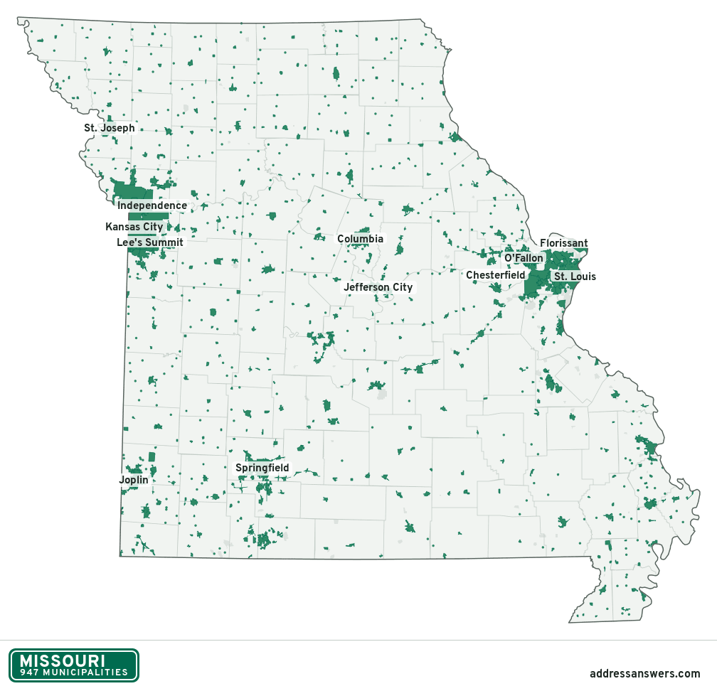
Missouri city limits map image
The map above as a picture: every Missouri municipality in green, with county lines. Boundaries from the Census Bureau, as of January 1, 2025.
You’re welcome to use it in a document or on your own site, with a link back to this page.
Download the map (PNG, 1,008 × 972)Questions about Missouri city limits
How many municipalities are in Missouri?
Missouri has 947 incorporated places: 644 cities, 196 villages, and 107 towns, by the Census Bureau’s boundary files for 2025.
What is the largest city in Missouri?
By population, Kansas City, with about 510,612 residents (2020–2024 American Community Survey 5-year estimates). It is also the largest by land area, at 314.5 square miles.
What is the smallest town in Missouri?
By the Census Bureau’s estimate, Cave, with 1 resident. Estimates for places this small have a wide margin of error, so treat it as a rough count.
How much of Missouri is unincorporated?
96% of its land and 2 million of its residents (33%) are outside every municipality. There, local government is the county. The state also has 134 named unincorporated communities; the largest is Oakville.
Is Oakville, MO a city?
No. Oakville is a census-designated place: a community the Census Bureau maps for statistics, with no city government of its own. About 35,333 people live there, in unincorporated St. Louis County. An address there is outside city limits, even if its mailing address says otherwise.
Is Mehlville, MO a city?
No. Mehlville is a census-designated place: a community the Census Bureau maps for statistics, with no city government of its own. About 29,805 people live there, in unincorporated St. Louis County. An address there is outside city limits, even if its mailing address says otherwise.
Which municipalities in Missouri are in more than one county?
55 of the 947 cross a county line, by at least 1% of their land. The largest: Kansas City (Jackson, Clay, and Platte), Lee's Summit (Jackson and Cass), and Joplin (Jasper and Newton). Check an address to see which county it’s in.
Which county in Missouri has the most municipalities?
St. Louis County, with 87 at least partly inside it. Every county in Missouri has at least one.
Bordering states
More answers for a Missouri address
Each tool checks the same address and puts its own answer first.
- County Census Your county, plus the township or town where those exist. Find your county
- School district Census The public school district that covers the address. Find your school district
- Flood zone FEMA The FEMA zone in plain English, and whether lenders require flood insurance. Check flood zone
- USDA home loans USDA Whether the property is in an area eligible for a USDA Rural Development loan. Check USDA eligibility
- Voting districts Census Your congressional district and your state senate and state house districts. Included in every check
Places, boundaries, land area and counties: US Census Bureau 2025 cartographic boundary files (boundaries as of January 1, 2025). A place is listed in each county that holds at least 1% of its land. Population: 2020–2024 American Community Survey 5-year estimates. Data updated October 24, 2026; page updated October 25, 2026. Boundaries change through annexation; your city or county has the official map.