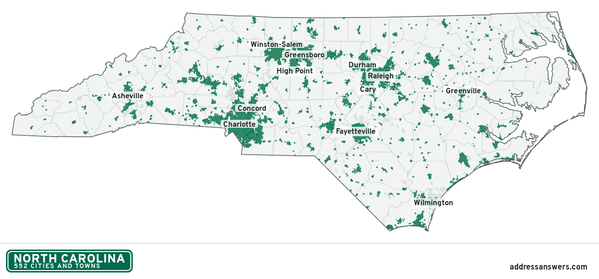
North Carolina city limits map
North Carolina has 552 incorporated places: 77 cities, 454 towns, and 21 villages. They cover 8.8% of the state’s land and are home to 58% of its residents. Everyone else lives outside city limits, where local government is the county. Enter an address to see which side of a city line it’s on.
Result for
The map couldn’t load. The answers don’t depend on it.
The boundary couldn’t load. The answer doesn’t depend on it.
Census Geocoder match
More about this address
Sources and limits
- Census
- US Census Bureau Geocoder, current boundaries
- FEMA
- National Flood Hazard Layer, effective flood maps
- USDA
- Rural Development property eligibility
- Map
- Boundaries from Census TIGERweb, flood zones drawn by FEMA, eligible areas from USDA, base map © OpenStreetMap contributors
Census boundaries are updated once a year, so a recent annexation may not show yet. Informational only, not an official determination. Verify with your city or county.
North Carolina at a glance
- Incorporated places
- 552
- 77 cities, 454 towns, and 21 villages
- Residents in city limits
- 58%
- 6,249,994 of 10,730,404
- Land in city limits
- 8.8%
- 4,281 of 48,624 sq mi
- Counties
- 100
- 3 with no city or town
- Unincorporated communities
- 224
- Largest: Murraysville (16,339)
- Largest city
- Charlotte
- 903,844 residents
How local government works in North Carolina
The Census Bureau maps 1,035 townships in North Carolina. They are geographic divisions with no government of their own. A township isn’t a city, so an address in one is outside city limits unless it’s also inside a city.
City limits maps for 10 North Carolina cities
Every North Carolina city with 100,000 or more residents has its own page: the boundary in detail, the places around it and its school districts.
All 552 cities and towns in North Carolina
Every incorporated place, largest first, with the counties it’s in and its size. An address inside one of these is inside city limits; anywhere else in the state is unincorporated.
| Name | Type | County | Population | Land (sq mi) |
|---|---|---|---|---|
| Charlotte | City | Mecklenburg | 903,844 | 312.1 |
| Raleigh | City | Wake | 481,031 | 152.3 |
| Greensboro | City | Guilford | 301,198 | 134.7 |
| Durham | City | Durham | 291,467 | 119.9 |
| Winston-Salem | City | Forsyth | 252,037 | 133.7 |
| Fayetteville | City | Cumberland | 210,815 | 148.3 |
| Cary | Town | Wake, Chatham | 179,306 | 61.1 |
| Wilmington | City | New Hanover | 120,805 | 51.4 |
| High Point | City | Guilford, Davidson | 116,245 | 57.5 |
| Concord | City | Cabarrus | 108,719 | 64.8 |
| Asheville | City | Buncombe | 94,535 | 45.5 |
| Greenville | City | Pitt | 92,857 | 38.3 |
| Gastonia | City | Gaston | 82,884 | 54.8 |
| Jacksonville | City | Onslow | 71,279 | 49.9 |
| Apex | Town | Wake, Chatham | 70,630 | 27.2 |
| Huntersville | Town | Mecklenburg | 63,969 | 42.1 |
| Chapel Hill | Town | Orange, Durham | 61,607 | 21.6 |
| Burlington | City | Alamance, Guilford | 59,610 | 31.3 |
| Kannapolis | City | Cabarrus, Rowan | 57,890 | 35.1 |
| Rocky Mount | City | Nash, Edgecombe | 54,297 | 45.2 |
| Wake Forest | Town | Wake, Franklin | 52,844 | 20.0 |
| Mooresville | Town | Iredell | 52,381 | 27.6 |
| Wilson | City | Wilson | 48,370 | 31.8 |
| Holly Springs | Town | Wake | 45,248 | 19.8 |
| Hickory | City | Catawba, Burke +1 | 44,258 | 33.2 |
| Indian Trail | Town | Union | 42,036 | 22.9 |
| Fuquay-Varina | Town | Wake | 40,485 | 19.8 |
| Monroe | City | Union | 36,759 | 32.9 |
| Salisbury | City | Rowan | 35,825 | 23.2 |
| Garner | Town | Wake | 34,473 | 20.7 |
| Goldsboro | City | Wayne | 34,383 | 28.9 |
| Cornelius | Town | Mecklenburg | 32,783 | 12.7 |
| New Bern | City | Craven | 32,734 | 28.9 |
| Sanford | City | Lee | 31,478 | 33.2 |
| Morrisville | Town | Wake, Durham | 31,422 | 9.17 |
| Matthews | Town | Mecklenburg | 30,577 | 17.1 |
| Statesville | City | Iredell | 29,894 | 30.4 |
| Leland | Town | Brunswick | 29,607 | 28.4 |
| Clayton | Town | Johnston | 29,320 | 17.2 |
| Kernersville | Town | Forsyth, Guilford | 27,830 | 19.2 |
| Asheboro | City | Randolph | 27,580 | 22.7 |
| Mint Hill | Town | Mecklenburg | 27,556 | 24.6 |
| Thomasville | City | Davidson, Randolph | 27,321 | 16.9 |
| Waxhaw | Town | Union | 22,275 | 12.9 |
| Shelby | City | Cleveland | 22,100 | 22.4 |
| Clemmons | Village | Forsyth | 21,871 | 12.0 |
| Carrboro | Town | Orange | 21,204 | 6.49 |
| Knightdale | Town | Wake | 20,214 | 10.2 |
| Boone | Town | Watauga | 20,032 | 6.39 |
| Lexington | City | Davidson | 19,690 | 19.2 |
| Harrisburg | Town | Cabarrus | 19,633 | 12.6 |
| Mebane | City | Alamance, Orange | 19,538 | 12.2 |
| Kinston | City | Lenoir | 19,505 | 18.3 |
| Elizabeth City | City | Pasquotank | 18,871 | 11.8 |
| Lumberton | City | Robeson | 18,859 | 18.2 |
| Lenoir | City | Caldwell | 18,299 | 20.8 |
| Pinehurst | Village | Moore | 18,256 | 16.7 |
| Mount Holly | City | Gaston | 18,208 | 11.3 |
| Graham | City | Alamance | 18,048 | 11.0 |
| Hope Mills | Town | Cumberland | 17,939 | 9.04 |
| Havelock | City | Craven | 17,691 | 17.1 |
| Morganton | City | Burke | 17,646 | 19.2 |
| Stallings | Town | Union, Mecklenburg | 16,886 | 8.45 |
| Albemarle | City | Stanly | 16,762 | 18.2 |
| Southern Pines | Town | Moore | 16,420 | 18.4 |
| Davidson | Town | Mecklenburg, Iredell | 15,660 | 6.50 |
| Belmont | City | Gaston | 15,546 | 12.2 |
| Hendersonville | City | Henderson | 15,408 | 8.00 |
| Eden | City | Rockingham | 15,356 | 14.2 |
| Laurinburg | City | Scotland | 15,087 | 12.5 |
| Henderson | City | Vance | 14,885 | 8.62 |
| Roanoke Rapids | City | Halifax | 14,856 | 9.91 |
| Reidsville | City | Rockingham | 14,585 | 15.2 |
| Lewisville | Town | Forsyth | 13,828 | 14.5 |
| Weddington | Town | Union | 13,805 | 17.5 |
| Newton | City | Catawba | 13,333 | 13.8 |
| Wendell | Town | Wake | 13,064 | 9.70 |
| Smithfield | Town | Johnston | 12,116 | 12.7 |
| Archdale | City | Randolph, Guilford | 12,087 | 8.98 |
| Kings Mountain | City | Cleveland, Gaston | 12,039 | 14.9 |
| Lincolnton | City | Lincoln | 11,783 | 8.96 |
| Spring Lake | Town | Cumberland | 11,573 | 23.6 |
| Summerfield | Town | Guilford | 11,116 | 26.4 |
| Pineville | Town | Mecklenburg | 11,055 | 6.64 |
| Elon | Town | Alamance | 11,032 | 4.27 |
| Tarboro | Town | Edgecombe | 10,770 | 11.3 |
| Rolesville | Town | Wake | 10,766 | 7.05 |
| Winterville | Town | Pitt | 10,725 | 4.93 |
| Mount Airy | City | Surry | 10,633 | 11.8 |
| Waynesville | Town | Haywood | 10,502 | 8.99 |
| Morehead City | Town | Carteret | 9,806 | 7.43 |
| Washington | City | Beaufort | 9,726 | 7.88 |
| Hillsborough | Town | Orange | 9,724 | 5.77 |
| Gibsonville | Town | Guilford, Alamance | 9,467 | 4.48 |
| Aberdeen | Town | Moore | 9,228 | 10.9 |
| Wesley Chapel | Village | Union | 9,090 | 9.72 |
| Oak Island | Town | Brunswick | 9,030 | 18.7 |
| Rockingham | City | Richmond | 8,967 | 7.64 |
| Oxford | City | Granville | 8,914 | 6.64 |
| Zebulon | Town | Wake | 8,711 | 6.65 |
| Conover | City | Catawba | 8,580 | 11.7 |
| Dunn | City | Harnett | 8,559 | 7.12 |
| Black Mountain | Town | Buncombe | 8,513 | 6.75 |
| Clinton | City | Sampson | 8,304 | 7.69 |
| Roxboro | City | Person | 8,182 | 7.86 |
| Fletcher | Town | Henderson | 8,098 | 6.32 |
| Butner | Town | Granville | 8,065 | 13.8 |
| Woodfin | Town | Buncombe | 8,048 | 9.53 |
| Siler City | Town | Chatham | 7,995 | 6.74 |
| Brevard | City | Transylvania | 7,897 | 5.37 |
| Kill Devil Hills | Town | Dare | 7,761 | 5.61 |
| Oak Ridge | Town | Guilford | 7,744 | 16.7 |
| Marion | City | McDowell | 7,579 | 6.85 |
| King | City | Stokes, Forsyth | 7,408 | 6.32 |
| Forest City | Town | Rutherford | 7,363 | 8.59 |
| Mills River | Town | Henderson | 7,281 | 22.4 |
| Trinity | City | Randolph | 7,111 | 16.9 |
| St. James | Town | Brunswick | 7,072 | 9.11 |
| Unionville | Town | Union | 6,954 | 29.3 |
| Selma | Town | Johnston | 6,817 | 5.55 |
| Carolina Beach | Town | New Hanover | 6,745 | 2.45 |
| Marvin | Village | Union | 6,692 | 6.01 |
| Boiling Spring Lakes | City | Brunswick | 6,347 | 23.7 |
| Angier | Town | Harnett, Wake | 6,241 | 4.59 |
| Cherryville | City | Gaston | 6,226 | 5.81 |
| Dallas | Town | Gaston | 6,104 | 3.07 |
| Mocksville | Town | Davie | 6,068 | 7.90 |
| Stokesdale | Town | Guilford | 6,004 | 19.0 |
| Hamlet | City | Richmond | 5,961 | 5.27 |
| Walkertown | Town | Forsyth | 5,873 | 6.70 |
| Locust | City | Stanly, Cabarrus | 5,840 | 8.66 |
| Nashville | Town | Nash | 5,729 | 4.70 |
| Bessemer City | City | Gaston | 5,580 | 5.73 |
| Cramerton | Town | Gaston | 5,450 | 4.65 |
| Whispering Pines | Village | Moore | 5,211 | 3.91 |
| Archer Lodge | Town | Johnston | 5,186 | 9.07 |
| Ayden | Town | Pitt | 5,150 | 3.81 |
| Williamston | Town | Martin | 5,112 | 4.51 |
| Pleasant Garden | Town | Guilford | 5,060 | 15.0 |
| Sawmills | Town | Caldwell | 5,042 | 6.61 |
| Carolina Shores | Town | Brunswick | 5,017 | 2.90 |
| Long View | Town | Catawba, Burke | 5,011 | 4.02 |
| Creedmoor | City | Granville | 4,997 | 5.45 |
| Wadesboro | Town | Anson | 4,972 | 6.60 |
| Granite Falls | Town | Caldwell | 4,929 | 4.94 |
| Holly Ridge | Town | Onslow | 4,904 | 4.40 |
| Midway | Town | Davidson | 4,897 | 7.80 |
| Midland | Town | Cabarrus | 4,860 | 13.3 |
| Ahoskie | Town | Hertford | 4,764 | 4.40 |
| Boiling Springs | Town | Cleveland | 4,757 | 4.48 |
| Pittsboro | Town | Chatham | 4,752 | 8.91 |
| Lillington | Town | Harnett | 4,709 | 8.12 |
| Valdese | Town | Burke | 4,704 | 7.86 |
| Whiteville | City | Columbus | 4,696 | 5.56 |
| Beaufort | Town | Carteret | 4,689 | 5.13 |
| Erwin | Town | Harnett | 4,687 | 4.30 |
| Weaverville | Town | Buncombe | 4,687 | 4.14 |
| Randleman | City | Randolph | 4,644 | 4.68 |
| Shallotte | Town | Brunswick | 4,639 | 9.93 |
| Ranlo | Town | Gaston | 4,617 | 2.06 |
| Raeford | City | Hoke | 4,552 | 4.28 |
| China Grove | Town | Rowan | 4,530 | 4.59 |
| Farmville | Town | Pitt | 4,514 | 3.20 |
| Edenton | Town | Chowan | 4,494 | 5.37 |
| Mount Olive | Town | Wayne | 4,453 | 2.74 |
| Newport | Town | Carteret | 4,441 | 7.83 |
| Wingate | Town | Union | 4,425 | 2.62 |
| North Wilkesboro | Town | Wilkes | 4,421 | 6.63 |
| Canton | Town | Haywood | 4,419 | 2.87 |
| Surf City | Town | Pender, Onslow | 4,396 | 7.68 |
| Sunset Beach | Town | Brunswick | 4,351 | 6.45 |
| Benson | Town | Johnston | 4,282 | 3.16 |
| Franklin | Town | Macon | 4,268 | 4.94 |
| Southport | City | Brunswick | 4,205 | 4.00 |
| Spindale | Town | Rutherford | 4,131 | 5.41 |
| Stanley | Town | Gaston | 4,069 | 3.06 |
| Elkin | Town | Surry, Wilkes | 4,043 | 6.81 |
| Trent Woods | Town | Craven | 4,032 | 2.97 |
| Swansboro | Town | Onslow | 3,997 | 2.27 |
| Troutman | Town | Iredell | 3,995 | 8.84 |
| Emerald Isle | Town | Carteret | 3,934 | 4.92 |
| Burgaw | Town | Pender | 3,850 | 4.74 |
| Maiden | Town | Catawba | 3,788 | 6.65 |
| Tabor City | Town | Columbus | 3,777 | 3.46 |
| Hudson | Town | Caldwell | 3,772 | 3.66 |
| Lowell | City | Gaston | 3,768 | 3.67 |
| Landis | Town | Rowan | 3,765 | 3.46 |
| Kitty Hawk | Town | Dare | 3,724 | 8.12 |
| Jamestown | Town | Guilford | 3,708 | 3.00 |
| Gamewell | Town | Caldwell | 3,689 | 8.11 |
| Rutherfordton | Town | Rutherford | 3,680 | 4.20 |
| Eastover | Town | Cumberland | 3,666 | 11.3 |
| Wilkesboro | Town | Wilkes | 3,646 | 6.65 |
| Fairview | Town | Union | 3,619 | 30.0 |
| Flat Rock | Village | Henderson | 3,530 | 8.09 |
| Rural Hall | Town | Forsyth | 3,466 | 2.85 |
| Wallace | Town | Duplin, Pender | 3,457 | 3.19 |
| Lake Park | Village | Union | 3,431 | 0.73 |
| Red Oak | Town | Nash | 3,405 | 19.5 |
| Spencer | Town | Rowan | 3,349 | 3.47 |
| Mineral Springs | Town | Union | 3,314 | 8.46 |
| Elizabethtown | Town | Bladen | 3,277 | 5.33 |
| Windsor | Town | Bertie | 3,269 | 2.81 |
| Louisburg | Town | Franklin | 3,263 | 3.12 |
| Plymouth | Town | Washington | 3,250 | 4.03 |
| Green Level | Town | Alamance | 3,230 | 1.50 |
| Bermuda Run | Town | Davie | 3,211 | 2.50 |
| Murfreesboro | Town | Hertford | 3,170 | 2.27 |
| Nags Head | Town | Dare | 3,160 | 6.62 |
| Wallburg | Town | Davidson | 3,150 | 5.59 |
| Southern Shores | Town | Dare | 3,139 | 3.95 |
| Red Springs | Town | Robeson | 3,125 | 3.50 |
| Granite Quarry | Town | Rowan | 3,043 | 3.05 |
| Mars Hill | Town | Madison | 3,025 | 2.10 |
| Youngsville | Town | Franklin | 3,011 | 2.58 |
| Yadkinville | Town | Yadkin | 3,004 | 2.96 |
| Troy | Town | Montgomery | 2,926 | 3.66 |
| Carthage | Town | Moore | 2,896 | 6.82 |
| River Bend | Town | Craven | 2,874 | 2.51 |
| Jonesville | Town | Yadkin | 2,860 | 2.88 |
| Haw River | Town | Alamance | 2,824 | 3.10 |
| Pembroke | Town | Robeson | 2,822 | 3.18 |
| Rockwell | Town | Rowan | 2,782 | 1.86 |
| La Grange | Town | Lenoir | 2,756 | 2.30 |
| Wilson's Mills | Town | Johnston | 2,753 | 6.62 |
| Warsaw | Town | Duplin | 2,746 | 3.22 |
| Cajah's Mountain | Town | Caldwell | 2,704 | 3.39 |
| Cape Carteret | Town | Carteret | 2,703 | 2.52 |
| Wentworth | Town | Rockingham | 2,692 | 14.2 |
| St. Pauls | Town | Robeson | 2,688 | 1.63 |
| Oakboro | Town | Stanly | 2,683 | 2.53 |
| Liberty | Town | Randolph | 2,682 | 3.21 |
| Wrightsville Beach | Town | New Hanover | 2,665 | 1.39 |
| Tobaccoville | Village | Forsyth, Stokes | 2,664 | 7.66 |
| Sylva | Town | Jackson | 2,646 | 3.17 |
| Franklinton | Town | Franklin | 2,645 | 1.83 |
| Marshville | Town | Union | 2,615 | 2.13 |
| Belville | Town | Brunswick | 2,573 | 1.67 |
| Polkton | Town | Anson | 2,555 | 3.05 |
| Swepsonville | Town | Alamance | 2,517 | 1.44 |
| Grifton | Town | Pitt, Lenoir | 2,515 | 2.68 |
| Kure Beach | Town | New Hanover | 2,466 | 0.88 |
| Fairmont | Town | Robeson | 2,463 | 2.76 |
| Four Oaks | Town | Johnston | 2,459 | 3.10 |
| Snow Hill | Town | Greene | 2,438 | 1.54 |
| Norwood | Town | Stanly | 2,433 | 4.67 |
| Connelly Springs | Town | Burke | 2,427 | 4.99 |
| Laurel Park | Town | Henderson | 2,408 | 2.82 |
| Mayodan | Town | Rockingham | 2,401 | 2.88 |
| Spruce Pine | Town | Mitchell | 2,398 | 4.06 |
| Calabash | Town | Brunswick | 2,377 | 7.30 |
| Kenly | Town | Johnston, Wilson | 2,359 | 1.90 |
| Richlands | Town | Onslow | 2,335 | 2.03 |
| Maxton | Town | Robeson, Scotland | 2,330 | 2.70 |
| Bladenboro | Town | Bladen | 2,249 | 2.22 |
| Madison | Town | Rockingham | 2,242 | 3.54 |
| Mount Pleasant | Town | Cabarrus | 2,230 | 3.62 |
| Yanceyville | Town | Caswell | 2,215 | 6.75 |
| Hildebran | Town | Burke | 2,207 | 2.83 |
| Taylorsville | Town | Alexander | 2,201 | 2.40 |
| Badin | Town | Stanly | 2,184 | 1.81 |
| Enfield | Town | Halifax | 2,153 | 1.30 |
| Ramseur | Town | Randolph | 2,150 | 2.00 |
| Drexel | Town | Burke | 2,146 | 1.38 |
| Biscoe | Town | Montgomery | 2,116 | 2.91 |
| Walnut Cove | Town | Stokes | 2,115 | 2.53 |
| Maggie Valley | Town | Haywood | 2,112 | 3.55 |
| Hemby Bridge | Town | Union | 2,096 | 2.29 |
| Burnsville | Town | Yancey | 2,082 | 1.60 |
| Navassa | Town | Brunswick | 2,039 | 13.3 |
| Pine Level | Town | Johnston | 2,031 | 2.57 |
| Manteo | Town | Dare | 2,020 | 1.88 |
| Scotland Neck | Town | Halifax | 2,006 | 1.19 |
| Andrews | Town | Cherokee | 1,998 | 1.63 |
| Glen Alpine | Town | Burke | 1,991 | 2.15 |
| Sparta | Town | Alleghany | 1,928 | 2.35 |
| Foxfire | Village | Moore | 1,925 | 7.08 |
| Claremont | City | Catawba | 1,922 | 2.89 |
| Cedar Point | Town | Carteret | 1,917 | 2.24 |
| Bryson City | Town | Swain | 1,902 | 2.20 |
| Robbins | Town | Moore | 1,893 | 1.62 |
| Jefferson | Town | Ashe | 1,864 | 2.11 |
| Tryon | Town | Polk | 1,810 | 2.00 |
| Pinebluff | Town | Moore | 1,806 | 2.62 |
| Lake Waccamaw | Town | Columbus | 1,770 | 2.80 |
| Atlantic Beach | Town | Carteret | 1,719 | 2.38 |
| Stedman | Town | Cumberland | 1,670 | 1.68 |
| Coats | Town | Harnett | 1,664 | 1.63 |
| Princeton | Town | Johnston | 1,658 | 1.29 |
| Broadway | Town | Lee | 1,657 | 1.29 |
| Dobson | Town | Surry | 1,652 | 2.03 |
| Vass | Town | Moore | 1,644 | 3.37 |
| Weldon | Town | Halifax | 1,642 | 2.92 |
| Princeville | Town | Edgecombe | 1,619 | 1.51 |
| Hertford | Town | Perquimans | 1,618 | 2.86 |
| Sharpsburg | Town | Nash, Edgecombe +1 | 1,605 | 1.01 |
| Murphy | Town | Cherokee | 1,604 | 2.57 |
| Boonville | Town | Yadkin | 1,593 | 1.20 |
| Biltmore Forest | Town | Buncombe | 1,587 | 2.91 |
| Belhaven | Town | Beaufort | 1,577 | 1.59 |
| Bethel | Town | Pitt | 1,544 | 1.05 |
| Lake Lure | Town | Rutherford | 1,543 | 13.2 |
| Stanfield | Town | Stanly | 1,522 | 4.47 |
| Denton | Town | Davidson | 1,506 | 2.10 |
| Pilot Mountain | Town | Surry | 1,483 | 2.04 |
| Banner Elk | Town | Avery | 1,473 | 1.90 |
| West Jefferson | Town | Ashe | 1,436 | 2.15 |
| East Spencer | Town | Rowan | 1,434 | 2.45 |
| Pinetops | Town | Edgecombe | 1,426 | 1.03 |
| Walnut Creek | Village | Wayne | 1,422 | 2.13 |
| Spring Hope | Town | Nash | 1,387 | 1.51 |
| Rutherford College | Town | Burke, Caldwell | 1,374 | 2.31 |
| Clyde | Town | Haywood | 1,359 | 0.86 |
| Chadbourn | Town | Columbus | 1,352 | 2.60 |
| Pine Knoll Shores | Town | Carteret | 1,351 | 2.21 |
| Rose Hill | Town | Duplin | 1,309 | 1.44 |
| Beulaville | Town | Duplin | 1,307 | 1.54 |
| Elm City | Town | Wilson, Nash | 1,292 | 2.15 |
| Star | Town | Montgomery | 1,282 | 1.29 |
| Alamance | Village | Alamance | 1,267 | 0.80 |
| Bayboro | Town | Pamlico | 1,266 | 1.86 |
| Stem | Town | Granville | 1,249 | 1.24 |
| Robersonville | Town | Martin | 1,220 | 1.21 |
| Hayesville | Town | Clay | 1,208 | 0.64 |
| Lucama | Town | Wilson | 1,205 | 0.61 |
| Mount Gilead | Town | Montgomery | 1,197 | 3.49 |
| Rhodhiss | Town | Burke, Caldwell | 1,166 | 1.19 |
| Candor | Town | Montgomery, Moore | 1,160 | 2.03 |
| Dortches | Town | Nash | 1,158 | 7.93 |
| Franklinville | Town | Randolph | 1,131 | 1.69 |
| Roseboro | Town | Sampson | 1,123 | 1.45 |
| Stoneville | Town | Rockingham | 1,094 | 1.43 |
| Kenansville | Town | Duplin | 1,090 | 2.12 |
| Norlina | Town | Warren | 1,087 | 0.99 |
| Cleveland | Town | Rowan | 1,080 | 1.55 |
| Highlands | Town | Macon, Jackson | 1,074 | 6.25 |
| Columbus | Town | Polk | 1,071 | 3.76 |
| Ellerbe | Town | Richmond | 1,036 | 1.32 |
| Vanceboro | Town | Craven | 1,030 | 1.71 |
| Magnolia | Town | Duplin | 1,024 | 1.07 |
| Maysville | Town | Jones | 1,022 | 0.86 |
| McAdenville | Town | Gaston | 1,010 | 1.36 |
| Peletier | Town | Carteret | 1,009 | 3.62 |
| Blowing Rock | Town | Watauga, Caldwell | 992 | 3.24 |
| Cooleemee | Town | Davie | 988 | 0.75 |
| Beech Mountain | Town | Watauga, Avery | 987 | 6.48 |
| Lilesville | Town | Anson | 971 | 0.99 |
| White Lake | Town | Bladen | 970 | 1.02 |
| Harmony | Town | Iredell | 967 | 1.36 |
| Holden Beach | Town | Brunswick | 962 | 2.94 |
| Marshall | Town | Madison | 961 | 3.98 |
| Stantonsburg | Town | Wilson | 958 | 0.66 |
| Rowland | Town | Robeson | 946 | 1.05 |
| Fremont | Town | Wayne | 943 | 1.43 |
| Brunswick | Town | Columbus | 937 | 0.70 |
| Richfield | Town | Stanly | 937 | 2.42 |
| Faith | Town | Rowan | 917 | 1.05 |
| Gaston | Town | Northampton | 912 | 1.69 |
| Chocowinity | Town | Beaufort | 903 | 1.00 |
| Ocean Isle Beach | Town | Brunswick | 903 | 3.39 |
| Red Cross | Town | Stanly | 903 | 3.79 |
| Ellenboro | Town | Rutherford | 901 | 1.27 |
| Belwood | Town | Cleveland | 893 | 12.3 |
| Northwest | City | Brunswick | 885 | 6.80 |
| Rich Square | Town | Northampton | 880 | 3.09 |
| Oriental | Town | Pamlico | 873 | 1.43 |
| Middlesex | Town | Nash | 867 | 1.05 |
| Newland | Town | Avery | 866 | 0.75 |
| Patterson Springs | Town | Cleveland | 845 | 1.03 |
| Conway | Town | Northampton | 832 | 1.82 |
| Hoffman | Town | Richmond | 821 | 3.40 |
| Ossipee | Town | Alamance | 795 | 0.61 |
| North Topsail Beach | Town | Onslow | 784 | 6.22 |
| Varnamtown | Town | Brunswick | 782 | 0.88 |
| Jackson | Town | Northampton | 777 | 1.01 |
| Pikeville | Town | Wayne | 776 | 0.76 |
| Sedalia | Town | Guilford | 772 | 2.00 |
| Warrenton | Town | Warren | 772 | 1.02 |
| Taylortown | Town | Moore | 764 | 1.35 |
| Sandyfield | Town | Columbus | 763 | 3.16 |
| Columbia | Town | Tyrrell | 759 | 1.23 |
| Bogue | Town | Carteret | 756 | 2.75 |
| Wagram | Town | Scotland | 754 | 1.46 |
| Black Creek | Town | Wilson | 749 | 0.71 |
| Bakersville | Town | Mitchell | 747 | 0.76 |
| Gibson | Town | Scotland | 745 | 0.98 |
| Clarkton | Town | Bladen | 740 | 1.25 |
| Lawndale | Town | Cleveland | 739 | 0.81 |
| East Bend | Town | Yadkin | 715 | 1.31 |
| Alliance | Town | Pamlico | 709 | 2.09 |
| Garland | Town | Sampson | 704 | 1.08 |
| Rosman | Town | Transylvania | 699 | 0.56 |
| Winfall | Town | Perquimans | 697 | 2.31 |
| Fair Bluff | Town | Columbus | 695 | 2.36 |
| Aulander | Town | Bertie | 689 | 1.48 |
| Saluda | City | Polk, Henderson | 683 | 1.56 |
| Duck | Town | Dare | 669 | 2.42 |
| Faison | Town | Duplin | 660 | 0.87 |
| Misenheimer | Village | Stanly | 659 | 1.62 |
| Ansonville | Town | Anson | 651 | 1.47 |
| Grimesland | Town | Pitt | 650 | 0.68 |
| Greenevers | Town | Duplin | 648 | 1.59 |
| Grantsboro | Town | Pamlico | 645 | 3.85 |
| Montreat | Town | Buncombe | 630 | 2.73 |
| Catawba | Town | Catawba | 628 | 4.63 |
| Grover | Town | Cleveland | 621 | 0.96 |
| Fallston | Town | Cleveland | 616 | 2.16 |
| New London | Town | Stanly | 608 | 1.98 |
| Minnesott Beach | Town | Pamlico | 593 | 3.47 |
| Winton | Town | Hertford | 593 | 0.84 |
| Seaboard | Town | Northampton | 585 | 0.96 |
| Robbinsville | Town | Graham | 577 | 0.66 |
| Hookerton | Town | Greene | 573 | 0.37 |
| Micro | Town | Johnston | 573 | 0.53 |
| Garysburg | Town | Northampton | 572 | 0.94 |
| Whitsett | Town | Guilford | 569 | 2.58 |
| Hot Springs | Town | Madison | 567 | 2.87 |
| Conetoe | Town | Edgecombe | 561 | 0.34 |
| Aurora | Town | Beaufort | 560 | 0.93 |
| Dobbins Heights | Town | Richmond | 560 | 0.88 |
| Elk Park | Town | Avery | 560 | 0.69 |
| Old Fort | Town | McDowell | 555 | 1.22 |
| Salemburg | Town | Sampson | 550 | 1.05 |
| Littleton | Town | Halifax | 549 | 0.95 |
| St. Helena | Village | Pender | 544 | 5.64 |
| Sugar Mountain | Village | Avery | 539 | 2.46 |
| Polkville | City | Cleveland | 536 | 1.86 |
| High Shoals | City | Gaston | 534 | 2.60 |
| Parkton | Town | Robeson | 529 | 0.78 |
| Pink Hill | Town | Lenoir | 527 | 0.46 |
| Lattimore | Town | Cleveland | 526 | 1.03 |
| Sims | Town | Wilson | 522 | 0.24 |
| Wade | Town | Cumberland | 518 | 1.75 |
| Ruth | Town | Rutherford | 510 | 0.42 |
| Bolton | Town | Columbus | 504 | 3.25 |
| Cove City | Town | Craven | 504 | 0.64 |
| Newton Grove | Town | Sampson | 498 | 3.08 |
| Woodland | Town | Northampton | 497 | 1.25 |
| Whitakers | Town | Nash, Edgecombe | 494 | 0.83 |
| Pantego | Town | Beaufort | 493 | 0.80 |
| Caswell Beach | Town | Brunswick | 491 | 3.07 |
| Atkinson | Town | Pender | 485 | 0.99 |
| Webster | Town | Jackson | 470 | 1.00 |
| Bunn | Town | Franklin | 466 | 0.59 |
| Pollocksville | Town | Jones | 463 | 0.31 |
| Jamesville | Town | Martin | 457 | 1.46 |
| Staley | Town | Randolph | 456 | 1.16 |
| Washington Park | Town | Beaufort | 456 | 0.26 |
| Lewiston Woodville | Town | Bertie | 447 | 1.96 |
| East Arcadia | Town | Bladen | 444 | 2.20 |
| Bethania | Town | Forsyth | 443 | 0.68 |
| Peachland | Town | Anson | 443 | 1.01 |
| Ronda | Town | Wilkes | 436 | 1.08 |
| Bostic | Town | Rutherford | 433 | 0.93 |
| Simpson | Village | Pitt | 432 | 0.37 |
| Bridgeton | Town | Craven | 427 | 2.05 |
| Teachey | Town | Duplin | 427 | 1.05 |
| Seven Devils | Town | Watauga, Avery | 425 | 2.19 |
| Bailey | Town | Nash | 422 | 0.70 |
| Fountain | Town | Pitt | 409 | 0.92 |
| Seagrove | Town | Randolph | 407 | 1.15 |
| Topsail Beach | Town | Pender | 406 | 4.39 |
| Dover | Town | Craven | 404 | 0.96 |
| Momeyer | Town | Nash | 398 | 1.10 |
| Arapahoe | Town | Pamlico | 397 | 2.17 |
| Bath | Town | Beaufort | 391 | 0.36 |
| Macclesfield | Town | Edgecombe | 391 | 0.54 |
| Turkey | Town | Sampson | 391 | 0.40 |
| Brookford | Town | Catawba | 390 | 0.61 |
| Calypso | Town | Duplin | 385 | 1.00 |
| Roper | Town | Washington | 384 | 0.86 |
| Kingstown | Town | Cleveland | 381 | 1.76 |
| Goldston | Town | Chatham | 379 | 1.06 |
| Parmele | Town | Martin | 374 | 1.16 |
| Casar | Town | Cleveland | 373 | 1.75 |
| Cameron | Town | Moore | 364 | 1.21 |
| Morven | Town | Anson | 362 | 1.03 |
| Oak City | Town | Martin | 353 | 1.00 |
| Dublin | Town | Bladen | 349 | 0.44 |
| Forest Hills | Village | Jackson | 329 | 0.50 |
| Roxobel | Town | Bertie | 326 | 1.04 |
| Gatesville | Town | Gates | 320 | 0.40 |
| Cerro Gordo | Town | Columbus | 319 | 0.79 |
| Trenton | Town | Jones | 319 | 0.24 |
| Walstonburg | Town | Greene | 313 | 0.39 |
| Earl | Town | Cleveland | 309 | 0.86 |
| Cedar Rock | Village | Caldwell | 306 | 1.14 |
| Cofield | Village | Hertford | 300 | 3.14 |
| Sandy Creek | Town | Brunswick | 300 | 1.46 |
| Halifax | Town | Halifax | 294 | 0.46 |
| Rennert | Town | Robeson | 292 | 1.10 |
| Saratoga | Town | Wilson | 291 | 0.63 |
| Powellsville | Town | Bertie | 277 | 0.36 |
| Falcon | Town | Cumberland, Sampson | 272 | 1.41 |
| Watha | Town | Pender | 271 | 1.36 |
| Bolivia | Town | Brunswick | 247 | 0.62 |
| Castalia | Town | Nash | 247 | 0.76 |
| Hamilton | Town | Martin | 243 | 0.49 |
| Colerain | Town | Bertie | 239 | 0.26 |
| Stovall | Town | Granville | 235 | 1.28 |
| Eureka | Town | Wayne | 224 | 0.34 |
| Creswell | Town | Washington | 217 | 0.57 |
| Indian Beach | Town | Carteret | 211 | 0.57 |
| Boardman | Town | Columbus | 210 | 3.09 |
| Vandemere | Town | Pamlico | 209 | 1.52 |
| Hobgood | Town | Halifax | 207 | 1.03 |
| Mesic | Town | Pamlico | 205 | 1.03 |
| Godwin | Town | Cumberland | 203 | 0.67 |
| Danbury | Town | Stokes | 197 | 0.75 |
| Harrellsville | Town | Hertford | 196 | 0.29 |
| Dillsboro | Town | Jackson | 195 | 0.48 |
| Everetts | Town | Martin | 193 | 0.49 |
| Bald Head Island | Village | Brunswick | 190 | 3.88 |
| Mooresboro | Town | Cleveland | 190 | 1.77 |
| Autryville | Town | Sampson | 177 | 0.52 |
| Kelford | Town | Bertie | 177 | 0.48 |
| Harrells | Town | Sampson | 175 | 3.15 |
| Waco | Town | Cleveland | 171 | 0.84 |
| Lansing | Town | Ashe | 165 | 0.37 |
| McFarlan | Town | Anson | 164 | 0.92 |
| Love Valley | Town | Iredell | 159 | 1.02 |
| Severn | Town | Northampton | 158 | 1.01 |
| Askewville | Town | Bertie | 155 | 0.59 |
| Lasker | Town | Northampton | 152 | 1.12 |
| Middleburg | Town | Vance | 141 | 0.79 |
| Bear Grass | Town | Martin | 133 | 0.25 |
| Milton | Town | Caswell | 133 | 0.36 |
| Stonewall | Town | Pamlico | 131 | 1.71 |
| Linden | Town | Cumberland | 129 | 0.55 |
| Como | Town | Hertford | 123 | 3.15 |
| Chimney Rock Village | Village | Rutherford | 122 | 3.36 |
| Falkland | Town | Pitt | 120 | 0.23 |
| Crossnore | Town | Avery | 115 | 0.45 |
| Proctorville | Town | Robeson | 109 | 0.45 |
| Marietta | Town | Robeson | 106 | 1.12 |
| McDonald | Town | Robeson | 106 | 0.26 |
| Norman | Town | Richmond | 89 | 0.56 |
| Lake Santeetlah | Town | Graham | 82 | 0.19 |
| Lumber Bridge | Town | Robeson | 75 | 0.67 |
| Tar Heel | Town | Bladen | 69 | 0.23 |
| Macon | Town | Warren | 66 | 0.50 |
| Speed | Town | Edgecombe | 64 | 0.30 |
| Kittrell | Town | Vance | 57 | 0.21 |
| Orrum | Town | Robeson | 56 | 0.48 |
| Hassell | Town | Martin | 45 | 0.27 |
| Leggett | Town | Edgecombe | 43 | 0.78 |
| Raynham | Town | Robeson | 42 | 0.12 |
| Seven Springs | Town | Wayne | 32 | 0.34 |
| Dellview | Town | Gaston | 26 | 0.11 |
| Grandfather Village | Village | Avery | 14 | 1.55 |
| Fontana Dam | Town | Graham | 0 | 0.62 |
| Spencer Mountain | Town | Gaston | 0 | 0.49 |
Showing 1–50 of 552
Unincorporated communities in North Carolina
Census-designated places: named communities the Census Bureau maps for statistics, with no city government of their own. An address in one is outside city limits, even when its mailing address names a city. North Carolina has 224.
| Community | County | Population | Land (sq mi) |
|---|---|---|---|
| Murraysville | New Hanover | 16,339 | 8.61 |
| Piney Green | Onslow | 14,078 | 13.4 |
| Anderson Creek | Harnett | 13,927 | 20.2 |
| Myrtle Grove | New Hanover | 12,637 | 6.71 |
| Lake Norman of Iredell | Iredell | 12,494 | 10.1 |
| Spout Springs | Harnett | 11,242 | 10.4 |
| Lake Norman of Catawba | Catawba | 9,906 | 24.1 |
| St. Stephens | Catawba | 9,457 | 9.03 |
| Hampstead | Pender | 9,292 | 20.2 |
| Kings Grant | New Hanover | 9,003 | 4.53 |
| Ogden | New Hanover | 8,249 | 4.53 |
| Cullowhee | Jackson | 7,973 | 3.81 |
| Etowah | Henderson | 7,968 | 17.7 |
| Porters Neck | New Hanover | 7,654 | 5.41 |
| Half Moon | Onslow | 7,378 | 7.39 |
| Swannanoa | Buncombe | 6,901 | 6.37 |
| Silver Lake | New Hanover | 6,563 | 2.47 |
| East Flat Rock | Henderson | 6,323 | 4.19 |
| Wrightsboro | New Hanover | 6,287 | 11.1 |
| Briar Chapel | Chatham | 6,049 | 2.09 |
| Westport | Lincoln | 5,915 | 3.67 |
| Barbecue | Harnett | 5,910 | 5.67 |
| Northchase | New Hanover | 5,896 | 1.72 |
| Moyock | Currituck | 5,684 | 10.4 |
| James City | Craven | 4,789 | 7.70 |
| Seven Lakes | Moore | 4,535 | 8.39 |
| Royal Pines | Buncombe | 4,325 | 2.71 |
| Forest Oaks | Guilford | 4,293 | 4.80 |
| Dana | Henderson | 4,147 | 8.91 |
| Bethlehem | Alexander | 4,101 | 7.62 |
| Mountain View | Catawba | 3,982 | 4.66 |
| Lowesville | Lincoln | 3,874 | 6.80 |
| Tyro | Davidson | 3,833 | 12.8 |
| Skippers Corner | New Hanover | 3,792 | 7.01 |
| Buies Creek | Harnett | 3,746 | 3.03 |
| Rockfish | Hoke | 3,574 | 4.95 |
| Welcome | Davidson | 3,521 | 9.31 |
| Glen Raven | Alamance | 3,506 | 3.30 |
| Mountain Home | Henderson | 3,437 | 3.77 |
| Brices Creek | Craven | 3,415 | 7.85 |
| River Road | Beaufort | 3,366 | 7.09 |
| Enochville | Rowan | 3,321 | 3.83 |
| Elroy | Wayne | 3,251 | 6.52 |
| Lake Junaluska | Haywood | 3,175 | 5.29 |
| Lake Royale | Franklin | 3,168 | 6.51 |
| Bayshore | New Hanover | 2,949 | 2.33 |
| Fairfield Harbour | Craven | 2,948 | 2.88 |
| Avery Creek | Buncombe | 2,887 | 1.73 |
| Mar-Mac | Wayne | 2,877 | 4.55 |
| East Rockingham | Richmond | 2,779 | 3.42 |
| Brogden | Wayne | 2,733 | 2.22 |
| Sneads Ferry | Onslow | 2,728 | 3.80 |
| Edneyville | Henderson | 2,716 | 10.7 |
| Valley Hill | Henderson | 2,675 | 2.32 |
| Neuse Forest | Craven | 2,671 | 3.16 |
| Emma | Buncombe | 2,657 | 1.09 |
| Denver | Lincoln | 2,497 | 5.93 |
| South Rosemary | Halifax | 2,475 | 6.12 |
| Fruitland | Henderson | 2,398 | 8.05 |
| Salem | Burke | 2,377 | 4.29 |
| Fearrington Village | Chatham | 2,356 | 1.79 |
| Cricket | Wilkes | 2,317 | 3.54 |
| Dudley | Wayne | 2,305 | 2.76 |
| Fairview | Buncombe | 2,298 | 6.22 |
| Governors Village | Chatham | 2,295 | 0.45 |
| Grandy | Currituck | 2,245 | 6.77 |
| Icard | Burke | 2,153 | 3.83 |
| Cherokee | Swain | 2,059 | 12.1 |
| Mulberry | Wilkes | 2,037 | 5.09 |
| Wanchese | Dare | 1,956 | 4.67 |
| Vander | Cumberland | 1,922 | 3.71 |
| Sea Breeze | New Hanover | 1,849 | 1.86 |
| Broad Creek | Carteret | 1,836 | 3.11 |
| Fairplains | Wilkes | 1,803 | 4.21 |
| Governors Club | Chatham | 1,787 | 2.35 |
| Plain View | Sampson | 1,741 | 16.7 |
| Northlakes | Caldwell | 1,716 | 1.49 |
| Millers Creek | Wilkes | 1,689 | 4.48 |
| Cherry Branch | Craven | 1,684 | 1.15 |
| Hoopers Creek | Henderson | 1,683 | 6.95 |
| Nebo | McDowell | 1,670 | 5.30 |
| Pumpkin Center | Onslow | 1,636 | 1.27 |
| Cove Creek | Watauga | 1,629 | 8.54 |
| Efland | Orange | 1,611 | 1.78 |
| Gorman | Durham | 1,591 | 2.80 |
| Southmont | Davidson | 1,525 | 4.56 |
| Horse Shoe | Henderson | 1,490 | 7.46 |
| New Hope | Wayne | 1,487 | 2.53 |
| West Canton | Haywood | 1,412 | 1.35 |
| Advance | Davie | 1,408 | 7.16 |
| Bent Creek | Buncombe | 1,384 | 2.21 |
| Cordova | Richmond | 1,372 | 2.13 |
| Stony Point | Alexander | 1,372 | 2.98 |
| Maury | Greene | 1,339 | 1.05 |
| Brandywine Bay | Carteret | 1,313 | 0.80 |
| Saxapahaw | Alamance | 1,301 | 5.18 |
| Moravian Falls | Wilkes | 1,285 | 5.12 |
| Buxton | Dare | 1,267 | 7.84 |
| Arrowhead Beach | Chowan | 1,242 | 0.61 |
| Foscoe | Watauga | 1,226 | 5.78 |
| Barker Ten Mile | Robeson | 1,156 | 2.28 |
| Balfour | Henderson | 1,134 | 1.62 |
| Camden | Camden | 1,115 | 1.58 |
| Germanton | Stokes | 1,087 | 1.75 |
| Woodlawn | Alamance | 1,085 | 3.29 |
| Springdale | Gaston | 1,075 | 0.71 |
| Barker Heights | Henderson | 1,074 | 0.98 |
| West Marion | McDowell | 1,066 | 1.51 |
| Bonnetsville | Sampson | 1,063 | 3.31 |
| Flat Rock | Surry | 1,062 | 2.61 |
| Harkers Island | Carteret | 1,060 | 2.24 |
| Hays | Wilkes | 1,053 | 6.16 |
| Cypress Landing | Beaufort | 1,044 | 2.36 |
| Moncure | Chatham | 1,039 | 4.73 |
| Rocky Point | Pender | 1,020 | 6.90 |
| Laurel Hill | Scotland | 986 | 2.40 |
| South Henderson | Vance | 981 | 1.80 |
| Spivey's Corner | Sampson | 954 | 7.77 |
| Five Points | Hoke | 940 | 8.28 |
| Iron Station | Lincoln | 934 | 2.36 |
| Manns Harbor | Dare | 926 | 3.99 |
| Gold Hill | Rowan | 914 | 2.49 |
| Prospect | Robeson | 907 | 3.93 |
| Castle Hayne | New Hanover | 897 | 4.76 |
| Toast | Surry | 893 | 1.47 |
| Bunnlevel | Harnett | 844 | 7.57 |
| Hollister | Halifax | 819 | 3.94 |
| White Plains | Surry | 795 | 4.01 |
| Jackson Heights | Lenoir | 794 | 1.45 |
| Pleasant Hill | Wilkes | 793 | 2.58 |
| Rodanthe | Dare | 781 | 0.96 |
| Ocracoke | Hyde | 723 | 8.60 |
| Deercroft | Scotland | 718 | 1.29 |
| JAARS | Union | 715 | 0.86 |
| Rougemont | Durham | 703 | 6.31 |
| McLeansville | Guilford | 688 | 6.13 |
| Cashiers | Jackson | 683 | 4.10 |
| Mamers | Harnett | 669 | 6.04 |
| Frisco | Dare | 664 | 4.84 |
| Deep Run | Lenoir | 662 | 2.84 |
| Riegelwood | Columbus | 649 | 3.08 |
| Alexis | Gaston | 635 | 1.98 |
| Kelly | Bladen | 616 | 11.6 |
| Ingold | Sampson | 599 | 5.18 |
| Potters Hill | Duplin | 595 | 5.35 |
| Silver City | Hoke | 592 | 1.49 |
| Carolina Meadows | Chatham | 555 | 0.39 |
| Coinjock | Currituck | 543 | 0.84 |
| Pinnacle | Stokes | 540 | 3.61 |
| Atlantic | Carteret | 522 | 0.92 |
| Millingport | Stanly | 522 | 5.68 |
| Cape Colony | Chowan | 509 | 1.01 |
| South Weldon | Halifax | 500 | 0.44 |
| Altamahaw | Alamance | 491 | 1.36 |
| Marble | Cherokee | 472 | 1.09 |
| Swan Quarter | Hyde | 458 | 3.95 |
| Barnardsville | Buncombe | 445 | 3.53 |
| Cliffside | Rutherford | 438 | 2.33 |
| Ruffin | Rockingham | 423 | 4.55 |
| Evergreen | Columbus | 421 | 3.84 |
| Farmington | Davie | 409 | 1.62 |
| Crouse | Lincoln | 408 | 1.14 |
| Yadkin College | Davidson | 400 | 2.88 |
| Marshallberg | Carteret | 398 | 0.64 |
| Hightsville | New Hanover | 397 | 1.46 |
| Gloucester | Carteret | 385 | 1.44 |
| Bell Arthur | Pitt | 374 | 1.86 |
| Scotch Meadows | Scotland | 370 | 0.34 |
| Avon | Dare | 339 | 2.27 |
| Chowan Beach | Chowan | 325 | 0.16 |
| Hallsboro | Columbus | 291 | 3.28 |
| Linville | Avery | 291 | 1.78 |
| Hiddenite | Alexander | 290 | 1.59 |
| Raemon | Robeson | 288 | 4.31 |
| Ashley Heights | Hoke | 282 | 2.24 |
| Roberdel | Richmond | 279 | 0.66 |
| Light Oak | Cleveland | 277 | 1.44 |
| Ivanhoe | Sampson | 275 | 5.02 |
| Belvoir | Pitt | 272 | 1.98 |
| Keener | Sampson | 271 | 11.2 |
| Lowgap | Surry | 264 | 1.14 |
| Bennett | Chatham | 262 | 3.20 |
| Davis | Carteret | 261 | 2.18 |
| Delco | Columbus | 258 | 1.51 |
| Bayview | Beaufort | 253 | 1.06 |
| Sunbury | Gates | 251 | 2.45 |
| Jackson Springs | Moore | 250 | 1.60 |
| Elrod | Robeson | 246 | 5.34 |
| Valle Crucis | Watauga | 242 | 4.44 |
| South Mills | Camden | 230 | 1.79 |
| Glenwood | McDowell | 226 | 1.61 |
| Salvo | Dare | 220 | 0.97 |
| Smithtown | Yadkin | 211 | 1.34 |
| Stokes | Pitt | 210 | 4.44 |
| Long Creek | Pender | 206 | 2.01 |
| Centerville | Franklin | 202 | 1.63 |
| Henrietta | Rutherford | 197 | 0.58 |
| White Oak | Bladen | 191 | 5.11 |
| Vann Crossroads | Sampson | 187 | 4.56 |
| Gulf | Chatham | 178 | 0.91 |
| Engelhard | Hyde | 174 | 3.23 |
| Delway | Sampson | 167 | 9.61 |
| Aquadale | Stanly | 156 | 3.26 |
| Waves | Dare | 153 | 0.68 |
| Hatteras | Dare | 152 | 1.58 |
| Wakulla | Robeson | 142 | 0.86 |
| Milwaukee | Northampton | 139 | 1.72 |
| Glenville | Jackson | 138 | 1.34 |
| Old Hundred | Scotland | 131 | 0.97 |
| Shannon | Robeson | 125 | 1.02 |
| Bowdens | Duplin | 122 | 1.36 |
| Caroleen | Rutherford | 116 | 1.11 |
| Gerton | Henderson | 110 | 3.72 |
| Blue Clay Farms | New Hanover | 94 | 2.44 |
| Bowmore | Hoke | 88 | 3.32 |
| Chinquapin | Duplin | 83 | 1.39 |
| Fairfield | Hyde | 81 | 7.04 |
| Butters | Bladen | 62 | 1.48 |
| Rex | Robeson | 59 | 0.74 |
| Graingers | Lenoir | 27 | 1.65 |
| Pinetown | Beaufort | 19 | 1.02 |
| Hobucken | Pamlico | 5 | 5.08 |
| Dundarrach | Hoke | 0 | 1.32 |
| Whittier | Jackson | 0 | 0.18 |
Showing 1–50 of 224
Counties in North Carolina
100 counties, with how many cities and towns have land in each and the largest whose main county it is.
| County | Cities | Largest | Population | Land (sq mi) |
|---|---|---|---|---|
| Wake County | 13 | Raleigh | 1,178,653 | 834.8 |
| Mecklenburg County | 8 | Charlotte | 1,154,681 | 523.6 |
| Guilford County | 13 | Greensboro | 547,940 | 646.0 |
| Forsyth County | 9 | Winston-Salem | 389,977 | 408.0 |
| Cumberland County | 9 | Fayetteville | 338,545 | 652.6 |
| Durham County | 3 | Durham | 332,353 | 287.6 |
| Buncombe County | 6 | Asheville | 274,360 | 656.5 |
| Union County | 14 | Indian Trail | 250,958 | 632.7 |
| Cabarrus County | 6 | Concord | 236,133 | 361.2 |
| New Hanover County | 4 | Wilmington | 235,229 | 192.3 |
| Gaston County | 15 | Gastonia | 234,881 | 355.8 |
| Johnston County | 11 | Clayton | 234,263 | 792.0 |
| Onslow County | 6 | Jacksonville | 207,906 | 762.1 |
| Iredell County | 6 | Mooresville | 196,544 | 574.5 |
| Pitt County | 10 | Greenville | 177,193 | 652.4 |
| Alamance County | 10 | Burlington | 176,893 | 423.5 |
| Davidson County | 6 | Thomasville | 172,954 | 553.0 |
| Catawba County | 8 | Hickory | 163,573 | 401.4 |
| Brunswick County | 19 | Leland | 152,568 | 849.5 |
| Rowan County | 10 | Salisbury | 149,875 | 511.6 |
| Orange County | 4 | Chapel Hill | 149,678 | 397.6 |
| Randolph County | 10 | Asheboro | 146,348 | 782.3 |
| Harnett County | 5 | Dunn | 139,150 | 595.1 |
| Wayne County | 7 | Goldsboro | 118,652 | 553.9 |
| Henderson County | 6 | Hendersonville | 118,484 | 372.9 |
| Robeson County | 15 | Lumberton | 116,902 | 947.3 |
| Moore County | 12 | Pinehurst | 104,876 | 697.6 |
| Craven County | 8 | New Bern | 102,612 | 706.5 |
| Cleveland County | 15 | Shelby | 100,991 | 464.3 |
| Nash County | 12 | Rocky Mount | 96,216 | 540.4 |
| Lincoln County | 1 | Lincolnton | 92,716 | 295.9 |
| Rockingham County | 6 | Eden | 92,131 | 565.6 |
| Burke County | 10 | Morganton | 87,795 | 506.2 |
| Caldwell County | 11 | Lenoir | 80,536 | 471.9 |
| Chatham County | 5 | Siler City | 80,151 | 681.5 |
| Wilson County | 9 | Wilson | 79,290 | 367.6 |
| Franklin County | 5 | Louisburg | 74,386 | 491.9 |
| Surry County | 4 | Mount Airy | 71,425 | 532.6 |
| Carteret County | 11 | Morehead City | 69,148 | 507.6 |
| Wilkes County | 4 | North Wilkesboro | 65,935 | 753.7 |
| Lee County | 2 | Sanford | 65,816 | 255.1 |
| Pender County | 7 | Surf City | 65,550 | 871.3 |
| Rutherford County | 8 | Forest City | 64,930 | 565.4 |
| Stanly County | 10 | Albemarle | 64,651 | 395.1 |
| Haywood County | 4 | Waynesville | 62,662 | 553.6 |
| Granville County | 5 | Oxford | 60,877 | 532.0 |
| Sampson County | 9 | Clinton | 59,470 | 945.9 |
| Watauga County | 4 | Boone | 55,123 | 312.4 |
| Lenoir County | 4 | Kinston | 54,919 | 399.1 |
| Hoke County | 1 | Raeford | 53,835 | 390.2 |
| Columbus County | 10 | Whiteville | 50,140 | 938.2 |
| Duplin County | 10 | Wallace | 49,335 | 814.7 |
| Edgecombe County | 10 | Tarboro | 48,736 | 505.4 |
| Halifax County | 7 | Roanoke Rapids | 47,675 | 723.7 |
| Stokes County | 4 | King | 45,139 | 449.3 |
| McDowell County | 2 | Marion | 44,817 | 440.0 |
| Beaufort County | 7 | Washington | 44,499 | 832.7 |
| Davie County | 3 | Mocksville | 44,122 | 263.7 |
| Jackson County | 5 | Sylva | 43,771 | 491.1 |
| Richmond County | 6 | Rockingham | 42,344 | 473.7 |
| Vance County | 3 | Henderson | 42,322 | 252.4 |
| Pasquotank County | 1 | Elizabeth City | 40,834 | 226.9 |
| Person County | 1 | Roxboro | 39,542 | 392.3 |
| Macon County | 2 | Franklin | 37,941 | 515.5 |
| Dare County | 6 | Kill Devil Hills | 37,875 | 383.2 |
| Yadkin County | 4 | Yadkinville | 37,574 | 334.9 |
| Alexander County | 1 | Taylorsville | 36,412 | 260.0 |
| Transylvania County | 2 | Brevard | 33,691 | 378.4 |
| Scotland County | 4 | Laurinburg | 33,590 | 319.1 |
| Currituck County | 0 | None | 30,601 | 261.9 |
| Bladen County | 7 | Elizabethtown | 29,566 | 875.0 |
| Cherokee County | 2 | Andrews | 29,562 | 455.5 |
| Ashe County | 3 | Jefferson | 26,950 | 426.3 |
| Montgomery County | 5 | Troy | 26,007 | 491.5 |
| Caswell County | 2 | Yanceyville | 22,404 | 425.5 |
| Anson County | 7 | Wadesboro | 22,289 | 531.5 |
| Madison County | 3 | Mars Hill | 21,867 | 449.6 |
| Martin County | 9 | Williamston | 21,644 | 456.4 |
| Greene County | 3 | Snow Hill | 20,486 | 266.7 |
| Hertford County | 6 | Ahoskie | 19,908 | 353.2 |
| Polk County | 3 | Tryon | 19,891 | 237.7 |
| Yancey County | 1 | Burnsville | 18,797 | 312.6 |
| Warren County | 3 | Norlina | 18,795 | 429.4 |
| Avery County | 8 | Banner Elk | 17,680 | 247.3 |
| Bertie County | 8 | Windsor | 17,170 | 699.2 |
| Northampton County | 9 | Gaston | 16,931 | 536.7 |
| Mitchell County | 2 | Spruce Pine | 14,992 | 221.3 |
| Swain County | 1 | Bryson City | 14,013 | 527.7 |
| Chowan County | 1 | Edenton | 13,836 | 172.7 |
| Perquimans County | 2 | Hertford | 13,244 | 247.2 |
| Pamlico County | 9 | Bayboro | 12,390 | 336.5 |
| Clay County | 1 | Hayesville | 11,610 | 215.0 |
| Alleghany County | 1 | Sparta | 11,174 | 234.8 |
| Camden County | 0 | None | 10,927 | 240.3 |
| Washington County | 3 | Plymouth | 10,812 | 346.5 |
| Gates County | 1 | Gatesville | 10,376 | 340.6 |
| Jones County | 3 | Maysville | 9,302 | 471.4 |
| Graham County | 3 | Robbinsville | 8,072 | 292.0 |
| Hyde County | 0 | None | 4,592 | 612.3 |
| Tyrrell County | 1 | Columbia | 3,423 | 390.8 |
Showing 1–50 of 100
North Carolina city limits map image
The map above as a picture: every North Carolina city and town in green, with county lines. Boundaries from the Census Bureau, as of January 1, 2025.
You’re welcome to use it in a document or on your own site, with a link back to this page.
Download the map (PNG, 1,200 × 559)Questions about North Carolina city limits
How many cities and towns are in North Carolina?
North Carolina has 552 incorporated places: 77 cities, 454 towns, and 21 villages, by the Census Bureau’s boundary files for 2025.
What is the largest city in North Carolina?
By population, Charlotte, with about 903,844 residents (2020–2024 American Community Survey 5-year estimates). It is also the largest by land area, at 312.1 square miles.
What is the smallest village in North Carolina?
By the Census Bureau’s estimate, Grandfather Village, with 14 residents. Estimates for places this small have a wide margin of error, so treat it as a rough count.
How much of North Carolina is unincorporated?
91% of its land and 4.5 million of its residents (42%) are outside every city or town. There, local government is the county. The state also has 224 named unincorporated communities; the largest is Murraysville.
Is Murraysville, NC a city?
No. Murraysville is a census-designated place: a community the Census Bureau maps for statistics, with no city government of its own. About 16,339 people live there, in unincorporated New Hanover County. An address there is outside city limits, even if its mailing address says otherwise.
Is Piney Green, NC a city?
No. Piney Green is a census-designated place: a community the Census Bureau maps for statistics, with no city government of its own. About 14,078 people live there, in unincorporated Onslow County. An address there is outside city limits, even if its mailing address says otherwise.
Which cities and towns in North Carolina are in more than one county?
41 of the 552 cross a county line, by at least 1% of their land. The largest: Cary (Wake and Chatham), High Point (Guilford and Davidson), and Apex (Wake and Chatham). Check an address to see which county it’s in.
Which county in North Carolina has the most cities and towns?
Brunswick County, with 19 at least partly inside it. Camden County, Currituck County, and Hyde County have none.
Bordering states
More answers for a North Carolina address
Each tool checks the same address and puts its own answer first.
- County Census Your county, plus the township or town where those exist. Find your county
- School district Census The public school district that covers the address. Find your school district
- Flood zone FEMA The FEMA zone in plain English, and whether lenders require flood insurance. Check flood zone
- USDA home loans USDA Whether the property is in an area eligible for a USDA Rural Development loan. Check USDA eligibility
- Voting districts Census Your congressional district and your state senate and state house districts. Included in every check
Places, boundaries, land area and counties: US Census Bureau 2025 cartographic boundary files (boundaries as of January 1, 2025). A place is listed in each county that holds at least 1% of its land. Population: 2020–2024 American Community Survey 5-year estimates. Data updated October 24, 2026; page updated October 25, 2026. Boundaries change through annexation; your city or county has the official map.