Georgia city limits map
Georgia has 538 incorporated places: 436 cities and 102 towns. They cover 9.5% of the state’s land and are home to 45% of its residents. Everyone else lives outside city limits, where local government is the county. Enter an address to see which side of a city line it’s on.
Result for
The map couldn’t load. The answers don’t depend on it.
The boundary couldn’t load. The answer doesn’t depend on it.
Census Geocoder match
More about this address
Sources and limits
- Census
- US Census Bureau Geocoder, current boundaries
- FEMA
- National Flood Hazard Layer, effective flood maps
- USDA
- Rural Development property eligibility
- Map
- Boundaries from Census TIGERweb, flood zones drawn by FEMA, eligible areas from USDA, base map © OpenStreetMap contributors
Census boundaries are updated once a year, so a recent annexation may not show yet. Informational only, not an official determination. Verify with your city or county.
Georgia at a glance
- Incorporated places
- 538
- 436 cities and 102 towns
- Residents in city limits
- 45%
- 4,974,846 of 10,940,407
- Land in city limits
- 9.5%
- 5,466 of 57,718 sq mi
- Counties
- 159
- Every one has at least one
- Unincorporated communities
- 138
- Largest: Evans (36,998)
- Largest city
- Atlanta
- 505,268 residents
City limits maps for 8 Georgia cities
Every Georgia city with 100,000 or more residents has its own page: the boundary in detail, the places around it and its school districts.
All 538 cities and towns in Georgia
Every incorporated place, largest first, with the counties it’s in and its size. An address inside one of these is inside city limits; anywhere else in the state is unincorporated.
| Name | Type | County | Population | Land (sq mi) |
|---|---|---|---|---|
| Atlanta | City | Fulton, DeKalb | 505,268 | 135.3 |
| Columbus | City | Muscogee | 203,711 | 216.5 |
| Augusta-Richmond County | City | Richmond | 201,528 | 302.3 |
| Macon-Bibb County | City | Bibb | 156,578 | 249.4 |
| Savannah | City | Chatham | 147,898 | 109.5 |
| Athens-Clarke County | City | Clarke | 127,345 | 116.4 |
| South Fulton | City | Fulton | 110,471 | 92.9 |
| Sandy Springs | City | Fulton | 107,087 | 37.7 |
| Roswell | City | Fulton | 92,621 | 40.7 |
| Warner Robins | City | Houston, Peach | 82,990 | 39.5 |
| Johns Creek | City | Fulton | 81,988 | 30.8 |
| Mableton | City | Cobb | 77,678 | 36.3 |
| Albany | City | Dougherty | 67,224 | 55.1 |
| Alpharetta | City | Fulton | 66,855 | 26.9 |
| Marietta | City | Cobb | 62,263 | 23.8 |
| Stonecrest | City | DeKalb | 60,501 | 37.4 |
| Brookhaven | City | DeKalb | 57,855 | 12.2 |
| Smyrna | City | Cobb | 56,633 | 16.2 |
| Valdosta | City | Lowndes | 55,252 | 36.0 |
| Dunwoody | City | DeKalb | 51,758 | 13.0 |
| Gainesville | City | Hall | 45,032 | 33.8 |
| Newnan | City | Coweta | 44,235 | 19.9 |
| Peachtree Corners | City | Gwinnett | 42,373 | 16.2 |
| Milton | City | Fulton | 41,546 | 38.6 |
| Peachtree City | City | Fayette | 39,576 | 25.1 |
| East Point | City | Fulton | 38,335 | 14.7 |
| Rome | City | Floyd | 38,189 | 31.8 |
| Douglasville | City | Douglas | 37,536 | 22.9 |
| Woodstock | City | Cherokee | 37,381 | 13.0 |
| Tucker | City | DeKalb | 37,123 | 20.2 |
| Canton | City | Cherokee | 35,741 | 18.6 |
| Stockbridge | City | Henry | 35,737 | 19.4 |
| Hinesville | City | Liberty | 35,679 | 21.8 |
| Kennesaw | City | Cobb | 34,605 | 9.77 |
| Dalton | City | Whitfield | 34,538 | 21.4 |
| Statesboro | City | Bulloch | 34,149 | 15.6 |
| Duluth | City | Gwinnett | 32,426 | 10.3 |
| LaGrange | City | Troup | 32,078 | 42.4 |
| Lawrenceville | City | Gwinnett | 30,954 | 13.8 |
| McDonough | City | Henry | 30,947 | 13.4 |
| Chamblee | City | DeKalb | 30,895 | 7.69 |
| Pooler | City | Chatham | 28,466 | 27.7 |
| Union City | City | Fulton | 27,728 | 19.6 |
| Carrollton | City | Carroll | 27,392 | 23.1 |
| Sugar Hill | City | Gwinnett | 26,128 | 11.3 |
| Decatur | City | DeKalb | 24,518 | 4.61 |
| Cartersville | City | Bartow | 24,074 | 28.8 |
| Griffin | City | Spalding | 23,761 | 14.0 |
| Perry | City | Houston, Peach | 23,001 | 28.6 |
| Acworth | City | Cobb | 22,473 | 9.20 |
| Suwanee | City | Gwinnett | 22,349 | 11.2 |
| Snellville | City | Gwinnett | 21,620 | 10.5 |
| Fayetteville | City | Fayette | 19,719 | 13.0 |
| Kingsland | City | Camden | 19,627 | 45.3 |
| Forest Park | City | Clayton | 19,504 | 9.22 |
| Winder | City | Barrow | 19,437 | 14.9 |
| St. Marys | City | Camden | 19,166 | 25.5 |
| Thomasville | City | Thomas | 18,666 | 15.0 |
| Holly Springs | City | Cherokee | 18,627 | 7.33 |
| Villa Rica | City | Carroll, Douglas | 18,551 | 14.6 |
| Conyers | City | Rockdale | 18,512 | 11.8 |
| Calhoun | City | Gordon | 18,183 | 17.3 |
| Richmond Hill | City | Bryan | 18,181 | 23.8 |
| Powder Springs | City | Cobb | 18,009 | 8.03 |
| Norcross | City | Gwinnett | 18,007 | 6.14 |
| Buford | City | Gwinnett, Hall | 17,997 | 19.1 |
| Tifton | City | Tift | 17,210 | 13.0 |
| Grovetown | City | Columbia | 17,014 | 5.33 |
| Fairburn | City | Fulton | 16,831 | 16.9 |
| Milledgeville | City | Baldwin | 16,748 | 20.3 |
| Dublin | City | Laurens | 16,136 | 16.4 |
| Americus | City | Sumter | 15,813 | 11.3 |
| Monroe | City | Walton | 15,648 | 15.7 |
| Loganville | City | Walton, Gwinnett | 15,527 | 7.69 |
| Lilburn | City | Gwinnett | 15,390 | 6.81 |
| Brunswick | City | Glynn | 15,307 | 17.0 |
| Braselton | Town | Jackson, Gwinnett +2 | 15,178 | 13.3 |
| Jefferson | City | Jackson | 14,990 | 23.1 |
| Riverdale | City | Clayton | 14,792 | 4.39 |
| Dallas | City | Paulding | 14,714 | 8.23 |
| College Park | City | Fulton, Clayton | 14,712 | 11.2 |
| Moultrie | City | Colquitt | 14,588 | 16.7 |
| Covington | City | Newton | 14,584 | 15.8 |
| Clarkston | City | DeKalb | 14,557 | 1.84 |
| Bainbridge | City | Decatur | 14,404 | 20.5 |
| Waycross | City | Ware, Pierce | 13,756 | 11.9 |
| Port Wentworth | City | Chatham | 12,892 | 16.1 |
| Douglas | City | Coffee | 11,749 | 14.4 |
| Lovejoy | City | Clayton | 11,508 | 2.91 |
| Rincon | City | Effingham | 11,332 | 9.75 |
| Doraville | City | DeKalb, Gwinnett | 11,134 | 5.39 |
| Flowery Branch | City | Hall | 10,925 | 7.31 |
| Vidalia | City | Toombs, Montgomery | 10,752 | 17.9 |
| Locust Grove | City | Henry | 10,532 | 19.3 |
| Garden City | City | Chatham | 10,426 | 14.3 |
| Fort Oglethorpe | City | Catoosa, Walker | 10,416 | 13.9 |
| Cedartown | City | Polk | 10,227 | 9.13 |
| Cairo | City | Grady | 10,055 | 9.82 |
| Cordele | City | Crisp | 9,994 | 10.4 |
| Jesup | City | Wayne | 9,942 | 16.5 |
| Thomaston | City | Upson | 9,831 | 9.54 |
| Toccoa | City | Stephens | 9,238 | 9.29 |
| Fitzgerald | City | Ben Hill | 8,918 | 9.06 |
| Cusseta-Chattahoochee County | City | Chattahoochee | 8,887 | 248.7 |
| Fort Valley | City | Peach | 8,858 | 7.54 |
| Auburn | City | Barrow | 8,711 | 7.33 |
| Hampton | City | Henry | 8,687 | 11.0 |
| Centerville | City | Houston | 8,505 | 4.36 |
| Cumming | City | Forsyth | 8,469 | 7.63 |
| Austell | City | Cobb, Douglas | 8,447 | 6.35 |
| Commerce | City | Jackson | 8,013 | 13.6 |
| Tyrone | Town | Fayette | 7,896 | 12.5 |
| Swainsboro | City | Emanuel | 7,571 | 12.6 |
| Bremen | City | Haralson, Carroll | 7,488 | 10.7 |
| Dacula | City | Gwinnett | 7,444 | 5.40 |
| Dahlonega | City | Lumpkin | 7,299 | 8.87 |
| LaFayette | City | Walker | 6,967 | 8.09 |
| Thomson | City | McDuffie | 6,821 | 4.80 |
| Hapeville | City | Fulton | 6,630 | 2.38 |
| Stone Mountain | City | DeKalb | 6,623 | 1.65 |
| Eatonton | City | Putnam | 6,515 | 20.5 |
| Morrow | City | Clayton | 6,364 | 3.49 |
| Jonesboro | City | Clayton | 6,143 | 2.99 |
| Barnesville | City | Lamar | 6,121 | 6.06 |
| McRae-Helena | City | Telfair | 6,030 | 6.44 |
| Byron | City | Peach | 5,971 | 8.79 |
| Temple | City | Carroll | 5,901 | 6.81 |
| Oakwood | City | Hall | 5,862 | 6.01 |
| Jackson | City | Butts | 5,741 | 6.08 |
| Waynesboro | City | Burke | 5,644 | 5.47 |
| Adel | City | Cook | 5,641 | 8.87 |
| Sandersville | City | Washington | 5,601 | 12.6 |
| Senoia | City | Coweta | 5,589 | 6.16 |
| Eastman | City | Dodge | 5,584 | 6.60 |
| Sylvester | City | Worth | 5,489 | 6.57 |
| Blakely | City | Early | 5,238 | 17.6 |
| Hiram | City | Paulding | 5,231 | 3.93 |
| Social Circle | City | Walton, Newton | 5,217 | 15.9 |
| Rockmart | City | Polk | 5,204 | 5.40 |
| Glennville | City | Tattnall | 5,179 | 7.05 |
| Camilla | City | Mitchell | 5,124 | 6.60 |
| Adairsville | City | Bartow | 4,999 | 9.46 |
| Cornelia | City | Habersham | 4,992 | 4.14 |
| Nashville | City | Berrien | 4,928 | 5.10 |
| Chatsworth | City | Murray | 4,893 | 5.20 |
| Baxley | City | Appling | 4,888 | 8.18 |
| Madison | City | Morgan | 4,864 | 8.86 |
| Grayson | City | Gwinnett | 4,858 | 2.51 |
| Cochran | City | Bleckley | 4,803 | 4.92 |
| Palmetto | City | Fulton, Coweta | 4,797 | 11.9 |
| Hawkinsville | City | Pulaski | 4,731 | 5.45 |
| Elberton | City | Elbert | 4,720 | 4.80 |
| Forsyth | City | Monroe | 4,642 | 9.01 |
| Folkston | City | Charlton | 4,631 | 4.19 |
| Jasper | City | Pickens | 4,630 | 8.56 |
| Hartwell | City | Hart | 4,562 | 5.54 |
| Hoschton | City | Jackson | 4,534 | 5.88 |
| Summerville | City | Chattooga | 4,408 | 4.02 |
| Dawsonville | City | Dawson | 4,403 | 9.61 |
| Dawson | City | Terrell | 4,247 | 3.75 |
| Ashburn | City | Turner | 4,231 | 4.75 |
| Euharlee | City | Bartow | 4,230 | 5.40 |
| Lyons | City | Toombs | 4,219 | 8.42 |
| Hazlehurst | City | Jeff Davis | 4,092 | 4.73 |
| Quitman | City | Brooks | 4,062 | 4.13 |
| Baldwin | City | Habersham, Banks | 4,000 | 5.50 |
| Metter | City | Candler | 3,989 | 7.53 |
| Rossville | City | Walker | 3,978 | 1.80 |
| Harlem | City | Columbia | 3,885 | 6.59 |
| Walthourville | City | Liberty | 3,823 | 3.84 |
| Chattahoochee Hills | City | Fulton | 3,782 | 58.2 |
| Hephzibah | City | Richmond | 3,747 | 19.5 |
| Echols County | City | Independent city | 3,709 | 420.4 |
| Washington | City | Wilkes | 3,680 | 7.70 |
| Manchester | City | Meriwether, Talbot | 3,631 | 8.01 |
| Greensboro | City | Greene | 3,609 | 6.91 |
| Blackshear | City | Pierce | 3,578 | 5.06 |
| Leesburg | City | Lee | 3,542 | 4.91 |
| Cleveland | City | White | 3,534 | 3.89 |
| Avondale Estates | City | DeKalb | 3,530 | 1.22 |
| Gray | City | Jones | 3,512 | 3.97 |
| Wrightsville | City | Johnson | 3,487 | 3.66 |
| Hahira | City | Lowndes | 3,451 | 3.06 |
| Pendergrass | Town | Jackson | 3,435 | 3.81 |
| Ringgold | City | Catoosa | 3,435 | 5.03 |
| Nicholls | City | Coffee | 3,434 | 2.36 |
| Pelham | City | Mitchell | 3,433 | 4.08 |
| Alma | City | Bacon | 3,426 | 6.09 |
| West Point | City | Troup, Harris | 3,403 | 12.9 |
| Watkinsville | City | Oconee | 3,350 | 3.31 |
| Grantville | City | Coweta | 3,251 | 5.89 |
| Hogansville | City | Troup | 3,246 | 7.32 |
| Tallapoosa | City | Haralson | 3,227 | 10.0 |
| Tybee Island | City | Chatham | 3,123 | 2.88 |
| Ocilla | City | Irwin | 3,100 | 2.55 |
| Unadilla | City | Dooly | 3,064 | 6.04 |
| Alamo | Town | Wheeler | 3,037 | 1.96 |
| Statham | City | Barrow | 3,018 | 4.02 |
| Chickamauga | City | Walker | 3,014 | 2.85 |
| Bloomingdale | City | Chatham | 3,007 | 14.0 |
| Cuthbert | City | Randolph | 2,991 | 3.05 |
| Springfield | City | Effingham | 2,974 | 4.01 |
| Lakeland | City | Lanier | 2,968 | 3.10 |
| Montezuma | City | Macon | 2,966 | 4.56 |
| Lula | City | Hall, Banks | 2,964 | 4.76 |
| Millen | City | Jenkins | 2,956 | 3.58 |
| Varnell | City | Whitfield | 2,920 | 3.97 |
| Lake City | City | Clayton | 2,909 | 1.85 |
| Soperton | City | Treutlen | 2,908 | 4.40 |
| Vienna | City | Dooly | 2,881 | 5.55 |
| Ball Ground | City | Cherokee | 2,856 | 6.86 |
| Donalsonville | City | Seminole | 2,831 | 4.20 |
| Abbeville | City | Wilcox | 2,771 | 3.06 |
| Monticello | City | Jasper | 2,747 | 4.26 |
| Guyton | City | Effingham | 2,740 | 3.86 |
| Pembroke | City | Bryan | 2,693 | 8.36 |
| Lithonia | City | DeKalb | 2,622 | 0.93 |
| Sylvania | City | Screven | 2,618 | 5.05 |
| Berkeley Lake | City | Gwinnett | 2,597 | 1.74 |
| Reidsville | City | Tattnall | 2,553 | 7.57 |
| Aragon | City | Polk | 2,536 | 1.09 |
| Thunderbolt | Town | Chatham | 2,533 | 1.34 |
| Claxton | City | Evans | 2,529 | 1.74 |
| Demorest | City | Habersham | 2,512 | 2.24 |
| East Dublin | City | Laurens | 2,489 | 4.22 |
| Gordon | City | Wilkinson | 2,485 | 5.39 |
| Mount Zion | City | Carroll | 2,433 | 9.71 |
| Homerville | City | Clinch | 2,432 | 3.49 |
| Webster County | City | Independent city | 2,381 | 209.7 |
| Nicholson | City | Jackson | 2,335 | 3.96 |
| Brooklet | City | Bulloch | 2,288 | 3.78 |
| Lavonia | City | Franklin | 2,279 | 4.50 |
| Georgetown-Quitman County | City | Quitman | 2,264 | 151.2 |
| Royston | City | Franklin, Hart | 2,258 | 3.32 |
| Davisboro | City | Washington | 2,231 | 3.05 |
| Winterville | City | Clarke | 2,223 | 2.64 |
| Wrens | City | Jefferson | 2,187 | 3.13 |
| Midway | City | Liberty | 2,185 | 6.42 |
| Louisville | City | Jefferson | 2,132 | 3.61 |
| Trenton | City | Dade | 2,123 | 3.22 |
| Maysville | Town | Jackson, Banks | 2,086 | 4.60 |
| Twin City | City | Emanuel | 2,075 | 3.57 |
| Sparks | Town | Cook | 2,056 | 3.97 |
| Hamilton | City | Harris | 2,043 | 3.42 |
| Trion | Town | Chattooga | 2,033 | 4.06 |
| Comer | City | Madison | 2,029 | 3.24 |
| Clayton | City | Rabun | 2,018 | 3.40 |
| Bowdon | City | Carroll | 2,006 | 3.40 |
| Warrenton | City | Warren | 2,000 | 2.13 |
| Clarkesville | City | Habersham | 1,959 | 2.46 |
| Butler | City | Taylor | 1,935 | 3.25 |
| Ellijay | City | Gilmer | 1,927 | 3.62 |
| Pearson | City | Atkinson | 1,919 | 3.35 |
| Mount Vernon | City | Montgomery | 1,913 | 4.20 |
| Morgan | City | Calhoun | 1,902 | 1.31 |
| Colquitt | City | Miller | 1,898 | 8.23 |
| Ludowici | City | Long | 1,897 | 2.87 |
| Homer | Town | Banks | 1,892 | 9.80 |
| Sparta | City | Hancock | 1,830 | 1.81 |
| Chester | Town | Dodge | 1,808 | 0.88 |
| Oxford | City | Newton | 1,770 | 2.21 |
| Lincolnton | City | Lincoln | 1,768 | 3.51 |
| Lookout Mountain | City | Walker | 1,721 | 2.59 |
| Buena Vista | City | Marion | 1,717 | 3.22 |
| Wadley | City | Jefferson | 1,706 | 4.56 |
| Arcade | City | Jackson | 1,704 | 9.25 |
| Union Point | City | Greene | 1,704 | 1.97 |
| Zebulon | City | Pike | 1,698 | 4.73 |
| Walnut Grove | City | Walton | 1,685 | 2.85 |
| Ellaville | City | Schley | 1,668 | 3.16 |
| Tennille | City | Washington | 1,650 | 1.74 |
| Mount Airy | Town | Habersham | 1,622 | 2.42 |
| Richland | City | Stewart | 1,595 | 3.20 |
| Emerson | City | Bartow | 1,573 | 8.74 |
| Flemington | City | Liberty | 1,571 | 4.77 |
| Boston | City | Thomas | 1,520 | 2.25 |
| Porterdale | City | Newton | 1,466 | 2.39 |
| Darien | City | McIntosh | 1,452 | 21.2 |
| Bogart | Town | Oconee, Clarke | 1,403 | 2.44 |
| Woodbine | City | Camden | 1,399 | 2.54 |
| McCaysville | City | Fannin | 1,392 | 1.50 |
| Nahunta | City | Brantley | 1,386 | 2.82 |
| Flovilla | City | Butts | 1,358 | 1.96 |
| Edison | City | Calhoun | 1,340 | 2.34 |
| Greenville | City | Meriwether | 1,326 | 2.34 |
| Blue Ridge | City | Fannin | 1,323 | 2.68 |
| Pine Mountain | Town | Harris, Meriwether | 1,314 | 3.14 |
| Buchanan | City | Haralson | 1,306 | 1.49 |
| Willacoochee | City | Atkinson | 1,301 | 3.82 |
| Hagan | City | Evans | 1,293 | 2.04 |
| Hiawassee | City | Towns | 1,293 | 1.68 |
| Remerton | City | Lowndes | 1,280 | 0.20 |
| Fairmount | City | Gordon | 1,279 | 1.83 |
| Rutledge | City | Morgan | 1,271 | 3.29 |
| Roberta | City | Crawford | 1,257 | 1.49 |
| Young Harris | City | Towns | 1,252 | 1.00 |
| Fort Gaines | City | Clay | 1,248 | 4.78 |
| Clermont | Town | Hall | 1,243 | 3.04 |
| Rochelle | City | Wilcox | 1,243 | 1.91 |
| Lake Park | City | Lowndes | 1,234 | 1.62 |
| Omega | City | Tift, Colquitt | 1,194 | 1.78 |
| Nelson | City | Cherokee, Pickens | 1,166 | 1.79 |
| Enigma | Town | Berrien | 1,140 | 3.25 |
| Resaca | Town | Gordon | 1,126 | 2.77 |
| Norman Park | City | Colquitt | 1,116 | 3.08 |
| Franklin Springs | City | Franklin | 1,108 | 2.16 |
| Sycamore | City | Turner | 1,096 | 0.99 |
| Cave Spring | City | Floyd | 1,080 | 3.67 |
| Alto | Town | Banks, Habersham | 1,055 | 1.15 |
| Dexter | Town | Laurens | 1,054 | 0.77 |
| Marshallville | City | Macon | 1,046 | 3.12 |
| Broxton | City | Coffee | 1,031 | 3.25 |
| Crawford | City | Oglethorpe | 1,016 | 1.17 |
| Hoboken | City | Brantley | 1,016 | 3.43 |
| Arlington | City | Calhoun, Early | 1,014 | 4.00 |
| Jeffersonville | City | Twiggs | 1,008 | 3.66 |
| Lumber City | City | Telfair | 1,004 | 1.93 |
| Mountain City | Town | Rabun | 1,004 | 1.82 |
| Lumpkin | City | Stewart | 1,000 | 1.58 |
| Luthersville | City | Meriwether | 1,000 | 3.19 |
| Reynolds | City | Taylor | 995 | 1.99 |
| Kingston | City | Bartow | 993 | 1.26 |
| Gibson | City | Glascock | 990 | 1.02 |
| Milner | City | Lamar | 979 | 2.11 |
| Shellman | City | Randolph | 974 | 3.15 |
| Ivey | City | Wilkinson | 964 | 2.59 |
| Doerun | City | Colquitt | 961 | 1.28 |
| Franklin | City | Heard | 958 | 3.22 |
| White | City | Bartow | 953 | 1.05 |
| Danielsville | City | Madison | 952 | 1.68 |
| Dasher | Town | Lowndes | 944 | 4.60 |
| Tunnel Hill | City | Whitfield | 939 | 1.99 |
| Cohutta | City | Whitfield | 930 | 5.49 |
| Meigs | City | Thomas, Mitchell | 924 | 1.56 |
| Coolidge | City | Thomas | 923 | 0.82 |
| Sardis | City | Burke | 912 | 1.55 |
| Patterson | City | Pierce | 906 | 2.64 |
| Blairsville | City | Union | 902 | 1.24 |
| Pavo | City | Thomas, Brooks | 901 | 1.76 |
| Pine Lake | City | DeKalb | 882 | 0.24 |
| Canon | City | Franklin, Hart | 879 | 3.12 |
| Offerman | City | Pierce | 873 | 3.27 |
| Oglethorpe | City | Macon | 869 | 2.01 |
| Carnesville | City | Franklin | 852 | 3.52 |
| Ray City | City | Berrien, Lanier | 852 | 1.15 |
| Milan | City | Telfair, Dodge | 842 | 3.11 |
| Hull | City | Madison | 832 | 0.32 |
| Woodbury | City | Meriwether | 820 | 2.07 |
| Waleska | City | Cherokee | 808 | 1.71 |
| Blythe | City | Richmond, Burke | 806 | 2.85 |
| Colbert | City | Madison | 806 | 1.02 |
| Allenhurst | City | Liberty | 804 | 1.09 |
| Bowman | City | Elbert | 804 | 3.12 |
| Baconton | City | Mitchell | 790 | 1.95 |
| Waco | City | Haralson | 779 | 1.97 |
| Tignall | Town | Wilkes | 763 | 2.75 |
| Dearing | Town | McDuffie | 760 | 0.82 |
| Shiloh | City | Harris | 758 | 2.19 |
| Homeland | City | Charlton | 755 | 2.50 |
| Plains | City | Sumter | 750 | 0.81 |
| Glenwood | City | Wheeler | 745 | 1.86 |
| Riceboro | City | Liberty | 742 | 11.2 |
| Turin | Town | Coweta | 742 | 1.59 |
| Eton | City | Murray | 735 | 1.28 |
| Funston | City | Colquitt | 732 | 1.14 |
| Dudley | City | Laurens | 718 | 3.41 |
| Ideal | City | Macon | 718 | 1.14 |
| Stillmore | City | Emanuel | 715 | 3.09 |
| Lenox | Town | Cook | 713 | 1.59 |
| Bethlehem | Town | Barrow | 707 | 2.58 |
| Mountain Park | City | Fulton, Cherokee | 703 | 0.45 |
| North High Shoals | Town | Oconee | 698 | 2.43 |
| Screven | City | Wayne | 689 | 2.16 |
| Ty Ty | City | Tift | 689 | 0.79 |
| Moreland | Town | Coweta | 685 | 0.90 |
| Poulan | City | Worth | 681 | 1.67 |
| Williamson | City | Pike | 681 | 1.34 |
| Attapulgus | City | Decatur | 673 | 0.80 |
| Talbotton | City | Talbot | 665 | 3.10 |
| Centralhatchee | Town | Heard | 662 | 3.28 |
| Rhine | Town | Dodge | 662 | 3.13 |
| Newborn | Town | Newton | 653 | 1.59 |
| Waverly Hall | Town | Harris | 650 | 3.34 |
| Sky Valley | City | Rabun | 647 | 3.04 |
| Portal | Town | Bulloch | 646 | 2.00 |
| Ephesus | City | Heard | 642 | 3.69 |
| Warwick | City | Worth | 641 | 0.81 |
| Molena | City | Pike | 635 | 1.87 |
| McIntyre | Town | Wilkinson | 633 | 5.19 |
| Graham | City | Appling | 629 | 1.74 |
| Ochlocknee | Town | Thomas | 628 | 0.93 |
| Menlo | City | Chattooga | 620 | 0.78 |
| Pineview | Town | Wilcox | 618 | 1.95 |
| Brooks | Town | Fayette | 603 | 4.32 |
| Adrian | City | Johnson, Emanuel | 590 | 1.37 |
| Good Hope | City | Walton | 582 | 1.84 |
| Byromville | Town | Dooly | 575 | 0.36 |
| Argyle | Town | Clinch | 573 | 1.72 |
| Cobbtown | City | Tattnall | 568 | 0.67 |
| Pinehurst | City | Dooly | 557 | 1.02 |
| Morven | City | Brooks | 553 | 1.72 |
| Arabi | Town | Crisp | 550 | 6.30 |
| Crawfordville | City | Taliaferro | 548 | 3.12 |
| Uvalda | City | Montgomery | 540 | 1.89 |
| Berlin | City | Colquitt | 535 | 0.84 |
| Irwinton | City | Wilkinson | 534 | 3.14 |
| Collins | City | Tattnall | 533 | 1.02 |
| Ila | City | Madison | 526 | 0.77 |
| Lyerly | Town | Chattooga | 525 | 0.75 |
| Whitesburg | City | Carroll | 525 | 2.77 |
| Bowersville | Town | Hart | 522 | 2.19 |
| Lexington | City | Oglethorpe | 520 | 0.55 |
| Fargo | City | Clinch | 512 | 2.74 |
| Leslie | City | Sumter | 510 | 1.77 |
| Arnoldsville | City | Oglethorpe | 500 | 1.71 |
| Hiltonia | Town | Screven | 492 | 1.72 |
| Ailey | City | Montgomery | 489 | 2.16 |
| East Ellijay | City | Gilmer | 488 | 3.28 |
| Cecil | City | Cook | 486 | 0.96 |
| Between | Town | Walton | 482 | 1.22 |
| Newton | City | Baker | 479 | 2.18 |
| Cadwell | Town | Laurens | 470 | 1.25 |
| Roopville | Town | Carroll | 467 | 0.79 |
| Toomsboro | City | Wilkinson | 467 | 1.86 |
| Warm Springs | City | Meriwether | 463 | 1.50 |
| Stapleton | City | Jefferson | 460 | 1.74 |
| Harrison | Town | Washington | 458 | 1.71 |
| Gillsville | City | Hall, Banks | 454 | 3.12 |
| Odum | City | Wayne | 453 | 2.03 |
| Whigham | City | Grady | 449 | 1.17 |
| Alapaha | Town | Berrien | 444 | 1.03 |
| Sumner | Town | Worth | 439 | 1.77 |
| Concord | City | Pike | 438 | 0.84 |
| Yatesville | Town | Upson | 435 | 0.93 |
| Culloden | City | Monroe | 428 | 0.78 |
| Oak Park | Town | Emanuel | 428 | 7.07 |
| Bishop | Town | Oconee | 427 | 0.82 |
| Daisy | City | Evans | 422 | 0.96 |
| Martin | Town | Stephens, Franklin | 422 | 2.51 |
| Newington | Town | Screven | 418 | 0.81 |
| Helen | City | White | 415 | 2.09 |
| Braswell | Town | Paulding, Polk | 400 | 3.16 |
| Rentz | City | Laurens | 395 | 1.05 |
| Ambrose | City | Coffee | 382 | 3.05 |
| Mansfield | City | Newton | 380 | 1.12 |
| Midville | City | Burke | 378 | 1.99 |
| Iron City | Town | Seminole | 371 | 0.80 |
| Barwick | City | Brooks, Thomas | 369 | 0.72 |
| Talmo | Town | Jackson | 369 | 3.06 |
| Tiger | Town | Rabun | 362 | 0.83 |
| Maxeys | Town | Oglethorpe | 360 | 2.38 |
| Plainville | City | Gordon | 360 | 0.72 |
| Camak | Town | Warren | 356 | 0.79 |
| Junction City | Town | Talbot | 353 | 2.35 |
| Bluffton | Town | Clay | 350 | 1.61 |
| Shady Dale | Town | Jasper | 345 | 1.27 |
| Siloam | Town | Greene | 344 | 1.21 |
| Allentown | City | Wilkinson, Bleckley +2 | 341 | 4.85 |
| Bronwood | Town | Terrell | 338 | 0.79 |
| Taylorsville | Town | Bartow, Polk | 335 | 1.49 |
| Buckhead | Town | Morgan | 331 | 0.80 |
| Pitts | City | Wilcox | 327 | 0.80 |
| Sasser | Town | Terrell | 327 | 0.78 |
| Dillard | City | Rabun | 326 | 1.76 |
| Jenkinsburg | City | Butts | 323 | 1.30 |
| Meansville | City | Pike | 323 | 0.50 |
| Sale City | City | Mitchell | 318 | 1.83 |
| Oconee | City | Washington | 315 | 1.14 |
| Avalon | Town | Stephens | 314 | 1.77 |
| Norwood | City | Warren | 314 | 0.81 |
| Montrose | Town | Laurens | 311 | 1.61 |
| Sharpsburg | Town | Coweta | 309 | 0.97 |
| Keysville | City | Burke | 297 | 1.05 |
| Lone Oak | Town | Meriwether | 297 | 0.62 |
| Higgston | Town | Montgomery | 292 | 3.15 |
| Tallulah Falls | Town | Habersham, Rabun | 288 | 8.26 |
| Smithville | City | Lee | 285 | 2.54 |
| Rebecca | Town | Turner | 284 | 0.79 |
| Rocky Ford | Town | Screven | 276 | 1.21 |
| Talking Rock | Town | Pickens | 274 | 2.06 |
| Damascus | City | Early | 272 | 1.76 |
| Woodland | City | Talbot | 272 | 0.79 |
| Garfield | City | Emanuel | 270 | 0.79 |
| Bostwick | City | Morgan | 269 | 2.91 |
| Ellenton | Town | Colquitt | 267 | 0.79 |
| Chauncey | City | Dodge | 264 | 1.73 |
| Leary | City | Calhoun | 264 | 3.21 |
| Avera | City | Jefferson | 259 | 0.65 |
| Carlton | City | Madison | 245 | 1.01 |
| Gumbranch | City | Liberty | 241 | 0.81 |
| Morganton | City | Fannin | 241 | 0.78 |
| Woodville | City | Greene | 241 | 4.96 |
| Woolsey | Town | Fayette | 235 | 0.82 |
| Andersonville | City | Sumter | 231 | 1.38 |
| Pulaski | Town | Candler | 230 | 0.80 |
| Denton | City | Jeff Davis | 222 | 1.52 |
| Scotland | City | Telfair, Wheeler | 218 | 1.43 |
| Oliver | City | Screven | 214 | 0.93 |
| Summertown | City | Emanuel | 210 | 0.79 |
| Brinson | Town | Decatur | 207 | 2.04 |
| Haralson | Town | Coweta, Meriwether | 204 | 0.80 |
| Bartow | Town | Jefferson | 199 | 1.13 |
| Du Pont | Town | Clinch | 197 | 0.78 |
| Register | Town | Bulloch | 195 | 0.78 |
| Kite | City | Johnson | 188 | 0.81 |
| Carl | Town | Barrow | 183 | 1.09 |
| Vidette | City | Burke | 181 | 0.97 |
| White Plains | City | Greene | 175 | 5.16 |
| Rayle | Town | Wilkes | 174 | 1.02 |
| Bellville | City | Evans | 171 | 0.99 |
| Climax | City | Decatur | 170 | 0.80 |
| Santa Claus | City | Toombs | 169 | 0.18 |
| Mitchell | Town | Glascock | 167 | 1.48 |
| Surrency | Town | Appling | 163 | 0.77 |
| Jakin | City | Early | 155 | 1.24 |
| Orchard Hill | Town | Spalding | 152 | 0.36 |
| Lilly | City | Dooly | 150 | 0.60 |
| Jersey | City | Walton | 148 | 0.78 |
| Tarrytown | Town | Montgomery | 142 | 0.86 |
| Alston | Town | Montgomery | 140 | 2.85 |
| Girard | Town | Burke | 137 | 3.16 |
| Vernonburg | Town | Chatham | 133 | 0.40 |
| Deepstep | Town | Washington | 124 | 1.06 |
| Nunez | City | Emanuel | 124 | 1.32 |
| Jacksonville | City | Telfair | 121 | 1.09 |
| Gay | Town | Meriwether | 119 | 0.86 |
| Danville | Town | Twiggs, Wilkinson | 111 | 0.79 |
| Riddleville | Town | Washington | 110 | 0.77 |
| Geneva | Town | Talbot | 101 | 0.79 |
| De Soto | City | Sumter | 99 | 0.82 |
| Manassas | City | Tattnall | 92 | 0.77 |
| Aldora | Town | Lamar | 82 | 0.25 |
| Parrott | Town | Terrell | 79 | 0.78 |
| Sharon | City | Taliaferro | 56 | 0.78 |
| Rest Haven | Town | Hall, Gwinnett | 44 | 0.12 |
| Dooling | Town | Dooly | 36 | 0.46 |
| Edge Hill | City | Glascock | 14 | 0.18 |
| Mulberry | City | Gwinnett | – | 25.7 |
Showing 1–50 of 538
Unincorporated communities in Georgia
Census-designated places: named communities the Census Bureau maps for statistics, with no city government of their own. An address in one is outside city limits, even when its mailing address names a city. Georgia has 138.
| Community | County | Population | Land (sq mi) |
|---|---|---|---|
| Evans | Columbia | 36,998 | 25.3 |
| Martinez | Columbia | 33,750 | 14.5 |
| Redan | DeKalb | 31,017 | 8.09 |
| Candler-McAfee | DeKalb | 20,905 | 6.96 |
| North Decatur | DeKalb | 18,442 | 4.91 |
| North Druid Hills | DeKalb | 17,997 | 3.93 |
| Lithia Springs | Douglas | 16,875 | 13.5 |
| St. Simons | Glynn | 16,228 | 16.5 |
| Vinings | Cobb | 14,390 | 3.13 |
| Belvedere Park | DeKalb | 14,181 | 4.90 |
| Wilmington Island | Chatham | 13,905 | 8.30 |
| Mountain Park | Gwinnett | 12,850 | 5.78 |
| Georgetown | Chatham | 11,158 | 8.15 |
| Scottdale | DeKalb | 10,542 | 3.33 |
| Skidaway Island | Chatham | 9,315 | 16.5 |
| Fort Stewart | Liberty | 9,285 | 11.1 |
| Bemiss | Lowndes | 9,201 | 7.74 |
| Irondale | Clayton | 9,185 | 3.16 |
| Panthersville | DeKalb | 9,053 | 3.67 |
| Fair Oaks | Cobb | 9,014 | 1.94 |
| Country Club Estates | Glynn | 8,780 | 4.63 |
| Druid Hills | DeKalb | 8,169 | 2.98 |
| Dock Junction | Glynn | 8,147 | 9.40 |
| Gresham Park | DeKalb | 6,935 | 2.81 |
| Whitemarsh Island | Chatham | 6,886 | 5.82 |
| Fairfield Plantation | Carroll | 6,172 | 4.09 |
| Conley | Clayton | 5,822 | 1.93 |
| Fairview | Walker | 5,302 | 7.53 |
| Montgomery | Chatham | 4,976 | 5.21 |
| Lakeview | Catoosa | 4,723 | 2.27 |
| Buckhead | Bryan | 4,702 | 2.73 |
| Chattanooga Valley | Walker | 4,601 | 7.42 |
| Heron Bay | Henry | 4,595 | 4.51 |
| Lindale | Floyd | 4,289 | 5.48 |
| Lakeview Estates | Rockdale | 3,596 | 0.51 |
| Hardwick | Baldwin | 3,402 | 4.86 |
| Experiment | Spalding | 3,387 | 2.97 |
| Bonanza | Clayton | 3,279 | 1.05 |
| Hannahs Mill | Upson | 3,230 | 4.32 |
| Reed Creek | Hart | 3,151 | 23.8 |
| Putney | Dougherty | 3,150 | 22.0 |
| Gumlog | Franklin | 2,382 | 13.5 |
| Deenwood | Ware | 2,360 | 3.35 |
| Kennesaw State University | Cobb | 2,284 | 0.39 |
| Raoul | Habersham | 2,253 | 1.99 |
| Kings Bay Base | Camden | 2,210 | 2.75 |
| Sterling | Glynn | 2,091 | 4.30 |
| Indian Springs | Catoosa | 2,070 | 2.56 |
| Isle of Hope | Chatham | 2,053 | 1.96 |
| Shannon | Floyd | 2,012 | 4.98 |
| Unionville | Tift | 2,000 | 0.75 |
| Epworth | Fannin | 1,994 | 1.03 |
| Henderson | Chatham | 1,952 | 1.74 |
| Fairplay | Douglas | 1,881 | 2.73 |
| Berry College | Floyd | 1,647 | 1.22 |
| Moody AFB | Lowndes | 1,630 | 4.05 |
| Cataula | Harris | 1,522 | 6.47 |
| Dutch Island | Chatham | 1,225 | 2.46 |
| Robins AFB | Houston | 1,193 | 2.76 |
| Rock Spring | Walker | 1,183 | 2.89 |
| East Griffin | Spalding | 1,174 | 1.39 |
| Russell | Barrow | 1,089 | 1.16 |
| Satilla | Jeff Davis | 1,057 | 3.06 |
| West Brow | Dade | 1,044 | 2.61 |
| Sunnyside | Ware | 1,031 | 1.42 |
| Ellerslie | Harris | 1,011 | 2.49 |
| Sunny Side | Spalding | 994 | 1.36 |
| Eulonia | McIntosh | 986 | 3.23 |
| Talahi Island | Chatham | 961 | 1.29 |
| East Newnan | Coweta | 956 | 2.83 |
| Waynesville | Brantley | 906 | 0.92 |
| Crescent | McIntosh | 882 | 4.56 |
| Antioch | Harris | 870 | 2.56 |
| Sunset Village | Upson | 825 | 4.80 |
| Crooked Creek | Putnam | 798 | 3.23 |
| Jekyll Island | Glynn | 769 | 8.99 |
| Appling | Columbia | 702 | 8.82 |
| Milstead | Rockdale | 689 | 0.44 |
| Lincoln Park | Upson | 688 | 0.86 |
| Sautee-Nacoochee | White | 605 | 3.60 |
| Piney Grove | Harris | 576 | 2.74 |
| Yonah | White | 543 | 3.13 |
| Hickox | Brantley | 520 | 2.68 |
| Bolingbroke | Monroe | 426 | 1.88 |
| New England | Dade | 391 | 3.40 |
| Salem | Upson | 385 | 8.82 |
| Wildwood | Dade | 368 | 3.23 |
| Mendes | Tattnall | 327 | 0.61 |
| Empire | Dodge | 306 | 2.30 |
| Mineral Bluff | Fannin | 294 | 1.41 |
| Naylor | Lowndes | 293 | 0.76 |
| Wenona | Crisp | 286 | 2.84 |
| Axson | Atkinson | 268 | 1.50 |
| Box Springs | Talbot | 228 | 3.49 |
| Hilltop | Pike | 222 | 0.96 |
| Calvary | Grady | 205 | 1.54 |
| Phillipsburg | Tift | 193 | 0.31 |
| Stockton | Lanier | 185 | 1.13 |
| Rockingham | Bacon | 171 | 1.17 |
| Clyattville | Lowndes | 147 | 2.29 |
| Faceville | Decatur | 142 | 2.56 |
| Gough | Burke | 139 | 0.84 |
| Hortense | Brantley | 136 | 1.85 |
| Manor | Ware | 136 | 0.86 |
| Matthews | Jefferson | 134 | 3.52 |
| Ranger | Gordon | 134 | 0.92 |
| Dewy Rose | Elbert | 131 | 1.67 |
| Juliette | Monroe | 128 | 1.83 |
| The Rock | Upson | 109 | 4.16 |
| Waresboro | Ware | 108 | 3.02 |
| Waverly | Camden | 106 | 5.56 |
| Dixie | Brooks | 86 | 1.50 |
| Canoochee | Emanuel | 84 | 2.36 |
| Dixie Union | Ware | 81 | 0.71 |
| Warthen | Washington | 78 | 0.32 |
| Perkins | Jenkins | 69 | 2.07 |
| Everett | Glynn | 67 | 0.82 |
| Millwood | Ware | 66 | 0.24 |
| Seville | Wilcox | 61 | 0.85 |
| Smarr | Monroe | 58 | 1.70 |
| Bristol | Pierce | 54 | 1.81 |
| Howard | Taylor | 54 | 2.89 |
| Coleman | Randolph | 44 | 0.61 |
| Knoxville | Crawford | 36 | 0.32 |
| Eagle Grove | Hart | 35 | 1.73 |
| Tazewell | Marion | 33 | 1.59 |
| Godfrey | Morgan | 27 | 1.07 |
| Mershon | Pierce | 26 | 0.88 |
| Boykin | Miller | 25 | 2.42 |
| Norristown | Emanuel | 21 | 0.41 |
| Gardi | Wayne | 14 | 0.96 |
| Ohoopee | Toombs | 5 | 0.17 |
| Cedar Springs | Early | 0 | 2.98 |
| Cherry Log | Gilmer | 0 | 1.14 |
| Cogdell | Clinch | 0 | 0.89 |
| Glenn | Heard | 0 | 1.92 |
| Musella | Crawford | 0 | 1.28 |
| Tate City | Towns | 0 | 1.03 |
Showing 1–50 of 138
Counties in Georgia
159 counties, with how many cities and towns have land in each and the largest whose main county it is.
| County | Cities | Largest | Population | Land (sq mi) |
|---|---|---|---|---|
| Fulton County | 15 | Atlanta | 1,076,561 | 526.9 |
| Gwinnett County | 17 | Peachtree Corners | 979,864 | 431.1 |
| Cobb County | 7 | Mableton | 775,208 | 339.7 |
| DeKalb County | 13 | Stonecrest | 765,351 | 267.7 |
| Chatham County | 8 | Savannah | 300,879 | 432.8 |
| Clayton County | 7 | Forest Park | 298,924 | 141.7 |
| Cherokee County | 7 | Woodstock | 281,032 | 421.0 |
| Forsyth County | 1 | Cumming | 267,287 | 224.6 |
| Henry County | 4 | Stockbridge | 249,960 | 318.7 |
| Hall County | 9 | Gainesville | 212,705 | 392.5 |
| Richmond County | 3 | Augusta-Richmond County | 206,069 | 324.4 |
| Muscogee County | 1 | Columbus | 203,711 | 216.5 |
| Paulding County | 3 | Dallas | 178,909 | 312.4 |
| Houston County | 3 | Warner Robins | 169,649 | 376.2 |
| Columbia County | 2 | Grovetown | 162,434 | 290.2 |
| Bibb County | 1 | Macon-Bibb County | 156,578 | 249.4 |
| Coweta County | 8 | Newnan | 152,852 | 441.0 |
| Douglas County | 3 | Douglasville | 147,888 | 200.1 |
| Clarke County | 3 | Athens-Clarke County | 129,609 | 119.3 |
| Carroll County | 8 | Carrollton | 124,569 | 499.1 |
| Fayette County | 5 | Peachtree City | 122,244 | 194.7 |
| Lowndes County | 5 | Valdosta | 119,965 | 497.3 |
| Newton County | 6 | Covington | 118,152 | 273.8 |
| Bartow County | 7 | Cartersville | 113,113 | 458.9 |
| Whitfield County | 4 | Dalton | 103,598 | 290.4 |
| Walton County | 7 | Monroe | 103,313 | 326.8 |
| Floyd County | 2 | Rome | 99,693 | 509.8 |
| Rockdale County | 1 | Conyers | 95,281 | 129.8 |
| Barrow County | 6 | Winder | 89,886 | 161.1 |
| Glynn County | 1 | Brunswick | 85,447 | 419.6 |
| Jackson County | 9 | Braselton | 84,757 | 339.7 |
| Dougherty County | 1 | Albany | 83,091 | 328.6 |
| Bulloch County | 4 | Statesboro | 82,683 | 676.0 |
| Troup County | 3 | LaGrange | 70,330 | 414.0 |
| Effingham County | 3 | Rincon | 69,143 | 478.9 |
| Spalding County | 2 | Griffin | 68,892 | 196.0 |
| Walker County | 5 | LaFayette | 68,762 | 446.3 |
| Catoosa County | 2 | Fort Oglethorpe | 68,634 | 162.2 |
| Liberty County | 7 | Hinesville | 67,397 | 516.5 |
| Gordon County | 4 | Calhoun | 59,100 | 356.5 |
| Camden County | 3 | Kingsland | 56,970 | 630.3 |
| Laurens County | 8 | Dublin | 49,798 | 807.3 |
| Bryan County | 2 | Richmond Hill | 48,263 | 437.6 |
| Habersham County | 7 | Cornelia | 47,793 | 276.9 |
| Colquitt County | 7 | Moultrie | 46,224 | 547.1 |
| Thomas County | 7 | Thomasville | 45,777 | 544.6 |
| Polk County | 5 | Cedartown | 43,785 | 310.3 |
| Baldwin County | 1 | Milledgeville | 43,642 | 258.7 |
| Oconee County | 4 | Watkinsville | 43,551 | 184.4 |
| Coffee County | 4 | Douglas | 43,347 | 592.3 |
| Tift County | 3 | Tifton | 41,438 | 260.9 |
| Murray County | 2 | Chatsworth | 40,562 | 344.5 |
| Harris County | 5 | Hamilton | 36,086 | 463.8 |
| Ware County | 1 | Waycross | 35,976 | 899.4 |
| Pickens County | 3 | Jasper | 34,951 | 232.1 |
| Lumpkin County | 1 | Dahlonega | 34,505 | 281.4 |
| Lee County | 2 | Leesburg | 33,626 | 355.9 |
| Gilmer County | 2 | Ellijay | 32,426 | 426.2 |
| Madison County | 6 | Comer | 31,528 | 282.3 |
| Haralson County | 4 | Bremen | 31,285 | 282.2 |
| Wayne County | 3 | Jesup | 30,949 | 641.8 |
| Dawson County | 1 | Dawsonville | 30,242 | 210.8 |
| Monroe County | 2 | Forsyth | 29,664 | 396.1 |
| Decatur County | 4 | Bainbridge | 29,195 | 597.2 |
| Sumter County | 5 | Americus | 29,061 | 482.9 |
| White County | 2 | Cleveland | 28,810 | 240.8 |
| Jones County | 1 | Gray | 28,673 | 393.9 |
| Peach County | 4 | Fort Valley | 28,560 | 150.3 |
| Upson County | 2 | Thomaston | 28,029 | 323.5 |
| Toombs County | 3 | Vidalia | 27,102 | 364.0 |
| Stephens County | 3 | Toccoa | 27,012 | 178.9 |
| Hart County | 4 | Hartwell | 26,939 | 232.4 |
| Butts County | 3 | Jackson | 26,496 | 183.7 |
| Union County | 1 | Blairsville | 26,304 | 323.6 |
| Grady County | 2 | Cairo | 26,108 | 454.5 |
| Fannin County | 3 | McCaysville | 25,742 | 387.1 |
| Chattooga County | 4 | Summerville | 25,036 | 313.3 |
| Burke County | 7 | Waynesboro | 24,470 | 827.0 |
| Franklin County | 6 | Lavonia | 24,234 | 261.3 |
| Tattnall County | 5 | Glennville | 24,208 | 480.8 |
| Emanuel County | 8 | Swainsboro | 23,026 | 680.6 |
| Putnam County | 1 | Eatonton | 22,855 | 344.7 |
| McDuffie County | 2 | Thomson | 21,718 | 257.4 |
| Morgan County | 4 | Madison | 21,078 | 347.4 |
| Mitchell County | 5 | Camilla | 21,058 | 512.2 |
| Meriwether County | 9 | Manchester | 20,929 | 500.9 |
| Worth County | 4 | Sylvester | 20,451 | 570.7 |
| Pierce County | 4 | Blackshear | 20,202 | 340.5 |
| Greene County | 5 | Greensboro | 20,109 | 387.5 |
| Pike County | 5 | Zebulon | 19,903 | 216.1 |
| Elbert County | 2 | Elberton | 19,849 | 351.1 |
| Washington County | 7 | Sandersville | 19,849 | 678.5 |
| Dodge County | 5 | Eastman | 19,805 | 496.0 |
| Crisp County | 2 | Cordele | 19,790 | 272.7 |
| Lamar County | 3 | Barnesville | 19,571 | 183.5 |
| Banks County | 6 | Homer | 19,264 | 232.7 |
| Appling County | 3 | Baxley | 18,493 | 508.3 |
| Long County | 1 | Ludowici | 18,374 | 400.4 |
| Berrien County | 4 | Nashville | 18,352 | 453.4 |
| Brantley County | 2 | Nahunta | 18,315 | 443.2 |
| Cook County | 4 | Adel | 17,532 | 228.5 |
| Rabun County | 6 | Clayton | 17,312 | 370.1 |
| Ben Hill County | 1 | Fitzgerald | 17,089 | 250.1 |
| Brooks County | 4 | Quitman | 16,293 | 493.2 |
| Dade County | 1 | Trenton | 16,165 | 174.1 |
| Jasper County | 2 | Monticello | 15,929 | 368.4 |
| Oglethorpe County | 4 | Crawford | 15,509 | 439.1 |
| Jefferson County | 6 | Wrens | 15,341 | 526.6 |
| Jeff Davis County | 2 | Hazlehurst | 14,924 | 330.9 |
| Screven County | 5 | Sylvania | 14,130 | 645.8 |
| Towns County | 2 | Hiawassee | 12,913 | 166.6 |
| Charlton County | 2 | Folkston | 12,818 | 780.1 |
| Bleckley County | 2 | Cochran | 12,430 | 215.9 |
| Crawford County | 1 | Roberta | 12,225 | 324.9 |
| Macon County | 4 | Montezuma | 11,864 | 400.7 |
| Telfair County | 5 | McRae-Helena | 11,831 | 437.3 |
| Heard County | 3 | Franklin | 11,773 | 296.0 |
| McIntosh County | 1 | Darien | 11,312 | 431.3 |
| Bacon County | 1 | Alma | 11,109 | 284.1 |
| Candler County | 2 | Metter | 11,043 | 243.1 |
| Dooly County | 6 | Unadilla | 10,984 | 392.6 |
| Evans County | 4 | Claxton | 10,757 | 182.9 |
| Early County | 4 | Blakely | 10,603 | 512.6 |
| Lanier County | 2 | Lakeland | 10,221 | 196.5 |
| Pulaski County | 1 | Hawkinsville | 9,939 | 249.3 |
| Wilkes County | 3 | Washington | 9,549 | 469.5 |
| Irwin County | 1 | Ocilla | 9,285 | 354.4 |
| Johnson County | 3 | Wrightsville | 9,190 | 303.0 |
| Seminole County | 2 | Donalsonville | 9,156 | 237.6 |
| Turner County | 3 | Ashburn | 8,939 | 285.4 |
| Chattahoochee County | 1 | Cusseta-Chattahoochee County | 8,887 | 248.7 |
| Terrell County | 4 | Dawson | 8,850 | 335.8 |
| Wilcox County | 4 | Abbeville | 8,798 | 377.8 |
| Wilkinson County | 7 | Gordon | 8,747 | 449.2 |
| Jenkins County | 1 | Millen | 8,711 | 347.4 |
| Hancock County | 1 | Sparta | 8,650 | 471.1 |
| Montgomery County | 7 | Mount Vernon | 8,640 | 241.1 |
| Atkinson County | 2 | Pearson | 8,337 | 342.7 |
| Lincoln County | 1 | Lincolnton | 7,854 | 210.4 |
| Twiggs County | 3 | Jeffersonville | 7,803 | 359.3 |
| Taylor County | 2 | Butler | 7,786 | 376.7 |
| Marion County | 1 | Buena Vista | 7,509 | 365.7 |
| Wheeler County | 3 | Alamo | 7,335 | 295.5 |
| Clinch County | 4 | Homerville | 6,759 | 815.0 |
| Treutlen County | 1 | Soperton | 6,376 | 199.4 |
| Randolph County | 2 | Cuthbert | 6,196 | 428.2 |
| Miller County | 1 | Colquitt | 5,850 | 282.4 |
| Talbot County | 5 | Talbotton | 5,742 | 391.4 |
| Calhoun County | 4 | Morgan | 5,498 | 280.4 |
| Warren County | 3 | Warrenton | 5,170 | 284.4 |
| Stewart County | 2 | Richland | 4,869 | 458.8 |
| Schley County | 1 | Ellaville | 4,513 | 166.9 |
| Echols County | 1 | Echols County | 3,709 | 420.4 |
| Glascock County | 3 | Gibson | 2,932 | 143.7 |
| Clay County | 2 | Fort Gaines | 2,850 | 195.4 |
| Baker County | 1 | Newton | 2,790 | 342.0 |
| Webster County | 1 | Webster County | 2,381 | 209.7 |
| Quitman County | 1 | Georgetown-Quitman County | 2,264 | 151.2 |
| Taliaferro County | 2 | Crawfordville | 1,558 | 194.6 |
Showing 1–50 of 159
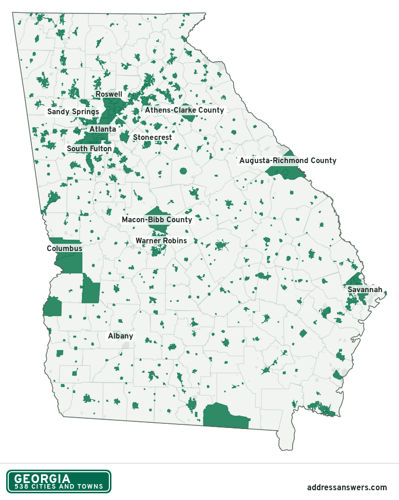
Georgia city limits map image
The map above as a picture: every Georgia city and town in green, with county lines. Boundaries from the Census Bureau, as of January 1, 2025.
You’re welcome to use it in a document or on your own site, with a link back to this page.
Download the map (PNG, 777 × 972)Questions about Georgia city limits
How many cities and towns are in Georgia?
Georgia has 538 incorporated places: 436 cities and 102 towns, by the Census Bureau’s boundary files for 2025.
What is the largest city in Georgia?
By population, Atlanta, with about 505,268 residents (2020–2024 American Community Survey 5-year estimates). By land area the largest is Echols County, at 420.4 square miles (Atlanta: 135.3).
What is the smallest city in Georgia?
By the Census Bureau’s estimate, Edge Hill, with 14 residents. Estimates for places this small have a wide margin of error, so treat it as a rough count.
How much of Georgia is unincorporated?
91% of its land and 6 million of its residents (55%) are outside every city or town. There, local government is the county. The state also has 138 named unincorporated communities; the largest is Evans.
Is Evans, GA a city?
No. Evans is a census-designated place: a community the Census Bureau maps for statistics, with no city government of its own. About 36,998 people live there, in unincorporated Columbia County. An address there is outside city limits, even if its mailing address says otherwise.
Is Martinez, GA a city?
No. Martinez is a census-designated place: a community the Census Bureau maps for statistics, with no city government of its own. About 33,750 people live there, in unincorporated Columbia County. An address there is outside city limits, even if its mailing address says otherwise.
Which cities and towns in Georgia are in more than one county?
47 of the 538 cross a county line, by at least 1% of their land. The largest: Atlanta (Fulton and DeKalb), Warner Robins (Houston and Peach), and Perry (Houston and Peach). Check an address to see which county it’s in.
Which county in Georgia has the most cities and towns?
Gwinnett County, with 17 at least partly inside it. Every county in Georgia has at least one.
Bordering states
More answers for a Georgia address
Each tool checks the same address and puts its own answer first.
- County Census Your county, plus the township or town where those exist. Find your county
- School district Census The public school district that covers the address. Find your school district
- Flood zone FEMA The FEMA zone in plain English, and whether lenders require flood insurance. Check flood zone
- USDA home loans USDA Whether the property is in an area eligible for a USDA Rural Development loan. Check USDA eligibility
- Voting districts Census Your congressional district and your state senate and state house districts. Included in every check
Places, boundaries, land area and counties: US Census Bureau 2025 cartographic boundary files (boundaries as of January 1, 2025). A place is listed in each county that holds at least 1% of its land. Population: 2020–2024 American Community Survey 5-year estimates. Data updated October 24, 2026; page updated October 25, 2026. Boundaries change through annexation; your city or county has the official map.