Arkansas city limits map
Arkansas has 501 incorporated places: 315 cities and 186 towns. They cover 4.9% of the state’s land and are home to 68% of its residents. Everyone else lives outside city limits, where local government is the county. Enter an address to see which side of a city line it’s on.
Result for
The map couldn’t load. The answers don’t depend on it.
The boundary couldn’t load. The answer doesn’t depend on it.
Census Geocoder match
More about this address
Sources and limits
- Census
- US Census Bureau Geocoder, current boundaries
- FEMA
- National Flood Hazard Layer, effective flood maps
- USDA
- Rural Development property eligibility
- Map
- Boundaries from Census TIGERweb, flood zones drawn by FEMA, eligible areas from USDA, base map © OpenStreetMap contributors
Census boundaries are updated once a year, so a recent annexation may not show yet. Informational only, not an official determination. Verify with your city or county.
Arkansas at a glance
- Incorporated places
- 501
- 315 cities and 186 towns
- Residents in city limits
- 68%
- 2,066,405 of 3,049,391
- Land in city limits
- 4.9%
- 2,533 of 51,992 sq mi
- Counties
- 75
- Every one has at least one
- Unincorporated communities
- 125
- Largest: Hot Springs Village (16,327)
- Largest city
- Little Rock
- 203,436 residents
How local government works in Arkansas
The Census Bureau maps 1,079 townships in Arkansas. They are geographic divisions with no government of their own. A township isn’t a city, so an address in one is outside city limits unless it’s also inside a city.
City limits map for Little Rock
Its own page has the boundary in detail, the communities around it and its school districts.
All 501 cities and towns in Arkansas
Every incorporated place, largest first, with the counties it’s in and its size. An address inside one of these is inside city limits; anywhere else in the state is unincorporated.
| Name | Type | County | Population | Land (sq mi) |
|---|---|---|---|---|
| Little Rock | City | Pulaski | 203,436 | 121.2 |
| Fayetteville | City | Washington | 99,319 | 54.8 |
| Fort Smith | City | Sebastian | 89,805 | 64.2 |
| Springdale | City | Washington, Benton | 88,160 | 49.8 |
| Jonesboro | City | Craighead | 80,137 | 80.2 |
| Rogers | City | Benton | 72,981 | 38.4 |
| Conway | City | Faulkner | 67,642 | 46.7 |
| North Little Rock | City | Pulaski | 64,538 | 53.0 |
| Bentonville | City | Benton | 58,249 | 35.5 |
| Pine Bluff | City | Jefferson | 39,743 | 44.2 |
| Hot Springs | City | Garland | 37,920 | 37.6 |
| Benton | City | Saline | 36,595 | 23.5 |
| Sherwood | City | Pulaski | 33,070 | 20.8 |
| Bella Vista | City | Benton | 31,697 | 45.3 |
| Paragould | City | Greene | 30,215 | 31.8 |
| Jacksonville | City | Pulaski | 29,221 | 28.7 |
| Texarkana | City | Miller | 29,177 | 42.0 |
| Russellville | City | Pope | 29,162 | 29.1 |
| Cabot | City | Lonoke | 26,960 | 20.8 |
| West Memphis | City | Crittenden | 23,929 | 29.8 |
| Van Buren | City | Crawford | 23,763 | 15.5 |
| Searcy | City | White | 23,340 | 18.3 |
| Centerton | City | Benton | 21,920 | 14.3 |
| Bryant | City | Saline | 21,504 | 20.5 |
| Maumelle | City | Pulaski | 19,373 | 12.4 |
| Siloam Springs | City | Benton | 18,699 | 12.3 |
| El Dorado | City | Union | 17,115 | 16.2 |
| Marion | City | Crittenden | 13,623 | 20.3 |
| Harrison | City | Boone | 13,350 | 11.2 |
| Mountain Home | City | Baxter | 13,108 | 12.1 |
| Blytheville | City | Mississippi | 12,790 | 20.7 |
| Forrest City | City | St. Francis | 12,646 | 20.2 |
| Batesville | City | Independence | 11,445 | 11.6 |
| Malvern | City | Hot Spring | 10,953 | 9.70 |
| Magnolia | City | Columbia | 10,894 | 13.2 |
| Lowell | City | Benton | 10,849 | 9.78 |
| Camden | City | Ouachita | 10,307 | 16.5 |
| Arkadelphia | City | Clark | 10,099 | 7.73 |
| Greenwood | City | Sebastian | 9,616 | 11.5 |
| Clarksville | City | Johnson | 9,526 | 18.2 |
| Farmington | City | Washington | 9,094 | 9.83 |
| Helena-West Helena | City | Phillips | 8,935 | 13.1 |
| Beebe | City | White | 8,707 | 10.2 |
| Hope | City | Hempstead | 8,671 | 10.7 |
| Monticello | City | Drew | 8,257 | 10.7 |
| Wynne | City | Cross | 8,120 | 8.99 |
| Pea Ridge | City | Benton | 8,108 | 8.38 |
| Newport | City | Jackson | 8,024 | 13.6 |
| Stuttgart | City | Arkansas | 7,903 | 7.41 |
| Prairie Grove | City | Washington | 7,798 | 9.33 |
| Pocahontas | City | Randolph | 7,538 | 7.69 |
| Trumann | City | Poinsett | 7,410 | 5.85 |
| Heber Springs | City | Cleburne | 7,161 | 9.09 |
| Morrilton | City | Conway | 7,080 | 8.86 |
| Osceola | City | Mississippi | 6,688 | 11.5 |
| Ward | City | Lonoke | 6,573 | 4.78 |
| Tontitown | City | Washington | 6,425 | 17.9 |
| De Queen | City | Sevier | 6,058 | 6.06 |
| Greenbrier | City | Faulkner | 6,018 | 7.95 |
| Cave Springs | City | Benton | 6,008 | 8.55 |
| Alma | City | Crawford | 5,906 | 5.73 |
| Berryville | City | Carroll | 5,707 | 6.60 |
| Mena | City | Polk | 5,582 | 6.94 |
| White Hall | City | Jefferson | 5,512 | 7.06 |
| Walnut Ridge | City | Lawrence | 5,434 | 16.7 |
| Warren | City | Bradley | 5,353 | 7.03 |
| Sheridan | City | Grant | 5,165 | 12.4 |
| Cherokee Village | City | Sharp, Fulton | 5,046 | 20.4 |
| Barling | City | Sebastian | 5,007 | 10.3 |
| Shannon Hills | City | Saline | 4,641 | 2.64 |
| Crossett | City | Ashley | 4,639 | 7.16 |
| Dardanelle | City | Yell | 4,511 | 3.64 |
| Vilonia | City | Faulkner | 4,498 | 8.15 |
| Brookland | City | Craighead | 4,377 | 8.10 |
| Lonoke | City | Lonoke | 4,267 | 4.81 |
| Southside | City | Independence | 4,246 | 9.86 |
| Gentry | City | Benton | 4,240 | 5.98 |
| Ashdown | City | Little River | 4,164 | 7.14 |
| Haskell | City | Saline | 4,100 | 4.89 |
| Nashville | City | Howard | 4,063 | 5.47 |
| Austin | City | Lonoke | 3,915 | 3.10 |
| Elkins | City | Washington | 3,808 | 3.87 |
| Booneville | City | Logan | 3,798 | 3.94 |
| Dumas | City | Desha | 3,768 | 2.91 |
| Gravette | City | Benton | 3,714 | 15.3 |
| Manila | City | Mississippi | 3,691 | 3.98 |
| McGehee | City | Desha | 3,666 | 6.71 |
| Johnson | City | Washington | 3,656 | 3.61 |
| Alexander | City | Saline, Pulaski | 3,587 | 2.26 |
| Piggott | City | Clay | 3,555 | 5.40 |
| Ozark | City | Franklin | 3,551 | 7.94 |
| Marianna | City | Lee | 3,417 | 3.61 |
| Waldron | City | Scott | 3,344 | 5.63 |
| Paris | City | Logan | 3,284 | 5.51 |
| Fordyce | City | Dallas | 3,268 | 6.73 |
| Pottsville | City | Pope | 3,229 | 13.5 |
| Huntsville | City | Madison | 3,202 | 5.40 |
| Corning | City | Clay | 3,134 | 3.67 |
| Green Forest | City | Carroll | 3,112 | 2.46 |
| West Fork | City | Washington | 3,095 | 3.74 |
| Elm Springs | City | Washington, Benton | 3,069 | 5.95 |
| Little Flock | City | Benton | 3,056 | 7.51 |
| Prescott | City | Nevada | 3,032 | 6.42 |
| DeWitt | City | Arkansas | 2,933 | 2.99 |
| Mountain View | City | Stone | 2,913 | 7.30 |
| Hamburg | City | Ashley | 2,886 | 3.44 |
| Atkins | City | Pope | 2,877 | 6.13 |
| Mayflower | City | Faulkner | 2,861 | 4.50 |
| Lincoln | City | Washington | 2,794 | 2.87 |
| Gosnell | City | Mississippi | 2,778 | 1.61 |
| Bono | City | Craighead | 2,657 | 2.66 |
| Charleston | City | Franklin | 2,646 | 3.83 |
| Hoxie | City | Lawrence | 2,618 | 6.67 |
| Brinkley | City | Monroe | 2,596 | 5.71 |
| Horseshoe Bend | City | Izard, Fulton +1 | 2,555 | 13.4 |
| Lake City | City | Craighead | 2,531 | 3.15 |
| Bald Knob | City | White | 2,518 | 4.95 |
| Fairfield Bay | City | Van Buren, Cleburne | 2,515 | 15.1 |
| Clinton | City | Van Buren | 2,509 | 13.1 |
| Lavaca | City | Sebastian | 2,489 | 2.22 |
| Holiday Island | City | Carroll | 2,480 | 7.26 |
| Eureka Springs | City | Carroll | 2,433 | 6.76 |
| Smackover | City | Union | 2,419 | 4.35 |
| Star City | City | Lincoln | 2,405 | 4.80 |
| Bay | City | Craighead | 2,333 | 3.09 |
| Dermott | City | Chicot | 2,330 | 3.42 |
| Goshen | Town | Washington | 2,298 | 11.3 |
| England | City | Lonoke | 2,294 | 1.89 |
| Danville | City | Yell | 2,289 | 4.28 |
| Melbourne | City | Izard | 2,263 | 6.95 |
| Marked Tree | City | Poinsett | 2,249 | 5.77 |
| Carlisle | City | Lonoke | 2,227 | 4.84 |
| Harrisburg | City | Poinsett | 2,216 | 2.40 |
| Highfill | Town | Benton | 2,191 | 18.8 |
| Lake Village | City | Chicot | 2,144 | 2.39 |
| Cave City | City | Sharp, Independence | 2,090 | 2.45 |
| Judsonia | City | White | 2,052 | 2.89 |
| Lepanto | City | Poinsett | 2,025 | 1.56 |
| Kensett | City | White | 1,937 | 1.87 |
| Hazen | City | Prairie | 1,874 | 3.52 |
| Eudora | City | Chicot | 1,868 | 3.09 |
| Augusta | City | Woodruff | 1,859 | 2.07 |
| Leachville | City | Mississippi | 1,852 | 4.40 |
| Gassville | City | Baxter | 1,850 | 3.43 |
| McCrory | City | Woodruff | 1,850 | 2.37 |
| Glenwood | City | Pike, Montgomery | 1,841 | 8.91 |
| Clarendon | City | Monroe | 1,820 | 1.75 |
| Murfreesboro | City | Pike | 1,819 | 3.68 |
| Dover | City | Pope | 1,795 | 2.83 |
| Lamar | City | Johnson | 1,783 | 4.62 |
| Calico Rock | City | Izard | 1,771 | 4.76 |
| Cedarville | City | Crawford | 1,760 | 8.41 |
| Rector | City | Clay | 1,750 | 1.36 |
| Redfield | City | Jefferson | 1,734 | 3.09 |
| Bull Shoals | City | Marion | 1,678 | 4.90 |
| Mulberry | City | Crawford | 1,646 | 7.83 |
| Newark | City | Independence | 1,637 | 1.64 |
| Gurdon | City | Clark | 1,625 | 2.43 |
| Salem | City | Fulton | 1,620 | 2.41 |
| Des Arc | City | Prairie | 1,591 | 2.10 |
| Decatur | City | Benton | 1,567 | 4.81 |
| Earle | City | Crittenden | 1,520 | 3.25 |
| Wrightsville | City | Pulaski | 1,484 | 2.13 |
| Tuckerman | City | Jackson | 1,442 | 2.68 |
| Stamps | City | Lafayette | 1,404 | 3.05 |
| Perryville | City | Perry | 1,390 | 4.27 |
| Mount Ida | City | Montgomery | 1,376 | 1.57 |
| Mineral Springs | City | Howard | 1,358 | 2.13 |
| Highland | City | Sharp | 1,354 | 8.74 |
| Diaz | City | Jackson | 1,337 | 5.92 |
| Flippin | City | Marion | 1,334 | 1.88 |
| Greenland | City | Washington | 1,274 | 6.56 |
| Monette | City | Craighead | 1,251 | 5.66 |
| Marmaduke | City | Greene | 1,240 | 1.40 |
| Mammoth Spring | City | Fulton | 1,226 | 1.29 |
| Yellville | City | Marion | 1,223 | 2.48 |
| Ash Flat | City | Sharp, Fulton | 1,217 | 6.37 |
| London | City | Pope | 1,217 | 3.17 |
| Mansfield | City | Scott, Sebastian | 1,204 | 2.31 |
| Horatio | City | Sevier | 1,196 | 1.78 |
| Marshall | City | Searcy | 1,196 | 4.08 |
| Oak Grove Heights | Town | Greene | 1,164 | 2.99 |
| Marvell | City | Phillips | 1,160 | 1.44 |
| Waldo | City | Columbia | 1,144 | 2.19 |
| Plumerville | City | Conway | 1,128 | 1.03 |
| Hackett | City | Sebastian | 1,118 | 1.44 |
| Oppelo | City | Conway | 1,118 | 2.47 |
| Swifton | City | Jackson | 1,101 | 0.54 |
| Stephens | City | Ouachita | 1,099 | 2.76 |
| Caraway | City | Craighead | 1,087 | 2.30 |
| Kibler | City | Crawford | 1,085 | 5.00 |
| Cotter | City | Baxter | 1,063 | 2.45 |
| Higginson | Town | White | 1,055 | 1.27 |
| Dyer | City | Crawford | 1,049 | 2.94 |
| Foreman | City | Little River | 1,044 | 1.98 |
| Hampton | City | Calhoun | 1,037 | 3.28 |
| East Camden | Town | Ouachita | 1,026 | 0.76 |
| Wilson | City | Mississippi | 1,023 | 1.05 |
| Wooster | Town | Faulkner | 1,023 | 2.85 |
| Rison | City | Cleveland | 1,019 | 3.28 |
| Sulphur Rock | Town | Independence | 1,014 | 1.26 |
| Norphlet | City | Union | 1,003 | 2.03 |
| Magazine | City | Logan | 986 | 1.82 |
| Ola | City | Yell | 914 | 1.70 |
| Lewisville | City | Lafayette | 903 | 2.15 |
| Coal Hill | City | Johnson | 892 | 2.80 |
| Hardy | City | Sharp, Fulton | 890 | 5.18 |
| Hughes | City | St. Francis | 886 | 2.26 |
| Lockesburg | City | Sevier | 873 | 3.48 |
| Fouke | City | Miller | 859 | 1.36 |
| Black Rock | City | Lawrence | 853 | 3.29 |
| Lakeview | City | Baxter | 851 | 1.04 |
| Bauxite | Town | Saline | 846 | 3.43 |
| Altus | City | Franklin | 827 | 2.08 |
| Bearden | City | Ouachita | 826 | 1.61 |
| Oxford | City | Izard | 820 | 6.54 |
| Quitman | City | Cleburne, Faulkner | 805 | 1.89 |
| Palestine | City | St. Francis | 800 | 3.40 |
| Rockport | City | Hot Spring | 800 | 4.10 |
| Avoca | Town | Benton | 799 | 1.93 |
| Cammack Village | City | Pulaski | 797 | 0.28 |
| Greers Ferry | City | Cleburne | 778 | 7.22 |
| Caddo Valley | Town | Clark | 775 | 3.11 |
| Keiser | City | Mississippi | 774 | 0.43 |
| Luxora | City | Mississippi | 741 | 0.85 |
| Amity | City | Clark | 740 | 3.21 |
| Dierks | City | Howard | 728 | 1.92 |
| Midway | Town | Hot Spring | 728 | 3.52 |
| Guy | City | Faulkner | 720 | 7.13 |
| Bonanza | City | Sebastian | 711 | 2.79 |
| Summit | City | Marion | 706 | 1.21 |
| Parkin | City | Cross | 694 | 2.56 |
| Wickes | Town | Polk | 694 | 2.32 |
| Grannis | City | Polk | 691 | 7.93 |
| Norfork | City | Baxter | 690 | 2.23 |
| Weiner | City | Poinsett | 680 | 1.36 |
| Hartman | City | Johnson | 678 | 1.58 |
| Diamond City | City | Boone | 672 | 2.82 |
| Knoxville | Town | Johnson | 663 | 3.18 |
| Gould | City | Lincoln | 661 | 1.55 |
| Rose Bud | Town | White | 656 | 6.04 |
| Central City | Town | Sebastian | 627 | 2.22 |
| Tyronza | City | Poinsett | 627 | 1.56 |
| Holland | City | Faulkner | 623 | 6.73 |
| McRae | City | White | 623 | 0.67 |
| Imboden | Town | Lawrence | 621 | 1.27 |
| Tull | Town | Grant | 596 | 4.03 |
| Taylor | City | Columbia | 593 | 0.99 |
| Mountainburg | City | Crawford | 566 | 1.47 |
| Junction City | City | Union | 564 | 1.14 |
| Mountain Pine | City | Garland | 555 | 1.66 |
| De Valls Bluff | City | Prairie | 553 | 1.09 |
| Traskwood | City | Saline | 552 | 5.63 |
| Plainview | City | Yell | 550 | 1.46 |
| Fountain Lake | Town | Garland | 548 | 4.37 |
| Hatfield | Town | Polk | 544 | 1.33 |
| Cherry Valley | City | Cross | 543 | 3.99 |
| Bergman | Town | Boone | 542 | 1.30 |
| Evening Shade | City | Sharp | 534 | 1.67 |
| Bradley | City | Lafayette | 528 | 0.91 |
| Wilmar | City | Drew | 523 | 1.53 |
| Bradford | City | White | 522 | 0.87 |
| Altheimer | City | Jefferson | 517 | 2.05 |
| Belleville | City | Yell | 517 | 1.87 |
| Pangburn | City | White | 515 | 0.54 |
| Salesville | City | Baxter | 515 | 4.51 |
| Alpena | Town | Carroll, Boone | 510 | 1.33 |
| Colt | City | St. Francis | 510 | 1.26 |
| Garfield | City | Benton | 508 | 3.11 |
| Sulphur Springs | City | Benton | 499 | 1.01 |
| Hartford | City | Sebastian | 496 | 1.80 |
| Turrell | City | Crittenden | 496 | 5.35 |
| Holly Grove | City | Monroe | 495 | 1.00 |
| Cushman | City | Independence | 488 | 4.08 |
| Elaine | City | Phillips | 487 | 0.51 |
| Lafe | Town | Greene | 478 | 2.03 |
| Madison | City | St. Francis | 476 | 2.48 |
| Clarkedale | City | Crittenden | 468 | 11.4 |
| Huntington | City | Sebastian | 468 | 0.67 |
| Cove | Town | Polk | 462 | 1.60 |
| Arkansas City | City | Desha | 456 | 0.49 |
| Joiner | City | Mississippi | 454 | 0.62 |
| Jasper | City | Newton | 453 | 0.95 |
| Portia | Town | Lawrence | 453 | 1.29 |
| Cotton Plant | City | Woodruff | 444 | 1.04 |
| Leslie | City | Searcy | 444 | 0.76 |
| Portland | City | Ashley | 444 | 1.07 |
| Caldwell | Town | St. Francis | 441 | 3.19 |
| Poyen | Town | Grant | 441 | 0.31 |
| Western Grove | Town | Newton | 438 | 1.08 |
| Emmet | City | Nevada, Hempstead | 435 | 1.44 |
| Strong | City | Union | 434 | 1.60 |
| Enola | Town | Faulkner | 432 | 2.71 |
| Grubbs | City | Jackson | 431 | 0.57 |
| Sparkman | City | Dallas | 430 | 1.29 |
| Bellefonte | Town | Boone | 428 | 0.62 |
| Biggers | Town | Randolph | 428 | 1.00 |
| Prattsville | Town | Grant | 428 | 1.62 |
| Crawfordsville | Town | Crittenden | 424 | 0.56 |
| McNeil | City | Columbia | 419 | 1.27 |
| Horseshoe Lake | Town | Crittenden | 414 | 0.15 |
| Leola | Town | Grant | 414 | 0.85 |
| Menifee | Town | Conway | 409 | 2.27 |
| Wilmot | City | Ashley | 408 | 1.77 |
| Kingsland | City | Cleveland | 406 | 1.12 |
| Subiaco | Town | Logan | 405 | 1.89 |
| Huttig | City | Union | 401 | 2.98 |
| Bigelow | Town | Perry | 393 | 0.94 |
| Rosston | Town | Nevada | 391 | 4.42 |
| Ravenden | Town | Lawrence | 390 | 2.11 |
| Viola | Town | Fulton | 384 | 1.57 |
| Gillett | City | Arkansas | 378 | 1.00 |
| Donaldson | Town | Hot Spring | 377 | 0.59 |
| Pleasant Plains | Town | Independence | 376 | 1.03 |
| Wheatley | City | St. Francis | 374 | 3.07 |
| Patterson | City | Woodruff | 364 | 1.13 |
| Wabbaseka | Town | Jefferson | 360 | 0.34 |
| Lake View | City | Phillips | 357 | 5.00 |
| Perry | Town | Perry | 356 | 0.70 |
| Calion | City | Union | 355 | 1.07 |
| Damascus | Town | Van Buren, Faulkner | 348 | 1.86 |
| Oden | Town | Montgomery | 347 | 0.81 |
| Mount Pleasant | Town | Izard | 345 | 3.50 |
| Havana | City | Yell | 343 | 0.60 |
| Norman | Town | Montgomery | 339 | 1.12 |
| Hector | Town | Pope | 334 | 2.29 |
| Ben Lomond | Town | Sevier | 330 | 3.92 |
| Hermitage | City | Bradley | 327 | 1.07 |
| Harrell | Town | Calhoun | 323 | 0.55 |
| Keo | Town | Lonoke | 322 | 4.92 |
| Lead Hill | Town | Boone | 320 | 0.58 |
| Mitchellville | City | Desha | 320 | 0.12 |
| Branch | City | Franklin | 317 | 3.12 |
| Etowah | Town | Mississippi | 316 | 5.94 |
| Delight | City | Pike | 312 | 0.55 |
| Campbell Station | City | Jackson | 311 | 1.70 |
| Reyno | City | Randolph | 310 | 1.01 |
| Edmondson | Town | Crittenden | 308 | 2.99 |
| Pineville | Town | Izard | 306 | 1.81 |
| Chidester | City | Ouachita | 305 | 5.31 |
| Wilton | City | Little River | 305 | 1.28 |
| Maynard | Town | Randolph | 303 | 1.26 |
| Houston | Town | Perry | 299 | 1.01 |
| Lynn | Town | Lawrence | 299 | 2.31 |
| Gilmore | City | Crittenden | 293 | 13.5 |
| Gateway | Town | Benton | 292 | 6.56 |
| Thornton | City | Calhoun | 292 | 1.92 |
| Winslow | City | Washington | 291 | 1.82 |
| Dyess | Town | Mississippi | 289 | 0.96 |
| Okolona | Town | Clark | 287 | 0.79 |
| Oak Grove | Town | Carroll | 285 | 2.82 |
| Strawberry | Town | Lawrence | 285 | 2.34 |
| Buckner | City | Lafayette | 284 | 1.18 |
| Franklin | Town | Izard | 283 | 2.13 |
| Cash | Town | Craighead | 278 | 0.37 |
| Shirley | Town | Van Buren | 269 | 2.41 |
| Moro | Town | Lee | 264 | 0.96 |
| Midland | Town | Sebastian | 262 | 0.35 |
| Greenway | City | Clay | 261 | 0.26 |
| Hickory Ridge | City | Cross | 259 | 0.65 |
| Oil Trough | Town | Independence | 259 | 0.23 |
| Twin Groves | Town | Faulkner | 258 | 4.60 |
| Briarcliff | City | Baxter | 257 | 2.25 |
| Perrytown | Town | Hempstead | 251 | 1.39 |
| St. Charles | Town | Arkansas | 250 | 0.89 |
| Griffithville | Town | White | 249 | 0.55 |
| Willisville | Town | Nevada | 246 | 1.60 |
| Denning | Town | Franklin | 245 | 1.08 |
| Emerson | Town | Columbia | 239 | 0.99 |
| Magness | Town | Independence | 238 | 0.61 |
| Widener | Town | St. Francis | 238 | 0.54 |
| Burdette | Town | Mississippi | 233 | 0.74 |
| Bluff City | Town | Nevada | 222 | 2.32 |
| Humphrey | City | Arkansas, Jefferson | 220 | 1.31 |
| Scranton | City | Logan | 220 | 0.51 |
| Russell | Town | White | 218 | 0.21 |
| Watson | City | Desha | 214 | 0.20 |
| Letona | Town | White | 213 | 0.39 |
| Lonsdale | Town | Garland | 211 | 0.40 |
| Casa | Town | Perry | 206 | 1.12 |
| Fifty-Six | City | Stone | 205 | 2.07 |
| Tollette | Town | Howard | 204 | 0.96 |
| Vandervoort | Town | Polk | 202 | 0.29 |
| Pindall | Town | Searcy | 198 | 2.87 |
| O'Kean | Town | Randolph | 196 | 1.02 |
| Caulksville | Town | Logan | 195 | 1.35 |
| Fulton | Town | Hempstead | 189 | 0.18 |
| Garland | Town | Miller | 188 | 0.88 |
| Carthage | City | Dallas | 185 | 0.99 |
| Higden | Town | Cleburne | 182 | 0.48 |
| Mount Vernon | Town | Faulkner | 182 | 1.01 |
| Black Oak | Town | Craighead | 179 | 0.45 |
| Rudy | Town | Crawford | 178 | 1.63 |
| Bodcaw | Town | Nevada | 177 | 3.00 |
| St. Francis | City | Clay | 177 | 0.35 |
| Dell | Town | Mississippi | 176 | 0.92 |
| Garner | Town | White | 175 | 0.79 |
| Sidney | Town | Sharp | 175 | 2.09 |
| Omaha | Town | Boone | 174 | 0.39 |
| Ulm | Town | Prairie | 174 | 0.26 |
| Powhatan | Town | Lawrence | 173 | 0.55 |
| Montrose | City | Ashley | 170 | 0.38 |
| Friendship | Town | Hot Spring | 168 | 0.71 |
| Grady | City | Lincoln | 168 | 2.95 |
| Blevins | City | Hempstead | 167 | 0.99 |
| Fisher | City | Poinsett | 167 | 0.30 |
| Sedgwick | Town | Lawrence | 165 | 0.52 |
| Ravenden Springs | Town | Randolph | 164 | 1.16 |
| Antoine | Town | Pike | 159 | 0.51 |
| Knobel | City | Clay | 158 | 0.42 |
| Reed | Town | Desha | 156 | 0.20 |
| Sunset | Town | Crittenden | 153 | 0.26 |
| Gillham | Town | Sevier | 147 | 0.87 |
| Almyra | Town | Arkansas | 146 | 0.39 |
| Hindsville | Town | Madison | 146 | 0.37 |
| Pollard | City | Clay | 143 | 0.30 |
| Perla | Town | Hot Spring | 141 | 0.96 |
| Ogden | City | Little River | 140 | 0.38 |
| Aubrey | Town | Lee | 139 | 0.33 |
| Blue Mountain | Town | Logan | 139 | 1.07 |
| Alicia | Town | Lawrence | 138 | 0.43 |
| Daisy | Town | Pike | 138 | 1.14 |
| Lexa | Town | Phillips | 138 | 0.41 |
| St. Joe | Town | Searcy | 136 | 1.24 |
| St. Paul | Town | Madison | 136 | 0.45 |
| Weldon | Town | Jackson | 136 | 0.24 |
| Fredonia (Biscoe) | Town | Prairie | 135 | 0.96 |
| Pyatt | Town | Marion | 135 | 1.26 |
| Concord | Town | Cleburne | 130 | 3.08 |
| Roe | Town | Monroe | 129 | 0.18 |
| Banks | Town | Bradley | 126 | 0.38 |
| Humnoke | City | Lonoke | 122 | 0.31 |
| Winchester | Town | Drew | 122 | 0.50 |
| Beaver | Town | Carroll | 121 | 0.31 |
| Valley Springs | Town | Boone | 121 | 0.51 |
| Moorefield | Town | Independence | 120 | 1.13 |
| Jericho | Town | Crittenden | 119 | 0.31 |
| Louann | Town | Ouachita | 119 | 0.24 |
| Tillar | City | Drew, Desha | 119 | 0.78 |
| Bassett | Town | Mississippi | 118 | 0.24 |
| McDougal | Town | Clay | 116 | 0.37 |
| Jacksonport | Town | Jackson | 115 | 0.38 |
| Rondo | Town | Lee | 111 | 1.01 |
| Springtown | Town | Benton | 109 | 0.54 |
| Allport | Town | Lonoke | 102 | 0.21 |
| Black Springs | Town | Montgomery | 101 | 0.45 |
| Hunter | Town | Woodruff | 100 | 0.62 |
| Ratcliff | City | Logan | 97 | 1.81 |
| Washington | City | Hempstead | 93 | 1.01 |
| West Point | Town | White | 93 | 0.43 |
| Winthrop | City | Little River | 93 | 1.04 |
| Success | Town | Clay | 92 | 0.22 |
| Minturn | Town | Lawrence | 91 | 0.57 |
| Morrison Bluff | Town | Logan | 91 | 1.34 |
| Smithville | Town | Lawrence | 88 | 0.67 |
| Cale | Town | Nevada | 86 | 0.97 |
| Jennette | Town | Crittenden | 86 | 2.27 |
| Peach Orchard | City | Clay | 86 | 1.03 |
| Tupelo | Town | Jackson | 86 | 0.28 |
| Delaplaine | Town | Greene | 85 | 1.11 |
| Fountain Hill | Town | Ashley | 81 | 0.57 |
| Everton | Town | Boone | 79 | 0.47 |
| Chester | Town | Crawford | 76 | 0.51 |
| Haynes | Town | Lee | 75 | 0.35 |
| McNab | Town | Hempstead | 73 | 0.34 |
| Big Flat | Town | Baxter | 71 | 1.14 |
| Williford | Town | Sharp | 71 | 0.35 |
| South Lead Hill | Town | Boone | 69 | 0.16 |
| Datto | Town | Clay | 67 | 0.62 |
| Parkdale | City | Ashley | 67 | 1.02 |
| Waldenburg | Town | Poinsett | 63 | 0.14 |
| Adona | City | Perry | 62 | 0.95 |
| Anthonyville | Town | Crittenden | 62 | 0.08 |
| Guion | Town | Izard | 61 | 0.56 |
| Coy | Town | Lonoke | 60 | 0.67 |
| Egypt | Town | Craighead | 57 | 0.34 |
| Gum Springs | Town | Clark | 55 | 0.39 |
| LaGrange | Town | Lee | 53 | 0.15 |
| Whelen Springs | Town | Clark | 52 | 0.23 |
| Marie | Town | Mississippi | 50 | 0.15 |
| McCaskill | Town | Hempstead | 46 | 0.74 |
| Zinc | Town | Boone | 45 | 0.75 |
| Beedeville | Town | Jackson | 44 | 1.14 |
| Ozan | Town | Hempstead | 43 | 0.33 |
| Sherrill | Town | Jefferson | 41 | 0.13 |
| Felsenthal | Town | Union | 40 | 1.48 |
| Georgetown | Town | White | 40 | 0.29 |
| Corinth | Town | Yell | 38 | 3.09 |
| Patmos | Town | Hempstead | 38 | 0.11 |
| Birdsong | Town | Mississippi | 35 | 0.20 |
| Oakhaven | Town | Hempstead | 34 | 0.05 |
| Blue Eye | Town | Carroll | 33 | 0.07 |
| Amagon | Town | Jackson | 31 | 0.11 |
| Fargo | Town | Monroe | 30 | 0.46 |
| Nimmons | Town | Clay | 22 | 0.25 |
| Fourche | Town | Perry | 20 | 0.20 |
| Tinsman | Town | Calhoun | 18 | 0.53 |
| Wiederkehr Village | City | Franklin | 18 | 4.24 |
| Gilbert | Town | Searcy | 16 | 0.37 |
| Victoria | Town | Mississippi | 0 | 0.32 |
| Diamondhead | City | Garland | – | 2.36 |
Showing 1–50 of 501
Unincorporated communities in Arkansas
Census-designated places: named communities the Census Bureau maps for statistics, with no city government of their own. An address in one is outside city limits, even when its mailing address names a city. Arkansas has 125.
| Community | County | Population | Land (sq mi) |
|---|---|---|---|
| Hot Springs Village | Garland | 16,327 | 57.6 |
| East End | Saline | 6,912 | 20.1 |
| Piney | Garland | 4,458 | 6.51 |
| Gibson | Pulaski | 4,167 | 4.75 |
| Rockwell | Garland | 3,986 | 3.27 |
| Landmark | Pulaski | 3,948 | 9.83 |
| Salem | Saline | 2,642 | 3.12 |
| North Crossett | Ashley | 2,556 | 10.4 |
| Prairie Creek | Benton | 2,493 | 4.37 |
| Lake Hamilton | Garland | 2,127 | 2.07 |
| Avilla | Saline | 1,833 | 6.33 |
| West Crossett | Ashley | 1,413 | 11.9 |
| Midway | Baxter | 1,279 | 5.76 |
| Roland | Pulaski | 1,147 | 8.07 |
| Genoa | Miller | 1,113 | 6.61 |
| McAlmont | Pulaski | 1,088 | 1.57 |
| Sweet Home | Pulaski | 939 | 3.89 |
| Sardis | Saline | 890 | 1.84 |
| Magnet Cove | Hot Spring | 889 | 2.11 |
| Floyd | White | 881 | 4.83 |
| Lacey | Drew | 746 | 1.59 |
| Tumbling Shoals | Cleburne | 689 | 10.1 |
| Natural Steps | Pulaski | 683 | 2.76 |
| Desha | Independence | 679 | 2.27 |
| Ozark Acres | Sharp | 670 | 6.97 |
| Woodson | Pulaski | 619 | 4.35 |
| Kirby | Pike | 579 | 14.5 |
| Sulphur Springs | Jefferson | 564 | 5.53 |
| New Blaine | Logan | 533 | 1.59 |
| Salado | Independence | 507 | 1.98 |
| El Paso | White | 470 | 4.13 |
| Springfield | Conway | 438 | 1.75 |
| Henderson | Baxter | 415 | 7.35 |
| Fox | Stone | 381 | 5.45 |
| Yarborough Landing | Little River | 380 | 2.17 |
| Cherokee City | Benton | 369 | 0.47 |
| Pearcy | Garland | 363 | 1.55 |
| Vanndale | Cross | 356 | 1.02 |
| Armorel | Mississippi | 345 | 1.39 |
| Dennard | Van Buren | 315 | 21.9 |
| Walcott | Greene | 315 | 1.24 |
| Drasco | Cleburne | 314 | 1.71 |
| Batavia | Boone | 307 | 1.39 |
| Lost Bridge Village | Benton | 303 | 3.23 |
| Appleton | Pope | 292 | 5.15 |
| Aplin | Perry | 287 | 2.24 |
| Cincinnati | Washington | 278 | 7.48 |
| Summers | Washington | 267 | 2.44 |
| College Station | Pulaski | 258 | 1.09 |
| Poplar Grove | Phillips | 255 | 1.36 |
| Wesley | Madison | 233 | 1.37 |
| Jones Mills | Hot Spring | 230 | 3.20 |
| Rye | Cleveland | 223 | 4.37 |
| Center Ridge | Conway | 211 | 9.47 |
| Centerville | Yell | 211 | 3.15 |
| Acorn | Polk | 203 | 3.97 |
| Woodlawn | Cleveland | 197 | 2.35 |
| Bee Branch | Van Buren | 196 | 3.56 |
| Floral | Independence | 194 | 0.74 |
| Ozone | Johnson | 194 | 0.84 |
| Wayton | Newton | 187 | 4.07 |
| Pleasant Grove | Stone | 186 | 2.82 |
| Morrow | Washington | 182 | 2.87 |
| New Edinburg | Cleveland | 182 | 3.20 |
| Wilburn | Cleburne | 173 | 0.99 |
| Uniontown | Crawford | 168 | 0.96 |
| Staves | Cleveland | 155 | 2.43 |
| Boles | Scott | 153 | 2.35 |
| Urbana | Union | 147 | 1.86 |
| Oakland | Marion | 146 | 1.19 |
| Rover | Yell | 142 | 3.48 |
| Payneway | Poinsett | 133 | 5.34 |
| Deer | Newton | 113 | 2.79 |
| Maysville | Benton | 110 | 2.35 |
| Alleene | Little River | 96 | 2.19 |
| Center Point | Howard | 96 | 1.70 |
| Oak Grove | Pope | 91 | 3.76 |
| Hagarville | Johnson | 89 | 4.14 |
| Newhope | Pike | 88 | 3.03 |
| Warm Springs | Randolph | 87 | 2.81 |
| Lawson | Union | 86 | 3.29 |
| Crystal Springs | Garland | 85 | 2.23 |
| Bethesda | Independence | 79 | 1.46 |
| Witts Springs | Searcy | 77 | 3.81 |
| Evansville | Washington | 75 | 1.44 |
| Dora | Crawford | 74 | 0.80 |
| Ponca | Newton | 73 | 0.61 |
| Tucker | Jefferson | 73 | 0.82 |
| Board Camp | Polk | 69 | 2.98 |
| Mount Judea | Newton | 61 | 3.29 |
| Collins | Drew | 60 | 1.63 |
| Jerusalem | Conway | 57 | 1.35 |
| Goodwin | St. Francis | 56 | 4.52 |
| Pencil Bluff | Montgomery | 51 | 0.53 |
| Ivan | Dallas | 50 | 3.83 |
| Jerome | Drew | 50 | 0.18 |
| Scott | Lonoke | 46 | 3.16 |
| Reader | Ouachita | 43 | 2.34 |
| Bismarck | Hot Spring | 41 | 1.46 |
| Hattieville | Conway | 41 | 2.45 |
| Rivervale | Poinsett | 32 | 0.37 |
| Bowman | Craighead | 30 | 1.56 |
| Caddo Gap | Montgomery | 27 | 0.40 |
| Hensley | Pulaski | 26 | 1.02 |
| Edgemont | Cleburne | 24 | 0.37 |
| Fair Oaks | Cross | 23 | 2.40 |
| Alix | Franklin | 20 | 0.48 |
| Kingston | Madison | 19 | 1.59 |
| Mount Holly | Union | 18 | 2.79 |
| Oark | Johnson | 18 | 0.38 |
| Saratoga | Hempstead | 18 | 2.58 |
| Gamaliel | Baxter | 15 | 0.55 |
| Monroe | Monroe | 11 | 0.73 |
| Halley | Desha | 10 | 1.14 |
| Princeton | Dallas | 3 | 0.67 |
| Alpine | Clark | 0 | 1.44 |
| Beirne | Clark | 0 | 0.34 |
| Buffalo City | Baxter | 0 | 0.15 |
| Canehill | Washington | 0 | 2.18 |
| Gregory | Woodruff | 0 | 4.59 |
| Indian Bay | Monroe | 0 | 0.38 |
| Mellwood | Phillips | 0 | 0.89 |
| Mount Olive | Izard | 0 | 0.54 |
| Oneida | Phillips | 0 | 1.21 |
| Violet Hill | Izard | 0 | 0.56 |
Showing 1–50 of 125
Counties in Arkansas
75 counties, with how many cities and towns have land in each and the largest whose main county it is.
| County | Cities | Largest | Population | Land (sq mi) |
|---|---|---|---|---|
| Pulaski County | 8 | Little Rock | 399,818 | 758.4 |
| Benton County | 20 | Rogers | 303,632 | 847.7 |
| Washington County | 13 | Fayetteville | 256,765 | 941.5 |
| Sebastian County | 11 | Fort Smith | 128,900 | 531.2 |
| Faulkner County | 12 | Conway | 127,717 | 647.2 |
| Saline County | 7 | Benton | 127,479 | 723.5 |
| Craighead County | 10 | Jonesboro | 113,249 | 707.2 |
| Garland County | 5 | Hot Springs | 100,035 | 677.6 |
| White County | 16 | Searcy | 77,838 | 1,034 |
| Lonoke County | 10 | Cabot | 75,272 | 771.7 |
| Jefferson County | 7 | Pine Bluff | 64,802 | 872.3 |
| Pope County | 6 | Russellville | 64,131 | 811.0 |
| Crawford County | 9 | Van Buren | 61,139 | 595.3 |
| Crittenden County | 13 | West Memphis | 47,266 | 611.8 |
| Greene County | 5 | Paragould | 46,432 | 577.3 |
| Baxter County | 8 | Mountain Home | 42,407 | 553.9 |
| Miller County | 3 | Texarkana | 42,360 | 624.0 |
| Mississippi County | 17 | Blytheville | 39,126 | 902.1 |
| Independence County | 10 | Batesville | 38,175 | 763.7 |
| Boone County | 11 | Harrison | 38,138 | 589.7 |
| Union County | 8 | El Dorado | 37,900 | 1,039 |
| Hot Spring County | 6 | Malvern | 33,180 | 614.9 |
| Carroll County | 8 | Berryville | 28,626 | 629.9 |
| Johnson County | 5 | Clarksville | 26,003 | 661.0 |
| Cleburne County | 6 | Heber Springs | 25,226 | 554.0 |
| Poinsett County | 8 | Trumann | 22,543 | 758.3 |
| St. Francis County | 8 | Forrest City | 22,400 | 634.8 |
| Columbia County | 5 | Magnolia | 22,349 | 766.1 |
| Ouachita County | 6 | Camden | 22,085 | 732.7 |
| Logan County | 9 | Booneville | 21,277 | 709.1 |
| Clark County | 7 | Arkadelphia | 21,125 | 866.0 |
| Conway County | 4 | Morrilton | 21,054 | 552.0 |
| Yell County | 7 | Dardanelle | 20,134 | 930.4 |
| Hempstead County | 11 | Hope | 19,508 | 727.2 |
| Polk County | 6 | Mena | 19,361 | 856.8 |
| Randolph County | 6 | Pocahontas | 18,838 | 651.9 |
| Ashley County | 7 | Crossett | 18,429 | 925.5 |
| Grant County | 5 | Sheridan | 18,242 | 631.9 |
| Sharp County | 9 | Cherokee Village | 17,773 | 604.6 |
| Madison County | 3 | Huntsville | 17,329 | 834.2 |
| Franklin County | 6 | Ozark | 17,326 | 609.0 |
| Marion County | 5 | Bull Shoals | 17,228 | 596.6 |
| Drew County | 4 | Monticello | 17,046 | 828.7 |
| Jackson County | 11 | Newport | 16,712 | 633.6 |
| Cross County | 4 | Wynne | 16,543 | 616.3 |
| Arkansas County | 6 | Stuttgart | 16,515 | 992.1 |
| Lawrence County | 13 | Walnut Ridge | 16,238 | 587.5 |
| Van Buren County | 4 | Fairfield Bay | 15,998 | 709.6 |
| Sevier County | 5 | De Queen | 15,712 | 563.6 |
| Phillips County | 5 | Helena-West Helena | 15,450 | 690.4 |
| Clay County | 12 | Piggott | 14,280 | 639.2 |
| Izard County | 8 | Horseshoe Bend | 14,009 | 580.2 |
| Lincoln County | 3 | Star City | 12,950 | 559.5 |
| Howard County | 4 | Nashville | 12,583 | 587.3 |
| Stone County | 2 | Mountain View | 12,568 | 606.4 |
| Fulton County | 7 | Salem | 12,302 | 618.0 |
| Little River County | 5 | Ashdown | 11,821 | 531.3 |
| Desha County | 7 | Dumas | 10,786 | 741.2 |
| Bradley County | 3 | Warren | 10,208 | 649.2 |
| Pike County | 5 | Glenwood | 10,115 | 600.3 |
| Perry County | 7 | Perryville | 10,101 | 551.3 |
| Scott County | 2 | Waldron | 9,816 | 892.8 |
| Chicot County | 3 | Dermott | 9,765 | 637.0 |
| Montgomery County | 5 | Mount Ida | 8,553 | 780.5 |
| Lee County | 6 | Marianna | 8,359 | 599.8 |
| Nevada County | 7 | Prescott | 8,159 | 617.8 |
| Prairie County | 5 | Hazen | 8,064 | 647.5 |
| Searcy County | 5 | Marshall | 7,859 | 665.9 |
| Cleveland County | 2 | Rison | 7,453 | 597.9 |
| Newton County | 2 | Jasper | 7,112 | 821.1 |
| Monroe County | 5 | Brinkley | 6,589 | 607.5 |
| Dallas County | 3 | Fordyce | 6,242 | 667.3 |
| Lafayette County | 4 | Stamps | 6,136 | 529.5 |
| Woodruff County | 5 | Augusta | 6,026 | 586.0 |
| Calhoun County | 4 | Hampton | 4,704 | 628.6 |
Showing 1–50 of 75
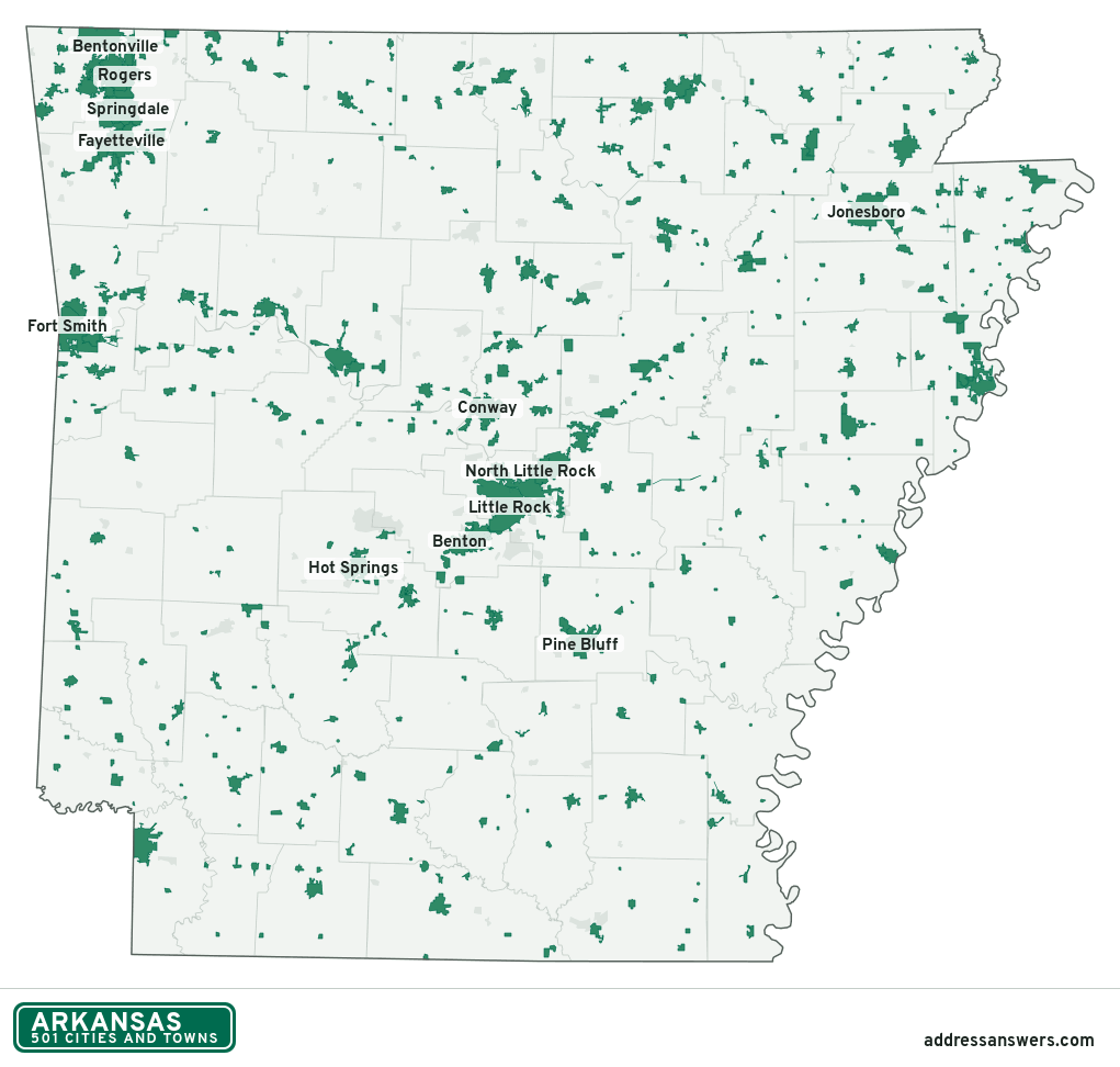
Arkansas city limits map image
The map above as a picture: every Arkansas city and town in green, with county lines. Boundaries from the Census Bureau, as of January 1, 2025.
You’re welcome to use it in a document or on your own site, with a link back to this page.
Download the map (PNG, 1,021 × 972)Questions about Arkansas city limits
How many cities and towns are in Arkansas?
Arkansas has 501 incorporated places: 315 cities and 186 towns, by the Census Bureau’s boundary files for 2025.
What is the largest city in Arkansas?
By population, Little Rock, with about 203,436 residents (2020–2024 American Community Survey 5-year estimates). It is also the largest by land area, at 121.2 square miles.
What is the smallest town in Arkansas?
By the Census Bureau’s estimate, Gilbert, with 16 residents. Estimates for places this small have a wide margin of error, so treat it as a rough count.
How much of Arkansas is unincorporated?
95% of its land and 982,986 of its residents (32%) are outside every city or town. There, local government is the county. The state also has 125 named unincorporated communities; the largest is Hot Springs Village.
Is Hot Springs Village, AR a city?
No. Hot Springs Village is a census-designated place: a community the Census Bureau maps for statistics, with no city government of its own. About 16,327 people live there, in unincorporated Garland County. An address there is outside city limits, even if its mailing address says otherwise.
Is East End, AR a city?
No. East End is a census-designated place: a community the Census Bureau maps for statistics, with no city government of its own. About 6,912 people live there, in unincorporated Saline County. An address there is outside city limits, even if its mailing address says otherwise.
Which cities and towns in Arkansas are in more than one county?
17 of the 501 cross a county line, by at least 1% of their land. The largest: Springdale (Washington and Benton), Cherokee Village (Sharp and Fulton), and Alexander (Saline and Pulaski). Check an address to see which county it’s in.
Which county in Arkansas has the most cities and towns?
Benton County, with 20 at least partly inside it. Every county in Arkansas has at least one.
Bordering states
More answers for a Arkansas address
Each tool checks the same address and puts its own answer first.
- County Census Your county, plus the township or town where those exist. Find your county
- School district Census The public school district that covers the address. Find your school district
- Flood zone FEMA The FEMA zone in plain English, and whether lenders require flood insurance. Check flood zone
- USDA home loans USDA Whether the property is in an area eligible for a USDA Rural Development loan. Check USDA eligibility
- Voting districts Census Your congressional district and your state senate and state house districts. Included in every check
Places, boundaries, land area and counties: US Census Bureau 2025 cartographic boundary files (boundaries as of January 1, 2025). A place is listed in each county that holds at least 1% of its land. Population: 2020–2024 American Community Survey 5-year estimates. Data updated October 24, 2026; page updated October 25, 2026. Boundaries change through annexation; your city or county has the official map.