Kansas city limits map
Kansas has 626 incorporated cities. They cover 2.9% of the state’s land and are home to 84% of its residents. Everyone else lives outside city limits, where local government is the county. Enter an address to see which side of a city line it’s on.
Result for
The map couldn’t load. The answers don’t depend on it.
The boundary couldn’t load. The answer doesn’t depend on it.
Census Geocoder match
More about this address
Sources and limits
- Census
- US Census Bureau Geocoder, current boundaries
- FEMA
- National Flood Hazard Layer, effective flood maps
- USDA
- Rural Development property eligibility
- Map
- Boundaries from Census TIGERweb, flood zones drawn by FEMA, eligible areas from USDA, base map © OpenStreetMap contributors
Census boundaries are updated once a year, so a recent annexation may not show yet. Informational only, not an official determination. Verify with your city or county.
Kansas at a glance
- Incorporated places
- 626
- 626 cities
- Residents in city limits
- 84%
- 2,469,004 of 2,947,197
- Land in city limits
- 2.9%
- 2,389 of 81,759 sq mi
- Counties
- 105
- Every one has at least one
- Unincorporated communities
- 114
- Largest: Fort Riley (8,606)
- Largest city
- Wichita
- 397,945 residents
How local government works in Kansas
The Census Bureau maps 1,392 townships in Kansas. Many have elected officers who look after rural roads; others exist only on maps. A township isn’t a city, so an address in one is outside city limits unless it’s also inside a city.
City limits maps for 5 Kansas cities
Every Kansas city with 100,000 or more residents has its own page: the boundary in detail, the places around it and its school districts.
All 626 cities in Kansas
Every incorporated place, largest first, with the counties it’s in and its size. An address inside one of these is inside city limits; anywhere else in the state is unincorporated.
| Name | County | Population | Land (sq mi) |
|---|---|---|---|
| Wichita | Sedgwick | 397,945 | 165.1 |
| Overland Park | Johnson | 200,306 | 75.3 |
| Kansas City | Wyandotte | 155,135 | 124.7 |
| Olathe | Johnson | 145,057 | 64.7 |
| Topeka | Shawnee | 125,786 | 61.9 |
| Lawrence | Douglas | 96,051 | 34.6 |
| Shawnee | Johnson | 68,542 | 42.0 |
| Lenexa | Johnson | 58,384 | 34.1 |
| Manhattan | Riley, Pottawatomie | 54,239 | 20.4 |
| Salina | Saline | 46,307 | 26.3 |
| Hutchinson | Reno | 39,709 | 25.4 |
| Leavenworth | Leavenworth | 37,195 | 24.3 |
| Leawood | Johnson | 33,809 | 15.1 |
| Garden City | Finney | 27,819 | 11.2 |
| Dodge City | Ford | 27,613 | 15.0 |
| Derby | Sedgwick | 26,062 | 11.1 |
| Gardner | Johnson | 24,526 | 14.9 |
| Emporia | Lyon | 24,131 | 12.4 |
| Prairie Village | Johnson | 22,874 | 6.21 |
| Junction City | Geary | 22,331 | 11.5 |
| Hays | Ellis | 21,143 | 8.74 |
| Pittsburg | Crawford | 20,637 | 13.5 |
| Liberal | Seward | 19,316 | 12.0 |
| Newton | Harvey | 18,397 | 14.8 |
| Andover | Butler | 15,965 | 11.0 |
| Great Bend | Barton | 14,479 | 10.5 |
| McPherson | McPherson | 13,995 | 8.19 |
| El Dorado | Butler | 12,769 | 9.95 |
| Ottawa | Franklin | 12,678 | 10.7 |
| Arkansas City | Cowley | 11,884 | 9.49 |
| Winfield | Cowley | 11,711 | 11.1 |
| Lansing | Leavenworth | 11,246 | 12.3 |
| Haysville | Sedgwick | 11,117 | 4.81 |
| Merriam | Johnson | 11,085 | 4.32 |
| Atchison | Atchison | 10,785 | 8.02 |
| Mission | Johnson | 9,915 | 2.67 |
| Parsons | Labette | 9,425 | 10.6 |
| Augusta | Butler | 9,216 | 4.25 |
| Spring Hill | Johnson, Miami | 9,120 | 9.95 |
| Bel Aire | Sedgwick | 9,043 | 7.04 |
| Coffeyville | Montgomery | 8,662 | 9.63 |
| Chanute | Neosho | 8,598 | 7.10 |
| Valley Center | Sedgwick | 8,590 | 8.10 |
| Independence | Montgomery | 8,422 | 7.50 |
| Bonner Springs | Wyandotte, Johnson | 7,839 | 15.6 |
| Park City | Sedgwick | 7,673 | 10.2 |
| Wellington | Sumner | 7,615 | 7.62 |
| Fort Scott | Bourbon | 7,555 | 5.58 |
| Basehor | Leavenworth | 7,491 | 7.14 |
| Maize | Sedgwick | 6,824 | 10.1 |
| Roeland Park | Johnson | 6,763 | 1.62 |
| Pratt | Pratt | 6,577 | 7.72 |
| Abilene | Dickinson | 6,449 | 4.83 |
| De Soto | Johnson | 6,414 | 25.7 |
| Mulvane | Sumner, Sedgwick | 6,171 | 4.29 |
| Eudora | Douglas | 6,119 | 3.35 |
| Goddard | Sedgwick | 6,030 | 5.64 |
| Tonganoxie | Leavenworth | 5,891 | 4.06 |
| Paola | Miami | 5,770 | 5.30 |
| Ulysses | Grant | 5,476 | 3.23 |
| Colby | Thomas | 5,387 | 3.72 |
| Iola | Allen | 5,348 | 4.64 |
| Louisburg | Miami | 5,094 | 4.88 |
| Concordia | Cloud | 5,015 | 4.51 |
| Baldwin City | Douglas | 4,911 | 2.96 |
| Edwardsville | Wyandotte | 4,724 | 9.04 |
| Wamego | Pottawatomie, Wabaunsee | 4,386 | 2.64 |
| Rose Hill | Butler | 4,246 | 2.25 |
| Russell | Russell | 4,217 | 4.86 |
| Osawatomie | Miami | 4,182 | 5.16 |
| Fairway | Johnson | 4,159 | 1.13 |
| Clay Center | Clay | 4,132 | 3.19 |
| Goodland | Sherman | 4,121 | 4.50 |
| Hugoton | Stevens | 3,974 | 2.10 |
| Baxter Springs | Cherokee | 3,855 | 3.15 |
| Scott City | Scott | 3,800 | 2.71 |
| Lindsborg | McPherson | 3,792 | 1.83 |
| Hesston | Harvey | 3,582 | 3.56 |
| Lyons | Rice | 3,553 | 2.65 |
| Mission Hills | Johnson | 3,548 | 2.04 |
| Larned | Pawnee | 3,423 | 2.41 |
| Marysville | Marshall | 3,422 | 4.56 |
| Frontenac | Crawford | 3,392 | 5.32 |
| Holton | Jackson | 3,387 | 2.68 |
| Garnett | Anderson | 3,202 | 3.08 |
| Hiawatha | Brown | 3,197 | 2.61 |
| Ellsworth | Ellsworth | 3,108 | 2.71 |
| Beloit | Mitchell | 3,029 | 3.92 |
| Kingman | Kingman | 2,957 | 3.59 |
| Kechi | Sedgwick | 2,901 | 6.03 |
| Columbus | Cherokee | 2,881 | 2.43 |
| Osage City | Osage | 2,828 | 3.15 |
| St. Marys | Pottawatomie | 2,788 | 1.18 |
| Girard | Crawford | 2,777 | 2.33 |
| Galena | Cherokee | 2,754 | 4.60 |
| South Hutchinson | Reno | 2,751 | 2.84 |
| Clearwater | Sedgwick | 2,716 | 2.08 |
| Hillsboro | Marion | 2,700 | 2.44 |
| Norton | Norton | 2,689 | 1.91 |
| Hoisington | Barton | 2,643 | 1.16 |
| Burlington | Coffey | 2,605 | 2.25 |
| Cheney | Sedgwick | 2,580 | 2.32 |
| Holcomb | Finney | 2,577 | 1.24 |
| Halstead | Harvey | 2,516 | 1.47 |
| Neodesha | Wilson | 2,503 | 1.40 |
| Sabetha | Nemaha, Brown | 2,471 | 3.33 |
| Sterling | Rice | 2,411 | 1.87 |
| Council Grove | Morris | 2,265 | 2.14 |
| Anthony | Harper | 2,246 | 3.22 |
| Lakin | Kearny | 2,243 | 0.95 |
| Eureka | Greenwood | 2,223 | 2.29 |
| Wellsville | Franklin | 2,216 | 1.72 |
| Ellinwood | Barton | 2,192 | 1.35 |
| Ellis | Ellis | 2,189 | 1.66 |
| Herington | Morris, Dickinson | 2,164 | 4.88 |
| North Newton | Harvey | 2,155 | 0.91 |
| Phillipsburg | Phillips | 2,130 | 1.70 |
| Cherryvale | Montgomery | 2,096 | 2.00 |
| Westwood | Johnson | 2,093 | 0.41 |
| Seneca | Nemaha | 2,090 | 1.79 |
| Belleville | Republic | 2,086 | 2.06 |
| Minneapolis | Ottawa | 2,043 | 1.83 |
| Grandview Plaza | Geary | 2,015 | 0.85 |
| Oakley | Logan, Gove +1 | 2,009 | 1.94 |
| Cimarron | Gray | 1,949 | 1.15 |
| Fredonia | Wilson | 1,945 | 2.44 |
| Oswego | Labette | 1,937 | 2.41 |
| Edgerton | Johnson | 1,924 | 8.65 |
| WaKeeney | Trego | 1,852 | 1.78 |
| Humboldt | Allen | 1,793 | 1.53 |
| Marion | Marion | 1,746 | 2.76 |
| Oberlin | Decatur | 1,734 | 1.91 |
| Syracuse | Hamilton | 1,699 | 4.10 |
| Ogden | Riley | 1,696 | 1.67 |
| Smith Center | Smith | 1,680 | 1.23 |
| Towanda | Butler | 1,668 | 0.93 |
| Elkhart | Morton | 1,661 | 2.05 |
| Plainville | Rooks | 1,656 | 1.20 |
| Stockton | Rooks | 1,656 | 1.66 |
| Moundridge | McPherson | 1,628 | 1.57 |
| Sedgwick | Harvey, Sedgwick | 1,614 | 1.63 |
| Horton | Brown | 1,610 | 1.77 |
| Douglass | Butler | 1,603 | 1.06 |
| Medicine Lodge | Barber | 1,578 | 1.20 |
| Conway Springs | Sumner | 1,573 | 0.99 |
| Wathena | Doniphan | 1,554 | 2.34 |
| Silver Lake | Shawnee | 1,553 | 0.56 |
| Johnson City | Stanton | 1,549 | 2.14 |
| Buhler | Reno | 1,525 | 0.74 |
| Pleasanton | Linn | 1,516 | 2.17 |
| Hill City | Graham | 1,511 | 1.68 |
| Sublette | Haskell | 1,500 | 1.06 |
| Colwich | Sedgwick | 1,492 | 1.34 |
| Chapman | Dickinson | 1,454 | 0.94 |
| Belle Plaine | Sumner | 1,449 | 0.83 |
| Caney | Montgomery | 1,431 | 1.36 |
| Valley Falls | Jefferson | 1,382 | 0.70 |
| Leoti | Wichita | 1,360 | 1.32 |
| Osborne | Osborne | 1,358 | 1.54 |
| Carbondale | Osage | 1,341 | 0.73 |
| Meade | Meade | 1,341 | 1.46 |
| Kinsley | Edwards | 1,328 | 1.30 |
| La Cygne | Linn | 1,327 | 1.53 |
| Inman | McPherson | 1,325 | 0.80 |
| Atwood | Rawlins | 1,320 | 1.06 |
| Haven | Reno | 1,313 | 0.78 |
| Yates Center | Woodson | 1,270 | 2.53 |
| Arma | Crawford | 1,239 | 1.13 |
| St. Francis | Cheyenne | 1,229 | 0.86 |
| Erie | Neosho | 1,216 | 1.27 |
| Peabody | Marion | 1,196 | 1.27 |
| St. John | Stafford | 1,172 | 1.94 |
| Plains | Meade | 1,171 | 1.00 |
| Ness City | Ness | 1,162 | 1.46 |
| Washington | Washington | 1,155 | 0.97 |
| La Crosse | Rush | 1,154 | 1.04 |
| Auburn | Shawnee | 1,144 | 0.70 |
| Harper | Harper | 1,136 | 1.62 |
| Garden Plain | Sedgwick | 1,126 | 1.13 |
| Oskaloosa | Jefferson | 1,113 | 0.99 |
| Overbrook | Osage | 1,113 | 0.54 |
| Rossville | Shawnee | 1,106 | 0.55 |
| Victoria | Ellis | 1,095 | 0.61 |
| Pomona | Franklin | 1,088 | 0.94 |
| Highland | Doniphan | 1,069 | 0.53 |
| Perry | Jefferson | 1,069 | 0.75 |
| Alma | Wabaunsee | 1,063 | 0.58 |
| Andale | Sedgwick | 1,062 | 0.59 |
| Sedan | Chautauqua | 1,050 | 0.82 |
| Elwood | Doniphan | 1,049 | 2.91 |
| Burlingame | Osage | 1,046 | 0.88 |
| Hoxie | Sheridan | 1,042 | 0.86 |
| Cottonwood Falls | Chase | 1,041 | 0.64 |
| St. George | Pottawatomie | 1,039 | 0.64 |
| Wakefield | Clay | 1,031 | 0.50 |
| Lyndon | Osage | 1,023 | 0.89 |
| Lincoln Center | Lincoln | 1,017 | 1.25 |
| Galva | McPherson | 1,002 | 0.50 |
| Nickerson | Reno | 1,001 | 1.30 |
| Spearville | Ford | 998 | 0.63 |
| Altamont | Labette | 993 | 1.70 |
| Chetopa | Labette | 977 | 1.36 |
| Caldwell | Sumner | 976 | 1.08 |
| Oxford | Sumner | 964 | 0.91 |
| Linn Valley | Linn | 962 | 3.18 |
| Americus | Lyon | 955 | 1.08 |
| Quinter | Gove | 953 | 1.01 |
| Riley | Riley | 943 | 0.51 |
| Lake Quivira | Johnson, Wyandotte | 940 | 1.48 |
| Hoyt | Jackson | 935 | 0.47 |
| Benton | Butler | 927 | 1.54 |
| Madison | Greenwood | 925 | 0.58 |
| Mankato | Jewell | 925 | 0.98 |
| Eastborough | Sedgwick | 919 | 0.39 |
| Scranton | Osage | 911 | 1.08 |
| Solomon | Dickinson | 892 | 0.86 |
| Whitewater | Butler | 886 | 0.41 |
| Blue Rapids | Marshall | 870 | 1.98 |
| McLouth | Jefferson | 864 | 0.58 |
| Montezuma | Gray | 864 | 1.02 |
| Weir | Cherokee | 855 | 1.14 |
| Satanta | Haskell | 837 | 0.62 |
| Minneola | Clark | 835 | 0.46 |
| Wilson | Ellsworth | 833 | 0.60 |
| Hanover | Washington | 828 | 0.60 |
| Troy | Doniphan | 824 | 0.97 |
| Sharon Springs | Wallace | 817 | 0.90 |
| Kiowa | Barber | 811 | 1.11 |
| Stafford | Stafford | 809 | 0.92 |
| Burrton | Harvey | 808 | 0.90 |
| Udall | Cowley | 807 | 0.54 |
| Clyde | Cloud | 791 | 0.67 |
| Effingham | Atchison | 786 | 0.62 |
| Coldwater | Comanche | 784 | 2.56 |
| Maple Hill | Wabaunsee | 772 | 0.24 |
| Mound City | Linn | 768 | 1.16 |
| Mount Hope | Sedgwick | 763 | 1.35 |
| Lebo | Coffey | 760 | 0.97 |
| Tribune | Greeley | 758 | 0.74 |
| Downs | Osborne | 749 | 1.12 |
| Waterville | Marshall | 748 | 0.49 |
| Ashland | Clark | 738 | 1.69 |
| Lecompton | Douglas | 736 | 1.23 |
| Dighton | Lane | 733 | 0.87 |
| Onaga | Pottawatomie | 727 | 0.66 |
| Frankfort | Marshall | 726 | 1.01 |
| Greensburg | Kiowa | 722 | 1.79 |
| Meriden | Jefferson | 716 | 0.77 |
| Nortonville | Jefferson | 715 | 0.43 |
| Enterprise | Dickinson | 710 | 0.67 |
| Canton | McPherson | 706 | 0.50 |
| Westmoreland | Pottawatomie | 703 | 0.56 |
| Cherokee | Crawford, Cherokee | 699 | 0.82 |
| Bucklin | Ford | 652 | 0.58 |
| Kensington | Smith | 652 | 0.34 |
| Bennington | Ottawa | 651 | 0.42 |
| Macksville | Stafford | 651 | 1.00 |
| Deerfield | Kearny | 647 | 0.48 |
| Pretty Prairie | Reno | 641 | 0.58 |
| Bird City | Cheyenne | 633 | 2.27 |
| St. Paul | Neosho | 631 | 1.13 |
| Waverly | Coffey | 625 | 0.73 |
| Leon | Butler | 607 | 0.75 |
| Ozawkie | Jefferson | 604 | 0.30 |
| Haviland | Kiowa | 603 | 0.49 |
| Goessel | Marion | 600 | 0.38 |
| Fowler | Meade | 599 | 0.47 |
| Logan | Phillips | 598 | 1.50 |
| Marquette | McPherson | 585 | 0.48 |
| Jetmore | Hodgeman | 580 | 4.21 |
| Olpe | Lyon | 565 | 0.70 |
| Burden | Cowley | 554 | 0.52 |
| Kanopolis | Ellsworth | 552 | 1.18 |
| Attica | Harper | 543 | 0.63 |
| Argonia | Sumner | 542 | 0.70 |
| Rolla | Morton | 542 | 0.37 |
| Dexter | Cowley | 540 | 0.28 |
| Bronson | Bourbon | 537 | 0.45 |
| Cedar Vale | Chautauqua | 529 | 0.75 |
| Parkerfield | Cowley | 527 | 0.91 |
| Almena | Norton | 523 | 0.60 |
| Florence | Marion | 522 | 0.77 |
| Assaria | Saline | 521 | 0.23 |
| Howard | Elk | 516 | 0.71 |
| Leonardville | Riley | 514 | 0.31 |
| Potwin | Butler | 513 | 0.23 |
| Gas | Allen | 512 | 0.72 |
| LeRoy | Coffey | 510 | 0.82 |
| Richmond | Franklin | 503 | 0.34 |
| Thayer | Neosho | 502 | 0.54 |
| Centralia | Nemaha | 501 | 0.46 |
| La Harpe | Allen | 492 | 0.80 |
| Protection | Comanche | 492 | 0.93 |
| Chase | Rice | 490 | 0.28 |
| Lewis | Edwards | 489 | 0.31 |
| Strong City | Chase | 488 | 0.55 |
| Hope | Dickinson | 485 | 0.39 |
| Bentley | Sedgwick | 480 | 0.30 |
| The Highlands | Reno | 479 | 1.03 |
| Glen Elder | Mitchell | 476 | 0.44 |
| Miltonvale | Cloud | 474 | 0.75 |
| Moran | Allen | 472 | 0.42 |
| Linn | Washington | 470 | 0.34 |
| Jewell | Jewell | 469 | 0.41 |
| Westwood Hills | Johnson | 469 | 0.06 |
| Axtell | Marshall | 468 | 0.52 |
| Altoona | Wilson | 467 | 0.53 |
| Uniontown | Bourbon | 467 | 0.21 |
| Greeley County | Independent city | 465 | 777.4 |
| Brewster | Thomas | 459 | 0.26 |
| White City | Morris | 458 | 1.24 |
| Claflin | Barton | 455 | 0.34 |
| Alta Vista | Wabaunsee | 443 | 0.35 |
| Gypsum | Saline | 443 | 0.37 |
| Clifton | Washington, Clay | 442 | 0.41 |
| Mulberry | Crawford | 442 | 0.47 |
| Norwich | Kingman | 437 | 0.40 |
| Hartford | Lyon | 428 | 0.40 |
| Natoma | Osborne | 427 | 0.42 |
| Eskridge | Wabaunsee | 419 | 0.52 |
| Winchester | Jefferson | 417 | 0.33 |
| Gorham | Russell | 416 | 0.24 |
| Cunningham | Kingman | 414 | 0.46 |
| Kismet | Seward | 414 | 0.24 |
| Otis | Rush | 413 | 0.31 |
| Fontana | Miami | 409 | 0.90 |
| Arlington | Reno | 407 | 1.23 |
| Bazine | Ness | 406 | 0.45 |
| Lucas | Russell | 405 | 0.61 |
| Little River | Rice | 402 | 0.39 |
| New Strawn | Coffey | 396 | 0.79 |
| Gridley | Coffey | 393 | 0.43 |
| Glasco | Cloud | 388 | 0.33 |
| Holyrood | Ellsworth | 377 | 0.48 |
| Williamsburg | Franklin | 372 | 0.97 |
| Scammon | Cherokee | 371 | 0.63 |
| Copeland | Gray | 365 | 0.23 |
| McFarland | Wabaunsee | 363 | 0.18 |
| Everest | Brown | 356 | 0.23 |
| Moline | Elk | 354 | 0.34 |
| Quenemo | Osage | 353 | 0.44 |
| Cawker City | Mitchell | 352 | 1.01 |
| Melvern | Osage | 352 | 0.36 |
| Mayetta | Jackson | 347 | 0.18 |
| Fairview | Brown | 342 | 0.34 |
| Grinnell | Gove | 342 | 0.49 |
| Wetmore | Nemaha | 342 | 0.39 |
| Mound Valley | Labette | 341 | 0.64 |
| Milford | Geary | 337 | 0.57 |
| Whiting | Jackson | 337 | 1.01 |
| Colony | Anderson | 335 | 0.48 |
| Turon | Reno | 334 | 0.45 |
| Burdett | Pawnee | 329 | 0.26 |
| Lancaster | Atchison | 325 | 0.20 |
| Delphos | Ottawa | 320 | 0.59 |
| Greenleaf | Washington | 320 | 0.45 |
| Ingalls | Gray | 315 | 0.26 |
| Sylvan Grove | Lincoln | 314 | 0.39 |
| Linwood | Leavenworth | 312 | 0.59 |
| McCune | Crawford | 308 | 0.32 |
| Longton | Elk | 302 | 1.18 |
| Elbing | Butler | 300 | 0.18 |
| Easton | Leavenworth | 299 | 0.17 |
| Burns | Marion | 297 | 0.34 |
| Edna | Labette | 297 | 0.39 |
| Scandia | Republic | 288 | 0.47 |
| Selden | Sheridan | 288 | 0.30 |
| Allen | Lyon | 287 | 0.28 |
| Buffalo | Wilson | 282 | 0.32 |
| Dearing | Montgomery | 279 | 1.51 |
| Ransom | Ness | 279 | 0.35 |
| Neosho Rapids | Lyon | 276 | 0.50 |
| Prescott | Linn | 276 | 0.28 |
| South Haven | Sumner | 276 | 1.00 |
| Parker | Linn | 274 | 0.28 |
| Olsburg | Pottawatomie | 269 | 0.23 |
| Toronto | Woodson | 260 | 0.36 |
| Pawnee Rock | Barton | 258 | 0.28 |
| McDonald | Rawlins | 249 | 0.22 |
| Arcadia | Crawford | 248 | 0.43 |
| Elk City | Montgomery | 245 | 0.34 |
| Agra | Phillips | 244 | 0.25 |
| Greeley | Anderson | 243 | 0.34 |
| Dwight | Morris | 242 | 0.36 |
| Tipton | Mitchell | 241 | 0.25 |
| Walnut | Crawford | 237 | 1.47 |
| Partridge | Reno | 236 | 0.31 |
| Princeton | Franklin | 236 | 0.34 |
| Tescott | Ottawa | 235 | 0.39 |
| Blue Mound | Linn | 234 | 0.64 |
| Denison | Jackson | 232 | 0.11 |
| Grainfield | Gove | 232 | 0.46 |
| Iuka | Pratt | 231 | 0.66 |
| Ford | Ford | 228 | 0.42 |
| Geuda Springs | Sumner, Cowley | 223 | 0.34 |
| Lane | Franklin | 223 | 0.23 |
| Walton | Harvey | 223 | 0.31 |
| Winona | Logan | 221 | 0.26 |
| Hardtner | Barber | 216 | 0.28 |
| Mullinville | Kiowa | 214 | 0.64 |
| Geneseo | Rice | 213 | 0.59 |
| Hanston | Hodgeman | 213 | 0.27 |
| Mapleton | Bourbon | 213 | 0.50 |
| Morrill | Brown | 210 | 0.20 |
| Bushton | Rice | 201 | 0.23 |
| Tampa | Marion | 201 | 0.18 |
| McCracken | Rush | 200 | 1.00 |
| Latham | Butler | 199 | 0.22 |
| Reading | Lyon | 198 | 0.21 |
| Norcatur | Decatur | 197 | 1.00 |
| Palco | Rooks | 197 | 0.27 |
| Sylvia | Reno | 195 | 0.29 |
| Cuba | Republic | 192 | 0.29 |
| Tyro | Montgomery | 192 | 0.46 |
| Brookville | Saline | 191 | 0.58 |
| Lebanon | Smith | 191 | 0.32 |
| Viola | Sedgwick | 190 | 0.16 |
| Kincaid | Anderson | 188 | 0.50 |
| Corning | Nemaha | 187 | 0.30 |
| Beattie | Marshall | 185 | 0.23 |
| Mission Woods | Johnson | 184 | 0.09 |
| Randall | Jewell | 184 | 0.17 |
| Lenora | Norton | 183 | 0.48 |
| Lehigh | Marion | 182 | 0.32 |
| Lincolnville | Marion | 181 | 0.22 |
| Schoenchen | Ellis | 181 | 0.12 |
| Moscow | Stevens | 180 | 0.17 |
| Olivet | Osage | 180 | 0.25 |
| Circleville | Jackson | 179 | 0.25 |
| Rush Center | Rush | 179 | 0.36 |
| Emmett | Pottawatomie | 178 | 0.20 |
| Randolph | Riley | 178 | 0.27 |
| Barnes | Washington | 177 | 0.17 |
| Delia | Jackson | 177 | 0.11 |
| Morganville | Clay | 176 | 0.34 |
| Belvue | Pottawatomie | 175 | 0.12 |
| Bogue | Graham | 175 | 0.26 |
| Louisville | Pottawatomie | 175 | 0.50 |
| Severy | Greenwood | 175 | 0.49 |
| Jamestown | Cloud | 174 | 0.29 |
| Havensville | Pottawatomie | 172 | 0.15 |
| Atlanta | Cowley | 169 | 0.48 |
| Paxico | Wabaunsee | 166 | 0.14 |
| Wilsey | Morris | 164 | 0.27 |
| Courtland | Republic | 163 | 0.27 |
| Westphalia | Anderson | 161 | 0.20 |
| Herndon | Rawlins | 159 | 0.32 |
| Hamilton | Greenwood | 158 | 0.31 |
| Munden | Republic | 158 | 0.19 |
| Dorrance | Russell | 156 | 0.34 |
| Prairie View | Phillips | 156 | 0.15 |
| Cassoday | Butler | 154 | 0.34 |
| Robinson | Brown | 154 | 0.23 |
| Simpson | Mitchell, Cloud | 154 | 0.26 |
| West Mineral | Cherokee | 154 | 0.34 |
| Kanorado | Sherman | 153 | 0.26 |
| Netawaka | Jackson | 151 | 0.97 |
| Offerle | Edwards | 151 | 0.27 |
| Palmer | Washington | 149 | 0.31 |
| Fall River | Greenwood | 148 | 0.22 |
| Republic | Republic | 148 | 0.23 |
| Smolan | Saline | 148 | 0.11 |
| Rexford | Thomas | 146 | 0.26 |
| Admire | Lyon | 144 | 0.32 |
| New Cambria | Saline | 144 | 0.18 |
| Grenola | Elk | 142 | 0.46 |
| Manter | Stanton | 142 | 0.25 |
| Bison | Rush | 141 | 0.26 |
| Muscotah | Atchison | 141 | 0.33 |
| Galesburg | Neosho | 139 | 0.17 |
| Peru | Chautauqua | 139 | 0.32 |
| Lorraine | Ellsworth | 137 | 0.25 |
| Oneida | Nemaha | 137 | 0.23 |
| Woodbine | Dickinson | 137 | 0.16 |
| Bern | Nemaha | 136 | 0.28 |
| Harveyville | Wabaunsee | 136 | 0.13 |
| Long Island | Phillips | 136 | 0.41 |
| Utica | Ness | 135 | 0.24 |
| Goff | Nemaha | 133 | 0.21 |
| Sharon | Barber | 133 | 0.28 |
| Beverly | Lincoln | 132 | 0.20 |
| Neosho Falls | Woodson | 132 | 0.51 |
| Rantoul | Franklin | 130 | 0.15 |
| Summerfield | Marshall | 128 | 0.34 |
| Damar | Rooks | 126 | 0.19 |
| Elk Falls | Elk | 126 | 0.73 |
| Garfield | Pawnee | 126 | 0.54 |
| Ensign | Gray | 125 | 0.29 |
| Alton | Osborne | 121 | 0.31 |
| Luray | Russell | 121 | 0.33 |
| Hepler | Crawford | 120 | 1.00 |
| Haddam | Washington | 118 | 0.34 |
| Jennings | Decatur | 118 | 0.27 |
| White Cloud | Doniphan | 117 | 0.72 |
| Spivey | Kingman | 116 | 0.52 |
| Burr Oak | Jewell | 114 | 0.82 |
| Olmitz | Barton | 113 | 0.16 |
| Morland | Graham | 112 | 0.48 |
| Earlton | Neosho | 111 | 0.16 |
| Preston | Pratt | 111 | 0.44 |
| Liberty | Montgomery | 110 | 0.25 |
| Coats | Pratt | 109 | 0.23 |
| Denton | Doniphan | 109 | 0.15 |
| Oketo | Marshall | 109 | 0.10 |
| Raymond | Rice | 109 | 0.31 |
| Bunker Hill | Russell | 108 | 1.39 |
| Hudson | Stafford | 106 | 0.12 |
| Hunnewell | Sumner | 104 | 0.56 |
| Hazelton | Barber | 103 | 0.59 |
| Mayfield | Sumner | 102 | 0.30 |
| Albert | Barton | 100 | 0.24 |
| Niotaze | Chautauqua | 99 | 0.37 |
| Gem | Thomas | 98 | 0.33 |
| Barnard | Lincoln | 97 | 0.22 |
| Cullison | Pratt | 97 | 0.17 |
| Morrowville | Washington | 96 | 0.14 |
| Green | Clay | 95 | 0.20 |
| Fulton | Bourbon | 93 | 0.19 |
| Isabel | Barber | 93 | 0.25 |
| Savonburg | Allen | 93 | 0.19 |
| Chautauqua | Chautauqua | 91 | 0.42 |
| Agenda | Republic | 90 | 0.17 |
| Plevna | Reno | 90 | 0.23 |
| Formoso | Jewell | 89 | 0.25 |
| New Albany | Wilson | 88 | 0.18 |
| Abbyville | Reno | 87 | 0.27 |
| Alden | Rice | 87 | 0.15 |
| Liebenthal | Rush | 87 | 0.11 |
| Park | Gove | 86 | 0.31 |
| Woodston | Rooks | 86 | 0.21 |
| Zenda | Kingman | 86 | 0.22 |
| Latimer | Morris | 84 | 0.06 |
| Culver | Ottawa | 83 | 0.18 |
| Durham | Marion | 83 | 0.17 |
| Esbon | Jewell | 82 | 0.28 |
| Narka | Republic | 82 | 0.16 |
| Horace | Greeley | 81 | 0.24 |
| Willowbrook | Reno | 81 | 0.29 |
| Milan | Sumner | 80 | 0.13 |
| Seward | Stafford | 80 | 0.26 |
| Gove City | Gove | 79 | 0.24 |
| Ramona | Marion | 76 | 0.29 |
| Sawyer | Pratt | 76 | 0.18 |
| Powhattan | Brown | 74 | 0.14 |
| Elgin | Chautauqua | 72 | 0.19 |
| Wheaton | Pottawatomie | 72 | 0.15 |
| Redfield | Bourbon | 71 | 0.14 |
| Gaylord | Smith | 70 | 0.26 |
| Huron | Atchison | 70 | 0.07 |
| Portis | Osborne | 70 | 0.26 |
| Cambridge | Cowley | 69 | 0.18 |
| Collyer | Trego | 69 | 0.23 |
| Manchester | Dickinson | 69 | 0.16 |
| Soldier | Jackson | 68 | 0.15 |
| Willard | Shawnee | 67 | 0.11 |
| Rozel | Pawnee | 66 | 0.19 |
| Athol | Smith | 65 | 0.18 |
| Kirwin | Phillips | 63 | 0.92 |
| Roseland | Cherokee | 63 | 0.73 |
| Stark | Neosho | 63 | 0.16 |
| Coyville | Wilson | 62 | 0.27 |
| Benedict | Wilson | 61 | 0.15 |
| Elmdale | Chase | 61 | 0.17 |
| Dresden | Decatur | 60 | 0.90 |
| Bartlett | Labette | 58 | 0.13 |
| Hunter | Mitchell | 58 | 0.21 |
| Vining | Washington, Clay | 58 | 0.21 |
| Nashville | Kingman | 57 | 0.21 |
| Elsmore | Allen | 56 | 0.15 |
| Havana | Montgomery | 55 | 0.16 |
| Parkerville | Morris | 55 | 0.13 |
| Vermillion | Marshall | 52 | 0.21 |
| Windom | McPherson | 52 | 0.20 |
| Englewood | Clark | 51 | 1.13 |
| Longford | Clay | 51 | 0.14 |
| Glade | Phillips | 50 | 0.27 |
| Zurich | Rooks | 50 | 0.18 |
| Edmond | Norton | 49 | 0.17 |
| Langdon | Reno | 49 | 0.10 |
| Leona | Doniphan | 49 | 0.06 |
| Matfield Green | Chase | 48 | 0.14 |
| Reserve | Brown | 48 | 0.12 |
| Wallace | Wallace | 48 | 0.40 |
| Mahaska | Washington | 47 | 0.22 |
| Bushong | Lyon | 46 | 0.15 |
| Climax | Greenwood | 46 | 0.12 |
| Frederick | Rice | 40 | 0.19 |
| Lone Elm | Anderson | 40 | 0.07 |
| Severance | Doniphan | 37 | 0.14 |
| Belpre | Edwards | 36 | 0.41 |
| Bluff City | Harper | 36 | 0.51 |
| Timken | Rush | 36 | 0.13 |
| Sun City | Barber | 35 | 0.15 |
| Willis | Brown | 35 | 0.16 |
| Clayton | Norton, Decatur | 33 | 0.42 |
| Susank | Barton | 31 | 0.10 |
| Coolidge | Hamilton | 28 | 0.43 |
| Danville | Harper | 28 | 0.08 |
| Carlton | Dickinson | 27 | 0.17 |
| Lost Springs | Marion | 27 | 0.22 |
| Russell Springs | Logan | 26 | 0.71 |
| Aurora | Cloud | 25 | 0.10 |
| Paradise | Russell | 25 | 0.25 |
| Alexander | Rush | 24 | 0.26 |
| Menlo | Thomas | 24 | 0.12 |
| Wilmore | Comanche | 24 | 0.18 |
| Virgil | Greenwood | 23 | 0.56 |
| Bassett | Allen | 22 | 0.07 |
| Galatia | Barton | 20 | 0.35 |
| Oak Hill | Clay | 19 | 0.05 |
| Webber | Jewell | 19 | 0.12 |
| Labette | Labette | 17 | 0.22 |
| Richfield | Morton | 17 | 1.00 |
| Waldo | Russell | 17 | 0.38 |
| Dunlap | Morris | 16 | 0.25 |
| Radium | Stafford | 16 | 0.04 |
| Scottsville | Mitchell | 15 | 0.25 |
| Brownell | Ness | 14 | 0.20 |
| Hamlin | Brown | 14 | 0.09 |
| Byers | Pratt | 11 | 0.17 |
| Hollenberg | Washington | 9 | 0.07 |
| Cedar Point | Chase | 8 | 0.07 |
| Speed | Phillips | 6 | 0.15 |
| Penalosa | Kingman | 5 | 0.10 |
| Waldron | Harper | 5 | 0.31 |
| Cedar | Smith | 0 | 0.18 |
Showing 1–50 of 626
Unincorporated communities in Kansas
Census-designated places: named communities the Census Bureau maps for statistics, with no city government of their own. An address in one is outside city limits, even when its mailing address names a city. Kansas has 114.
| Community | County | Population | Land (sq mi) |
|---|---|---|---|
| Fort Riley | Riley | 8,606 | 6.41 |
| Oaklawn-Sunview | Sedgwick | 2,789 | 0.54 |
| McConnell AFB | Sedgwick | 1,907 | 4.15 |
| Wilroads Gardens | Ford | 955 | 2.25 |
| Vassar | Osage | 832 | 4.86 |
| Riverton | Cherokee | 769 | 2.24 |
| Franklin | Crawford | 650 | 1.71 |
| Tecumseh | Shawnee | 457 | 3.57 |
| Chicopee | Crawford | 412 | 3.16 |
| Healy | Lane | 347 | 3.46 |
| Elyria | McPherson | 307 | 4.78 |
| Lowell | Cherokee | 278 | 0.31 |
| Munjor | Ellis | 247 | 2.30 |
| Welda | Anderson | 233 | 0.93 |
| Rosalia | Butler | 219 | 1.27 |
| Wakarusa | Shawnee | 209 | 4.96 |
| Dennis | Labette | 198 | 1.51 |
| Bremen | Marshall | 192 | 1.69 |
| Catharine | Ellis | 186 | 1.77 |
| Milton | Sumner | 185 | 4.44 |
| Keats | Riley | 182 | 0.46 |
| Weskan | Wallace | 171 | 2.64 |
| Bucyrus | Miami | 168 | 2.00 |
| Kickapoo Site 5 | Brown | 161 | 0.75 |
| St. Marks | Sedgwick | 156 | 0.98 |
| Bendena | Doniphan | 140 | 1.53 |
| Crestline | Cherokee | 139 | 1.78 |
| Radley | Crawford | 135 | 0.75 |
| Kipp | Saline | 129 | 0.81 |
| Kickapoo Tribal Center | Brown | 128 | 1.93 |
| Baileyville | Nemaha | 126 | 1.21 |
| Falun | Saline | 125 | 1.11 |
| Grantville | Jefferson | 122 | 0.61 |
| Hillsdale | Miami | 117 | 1.53 |
| Silverdale | Cowley | 116 | 1.04 |
| Wright | Ford | 106 | 2.06 |
| Monument | Logan | 99 | 0.53 |
| Fort Dodge | Ford | 93 | 0.18 |
| Home | Marshall | 92 | 3.96 |
| Rock | Cowley | 90 | 0.40 |
| Big Bow | Stanton | 86 | 5.03 |
| Niles | Ottawa | 84 | 0.44 |
| Mentor | Saline | 83 | 0.39 |
| Ringo | Crawford | 82 | 1.50 |
| Croweburg | Crawford | 80 | 0.59 |
| Lafontaine | Wilson | 78 | 2.00 |
| Wabaunsee | Wabaunsee | 76 | 1.36 |
| Detroit | Dickinson | 75 | 0.49 |
| Devon | Bourbon | 73 | 0.71 |
| Ada | Ottawa | 67 | 2.54 |
| Stuttgart | Phillips | 65 | 0.66 |
| Kickapoo Site 7 | Brown | 64 | 0.51 |
| Levant | Thomas | 63 | 1.01 |
| Greenwich | Sedgwick | 62 | 0.13 |
| Farlington | Crawford | 61 | 0.92 |
| Yale | Crawford | 60 | 0.99 |
| Odin | Barton | 58 | 4.00 |
| Pilsen | Marion | 51 | 1.40 |
| Bavaria | Saline | 50 | 0.23 |
| Newbury | Wabaunsee | 50 | 0.90 |
| Furley | Sedgwick | 49 | 0.25 |
| Kickapoo Site 1 | Brown | 48 | 0.50 |
| Codell | Rooks | 47 | 0.75 |
| Talmage | Dickinson | 44 | 0.10 |
| Piqua | Woodson | 40 | 3.97 |
| Somerset | Miami | 40 | 0.44 |
| Hallowell | Cherokee | 39 | 0.86 |
| Beaumont | Butler | 38 | 0.55 |
| St. Benedict | Nemaha | 36 | 1.44 |
| Opolis | Crawford | 35 | 0.69 |
| Burdick | Morris | 34 | 1.01 |
| Idana | Clay | 33 | 0.34 |
| Mildred | Allen | 33 | 0.68 |
| Murdock | Kingman | 32 | 0.23 |
| South Mound | Neosho | 31 | 0.99 |
| Williamstown | Jefferson | 31 | 0.12 |
| Bridgeport | Saline | 29 | 0.21 |
| Neal | Greenwood | 27 | 0.20 |
| Piedmont | Greenwood | 27 | 3.70 |
| Sycamore | Montgomery | 24 | 1.94 |
| Yoder | Reno | 24 | 2.70 |
| Garland | Bourbon | 22 | 0.21 |
| Peck | Sedgwick | 22 | 0.35 |
| Ames | Cloud | 21 | 0.43 |
| Eastshore | Marion | 20 | 0.96 |
| Kickapoo Site 2 | Brown | 15 | 0.85 |
| Ludell | Rawlins | 14 | 0.38 |
| Marienthal | Wichita | 13 | 2.00 |
| New Salem | Cowley | 12 | 0.37 |
| Wells | Ottawa | 10 | 1.40 |
| Harris | Anderson | 9 | 0.35 |
| Ogallah | Trego | 8 | 1.60 |
| Woodruff | Phillips | 8 | 2.01 |
| Norway | Republic | 6 | 2.27 |
| Edson | Sherman | 5 | 0.70 |
| Kelly | Nemaha | 1 | 0.24 |
| Asherville | Mitchell | 0 | 1.18 |
| Bala | Riley | 0 | 0.43 |
| Beaver | Barton | 0 | 6.11 |
| Centerville | Linn | 0 | 1.84 |
| Centropolis | Franklin | 0 | 0.33 |
| Herkimer | Marshall | 0 | 0.94 |
| Ionia | Jewell | 0 | 0.97 |
| Kickapoo Site 6 | Brown | 0 | 0.31 |
| Lake City | Barber | 0 | 2.40 |
| Mont Ida | Anderson | 0 | 0.24 |
| Navarre | Dickinson | 0 | 1.65 |
| Nicodemus | Graham | 0 | 0.88 |
| Pierceville | Finney | 0 | 2.06 |
| Roxbury | McPherson | 0 | 4.03 |
| Shallow Water | Scott | 0 | 0.50 |
| Urbana | Neosho | 0 | 1.70 |
| Wayside | Montgomery | 0 | 0.17 |
| Zeandale | Riley | 0 | 1.36 |
Showing 1–50 of 114
Counties in Kansas
105 counties, with how many cities have land in each and the largest whose main county it is.
| County | Cities | Largest | Population | Land (sq mi) |
|---|---|---|---|---|
| Johnson County | 20 | Overland Park | 620,631 | 473.6 |
| Sedgwick County | 20 | Wichita | 528,226 | 997.0 |
| Shawnee County | 5 | Topeka | 178,025 | 544.0 |
| Wyandotte County | 4 | Kansas City | 167,654 | 151.6 |
| Douglas County | 4 | Lawrence | 120,302 | 455.8 |
| Leavenworth County | 6 | Leavenworth | 83,123 | 463.4 |
| Riley County | 5 | Manhattan | 71,946 | 609.7 |
| Butler County | 13 | Andover | 68,287 | 1,430 |
| Reno County | 15 | Hutchinson | 61,553 | 1,255 |
| Saline County | 6 | Salina | 53,668 | 720.2 |
| Crawford County | 10 | Pittsburg | 39,008 | 589.8 |
| Finney County | 2 | Garden City | 38,084 | 1,302 |
| Geary County | 3 | Junction City | 35,815 | 384.7 |
| Miami County | 5 | Paola | 34,938 | 575.9 |
| Cowley County | 9 | Arkansas City | 34,411 | 1,126 |
| Ford County | 4 | Dodge City | 34,074 | 1,098 |
| Harvey County | 7 | Newton | 33,756 | 539.8 |
| Lyon County | 9 | Emporia | 32,186 | 847.5 |
| Montgomery County | 9 | Coffeyville | 30,940 | 643.6 |
| McPherson County | 8 | McPherson | 30,205 | 898.3 |
| Ellis County | 4 | Hays | 28,920 | 899.9 |
| Pottawatomie County | 12 | Wamego | 26,204 | 840.7 |
| Franklin County | 8 | Ottawa | 26,106 | 571.8 |
| Barton County | 9 | Great Bend | 25,097 | 895.3 |
| Sumner County | 12 | Wellington | 22,353 | 1,182 |
| Seward County | 2 | Liberal | 21,486 | 639.7 |
| Labette County | 8 | Parsons | 19,869 | 645.4 |
| Cherokee County | 8 | Baxter Springs | 19,151 | 587.6 |
| Dickinson County | 9 | Abilene | 18,445 | 847.1 |
| Jefferson County | 8 | Valley Falls | 18,349 | 532.6 |
| Atchison County | 5 | Atchison | 16,208 | 431.2 |
| Osage County | 9 | Osage City | 15,744 | 705.5 |
| Neosho County | 7 | Chanute | 15,656 | 571.5 |
| Bourbon County | 6 | Fort Scott | 14,394 | 635.5 |
| Jackson County | 9 | Holton | 13,341 | 656.2 |
| Allen County | 8 | Iola | 12,483 | 500.3 |
| Marion County | 12 | Hillsboro | 11,754 | 944.3 |
| Nemaha County | 8 | Sabetha | 10,160 | 717.4 |
| Marshall County | 9 | Marysville | 9,993 | 900.2 |
| Linn County | 7 | Pleasanton | 9,767 | 594.1 |
| Rice County | 9 | Lyons | 9,350 | 726.2 |
| Brown County | 11 | Hiawatha | 9,343 | 570.9 |
| Pratt County | 7 | Pratt | 9,127 | 735.0 |
| Cloud County | 7 | Concordia | 8,898 | 715.3 |
| Wilson County | 7 | Neodesha | 8,505 | 570.4 |
| Coffey County | 6 | Burlington | 8,308 | 626.9 |
| Clay County | 8 | Clay Center | 8,048 | 645.3 |
| Thomas County | 6 | Colby | 7,885 | 1,075 |
| Anderson County | 6 | Garnett | 7,834 | 579.6 |
| Doniphan County | 8 | Wathena | 7,503 | 393.5 |
| Grant County | 1 | Ulysses | 7,229 | 574.8 |
| Kingman County | 7 | Kingman | 7,186 | 863.4 |
| Wabaunsee County | 8 | Alma | 7,009 | 794.3 |
| Russell County | 8 | Russell | 6,679 | 886.3 |
| Ellsworth County | 5 | Ellsworth | 6,360 | 715.6 |
| Pawnee County | 4 | Larned | 6,144 | 754.3 |
| Greenwood County | 7 | Eureka | 5,919 | 1,143 |
| Sherman County | 2 | Goodland | 5,858 | 1,056 |
| Ottawa County | 5 | Minneapolis | 5,819 | 720.7 |
| Mitchell County | 7 | Beloit | 5,779 | 701.8 |
| Gray County | 5 | Cimarron | 5,701 | 868.9 |
| Washington County | 12 | Washington | 5,533 | 894.8 |
| Harper County | 6 | Anthony | 5,400 | 801.3 |
| Norton County | 5 | Norton | 5,359 | 878.0 |
| Morris County | 8 | Council Grove | 5,340 | 695.3 |
| Stevens County | 2 | Hugoton | 5,162 | 727.4 |
| Scott County | 1 | Scott City | 5,027 | 717.6 |
| Phillips County | 8 | Phillipsburg | 4,813 | 885.9 |
| Rooks County | 6 | Plainville | 4,813 | 890.5 |
| Republic County | 8 | Belleville | 4,646 | 717.4 |
| Barber County | 7 | Medicine Lodge | 4,069 | 1,134 |
| Stafford County | 6 | St. John | 3,978 | 792.0 |
| Meade County | 3 | Meade | 3,903 | 978.1 |
| Kearny County | 2 | Lakin | 3,864 | 870.5 |
| Haskell County | 2 | Sublette | 3,641 | 577.5 |
| Smith County | 6 | Smith Center | 3,552 | 895.5 |
| Osborne County | 5 | Osborne | 3,452 | 892.5 |
| Chautauqua County | 6 | Sedan | 3,370 | 638.9 |
| Woodson County | 3 | Yates Center | 3,109 | 497.8 |
| Rush County | 8 | La Crosse | 2,947 | 717.8 |
| Lincoln County | 4 | Lincoln Center | 2,923 | 719.4 |
| Jewell County | 7 | Mankato | 2,916 | 910.0 |
| Gove County | 6 | Quinter | 2,799 | 1,072 |
| Edwards County | 4 | Kinsley | 2,779 | 621.9 |
| Trego County | 2 | WaKeeney | 2,777 | 889.5 |
| Decatur County | 5 | Oberlin | 2,726 | 893.5 |
| Logan County | 3 | Oakley | 2,707 | 1,073 |
| Ness County | 5 | Ness City | 2,653 | 1,075 |
| Cheyenne County | 2 | St. Francis | 2,628 | 1,020 |
| Morton County | 3 | Elkhart | 2,611 | 729.7 |
| Chase County | 5 | Cottonwood Falls | 2,561 | 773.1 |
| Rawlins County | 3 | Atwood | 2,516 | 1,069 |
| Hamilton County | 2 | Syracuse | 2,471 | 996.5 |
| Elk County | 5 | Howard | 2,453 | 644.3 |
| Sheridan County | 2 | Hoxie | 2,426 | 896.0 |
| Kiowa County | 3 | Greensburg | 2,422 | 722.6 |
| Graham County | 3 | Hill City | 2,389 | 898.5 |
| Wichita County | 1 | Leoti | 2,091 | 718.6 |
| Stanton County | 2 | Johnson City | 2,038 | 680.4 |
| Clark County | 3 | Minneola | 1,974 | 974.6 |
| Comanche County | 3 | Coldwater | 1,729 | 788.3 |
| Hodgeman County | 2 | Jetmore | 1,652 | 860.0 |
| Lane County | 1 | Dighton | 1,461 | 717.4 |
| Wallace County | 2 | Sharon Springs | 1,417 | 913.7 |
| Greeley County | 3 | Tribune | 1,304 | 778.4 |
Showing 1–50 of 105
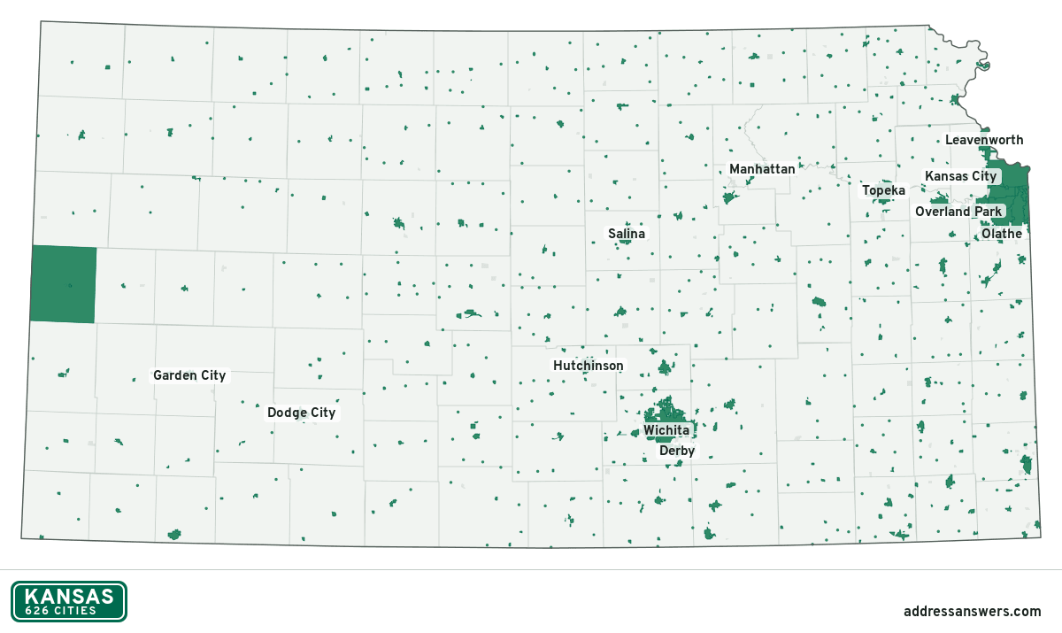
Kansas city limits map image
The map above as a picture: every Kansas city and town in green, with county lines. Boundaries from the Census Bureau, as of January 1, 2025.
You’re welcome to use it in a document or on your own site, with a link back to this page.
Download the map (PNG, 1,200 × 715)Questions about Kansas city limits
How many cities are in Kansas?
Kansas has 626 incorporated places: 626 cities, by the Census Bureau’s boundary files for 2025.
What is the largest city in Kansas?
By population, Wichita, with about 397,945 residents (2020–2024 American Community Survey 5-year estimates). By land area the largest is Greeley County, at 777.4 square miles (Wichita: 165.1).
What is the smallest city in Kansas?
By the Census Bureau’s estimate, Penalosa (tied with one other), with 5 residents. Estimates for places this small have a wide margin of error, so treat it as a rough count.
How much of Kansas is unincorporated?
97% of its land and 478,193 of its residents (16%) are outside every city. There, local government is the county. The state also has 114 named unincorporated communities; the largest is Fort Riley.
Is Fort Riley, KS a city?
No. Fort Riley is a census-designated place: a community the Census Bureau maps for statistics, with no city government of its own. About 8,606 people live there, in unincorporated Riley County. An address there is outside city limits, even if its mailing address says otherwise.
Is Oaklawn-Sunview, KS a city?
No. Oaklawn-Sunview is a census-designated place: a community the Census Bureau maps for statistics, with no city government of its own. About 2,789 people live there, in unincorporated Sedgwick County. An address there is outside city limits, even if its mailing address says otherwise.
Which cities in Kansas are in more than one county?
16 of the 626 cross a county line, by at least 1% of their land. The largest: Manhattan (Riley and Pottawatomie), Spring Hill (Johnson and Miami), and Bonner Springs (Wyandotte and Johnson). Check an address to see which county it’s in.
Which county in Kansas has the most cities?
Johnson County, with 20 at least partly inside it. Every county in Kansas has at least one.
Bordering states
More answers for a Kansas address
Each tool checks the same address and puts its own answer first.
- County Census Your county, plus the township or town where those exist. Find your county
- School district Census The public school district that covers the address. Find your school district
- Flood zone FEMA The FEMA zone in plain English, and whether lenders require flood insurance. Check flood zone
- USDA home loans USDA Whether the property is in an area eligible for a USDA Rural Development loan. Check USDA eligibility
- Voting districts Census Your congressional district and your state senate and state house districts. Included in every check
Places, boundaries, land area and counties: US Census Bureau 2025 cartographic boundary files (boundaries as of January 1, 2025). A place is listed in each county that holds at least 1% of its land. Population: 2020–2024 American Community Survey 5-year estimates. Data updated October 24, 2026; page updated October 25, 2026. Boundaries change through annexation; your city or county has the official map.