Iowa city limits map
Iowa has 939 incorporated cities. They cover 3.9% of the state’s land and are home to 81% of its residents. Everyone else lives outside city limits, where local government is the county. Enter an address to see which side of a city line it’s on.
Result for
The map couldn’t load. The answers don’t depend on it.
The boundary couldn’t load. The answer doesn’t depend on it.
Census Geocoder match
More about this address
Sources and limits
- Census
- US Census Bureau Geocoder, current boundaries
- FEMA
- National Flood Hazard Layer, effective flood maps
- USDA
- Rural Development property eligibility
- Map
- Boundaries from Census TIGERweb, flood zones drawn by FEMA, eligible areas from USDA, base map © OpenStreetMap contributors
Census boundaries are updated once a year, so a recent annexation may not show yet. Informational only, not an official determination. Verify with your city or county.
Iowa at a glance
- Incorporated places
- 939
- 939 cities
- Residents in city limits
- 81%
- 2,603,575 of 3,210,507
- Land in city limits
- 3.9%
- 2,201 of 55,854 sq mi
- Counties
- 99
- Every one has at least one
- Unincorporated communities
- 87
- Largest: Saylorville (3,366)
- Largest city
- Des Moines
- 212,421 residents
How local government works in Iowa
The Census Bureau maps 1,600 townships in Iowa. They have few duties of their own; the county is the main local government. A township isn’t a city, so an address in one is outside city limits unless it’s also inside a city.
City limits maps for 3 Iowa cities
Every Iowa city with 100,000 or more residents has its own page: the boundary in detail, the places around it and its school districts.
All 939 cities in Iowa
Every incorporated place, largest first, with the counties it’s in and its size. An address inside one of these is inside city limits; anywhere else in the state is unincorporated.
| Name | County | Population | Land (sq mi) |
|---|---|---|---|
| Des Moines | Polk, Warren | 212,421 | 88.2 |
| Cedar Rapids | Linn | 137,264 | 74.8 |
| Davenport | Scott | 100,913 | 64.2 |
| Sioux City | Woodbury | 86,101 | 59.4 |
| Iowa City | Johnson | 75,752 | 25.8 |
| Ankeny | Polk | 72,615 | 32.7 |
| West Des Moines | Polk, Dallas +2 | 71,083 | 47.5 |
| Ames | Story | 67,669 | 28.2 |
| Waterloo | Black Hawk | 67,008 | 61.6 |
| Council Bluffs | Pottawattamie | 62,586 | 43.0 |
| Dubuque | Dubuque | 59,174 | 31.3 |
| Urbandale | Polk, Dallas | 46,595 | 22.5 |
| Marion | Linn | 41,896 | 18.1 |
| Cedar Falls | Black Hawk | 40,888 | 29.5 |
| Bettendorf | Scott | 39,647 | 21.3 |
| Waukee | Dallas | 29,236 | 21.9 |
| Marshalltown | Marshall | 27,626 | 19.2 |
| Mason City | Cerro Gordo | 27,050 | 28.3 |
| Ottumwa | Wapello | 25,430 | 16.1 |
| Fort Dodge | Webster | 24,827 | 16.0 |
| Johnston | Polk | 24,384 | 19.5 |
| Clinton | Clinton | 24,322 | 35.6 |
| Burlington | Des Moines | 23,728 | 14.4 |
| Muscatine | Muscatine | 23,489 | 18.2 |
| Coralville | Johnson | 23,234 | 12.7 |
| Altoona | Polk | 21,495 | 13.4 |
| North Liberty | Johnson | 21,125 | 9.54 |
| Clive | Polk, Dallas | 19,012 | 7.66 |
| Grimes | Polk, Dallas | 16,366 | 13.8 |
| Indianola | Warren | 16,044 | 11.4 |
| Newton | Jasper | 15,700 | 11.3 |
| Norwalk | Warren, Polk | 14,183 | 11.6 |
| Boone | Boone | 12,424 | 9.25 |
| Oskaloosa | Mahaska | 11,504 | 8.06 |
| Storm Lake | Buena Vista | 11,428 | 5.43 |
| Spencer | Clay | 11,400 | 10.9 |
| Pleasant Hill | Polk | 11,136 | 10.8 |
| Pella | Marion | 10,720 | 9.34 |
| Le Mars | Plymouth | 10,640 | 8.79 |
| Waverly | Bremer | 10,494 | 11.3 |
| Carroll | Carroll | 10,208 | 6.03 |
| Fort Madison | Lee | 10,133 | 9.65 |
| Keokuk | Lee | 9,662 | 9.10 |
| Grinnell | Poweshiek | 9,505 | 5.69 |
| Fairfield | Jefferson | 9,456 | 6.61 |
| Mount Pleasant | Henry | 8,951 | 8.63 |
| Bondurant | Polk | 8,560 | 11.1 |
| Sioux Center | Sioux | 8,454 | 6.70 |
| Denison | Crawford | 8,260 | 6.54 |
| Perry | Dallas | 7,985 | 5.79 |
| Webster City | Hamilton | 7,769 | 9.20 |
| Clear Lake | Cerro Gordo | 7,607 | 10.8 |
| Decorah | Winneshiek | 7,535 | 7.24 |
| Knoxville | Marion | 7,473 | 4.62 |
| Creston | Union | 7,435 | 5.19 |
| Washington | Washington | 7,290 | 5.43 |
| Charles City | Floyd | 7,232 | 6.13 |
| Hiawatha | Linn | 7,206 | 4.76 |
| Nevada | Story | 6,983 | 6.06 |
| Eldridge | Scott | 6,818 | 9.76 |
| Atlantic | Cass | 6,763 | 8.29 |
| Adel | Dallas | 6,430 | 5.39 |
| Orange City | Sioux | 6,426 | 4.60 |
| Independence | Buchanan | 6,164 | 6.03 |
| Maquoketa | Jackson, Clinton | 6,075 | 4.52 |
| Polk City | Polk | 6,037 | 5.56 |
| Asbury | Dubuque | 5,989 | 3.18 |
| Estherville | Emmet | 5,839 | 5.39 |
| Oelwein | Fayette | 5,834 | 4.81 |
| Tiffin | Johnson | 5,737 | 4.32 |
| Anamosa | Jones | 5,629 | 2.52 |
| DeWitt | Clinton | 5,546 | 6.22 |
| Osceola | Clarke | 5,523 | 7.97 |
| Spirit Lake | Dickinson | 5,518 | 4.52 |
| Red Oak | Montgomery | 5,510 | 3.93 |
| Sheldon | O'Brien, Sioux | 5,474 | 4.83 |
| Winterset | Madison | 5,416 | 4.81 |
| Algona | Kossuth | 5,377 | 4.63 |
| Centerville | Appanoose | 5,372 | 4.84 |
| Clarinda | Page | 5,353 | 5.10 |
| Manchester | Delaware | 5,191 | 4.93 |
| Sergeant Bluff | Woodbury | 5,171 | 2.97 |
| Cherokee | Cherokee | 5,154 | 6.83 |
| Glenwood | Mills | 5,144 | 2.92 |
| Windsor Heights | Polk | 5,143 | 1.43 |
| Iowa Falls | Hardin | 5,038 | 5.67 |
| Vinton | Benton | 4,948 | 4.88 |
| Shenandoah | Page, Fremont | 4,892 | 3.74 |
| Harlan | Shelby | 4,891 | 4.42 |
| Humboldt | Humboldt | 4,771 | 4.65 |
| Le Claire | Scott | 4,735 | 4.65 |
| Camanche | Clinton | 4,550 | 8.86 |
| Huxley | Story | 4,544 | 3.41 |
| Evansdale | Black Hawk | 4,518 | 4.00 |
| Mount Vernon | Linn | 4,513 | 3.73 |
| Dyersville | Dubuque, Delaware | 4,423 | 6.98 |
| Hampton | Franklin | 4,306 | 4.42 |
| Forest City | Winnebago, Hancock | 4,290 | 4.59 |
| Carlisle | Polk, Warren | 4,255 | 5.97 |
| Chariton | Lucas | 4,242 | 3.77 |
| Jefferson | Greene | 4,152 | 6.02 |
| Monticello | Jones | 4,071 | 5.63 |
| Rock Valley | Sioux | 4,059 | 4.46 |
| Cresco | Howard | 3,908 | 3.34 |
| Waukon | Allamakee | 3,792 | 2.84 |
| West Liberty | Muscatine | 3,776 | 1.77 |
| Carter Lake | Pottawattamie | 3,767 | 1.79 |
| Albia | Monroe | 3,663 | 3.25 |
| Emmetsburg | Palo Alto | 3,648 | 3.79 |
| Eagle Grove | Wright | 3,593 | 4.10 |
| Osage | Mitchell | 3,561 | 2.24 |
| New Hampton | Chickasaw | 3,453 | 3.35 |
| Story City | Story | 3,398 | 2.97 |
| Williamsburg | Iowa | 3,360 | 3.37 |
| Robins | Linn | 3,332 | 6.02 |
| Milford | Dickinson | 3,311 | 2.15 |
| West Burlington | Des Moines | 3,189 | 4.84 |
| Solon | Johnson | 3,152 | 1.66 |
| Tipton | Cedar | 3,106 | 2.02 |
| Tama | Tama | 3,051 | 2.97 |
| Garner | Hancock | 3,049 | 2.13 |
| Postville | Allamakee, Clayton | 2,979 | 2.14 |
| Wilton | Muscatine, Cedar | 2,920 | 2.05 |
| Fairfax | Linn | 2,900 | 3.63 |
| Onawa | Monona | 2,839 | 5.27 |
| Grundy Center | Grundy | 2,809 | 2.57 |
| Madrid | Boone | 2,808 | 1.22 |
| Sibley | Osceola | 2,803 | 1.79 |
| Clarion | Wright | 2,770 | 3.36 |
| Bloomfield | Davis | 2,742 | 2.27 |
| Marengo | Iowa | 2,725 | 2.12 |
| Hudson | Black Hawk | 2,699 | 8.55 |
| Belmond | Wright | 2,694 | 2.83 |
| Kalona | Washington | 2,692 | 2.15 |
| Missouri Valley | Harrison | 2,666 | 3.32 |
| Rock Rapids | Lyon | 2,661 | 4.21 |
| Hawarden | Sioux | 2,658 | 2.77 |
| Eldora | Hardin | 2,617 | 4.28 |
| West Branch | Cedar, Johnson | 2,594 | 2.57 |
| Mitchellville | Polk, Jasper | 2,579 | 2.80 |
| Center Point | Linn | 2,562 | 2.73 |
| Jesup | Buchanan, Black Hawk | 2,561 | 1.88 |
| West Union | Fayette | 2,489 | 2.75 |
| Rockwell City | Calhoun | 2,401 | 4.21 |
| Belle Plaine | Benton | 2,380 | 3.18 |
| Denver | Bremer | 2,379 | 1.70 |
| Cascade | Dubuque, Jones | 2,375 | 1.92 |
| New London | Henry | 2,338 | 1.08 |
| Hull | Sioux | 2,317 | 1.44 |
| Bellevue | Jackson | 2,259 | 1.51 |
| Alta | Buena Vista | 2,250 | 1.08 |
| Atkins | Benton | 2,225 | 1.10 |
| Colfax | Jasper | 2,210 | 2.56 |
| Lamoni | Decatur | 2,207 | 3.95 |
| Ely | Linn | 2,186 | 1.69 |
| Dallas Center | Dallas | 2,161 | 5.41 |
| Audubon | Audubon | 2,130 | 1.93 |
| Monroe | Jasper | 2,120 | 1.70 |
| Columbus Junction | Louisa | 2,110 | 2.15 |
| Sumner | Bremer, Fayette | 2,106 | 2.46 |
| Lake Mills | Winnebago | 2,088 | 2.71 |
| La Porte City | Black Hawk | 2,071 | 2.56 |
| Northwood | Worth | 2,040 | 3.99 |
| Peosta | Dubuque | 2,040 | 2.83 |
| Granger | Dallas, Polk | 1,979 | 2.67 |
| Blue Grass | Scott, Muscatine | 1,972 | 3.16 |
| Ida Grove | Ida | 1,967 | 2.20 |
| Toledo | Tama | 1,966 | 2.29 |
| Sigourney | Keokuk | 1,954 | 2.16 |
| Durant | Cedar, Scott +1 | 1,946 | 1.23 |
| Mediapolis | Des Moines | 1,928 | 1.20 |
| Leon | Decatur | 1,899 | 3.13 |
| Pleasantville | Marion | 1,899 | 2.45 |
| Epworth | Dubuque | 1,894 | 1.86 |
| Greenfield | Adair | 1,894 | 1.80 |
| Farley | Dubuque | 1,889 | 1.62 |
| Sac City | Sac | 1,885 | 4.90 |
| Britt | Hancock | 1,882 | 1.34 |
| Ogden | Boone | 1,859 | 1.37 |
| Remsen | Plymouth | 1,823 | 1.48 |
| Mount Ayr | Ringgold | 1,816 | 2.70 |
| Guttenberg | Clayton | 1,782 | 2.19 |
| Parkersburg | Butler | 1,766 | 1.45 |
| Wapello | Louisa | 1,765 | 1.30 |
| Pocahontas | Pocahontas | 1,763 | 1.98 |
| Walcott | Scott, Muscatine | 1,725 | 3.11 |
| Reinbeck | Grundy | 1,715 | 2.17 |
| Lisbon | Linn | 1,714 | 2.12 |
| Prairie City | Jasper | 1,711 | 1.24 |
| Lake City | Calhoun | 1,693 | 4.82 |
| Akron | Plymouth | 1,689 | 1.23 |
| Guthrie Center | Guthrie | 1,689 | 2.38 |
| Moville | Woodbury | 1,670 | 0.92 |
| Stuart | Adair, Guthrie | 1,655 | 2.82 |
| Manson | Calhoun | 1,645 | 3.24 |
| Urbana | Benton | 1,639 | 1.81 |
| Corydon | Wayne | 1,628 | 1.37 |
| Van Meter | Dallas | 1,628 | 4.38 |
| Shell Rock | Butler | 1,625 | 1.60 |
| Nashua | Chickasaw, Floyd | 1,622 | 2.92 |
| Holstein | Ida | 1,600 | 1.58 |
| Panora | Guthrie | 1,579 | 1.81 |
| Lenox | Taylor, Adams | 1,569 | 1.92 |
| Corning | Adams | 1,567 | 1.63 |
| Roland | Story | 1,559 | 1.17 |
| Hartley | O'Brien | 1,553 | 1.33 |
| Manning | Carroll | 1,533 | 2.48 |
| Monona | Clayton | 1,531 | 1.36 |
| Earlham | Madison | 1,528 | 0.94 |
| Dysart | Tama | 1,519 | 1.25 |
| Traer | Tama | 1,519 | 1.29 |
| Ackley | Hardin, Franklin | 1,482 | 2.46 |
| Kingsley | Plymouth | 1,472 | 1.61 |
| Woodbine | Harrison | 1,471 | 1.66 |
| Coon Rapids | Carroll, Guthrie | 1,467 | 1.78 |
| Alton | Sioux | 1,459 | 1.91 |
| Brooklyn | Poweshiek | 1,459 | 1.38 |
| Wellman | Washington | 1,454 | 1.07 |
| Avoca | Pottawattamie | 1,444 | 2.38 |
| Palo | Linn | 1,438 | 1.20 |
| State Center | Marshall | 1,412 | 1.00 |
| Montezuma | Poweshiek | 1,410 | 2.47 |
| Oakland | Pottawattamie | 1,408 | 1.79 |
| Slater | Story, Boone | 1,401 | 1.91 |
| Logan | Harrison | 1,392 | 1.06 |
| University Heights | Johnson | 1,384 | 0.26 |
| Gilbert | Story | 1,381 | 1.10 |
| Dike | Grundy | 1,365 | 1.39 |
| Nora Springs | Floyd, Cerro Gordo | 1,363 | 2.22 |
| Central City | Linn | 1,356 | 1.07 |
| Walnut | Pottawattamie | 1,342 | 2.20 |
| Greene | Butler, Floyd | 1,339 | 1.14 |
| Bedford | Taylor | 1,336 | 1.61 |
| Walford | Linn, Benton | 1,329 | 1.04 |
| Malvern | Mills | 1,323 | 1.59 |
| Sanborn | O'Brien | 1,323 | 1.88 |
| Manly | Worth | 1,320 | 1.41 |
| Fayette | Fayette | 1,309 | 1.50 |
| Elkader | Clayton | 1,293 | 1.37 |
| Fairbank | Buchanan, Fayette | 1,275 | 0.74 |
| Strawberry Point | Clayton | 1,267 | 2.09 |
| Baxter | Jasper | 1,247 | 0.65 |
| Clarksville | Butler | 1,237 | 1.31 |
| Lone Tree | Johnson | 1,218 | 1.07 |
| Laurens | Pocahontas | 1,206 | 0.76 |
| St. Ansgar | Mitchell | 1,206 | 1.09 |
| Conrad | Grundy | 1,191 | 1.23 |
| Wayland | Henry | 1,191 | 1.06 |
| Lake Park | Dickinson | 1,184 | 1.58 |
| Swisher | Johnson | 1,182 | 0.93 |
| Marcus | Cherokee | 1,180 | 1.53 |
| New Sharon | Mahaska | 1,180 | 0.94 |
| Melcher-Dallas | Marion | 1,176 | 1.04 |
| Springville | Linn | 1,172 | 2.41 |
| Dunlap | Harrison | 1,170 | 1.25 |
| Glidden | Carroll | 1,169 | 1.11 |
| Clarence | Cedar | 1,166 | 0.76 |
| Eddyville | Wapello, Mahaska +1 | 1,163 | 1.15 |
| Tripoli | Bremer | 1,156 | 1.39 |
| Larchwood | Lyon | 1,136 | 1.04 |
| Treynor | Pottawattamie | 1,126 | 0.65 |
| Neola | Pottawattamie | 1,116 | 0.80 |
| Lansing | Allamakee | 1,115 | 1.08 |
| Aplington | Butler | 1,111 | 0.73 |
| Buffalo | Scott | 1,097 | 6.77 |
| Graettinger | Palo Alto | 1,096 | 0.75 |
| Jewell Junction | Hamilton | 1,084 | 3.87 |
| George | Lyon | 1,064 | 2.29 |
| Sheffield | Franklin | 1,053 | 5.57 |
| Fruitland | Muscatine | 1,049 | 1.80 |
| Villisca | Montgomery | 1,048 | 1.78 |
| Preston | Jackson | 1,044 | 0.86 |
| De Soto | Dallas | 1,041 | 1.88 |
| Winthrop | Buchanan | 1,040 | 0.79 |
| Sully | Jasper | 1,022 | 0.58 |
| Sloan | Woodbury | 1,018 | 0.58 |
| Primghar | O'Brien | 1,014 | 1.36 |
| Winfield | Henry | 1,007 | 1.04 |
| Newhall | Benton | 996 | 0.30 |
| Gladbrook | Tama | 992 | 0.70 |
| Aurelia | Cherokee | 991 | 1.01 |
| Fredericksburg | Chickasaw | 989 | 0.91 |
| Mapleton | Monona | 989 | 1.57 |
| Victor | Iowa, Poweshiek | 987 | 0.48 |
| Rockwell | Cerro Gordo | 986 | 2.97 |
| Woodward | Dallas, Boone | 977 | 3.65 |
| Griswold | Cass | 975 | 0.61 |
| Calmar | Winneshiek | 974 | 1.12 |
| Hills | Johnson | 974 | 0.82 |
| Okoboji | Dickinson | 969 | 1.76 |
| Lake View | Sac | 967 | 2.09 |
| Elk Run Heights | Black Hawk | 964 | 1.08 |
| Mechanicsville | Cedar | 964 | 0.82 |
| Anita | Cass | 957 | 1.78 |
| Sidney | Fremont | 955 | 1.37 |
| Odebolt | Sac | 945 | 1.04 |
| Newell | Buena Vista | 944 | 1.26 |
| Gowrie | Webster | 932 | 1.44 |
| Hinton | Plymouth | 931 | 0.89 |
| Danville | Des Moines | 930 | 0.75 |
| Allison | Butler | 929 | 2.93 |
| Hamburg | Fremont | 927 | 1.50 |
| Wheatland | Clinton | 925 | 0.57 |
| Fremont | Mahaska | 924 | 1.06 |
| Arnolds Park | Dickinson | 922 | 1.79 |
| Janesville | Bremer, Black Hawk | 917 | 1.39 |
| Hospers | Sioux | 916 | 0.53 |
| Keosauqua | Van Buren | 914 | 1.46 |
| St. Charles | Madison | 914 | 0.62 |
| Hedrick | Keokuk | 913 | 1.56 |
| Buffalo Center | Winnebago | 911 | 1.07 |
| Maxwell | Story | 905 | 1.09 |
| Elkhart | Polk | 899 | 1.89 |
| Raymond | Black Hawk | 899 | 1.64 |
| Underwood | Pottawattamie | 898 | 1.09 |
| Keota | Keokuk, Washington | 891 | 0.77 |
| Riverside | Washington | 890 | 1.85 |
| Tabor | Fremont, Mills | 877 | 1.29 |
| Early | Sac | 869 | 0.39 |
| Paullina | O'Brien | 869 | 0.93 |
| Earlville | Delaware | 868 | 0.55 |
| Shellsburg | Benton | 868 | 0.82 |
| West Bend | Palo Alto, Kossuth | 855 | 0.89 |
| Essex | Page | 854 | 1.63 |
| North English | Iowa | 852 | 0.61 |
| Merrill | Plymouth | 846 | 0.52 |
| West Point | Lee | 840 | 0.64 |
| Rockford | Floyd | 839 | 0.62 |
| Carson | Pottawattamie | 834 | 0.65 |
| Alden | Hardin | 833 | 1.56 |
| Schleswig | Crawford | 831 | 1.24 |
| Adair | Adair, Guthrie | 830 | 2.21 |
| Olin | Jones | 830 | 1.02 |
| Riceville | Howard, Mitchell | 823 | 1.06 |
| Dunkerton | Black Hawk | 821 | 1.20 |
| Afton | Union | 817 | 1.01 |
| Garnavillo | Clayton | 816 | 0.94 |
| Ossian | Winneshiek | 806 | 1.07 |
| Melbourne | Marshall | 804 | 0.53 |
| Battle Creek | Ida | 803 | 0.57 |
| Cambridge | Story | 803 | 1.34 |
| Morning Sun | Louisa | 802 | 0.78 |
| Arcadia | Carroll | 796 | 0.99 |
| Alburnett | Linn | 795 | 0.76 |
| Princeton | Scott | 794 | 3.26 |
| Inwood | Lyon | 793 | 1.42 |
| Long Grove | Scott | 793 | 1.15 |
| Lawton | Woodbury | 790 | 0.72 |
| Dumont | Butler | 783 | 1.75 |
| Redfield | Dallas | 780 | 1.42 |
| Oxford | Johnson | 779 | 0.92 |
| Whiting | Monona | 777 | 1.02 |
| Donnellson | Lee | 776 | 1.27 |
| Schaller | Sac | 775 | 1.26 |
| Hubbard | Hardin | 773 | 1.78 |
| Correctionville | Woodbury | 761 | 0.60 |
| Gilbertville | Black Hawk | 761 | 0.36 |
| Hartford | Warren | 760 | 1.09 |
| Boyden | Sioux | 757 | 0.68 |
| Kanawha | Hancock | 756 | 1.98 |
| Dakota City | Humboldt | 752 | 0.73 |
| Edgewood | Delaware, Clayton | 752 | 0.96 |
| Shelby | Pottawattamie, Shelby | 752 | 2.12 |
| Gilmore City | Humboldt, Pocahontas | 748 | 1.24 |
| Coggon | Linn | 744 | 0.71 |
| Montrose | Lee | 744 | 1.21 |
| Shueyville | Johnson | 740 | 1.86 |
| Readlyn | Bremer | 736 | 0.33 |
| Elgin | Fayette | 735 | 0.68 |
| Stratford | Hamilton, Webster | 735 | 1.82 |
| Ventura | Cerro Gordo | 733 | 1.78 |
| Ruthven | Palo Alto | 732 | 0.41 |
| Milo | Warren | 731 | 0.61 |
| Elk Horn | Shelby | 728 | 0.73 |
| Eldon | Wapello | 726 | 1.09 |
| Wall Lake | Sac | 725 | 1.15 |
| Albert City | Buena Vista | 722 | 0.54 |
| Sioux Rapids | Buena Vista | 722 | 0.82 |
| Hazleton | Buchanan | 720 | 0.80 |
| Le Grand | Marshall, Tama | 720 | 1.04 |
| McGregor | Clayton | 719 | 1.29 |
| Exira | Audubon | 705 | 0.95 |
| Armstrong | Emmet | 703 | 0.88 |
| Quasqueton | Buchanan | 703 | 1.13 |
| Lowden | Cedar | 699 | 1.07 |
| Dayton | Webster | 689 | 0.85 |
| Colo | Story | 686 | 1.06 |
| Latimer | Franklin | 681 | 2.40 |
| Hopkinton | Delaware | 676 | 0.64 |
| Kellogg | Jasper | 676 | 0.37 |
| New Hartford | Butler | 675 | 0.62 |
| Keystone | Benton | 674 | 0.45 |
| Wellsburg | Grundy | 673 | 1.10 |
| Walker | Linn | 661 | 0.75 |
| Elma | Howard | 659 | 1.23 |
| Radcliffe | Hardin | 657 | 1.00 |
| Blairstown | Benton | 654 | 0.50 |
| University Park | Mahaska | 645 | 0.78 |
| Ainsworth | Washington | 633 | 0.37 |
| Manilla | Crawford | 630 | 1.06 |
| Minden | Pottawattamie | 630 | 0.57 |
| Sutherland | O'Brien | 629 | 0.85 |
| Clermont | Fayette | 627 | 1.26 |
| Bancroft | Kossuth | 626 | 0.56 |
| Rolfe | Pocahontas | 626 | 1.05 |
| Moravia | Appanoose | 624 | 1.18 |
| Gilman | Marshall | 623 | 0.54 |
| Albion | Marshall | 622 | 0.60 |
| Dexter | Dallas | 620 | 1.25 |
| Fontanelle | Adair | 615 | 0.86 |
| Murray | Clarke | 614 | 0.80 |
| Goldfield | Wright | 613 | 1.18 |
| Russell | Lucas | 613 | 1.03 |
| Van Horne | Benton | 612 | 0.93 |
| Grand Junction | Greene | 603 | 0.97 |
| Seymour | Wayne | 594 | 2.39 |
| Swea City | Kossuth | 591 | 0.77 |
| Fonda | Pocahontas | 589 | 1.00 |
| Brighton | Washington | 588 | 0.78 |
| New Virginia | Warren | 587 | 0.45 |
| Royal | Clay | 585 | 0.30 |
| Everly | Clay | 584 | 1.05 |
| Charter Oak | Crawford | 580 | 0.51 |
| What Cheer | Keokuk | 580 | 1.24 |
| Garwin | Tama | 571 | 1.01 |
| Emerson | Mills | 570 | 0.25 |
| Martensdale | Warren | 569 | 0.38 |
| Whittemore | Kossuth | 569 | 0.41 |
| Zearing | Story | 566 | 0.75 |
| Lakeside | Buena Vista | 563 | 0.23 |
| Dows | Wright, Franklin | 562 | 0.77 |
| Ireton | Sioux | 552 | 1.02 |
| Humeston | Wayne | 551 | 0.62 |
| Crescent | Pottawattamie | 549 | 0.97 |
| Sabula | Jackson | 547 | 0.50 |
| Norway | Benton | 546 | 0.44 |
| Colesburg | Delaware | 545 | 0.29 |
| Cumming | Warren | 545 | 3.45 |
| Stacyville | Mitchell | 545 | 0.52 |
| Klemme | Hancock | 544 | 0.50 |
| Richland | Keokuk | 544 | 1.03 |
| Pomeroy | Calhoun | 542 | 2.05 |
| Scranton | Greene | 542 | 1.86 |
| Farmington | Van Buren | 540 | 0.46 |
| Packwood | Jefferson | 539 | 0.75 |
| Batavia | Jefferson | 536 | 0.62 |
| Collins | Story | 533 | 0.49 |
| Stanwood | Cedar | 533 | 0.80 |
| Doon | Lyon | 529 | 0.78 |
| Lynnville | Jasper | 527 | 1.10 |
| Orleans | Dickinson | 527 | 1.13 |
| Vail | Crawford | 527 | 0.57 |
| Wyoming | Jones | 525 | 0.48 |
| Stanton | Montgomery | 522 | 1.01 |
| Truro | Madison | 518 | 0.99 |
| Anthon | Woodbury | 514 | 0.71 |
| Lamont | Buchanan | 514 | 0.58 |
| Thornton | Cerro Gordo | 514 | 1.24 |
| Burt | Kossuth | 511 | 0.43 |
| Ocheyedan | Osceola | 511 | 1.13 |
| Grand Mound | Clinton | 510 | 1.87 |
| Stanhope | Hamilton | 509 | 0.98 |
| Silver City | Mills | 504 | 0.21 |
| Moulton | Appanoose | 498 | 1.00 |
| Milton | Van Buren | 493 | 2.69 |
| Ellsworth | Hamilton | 482 | 0.88 |
| Hawkeye | Fayette | 482 | 0.67 |
| Rudd | Floyd | 481 | 1.09 |
| Delmar | Clinton | 480 | 0.76 |
| Earling | Shelby | 478 | 0.63 |
| Breda | Carroll | 477 | 0.74 |
| Maynard | Fayette | 471 | 0.97 |
| Ashton | Osceola | 461 | 1.12 |
| Lewis | Cass | 461 | 0.51 |
| Oxford Junction | Jones | 461 | 0.65 |
| Thompson | Winnebago | 459 | 0.86 |
| Martelle | Jones | 457 | 0.31 |
| Birmingham | Van Buren | 454 | 1.01 |
| Charlotte | Clinton | 454 | 0.57 |
| Diagonal | Ringgold | 454 | 0.91 |
| Dow City | Crawford | 454 | 0.33 |
| Lockridge | Jefferson | 452 | 0.62 |
| Titonka | Kossuth | 452 | 0.28 |
| Grandview | Louisa | 449 | 0.23 |
| Orient | Adair | 448 | 0.44 |
| Galva | Ida | 447 | 0.75 |
| Marquette | Clayton | 443 | 1.86 |
| Wahpeton | Dickinson | 443 | 1.20 |
| Lime Springs | Howard | 442 | 1.02 |
| Runnells | Polk | 440 | 0.57 |
| Conesville | Muscatine | 439 | 0.36 |
| Agency | Wapello | 435 | 0.57 |
| Badger | Webster | 433 | 1.13 |
| Delhi | Delaware | 432 | 0.95 |
| Worthington | Dubuque | 431 | 0.45 |
| Alleman | Polk | 429 | 2.94 |
| Arlington | Fayette | 427 | 1.00 |
| Churdan | Greene | 427 | 2.07 |
| Clutier | Tama | 426 | 0.75 |
| Beacon | Mahaska | 425 | 0.78 |
| Andrew | Jackson | 423 | 0.25 |
| Elliott | Montgomery | 420 | 0.42 |
| West Okoboji | Dickinson | 418 | 1.25 |
| Calamus | Clinton | 417 | 0.49 |
| Livermore | Humboldt | 416 | 0.65 |
| Bussey | Marion | 414 | 0.31 |
| Lovilia | Monroe | 414 | 0.52 |
| Callender | Webster | 413 | 0.53 |
| Farragut | Fremont | 413 | 0.40 |
| Plymouth | Cerro Gordo | 407 | 0.44 |
| Yale | Guthrie | 405 | 0.29 |
| Chelsea | Tama | 404 | 1.01 |
| Mondamin | Harrison | 403 | 0.45 |
| Pulaski | Davis | 403 | 0.44 |
| Salix | Woodbury | 402 | 1.69 |
| New Albin | Allamakee | 399 | 0.25 |
| Bayard | Guthrie | 398 | 0.51 |
| Menlo | Guthrie | 398 | 0.50 |
| Miles | Jackson | 398 | 1.26 |
| McCausland | Scott | 397 | 0.55 |
| New Market | Taylor | 397 | 0.43 |
| Clearfield | Taylor, Ringgold | 396 | 1.19 |
| Riverdale | Scott | 396 | 1.84 |
| Allerton | Wayne | 395 | 1.19 |
| Little Rock | Lyon | 395 | 1.02 |
| Bennett | Cedar | 390 | 0.21 |
| Donahue | Scott | 390 | 0.35 |
| Lost Nation | Clinton | 390 | 0.76 |
| Goose Lake | Clinton | 387 | 0.33 |
| Farnhamville | Calhoun, Webster | 386 | 0.66 |
| Massena | Cass | 383 | 0.68 |
| Kelley | Story | 382 | 0.74 |
| Casey | Guthrie, Adair | 381 | 0.74 |
| Otho | Webster | 380 | 0.44 |
| Ringsted | Emmet | 380 | 1.00 |
| Bode | Humboldt | 379 | 0.40 |
| Union | Hardin | 378 | 0.57 |
| Duncombe | Webster | 376 | 1.96 |
| Farmersburg | Clayton | 375 | 0.41 |
| Nichols | Muscatine | 373 | 0.23 |
| New Vienna | Dubuque | 372 | 0.51 |
| Williams | Hamilton | 369 | 0.85 |
| Delta | Keokuk | 363 | 0.96 |
| Lawler | Chickasaw | 363 | 0.96 |
| Letts | Louisa | 361 | 0.57 |
| Sheldahl | Polk, Story +1 | 361 | 0.81 |
| Wesley | Kossuth | 360 | 0.67 |
| Lytton | Sac, Calhoun | 357 | 0.23 |
| Spillville | Winneshiek | 356 | 0.44 |
| Lacona | Warren | 354 | 0.33 |
| Minburn | Dallas | 354 | 0.26 |
| Rowley | Buchanan | 353 | 0.39 |
| Irwin | Shelby | 352 | 0.59 |
| Templeton | Carroll | 351 | 0.49 |
| Ute | Monona | 351 | 0.37 |
| Salem | Henry | 349 | 0.63 |
| Fort Atkinson | Winneshiek | 346 | 0.32 |
| Patterson | Madison | 346 | 0.45 |
| Ryan | Delaware | 346 | 0.44 |
| Hornick | Woodbury | 340 | 0.31 |
| Lehigh | Webster | 340 | 2.11 |
| Lester | Lyon | 340 | 1.82 |
| Ionia | Chickasaw | 336 | 0.56 |
| Cantril | Van Buren | 335 | 0.52 |
| Deep River | Poweshiek | 335 | 0.44 |
| Mingo | Jasper | 328 | 0.62 |
| Holland | Grundy | 327 | 0.25 |
| McCallsburg | Story | 326 | 0.46 |
| Libertyville | Jefferson | 324 | 0.51 |
| Columbus City | Louisa | 323 | 0.24 |
| Middletown | Des Moines | 322 | 0.55 |
| Kimballton | Audubon | 319 | 0.76 |
| Lorimor | Union | 319 | 0.43 |
| Lu Verne | Humboldt, Kossuth | 318 | 2.12 |
| Luana | Clayton | 317 | 1.10 |
| Floyd | Floyd | 315 | 0.55 |
| Ridgeway | Winneshiek | 315 | 0.75 |
| Plainfield | Bremer | 314 | 0.34 |
| Bronson | Woodbury | 312 | 0.35 |
| Crawfordsville | Washington | 312 | 0.37 |
| Protivin | Howard, Chickasaw | 312 | 0.44 |
| Steamboat Rock | Hardin | 312 | 0.54 |
| Blakesburg | Wapello | 310 | 0.27 |
| Deloit | Crawford | 309 | 0.41 |
| Westside | Crawford | 308 | 1.47 |
| Brandon | Buchanan | 307 | 0.32 |
| Leland | Winnebago | 306 | 1.34 |
| Parnell | Iowa | 303 | 0.18 |
| Bonaparte | Van Buren | 302 | 0.37 |
| Cumberland | Cass | 302 | 0.62 |
| Pierson | Woodbury | 302 | 0.47 |
| Rose Hill | Mahaska | 300 | 0.14 |
| Liscomb | Marshall | 298 | 1.01 |
| Peterson | Clay | 298 | 0.52 |
| Stout | Grundy | 296 | 0.29 |
| Persia | Harrison | 294 | 0.50 |
| Waucoma | Fayette | 291 | 0.47 |
| Fenton | Kossuth | 290 | 0.33 |
| Terril | Dickinson | 290 | 0.54 |
| Garrison | Benton | 286 | 0.31 |
| Kellerton | Ringgold | 286 | 0.65 |
| Quimby | Cherokee | 286 | 0.41 |
| Halbur | Carroll | 284 | 0.21 |
| Onslow | Jones | 284 | 0.19 |
| Crystal Lake | Hancock | 283 | 0.25 |
| Danbury | Woodbury | 283 | 0.41 |
| Maharishi Vedic City | Jefferson | 282 | 3.34 |
| Blencoe | Monona | 280 | 0.76 |
| Dedham | Carroll | 280 | 0.55 |
| Holy Cross | Dubuque | 280 | 0.33 |
| Laurel | Marshall | 278 | 0.25 |
| Coin | Page | 277 | 0.89 |
| Lohrville | Calhoun | 277 | 2.25 |
| Paton | Greene | 273 | 0.56 |
| Cleghorn | Cherokee | 271 | 0.23 |
| Grafton | Worth | 271 | 0.32 |
| Kensett | Worth | 270 | 1.01 |
| Goodell | Hancock | 268 | 0.43 |
| La Motte | Jackson | 267 | 0.45 |
| Kirkville | Wapello | 266 | 0.56 |
| Lakota | Kossuth | 266 | 0.73 |
| Granville | Sioux | 265 | 0.29 |
| Rhodes | Marshall | 265 | 1.01 |
| Mallard | Palo Alto | 263 | 0.39 |
| Meservey | Cerro Gordo | 262 | 1.50 |
| South English | Keokuk | 260 | 0.31 |
| Lineville | Wayne | 259 | 0.90 |
| Thor | Humboldt | 257 | 1.00 |
| Fertile | Worth | 255 | 0.94 |
| Keswick | Keokuk | 255 | 0.45 |
| Pisgah | Harrison | 255 | 0.50 |
| Atalissa | Muscatine | 253 | 0.14 |
| Harpers Ferry | Allamakee | 253 | 0.64 |
| Low Moor | Clinton | 253 | 0.53 |
| Arthur | Ida | 252 | 0.15 |
| Greeley | Delaware | 252 | 0.37 |
| Defiance | Shelby | 251 | 0.37 |
| Barnum | Webster | 250 | 0.37 |
| Corwith | Hancock | 249 | 1.45 |
| Hanlontown | Worth | 249 | 0.97 |
| Harcourt | Webster | 249 | 1.01 |
| Kiron | Crawford | 249 | 0.20 |
| Macedonia | Pottawattamie | 249 | 0.24 |
| Alexander | Franklin | 245 | 4.27 |
| Panama | Shelby | 245 | 0.29 |
| Cushing | Woodbury | 243 | 0.32 |
| Fredonia | Louisa | 240 | 0.15 |
| Ladora | Iowa | 240 | 0.29 |
| Bertram | Linn | 239 | 1.53 |
| Ollie | Keokuk | 238 | 0.99 |
| Frederika | Bremer | 236 | 0.37 |
| Randolph | Fremont | 235 | 0.30 |
| Marathon | Buena Vista | 234 | 0.75 |
| Rickardsville | Dubuque | 234 | 0.92 |
| Melvin | Osceola | 230 | 0.16 |
| Cincinnati | Appanoose | 229 | 1.76 |
| Luxemburg | Dubuque | 229 | 0.47 |
| Renwick | Humboldt | 229 | 1.00 |
| Coulter | Franklin | 228 | 2.47 |
| Bagley | Guthrie | 223 | 0.31 |
| Harris | Osceola | 222 | 1.00 |
| Malcom | Poweshiek | 221 | 0.83 |
| Maysville | Scott | 220 | 0.28 |
| Woden | Hancock | 219 | 0.49 |
| Thurman | Fremont | 217 | 0.56 |
| Hancock | Pottawattamie | 216 | 0.72 |
| Mystic | Appanoose | 216 | 2.94 |
| Volga | Clayton | 216 | 0.75 |
| Linn Grove | Buena Vista | 215 | 0.56 |
| Aurora | Buchanan | 214 | 0.53 |
| Prescott | Adams | 213 | 0.43 |
| Brunsville | Plymouth | 210 | 0.23 |
| Stockport | Van Buren | 210 | 1.03 |
| Joice | Worth | 207 | 1.07 |
| Maurice | Sioux | 206 | 0.60 |
| Montour | Tama | 206 | 0.46 |
| Oakville | Louisa | 204 | 0.42 |
| Portsmouth | Shelby | 204 | 0.31 |
| Bristow | Butler | 197 | 0.94 |
| Rippey | Greene | 196 | 0.87 |
| Moorhead | Monona | 195 | 0.24 |
| Alta Vista | Chickasaw | 194 | 0.75 |
| Marble Rock | Floyd | 191 | 0.83 |
| Oakland Acres | Jasper | 191 | 0.29 |
| Decatur | Decatur | 190 | 0.38 |
| Dixon | Scott | 190 | 0.12 |
| Rake | Winnebago | 190 | 0.76 |
| Williamson | Lucas | 190 | 0.38 |
| Jamaica | Guthrie | 189 | 0.37 |
| Riverton | Fremont | 188 | 0.60 |
| Van Wert | Decatur | 188 | 0.36 |
| Truesdale | Buena Vista | 187 | 0.15 |
| Rowan | Wright | 186 | 0.52 |
| Fostoria | Clay | 181 | 0.41 |
| Lambs Grove | Jasper | 181 | 0.10 |
| Modale | Harrison | 181 | 1.04 |
| Woolstock | Wright | 181 | 1.05 |
| Magnolia | Harrison | 180 | 0.61 |
| Washta | Cherokee | 180 | 1.01 |
| West Chester | Washington | 178 | 0.25 |
| Westgate | Fayette | 178 | 0.36 |
| Dundee | Delaware | 177 | 0.32 |
| Lidderdale | Carroll | 177 | 2.41 |
| Wadena | Fayette | 177 | 0.75 |
| Harvey | Marion | 174 | 0.68 |
| Alvord | Lyon | 173 | 0.58 |
| Braddyville | Page | 173 | 0.56 |
| New Providence | Hardin | 173 | 1.00 |
| Mount Auburn | Benton | 172 | 0.25 |
| College Springs | Page | 171 | 1.12 |
| Garden Grove | Decatur | 171 | 0.68 |
| Kinross | Keokuk | 171 | 0.19 |
| Stockton | Muscatine | 170 | 0.11 |
| Bouton | Dallas | 168 | 0.11 |
| Boxholm | Boone | 168 | 1.00 |
| Grand River | Decatur | 166 | 0.19 |
| Moorland | Webster | 166 | 1.49 |
| Woodburn | Clarke | 165 | 0.63 |
| Hastings | Mills | 164 | 0.41 |
| Whitten | Hardin | 164 | 0.50 |
| Castana | Monona | 162 | 0.91 |
| Havelock | Pocahontas | 162 | 0.56 |
| Sherrill | Dubuque | 162 | 0.13 |
| Dolliver | Emmet | 161 | 0.34 |
| Vincent | Webster | 161 | 0.26 |
| Auburn | Sac | 160 | 0.50 |
| Davis City | Decatur | 160 | 0.58 |
| Luther | Boone | 159 | 0.59 |
| Rembrandt | Buena Vista | 157 | 0.23 |
| Harper | Keokuk | 155 | 0.09 |
| St. Lucas | Fayette | 154 | 0.25 |
| Baldwin | Jackson | 153 | 0.38 |
| Geneva | Franklin | 152 | 0.41 |
| Reasnor | Jasper | 152 | 0.56 |
| Chester | Howard | 150 | 1.38 |
| Leighton | Mahaska | 150 | 0.09 |
| Linden | Dallas | 150 | 0.78 |
| Pacific Junction | Mills | 150 | 0.76 |
| Drakesville | Davis | 149 | 0.24 |
| Somers | Calhoun | 149 | 0.34 |
| Franklin | Lee | 148 | 0.16 |
| Fraser | Boone | 148 | 1.14 |
| Swaledale | Cerro Gordo | 148 | 0.25 |
| Larrabee | Cherokee | 147 | 0.13 |
| Ayrshire | Palo Alto | 146 | 0.22 |
| Kamrar | Hamilton | 145 | 0.85 |
| Lucas | Lucas | 145 | 0.98 |
| Panorama Park | Scott | 145 | 0.06 |
| Matlock | Sioux | 144 | 0.38 |
| Elberon | Tama | 143 | 0.66 |
| Henderson | Mills | 143 | 0.13 |
| Prairieburg | Linn | 143 | 0.45 |
| Castalia | Winneshiek | 142 | 0.58 |
| Haverhill | Marshall | 142 | 0.14 |
| Randall | Hamilton | 142 | 0.41 |
| New Liberty | Scott | 141 | 0.09 |
| McClelland | Pottawattamie | 140 | 0.27 |
| Blairsburg | Hamilton | 139 | 0.64 |
| North Buena Vista | Clayton | 139 | 0.93 |
| Delaware | Delaware | 138 | 0.73 |
| Meriden | Cherokee | 138 | 0.11 |
| Arion | Crawford | 137 | 0.50 |
| Smithland | Woodbury | 137 | 0.32 |
| Waterville | Allamakee | 137 | 0.35 |
| Osterdock | Clayton | 136 | 0.40 |
| St. Donatus | Jackson | 135 | 0.37 |
| North Washington | Chickasaw | 134 | 0.20 |
| Palmer | Pocahontas | 134 | 0.42 |
| Webster | Keokuk | 134 | 0.27 |
| Soldier | Monona | 133 | 0.31 |
| Pilot Mound | Boone | 132 | 0.98 |
| Dickens | Clay | 131 | 0.83 |
| Turin | Monona | 131 | 0.09 |
| Archer | O'Brien | 130 | 0.09 |
| Westwood | Henry | 130 | 0.11 |
| Little Sioux | Harrison | 129 | 0.38 |
| Millersburg | Iowa | 129 | 0.12 |
| Clare | Webster | 128 | 0.50 |
| Floris | Davis | 128 | 0.59 |
| Gravity | Taylor | 128 | 0.34 |
| Tingley | Ringgold | 128 | 0.68 |
| Wallingford | Emmet | 128 | 0.99 |
| Beaman | Grundy | 125 | 0.19 |
| Springbrook | Jackson | 125 | 0.60 |
| Andover | Clinton | 124 | 0.18 |
| Bridgewater | Adair | 124 | 0.29 |
| Keomah Village | Mahaska | 123 | 0.06 |
| Westfield | Plymouth | 123 | 0.13 |
| Blockton | Taylor | 122 | 0.64 |
| Monmouth | Jackson | 121 | 0.57 |
| Hillsboro | Henry | 120 | 0.58 |
| Luzerne | Benton | 120 | 0.13 |
| Rutland | Humboldt | 120 | 0.90 |
| Rock Falls | Cerro Gordo | 119 | 0.21 |
| Barnes City | Mahaska, Poweshiek | 117 | 0.59 |
| Centralia | Dubuque | 117 | 0.62 |
| Mitchell | Mitchell | 117 | 0.56 |
| Westphalia | Shelby | 117 | 0.10 |
| Melrose | Monroe | 115 | 1.02 |
| Shannon City | Union, Ringgold | 115 | 0.41 |
| Hartwick | Poweshiek | 114 | 0.16 |
| Welton | Clinton | 114 | 0.26 |
| Calumet | O'Brien | 113 | 0.27 |
| Lincoln | Tama | 113 | 0.56 |
| Shambaugh | Page | 113 | 0.36 |
| Bernard | Dubuque | 112 | 0.09 |
| Ledyard | Kossuth | 112 | 0.52 |
| Superior | Dickinson | 111 | 0.43 |
| Derby | Lucas | 110 | 0.26 |
| Popejoy | Franklin | 109 | 0.75 |
| Searsboro | Poweshiek | 109 | 0.45 |
| Clemons | Marshall | 108 | 0.25 |
| Hamilton | Marion | 107 | 0.51 |
| Lone Rock | Kossuth | 106 | 0.12 |
| Garber | Clayton | 105 | 0.22 |
| Promise City | Wayne | 105 | 0.18 |
| Bradgate | Humboldt | 104 | 0.52 |
| Cromwell | Union | 103 | 0.30 |
| Dawson | Dallas | 102 | 0.49 |
| Webb | Clay | 102 | 0.50 |
| Brayton | Audubon | 101 | 0.43 |
| Martinsburg | Keokuk | 101 | 0.37 |
| Marne | Cass | 98 | 0.56 |
| Morrison | Grundy | 96 | 0.09 |
| St. Marys | Warren | 96 | 0.14 |
| Willey | Carroll | 94 | 0.25 |
| East Peru | Madison | 92 | 0.94 |
| Pleasant Plain | Jefferson | 92 | 1.01 |
| St. Anthony | Marshall | 92 | 0.61 |
| Northboro | Page | 90 | 0.25 |
| Spragueville | Jackson | 90 | 0.74 |
| McIntire | Mitchell | 89 | 1.01 |
| Dougherty | Cerro Gordo | 88 | 0.56 |
| Rossie | Clay | 88 | 0.14 |
| Sageville | Dubuque | 88 | 0.91 |
| Weldon | Decatur | 88 | 0.19 |
| Toronto | Clinton | 87 | 0.18 |
| Ferguson | Marshall | 85 | 0.26 |
| Tennant | Shelby | 84 | 0.72 |
| Chillicothe | Wapello | 83 | 0.23 |
| Hansell | Franklin | 83 | 0.22 |
| Sharpsburg | Taylor | 83 | 0.36 |
| Carpenter | Mitchell | 81 | 0.35 |
| Oyens | Plymouth | 81 | 0.11 |
| Rome | Henry | 79 | 0.12 |
| Arispe | Union | 78 | 0.50 |
| Lanesboro | Carroll | 78 | 0.74 |
| Unionville | Appanoose | 78 | 0.75 |
| Wiota | Cass | 78 | 0.30 |
| Knierim | Calhoun | 76 | 1.00 |
| St. Olaf | Clayton | 76 | 0.24 |
| Struble | Plymouth | 76 | 0.16 |
| Zwingle | Dubuque, Jackson | 76 | 0.16 |
| Ackworth | Warren | 75 | 0.55 |
| Buckeye | Hardin | 75 | 0.99 |
| Exline | Appanoose | 73 | 0.99 |
| Nodaway | Adams | 73 | 0.67 |
| Balltown | Dubuque | 72 | 0.07 |
| Houghton | Lee | 72 | 0.30 |
| Olds | Henry | 72 | 0.34 |
| Gray | Audubon | 70 | 1.00 |
| Marysville | Marion | 70 | 0.54 |
| Orchard | Mitchell | 69 | 0.10 |
| Stanley | Buchanan, Fayette | 69 | 0.20 |
| Gibson | Keokuk | 68 | 0.06 |
| Masonville | Delaware | 68 | 0.33 |
| Oto | Woodbury | 68 | 0.27 |
| Vining | Tama | 68 | 0.55 |
| Scarville | Winnebago | 66 | 0.24 |
| St. Paul | Lee | 65 | 0.38 |
| Greenville | Clay | 62 | 0.17 |
| Rinard | Calhoun | 62 | 1.00 |
| Pleasanton | Decatur | 61 | 0.35 |
| Ralston | Carroll, Greene | 61 | 1.97 |
| Ricketts | Crawford | 61 | 0.25 |
| Kirkman | Shelby | 58 | 0.26 |
| Numa | Appanoose | 58 | 0.44 |
| Clayton | Clayton | 57 | 0.51 |
| Yorktown | Page | 57 | 0.27 |
| Macksburg | Madison | 56 | 1.98 |
| Swan | Marion | 55 | 0.62 |
| Thornburg | Keokuk | 55 | 0.20 |
| Chatsworth | Sioux | 54 | 0.50 |
| Curlew | Palo Alto | 54 | 0.75 |
| Hayesville | Keokuk | 52 | 0.25 |
| Beaver | Boone | 51 | 0.25 |
| Redding | Ringgold | 51 | 0.99 |
| Bassett | Chickasaw | 50 | 0.39 |
| Guernsey | Poweshiek | 50 | 0.56 |
| Craig | Plymouth | 49 | 0.09 |
| Imogene | Fremont | 49 | 0.49 |
| Aredale | Butler | 48 | 1.00 |
| Nemaha | Sac | 48 | 0.08 |
| Graf | Dubuque | 47 | 0.13 |
| Carbon | Adams | 46 | 0.75 |
| Cylinder | Palo Alto | 46 | 0.09 |
| Morley | Jones | 46 | 0.09 |
| Aspinwall | Crawford | 45 | 0.18 |
| Plover | Pocahontas | 45 | 0.56 |
| Thayer | Union | 45 | 0.14 |
| Millerton | Wayne | 44 | 0.29 |
| Sandyville | Warren | 44 | 0.50 |
| Valeria | Jasper | 43 | 0.05 |
| Buck Grove | Crawford | 42 | 0.37 |
| Gillett Grove | Clay | 40 | 0.22 |
| Plano | Appanoose | 39 | 0.56 |
| Rodney | Monona | 39 | 0.15 |
| Spring Hill | Warren | 39 | 0.12 |
| Colwell | Floyd | 38 | 0.17 |
| Coburg | Montgomery | 36 | 0.29 |
| Conway | Taylor | 35 | 0.22 |
| Grant | Montgomery | 35 | 0.73 |
| Galt | Wright | 34 | 0.56 |
| Blanchard | Page | 33 | 0.20 |
| Clio | Wayne | 32 | 0.75 |
| Cotter | Louisa | 31 | 0.10 |
| Ottosen | Humboldt | 31 | 0.49 |
| Gruver | Emmet | 30 | 0.13 |
| Maloy | Ringgold | 30 | 0.62 |
| Rathbun | Appanoose | 30 | 0.22 |
| Coppock | Washington, Henry +1 | 29 | 0.23 |
| Varina | Pocahontas | 29 | 0.22 |
| Dana | Greene | 28 | 0.28 |
| Ellston | Ringgold | 28 | 0.25 |
| Benton | Ringgold | 27 | 0.76 |
| Jackson Junction | Winneshiek | 26 | 5.96 |
| Rodman | Palo Alto | 26 | 0.15 |
| Owasa | Hardin | 25 | 0.56 |
| Elkport | Clayton | 22 | 0.25 |
| Jolley | Calhoun | 19 | 0.09 |
| Le Roy | Decatur | 19 | 0.38 |
| Durango | Dubuque | 18 | 0.08 |
| Bevington | Madison, Warren | 15 | 0.45 |
| Yetter | Calhoun | 15 | 0.13 |
| Bankston | Dubuque | 14 | 0.27 |
| Udell | Appanoose | 13 | 0.28 |
| Hardy | Humboldt | 10 | 0.45 |
| Beaconsfield | Ringgold | 8 | 0.73 |
| Berkley | Boone | 5 | 0.20 |
Showing 1–50 of 939
Unincorporated communities in Iowa
Census-designated places: named communities the Census Bureau maps for statistics, with no city government of their own. An address in one is outside city limits, even when its mailing address names a city. Iowa has 87.
| Community | County | Population | Land (sq mi) |
|---|---|---|---|
| Saylorville | Polk | 3,366 | 6.79 |
| Park View | Scott | 2,437 | 1.48 |
| Kent Estates | Muscatine | 1,848 | 4.55 |
| Lake Panorama | Guthrie | 928 | 6.62 |
| Beaverdale | Des Moines | 910 | 3.16 |
| Denmark | Lee | 835 | 1.66 |
| Amana | Iowa | 755 | 0.99 |
| Washburn | Black Hawk | 714 | 1.24 |
| Middle Amana | Iowa | 683 | 0.97 |
| Coalville | Webster | 649 | 2.18 |
| Moscow | Muscatine | 614 | 1.19 |
| Twin Lakes | Calhoun | 579 | 1.32 |
| Holiday Lake | Poweshiek | 397 | 2.68 |
| Sandusky | Lee | 354 | 1.42 |
| Diamondhead Lake | Guthrie | 285 | 0.97 |
| Homestead | Iowa | 252 | 1.30 |
| Douds | Van Buren | 243 | 2.21 |
| Burr Oak | Winneshiek | 225 | 0.69 |
| Montpelier | Muscatine | 209 | 0.49 |
| Watkins | Benton | 201 | 0.41 |
| Conroy | Iowa | 199 | 0.76 |
| Weston | Pottawattamie | 192 | 0.43 |
| Bentley | Pottawattamie | 189 | 1.03 |
| Bradford | Franklin | 178 | 0.93 |
| California Junction | Harrison | 169 | 0.46 |
| Sun Valley Lake | Ringgold | 163 | 2.06 |
| Stone City | Jones | 154 | 1.76 |
| Mooar | Lee | 144 | 2.65 |
| Wever | Lee | 142 | 1.48 |
| Chapin | Franklin | 137 | 0.10 |
| Oak Hills | Des Moines | 137 | 1.13 |
| Center Junction | Jones | 126 | 0.73 |
| West Amana | Iowa | 124 | 0.27 |
| South Amana | Iowa | 121 | 1.39 |
| Swedesburg | Henry | 119 | 2.30 |
| Frytown | Johnson | 113 | 0.81 |
| Mount Union | Henry | 111 | 0.17 |
| Mineola | Mills | 110 | 0.39 |
| Fairport | Muscatine | 109 | 1.86 |
| Percival | Fremont | 105 | 0.44 |
| East Amana | Iowa | 91 | 0.36 |
| Rochester | Cedar | 90 | 0.95 |
| Green Mountain | Marshall | 87 | 0.69 |
| Yarmouth | Des Moines | 85 | 1.71 |
| Kingston | Des Moines | 77 | 1.77 |
| Trenton | Henry | 75 | 0.46 |
| Leando | Van Buren | 74 | 2.21 |
| Sperry | Des Moines | 73 | 2.24 |
| St. Joseph | Kossuth | 73 | 0.86 |
| Argyle | Lee | 62 | 0.60 |
| Randalia | Fayette | 60 | 0.19 |
| Downey | Cedar | 59 | 0.68 |
| Toeterville | Mitchell | 56 | 0.88 |
| Loveland | Pottawattamie | 52 | 0.04 |
| Climbing Hill | Woodbury | 45 | 1.28 |
| Lowell | Henry | 43 | 1.00 |
| Little Cedar | Mitchell | 40 | 0.53 |
| Anderson | Fremont | 37 | 0.33 |
| Garden City | Hardin | 36 | 1.00 |
| High Amana | Iowa | 36 | 0.38 |
| Mount Sterling | Van Buren | 36 | 0.31 |
| Irvington | Kossuth | 34 | 1.01 |
| Otranto | Mitchell | 34 | 0.41 |
| New Haven | Mitchell | 30 | 1.93 |
| Portland | Cerro Gordo | 29 | 0.99 |
| Argo | Scott | 28 | 0.46 |
| Augusta | Des Moines | 26 | 0.75 |
| Miller | Hancock | 25 | 2.06 |
| St. Benedict | Kossuth | 25 | 0.77 |
| Sexton | Kossuth | 24 | 2.20 |
| Duncan | Hancock | 21 | 0.79 |
| Mona | Mitchell | 21 | 2.27 |
| Meyer | Mitchell | 14 | 0.71 |
| Roseville | Floyd | 12 | 3.69 |
| River Sioux | Harrison | 7 | 0.38 |
| Big Rock | Scott | 6 | 0.33 |
| Burchinal | Cerro Gordo | 6 | 0.08 |
| Delphos | Ringgold | 4 | 0.22 |
| Athelstan | Taylor | 0 | 0.13 |
| Bartlett | Fremont | 0 | 0.40 |
| Bolan | Worth | 0 | 0.31 |
| Corley | Shelby | 0 | 0.06 |
| Hayfield | Hancock | 0 | 0.97 |
| Hutchins | Hancock | 0 | 0.30 |
| Jacksonville | Shelby | 0 | 0.10 |
| Kent | Union | 0 | 0.49 |
| Plainview | Scott | 0 | 0.55 |
Showing 1–50 of 87
Counties in Iowa
99 counties, with how many cities have land in each and the largest whose main county it is.
| County | Cities | Largest | Population | Land (sq mi) |
|---|---|---|---|---|
| Polk County | 20 | Des Moines | 503,175 | 572.7 |
| Linn County | 18 | Cedar Rapids | 230,004 | 717.0 |
| Scott County | 17 | Davenport | 174,608 | 458.1 |
| Johnson County | 12 | Iowa City | 156,639 | 613.0 |
| Black Hawk County | 11 | Waterloo | 131,049 | 565.8 |
| Dallas County | 18 | Waukee | 107,968 | 588.2 |
| Woodbury County | 15 | Sioux City | 106,247 | 872.9 |
| Story County | 15 | Ames | 100,466 | 572.5 |
| Dubuque County | 21 | Dubuque | 99,030 | 608.3 |
| Pottawattamie County | 15 | Council Bluffs | 93,424 | 951.3 |
| Warren County | 16 | Indianola | 54,409 | 569.7 |
| Clinton County | 15 | Clinton | 46,268 | 695.0 |
| Cerro Gordo County | 11 | Mason City | 42,632 | 568.3 |
| Muscatine County | 11 | Muscatine | 42,559 | 437.4 |
| Marshall County | 13 | Marshalltown | 40,114 | 572.5 |
| Des Moines County | 5 | Burlington | 38,487 | 416.1 |
| Jasper County | 14 | Newton | 37,954 | 730.4 |
| Webster County | 15 | Fort Dodge | 36,886 | 715.7 |
| Sioux County | 14 | Sioux Center | 36,212 | 767.9 |
| Wapello County | 7 | Ottumwa | 35,362 | 431.8 |
| Marion County | 9 | Pella | 33,642 | 554.5 |
| Lee County | 8 | Fort Madison | 32,893 | 517.6 |
| Boone County | 12 | Boone | 26,668 | 570.5 |
| Plymouth County | 11 | Le Mars | 25,747 | 862.8 |
| Benton County | 14 | Vinton | 25,724 | 716.1 |
| Bremer County | 8 | Waverly | 25,204 | 435.5 |
| Washington County | 10 | Washington | 22,561 | 568.8 |
| Mahaska County | 10 | Oskaloosa | 22,021 | 570.9 |
| Jones County | 9 | Anamosa | 20,896 | 575.6 |
| Buena Vista County | 10 | Storm Lake | 20,753 | 574.9 |
| Buchanan County | 11 | Independence | 20,694 | 571.1 |
| Carroll County | 13 | Carroll | 20,594 | 569.5 |
| Henry County | 10 | Mount Pleasant | 20,004 | 434.3 |
| Winneshiek County | 8 | Decorah | 19,873 | 689.8 |
| Jackson County | 13 | Maquoketa | 19,390 | 636.0 |
| Fayette County | 15 | Oelwein | 19,288 | 730.8 |
| Poweshiek County | 10 | Grinnell | 18,545 | 584.9 |
| Cedar County | 9 | Tipton | 18,349 | 579.5 |
| Dickinson County | 10 | Spirit Lake | 17,990 | 380.5 |
| Delaware County | 12 | Manchester | 17,558 | 577.7 |
| Clayton County | 18 | Guttenberg | 17,013 | 778.5 |
| Madison County | 9 | Winterset | 16,926 | 561.0 |
| Tama County | 13 | Tama | 16,868 | 721.0 |
| Hardin County | 12 | Iowa Falls | 16,639 | 569.3 |
| Iowa County | 7 | Williamsburg | 16,507 | 586.5 |
| Clay County | 10 | Spencer | 16,461 | 567.2 |
| Crawford County | 13 | Denison | 16,277 | 714.2 |
| Jefferson County | 8 | Fairfield | 15,705 | 435.5 |
| Floyd County | 9 | Charles City | 15,328 | 500.6 |
| Page County | 10 | Clarinda | 15,131 | 534.9 |
| Hamilton County | 9 | Webster City | 14,886 | 576.7 |
| Harrison County | 10 | Missouri Valley | 14,632 | 696.9 |
| Mills County | 8 | Glenwood | 14,568 | 437.4 |
| Kossuth County | 13 | Algona | 14,516 | 972.7 |
| Butler County | 10 | Parkersburg | 14,268 | 580.1 |
| O'Brien County | 8 | Sheldon | 14,126 | 573.0 |
| Allamakee County | 6 | Waukon | 14,092 | 639.1 |
| Cass County | 8 | Atlantic | 13,096 | 564.3 |
| Wright County | 8 | Eagle Grove | 12,791 | 580.4 |
| Grundy County | 9 | Grundy Center | 12,384 | 501.9 |
| Appanoose County | 11 | Centerville | 12,184 | 497.3 |
| Lyon County | 8 | Rock Rapids | 12,162 | 587.6 |
| Union County | 7 | Creston | 11,993 | 423.6 |
| Chickasaw County | 9 | New Hampton | 11,807 | 504.3 |
| Shelby County | 11 | Harlan | 11,778 | 590.8 |
| Cherokee County | 8 | Cherokee | 11,600 | 576.9 |
| Guthrie County | 11 | Guthrie Center | 10,688 | 590.6 |
| Louisa County | 9 | Columbus Junction | 10,678 | 401.8 |
| Hancock County | 9 | Garner | 10,671 | 571.0 |
| Winnebago County | 7 | Forest City | 10,583 | 400.5 |
| Mitchell County | 8 | Osage | 10,575 | 469.3 |
| Montgomery County | 6 | Red Oak | 10,214 | 424.1 |
| Franklin County | 10 | Hampton | 9,956 | 582.0 |
| Keokuk County | 16 | Sigourney | 9,924 | 579.2 |
| Calhoun County | 12 | Rockwell City | 9,803 | 569.8 |
| Sac County | 9 | Sac City | 9,689 | 575.0 |
| Clarke County | 3 | Osceola | 9,662 | 431.1 |
| Humboldt County | 12 | Humboldt | 9,591 | 434.4 |
| Howard County | 6 | Cresco | 9,445 | 473.2 |
| Emmet County | 6 | Estherville | 9,262 | 395.9 |
| Davis County | 4 | Bloomfield | 9,157 | 502.2 |
| Palo Alto County | 9 | Emmetsburg | 8,863 | 563.9 |
| Lucas County | 5 | Chariton | 8,716 | 430.7 |
| Greene County | 8 | Jefferson | 8,688 | 569.6 |
| Monona County | 10 | Onawa | 8,557 | 694.1 |
| Decatur County | 10 | Lamoni | 7,759 | 531.9 |
| Monroe County | 4 | Albia | 7,513 | 433.7 |
| Adair County | 7 | Greenfield | 7,460 | 569.3 |
| Worth County | 7 | Northwood | 7,350 | 400.1 |
| Van Buren County | 7 | Keosauqua | 7,241 | 484.8 |
| Pocahontas County | 9 | Pocahontas | 7,046 | 577.2 |
| Ida County | 5 | Ida Grove | 6,911 | 431.5 |
| Wayne County | 8 | Corydon | 6,532 | 525.5 |
| Fremont County | 9 | Sidney | 6,514 | 511.2 |
| Osceola County | 5 | Sibley | 6,100 | 398.7 |
| Taylor County | 8 | Lenox | 5,868 | 531.9 |
| Audubon County | 5 | Audubon | 5,599 | 443.0 |
| Ringgold County | 11 | Mount Ayr | 4,645 | 535.5 |
| Adams County | 5 | Corning | 3,622 | 423.4 |
Showing 1–50 of 99
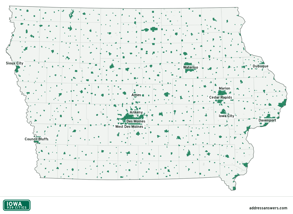
Iowa city limits map image
The map above as a picture: every Iowa city and town in green, with county lines. Boundaries from the Census Bureau, as of January 1, 2025.
You’re welcome to use it in a document or on your own site, with a link back to this page.
Download the map (PNG, 1,200 × 877)Questions about Iowa city limits
How many cities are in Iowa?
Iowa has 939 incorporated places: 939 cities, by the Census Bureau’s boundary files for 2025.
What is the largest city in Iowa?
By population, Des Moines, with about 212,421 residents (2020–2024 American Community Survey 5-year estimates). It is also the largest by land area, at 88.2 square miles.
What is the smallest city in Iowa?
By the Census Bureau’s estimate, Berkley, with 5 residents. Estimates for places this small have a wide margin of error, so treat it as a rough count.
How much of Iowa is unincorporated?
96% of its land and 606,932 of its residents (19%) are outside every city. There, local government is the county. The state also has 87 named unincorporated communities; the largest is Saylorville.
Is Saylorville, IA a city?
No. Saylorville is a census-designated place: a community the Census Bureau maps for statistics, with no city government of its own. About 3,366 people live there, in unincorporated Polk County. An address there is outside city limits, even if its mailing address says otherwise.
Is Park View, IA a city?
No. Park View is a census-designated place: a community the Census Bureau maps for statistics, with no city government of its own. About 2,437 people live there, in unincorporated Scott County. An address there is outside city limits, even if its mailing address says otherwise.
Which cities in Iowa are in more than one county?
62 of the 939 cross a county line, by at least 1% of their land. The largest: Des Moines (Polk and Warren), West Des Moines (Polk, Dallas, Warren, and Madison), and Urbandale (Polk and Dallas). Check an address to see which county it’s in.
Which county in Iowa has the most cities?
Dubuque County, with 21 at least partly inside it. Every county in Iowa has at least one.
Bordering states
More answers for a Iowa address
Each tool checks the same address and puts its own answer first.
- County Census Your county, plus the township or town where those exist. Find your county
- School district Census The public school district that covers the address. Find your school district
- Flood zone FEMA The FEMA zone in plain English, and whether lenders require flood insurance. Check flood zone
- USDA home loans USDA Whether the property is in an area eligible for a USDA Rural Development loan. Check USDA eligibility
- Voting districts Census Your congressional district and your state senate and state house districts. Included in every check
Places, boundaries, land area and counties: US Census Bureau 2025 cartographic boundary files (boundaries as of January 1, 2025). A place is listed in each county that holds at least 1% of its land. Population: 2020–2024 American Community Survey 5-year estimates. Data updated October 24, 2026; page updated October 25, 2026. Boundaries change through annexation; your city or county has the official map.