Maryland city limits map
Maryland has 157 incorporated places: 29 cities, 123 towns, and 5 villages. They cover 4.6% of the state’s land and are home to 25% of its residents. Everyone else lives outside city limits, where local government is the county. Enter an address to see which side of a city line it’s on.
Result for
The map couldn’t load. The answers don’t depend on it.
The boundary couldn’t load. The answer doesn’t depend on it.
Census Geocoder match
More about this address
Sources and limits
- Census
- US Census Bureau Geocoder, current boundaries
- FEMA
- National Flood Hazard Layer, effective flood maps
- USDA
- Rural Development property eligibility
- Map
- Boundaries from Census TIGERweb, flood zones drawn by FEMA, eligible areas from USDA, base map © OpenStreetMap contributors
Census boundaries are updated once a year, so a recent annexation may not show yet. Informational only, not an official determination. Verify with your city or county.
Maryland at a glance
- Incorporated places
- 157
- 29 cities, 123 towns, and 5 villages
- Residents in city limits
- 25%
- 1,560,408 of 6,206,011
- Land in city limits
- 4.6%
- 445.1 of 9,711 sq mi
- Counties
- 24
- 2 with no city or town
- Unincorporated communities
- 379
- Largest: Columbia (104,338)
- Largest city
- Baltimore
- 573,243 residents
How local government works in Maryland
Baltimore is an independent city, separate from Baltimore County around it. Elsewhere, Maryland’s counties provide most local services, and many of its largest communities, such as Columbia, aren’t cities at all.
City limits map for Baltimore
Its own page has the boundary in detail, the communities around it and its school districts.
All 157 cities and towns in Maryland
Every incorporated place, largest first, with the counties it’s in and its size. An address inside one of these is inside city limits; anywhere else in the state is unincorporated.
| Name | Type | County | Population | Land (sq mi) |
|---|---|---|---|---|
| Baltimore | City | Independent city | 573,243 | 80.9 |
| Frederick | City | Frederick | 83,395 | 24.6 |
| Gaithersburg | City | Montgomery | 69,825 | 10.3 |
| Rockville | City | Montgomery | 67,671 | 13.6 |
| Bowie | City | Prince George's | 57,926 | 20.4 |
| Hagerstown | City | Washington | 43,665 | 13.3 |
| Annapolis | City | Anne Arundel | 40,720 | 7.21 |
| College Park | City | Prince George's | 34,540 | 5.62 |
| Salisbury | City | Wicomico | 33,285 | 13.8 |
| Laurel | City | Prince George's | 29,798 | 4.76 |
| Greenbelt | City | Prince George's | 24,678 | 6.24 |
| Hyattsville | City | Prince George's | 20,966 | 2.71 |
| Westminster | City | Carroll | 20,445 | 6.76 |
| Cumberland | City | Allegany | 18,804 | 10.2 |
| Takoma Park | City | Montgomery | 17,632 | 2.09 |
| Easton | Town | Talbot | 17,308 | 11.5 |
| Aberdeen | City | Harford | 17,298 | 6.96 |
| Elkton | Town | Cecil | 15,910 | 9.05 |
| Havre de Grace | City | Harford | 14,994 | 5.94 |
| New Carrollton | City | Prince George's | 13,564 | 1.57 |
| Cambridge | City | Dorchester | 13,152 | 10.6 |
| La Plata | Town | Charles | 10,683 | 7.98 |
| Bel Air | Town | Harford | 10,585 | 3.04 |
| Mount Airy | Town | Carroll, Frederick | 9,805 | 4.14 |
| Bladensburg | Town | Prince George's | 9,583 | 0.99 |
| Brunswick | City | Frederick | 8,450 | 3.27 |
| Mount Rainier | City | Prince George's | 8,245 | 0.64 |
| Taneytown | City | Carroll | 7,932 | 3.36 |
| Riverdale Park | Town | Prince George's | 7,270 | 1.59 |
| Frostburg | City | Allegany | 6,977 | 3.34 |
| Ocean City | Town | Worcester | 6,903 | 4.43 |
| Chesapeake Beach | Town | Calvert | 6,456 | 2.69 |
| Walkersville | Town | Frederick | 6,414 | 4.76 |
| Glenarden | City | Prince George's | 6,344 | 1.19 |
| Thurmont | Town | Frederick | 6,254 | 3.11 |
| Hampstead | Town | Carroll | 6,251 | 3.43 |
| Cheverly | Town | Prince George's | 6,096 | 1.32 |
| District Heights | City | Prince George's | 5,891 | 0.87 |
| Fruitland | City | Wicomico | 5,801 | 3.76 |
| Poolesville | Town | Montgomery | 5,764 | 3.79 |
| Chestertown | Town | Kent | 5,594 | 2.88 |
| Manchester | Town | Carroll | 5,439 | 2.41 |
| Berlin | Town | Worcester | 5,232 | 3.39 |
| Middletown | Town | Frederick | 5,014 | 2.27 |
| Denton | Town | Caroline | 4,936 | 5.27 |
| Leonardtown | Town | St. Mary's | 4,808 | 3.85 |
| Centreville | Town | Queen Anne's | 4,761 | 2.74 |
| Sykesville | Town | Carroll | 4,491 | 1.60 |
| Seat Pleasant | City | Prince George's | 4,489 | 0.81 |
| Perryville | Town | Cecil | 4,447 | 3.23 |
| Pocomoke City | City | Worcester | 4,405 | 3.79 |
| Delmar | Town | Wicomico | 4,261 | 1.68 |
| North East | Town | Cecil | 4,134 | 2.04 |
| Indian Head | Town | Charles | 4,055 | 1.23 |
| Capitol Heights | Town | Prince George's | 4,020 | 0.78 |
| Boonsboro | Town | Washington | 3,809 | 3.07 |
| Brentwood | Town | Prince George's | 3,777 | 0.38 |
| Princess Anne | Town | Somerset | 3,569 | 1.67 |
| Berwyn Heights | Town | Prince George's | 3,318 | 0.70 |
| Smithsburg | Town | Washington | 3,115 | 1.17 |
| Chevy Chase | Town | Montgomery | 2,906 | 0.46 |
| Emmitsburg | Town | Frederick | 2,845 | 1.62 |
| Federalsburg | Town | Caroline | 2,837 | 1.93 |
| Hurlock | Town | Dorchester | 2,819 | 2.67 |
| Rising Sun | Town | Cecil | 2,764 | 1.65 |
| University Park | Town | Prince George's | 2,698 | 0.50 |
| Snow Hill | Town | Worcester | 2,659 | 1.48 |
| Forest Heights | Town | Prince George's | 2,642 | 1.65 |
| Greensboro | Town | Caroline | 2,634 | 1.07 |
| Crisfield | City | Somerset | 2,499 | 1.74 |
| Kensington | Town | Montgomery | 2,369 | 0.50 |
| Myersville | Town | Frederick | 2,358 | 1.28 |
| North Beach | Town | Calvert | 2,296 | 0.33 |
| Oakland | Town | Garrett | 2,254 | 2.71 |
| Mountain Lake Park | Town | Garrett | 2,167 | 1.91 |
| Landover Hills | Town | Prince George's | 2,031 | 0.39 |
| Charlestown | Town | Cecil | 1,999 | 1.17 |
| Pittsville | Town | Wicomico | 1,950 | 1.53 |
| Williamsport | Town | Washington | 1,949 | 0.98 |
| Chevy Chase Village | Town | Montgomery | 1,903 | 0.41 |
| Ridgely | Town | Caroline | 1,772 | 1.86 |
| Hancock | Town | Washington | 1,625 | 2.96 |
| New Market | Town | Frederick | 1,603 | 1.77 |
| Westernport | Town | Allegany | 1,588 | 0.88 |
| Colmar Manor | Town | Prince George's | 1,566 | 0.43 |
| Hebron | Town | Wicomico | 1,566 | 1.31 |
| Woodsboro | Town | Frederick | 1,540 | 0.71 |
| Fairmount Heights | Town | Prince George's | 1,416 | 0.26 |
| New Windsor | Town | Carroll | 1,400 | 0.73 |
| Edmonston | Town | Prince George's | 1,307 | 0.40 |
| Willards | Town | Wicomico | 1,280 | 1.12 |
| St. Michaels | Town | Talbot | 1,240 | 1.17 |
| Rock Hall | Town | Kent | 1,215 | 1.30 |
| Keedysville | Town | Washington | 1,183 | 0.83 |
| Cottage City | Town | Prince George's | 1,158 | 0.27 |
| Somerset | Town | Montgomery | 1,088 | 0.27 |
| Funkstown | Town | Washington | 1,076 | 0.55 |
| Chevy Chase View | Town | Montgomery | 1,063 | 0.26 |
| Church Hill | Town | Queen Anne's | 1,060 | 0.72 |
| Trappe | Town | Talbot | 1,055 | 2.69 |
| Union Bridge | Town | Carroll | 1,055 | 1.13 |
| Grantsville | Town | Garrett | 1,013 | 1.04 |
| Martin's Additions | Village | Montgomery | 1,012 | 0.13 |
| Morningside | Town | Prince George's | 976 | 0.57 |
| Garrett Park | Town | Montgomery | 932 | 0.25 |
| Queenstown | Town | Queen Anne's | 907 | 2.01 |
| Lonaconing | Town | Allegany | 889 | 0.36 |
| Chevy Chase Section Three | Village | Montgomery | 887 | 0.12 |
| Sharptown | Town | Wicomico | 874 | 0.42 |
| Preston | Town | Caroline | 852 | 0.55 |
| Cecilton | Town | Cecil | 820 | 0.48 |
| Chesapeake City | Town | Cecil | 810 | 0.53 |
| Chevy Chase Section Five | Village | Montgomery | 803 | 0.11 |
| North Chevy Chase | Village | Montgomery | 746 | 0.11 |
| Galena | Town | Kent | 728 | 0.37 |
| Oxford | Town | Talbot | 706 | 0.56 |
| Upper Marlboro | Town | Prince George's | 683 | 1.47 |
| Laytonsville | Town | Montgomery | 677 | 1.02 |
| Barton | Town | Allegany | 663 | 0.21 |
| Secretary | Town | Dorchester | 635 | 0.29 |
| North Brentwood | Town | Prince George's | 624 | 0.11 |
| Midland | Town | Allegany | 589 | 0.16 |
| Sharpsburg | Town | Washington | 585 | 0.22 |
| Washington Grove | Town | Montgomery | 577 | 0.34 |
| Mardela Springs | Town | Wicomico | 493 | 0.39 |
| Port Deposit | Town | Cecil | 491 | 2.32 |
| Loch Lynn Heights | Town | Garrett | 480 | 0.32 |
| Millington | Town | Kent, Queen Anne's | 469 | 0.95 |
| Friendsville | Town | Garrett | 416 | 1.00 |
| Betterton | Town | Kent | 391 | 0.99 |
| Vienna | Town | Dorchester | 382 | 0.76 |
| Accident | Town | Garrett | 351 | 0.49 |
| Sudlersville | Town | Queen Anne's | 347 | 1.52 |
| Clear Spring | Town | Washington | 342 | 0.12 |
| Rosemont | Village | Frederick | 310 | 0.56 |
| Deer Park | Town | Garrett | 288 | 1.00 |
| Glen Echo | Town | Montgomery | 276 | 0.13 |
| Kitzmiller | Town | Garrett | 264 | 0.22 |
| Goldsboro | Town | Caroline | 248 | 0.78 |
| East New Market | Town | Dorchester | 246 | 0.40 |
| Barclay | Town | Queen Anne's | 225 | 0.40 |
| Queen Anne | Town | Queen Anne's, Talbot | 210 | 0.14 |
| Barnesville | Town | Montgomery | 208 | 0.47 |
| Brookeville | Town | Montgomery | 161 | 0.13 |
| Marydel | Town | Caroline | 149 | 0.12 |
| Burkittsville | Town | Frederick | 135 | 0.45 |
| Church Creek | Town | Dorchester | 135 | 0.34 |
| Henderson | Town | Caroline | 132 | 0.13 |
| Hillsboro | Town | Caroline | 127 | 0.14 |
| Galestown | Town | Dorchester | 114 | 0.23 |
| Highland Beach | Town | Anne Arundel | 107 | 0.06 |
| Luke | Town | Allegany | 89 | 0.27 |
| Eagle Harbor | Town | Prince George's | 72 | 0.13 |
| Templeville | Town | Caroline, Queen Anne's | 63 | 0.05 |
| Brookview | Town | Dorchester | 33 | 0.04 |
| Eldorado | Town | Dorchester | 30 | 0.07 |
| Port Tobacco Village | Town | Charles | 4 | 0.18 |
Showing 1–50 of 157
Unincorporated communities in Maryland
Census-designated places: named communities the Census Bureau maps for statistics, with no city government of their own. An address in one is outside city limits, even when its mailing address names a city. Maryland has 379.
| Community | County | Population | Land (sq mi) |
|---|---|---|---|
| Columbia | Howard | 104,338 | 31.9 |
| Germantown | Montgomery | 90,719 | 17.0 |
| Waldorf | Charles | 82,943 | 36.2 |
| Silver Spring | Montgomery | 81,462 | 7.88 |
| Ellicott City | Howard | 75,257 | 30.0 |
| Glen Burnie | Anne Arundel | 72,590 | 17.3 |
| Bethesda | Montgomery | 69,397 | 13.3 |
| Dundalk | Baltimore | 65,969 | 13.1 |
| Towson | Baltimore | 58,679 | 14.2 |
| Severn | Anne Arundel | 58,402 | 18.3 |
| Bel Air South | Harford | 58,137 | 21.3 |
| Aspen Hill | Montgomery | 53,279 | 9.51 |
| Wheaton | Montgomery | 52,926 | 6.90 |
| North Bethesda | Montgomery | 49,677 | 8.88 |
| Potomac | Montgomery | 45,902 | 25.2 |
| Odenton | Anne Arundel | 45,002 | 14.8 |
| Catonsville | Baltimore | 43,368 | 14.0 |
| Essex | Baltimore | 40,580 | 9.26 |
| Woodlawn | Baltimore | 40,379 | 9.54 |
| Severna Park | Anne Arundel | 40,228 | 16.5 |
| Clinton | Prince George's | 38,376 | 25.0 |
| Owings Mills | Baltimore | 37,245 | 9.53 |
| Randallstown | Baltimore | 35,957 | 10.2 |
| Olney | Montgomery | 35,797 | 16.2 |
| Chillum | Prince George's | 34,871 | 3.38 |
| Pasadena | Anne Arundel | 34,309 | 14.9 |
| Montgomery Village | Montgomery | 34,110 | 3.88 |
| Pikesville | Baltimore | 33,524 | 12.3 |
| Middle River | Baltimore | 31,712 | 12.8 |
| Eldersburg | Carroll | 31,695 | 39.8 |
| Bel Air North | Harford | 31,302 | 16.0 |
| Milford Mill | Baltimore | 30,829 | 6.94 |
| Parkville | Baltimore | 30,549 | 4.28 |
| Clarksburg | Montgomery | 30,487 | 9.64 |
| Crofton | Anne Arundel | 29,549 | 6.61 |
| South Laurel | Prince George's | 29,272 | 8.07 |
| Perry Hall | Baltimore | 29,105 | 6.94 |
| Ilchester | Howard | 28,364 | 10.8 |
| Carney | Baltimore | 28,343 | 7.01 |
| Lochearn | Baltimore | 27,074 | 5.59 |
| Ballenger Creek | Frederick | 26,390 | 10.8 |
| Elkridge | Howard | 26,283 | 8.36 |
| Fairland | Montgomery | 26,231 | 4.97 |
| Reisterstown | Baltimore | 25,582 | 5.09 |
| North Laurel | Howard | 25,563 | 6.48 |
| Fort Washington | Prince George's | 25,134 | 13.8 |
| Edgewood | Harford | 24,922 | 17.1 |
| Landover | Prince George's | 24,514 | 4.00 |
| Arnold | Anne Arundel | 24,303 | 10.8 |
| Cockeysville | Baltimore | 23,962 | 12.0 |
| North Potomac | Montgomery | 23,922 | 6.52 |
| Suitland | Prince George's | 23,793 | 4.25 |
| Camp Springs | Prince George's | 22,544 | 7.68 |
| Arbutus | Baltimore | 22,507 | 6.53 |
| Langley Park | Prince George's | 21,508 | 0.99 |
| Rosedale | Baltimore | 20,002 | 6.86 |
| Maryland City | Anne Arundel | 19,186 | 7.72 |
| Beltsville | Prince George's | 19,176 | 7.21 |
| Redland | Montgomery | 18,665 | 7.18 |
| East Riverdale | Prince George's | 18,336 | 1.61 |
| Seabrook | Prince George's | 18,317 | 3.07 |
| Lake Shore | Anne Arundel | 18,249 | 13.4 |
| Oxon Hill | Prince George's | 17,893 | 6.44 |
| Damascus | Montgomery | 17,640 | 14.2 |
| Calverton | Montgomery | 17,624 | 4.58 |
| Ferndale | Anne Arundel | 17,529 | 3.96 |
| Adelphi | Prince George's | 17,395 | 2.72 |
| White Oak | Montgomery | 17,329 | 3.12 |
| Parole | Anne Arundel | 17,229 | 10.3 |
| Glenmont | Montgomery | 17,208 | 2.80 |
| Glassmanor | Prince George's | 16,981 | 2.31 |
| Cloverly | Montgomery | 16,646 | 10.1 |
| Brooklyn Park | Anne Arundel | 16,067 | 4.21 |
| Mays Chapel | Baltimore | 16,066 | 4.48 |
| Hillcrest Heights | Prince George's | 16,063 | 2.49 |
| Rossville | Baltimore | 16,059 | 5.38 |
| Bensville | Charles | 15,848 | 16.9 |
| Summerfield | Prince George's | 15,065 | 3.63 |
| Colesville | Montgomery | 14,519 | 5.12 |
| Linganore | Frederick | 14,444 | 8.28 |
| Accokeek | Prince George's | 14,362 | 27.4 |
| Lake Arbor | Prince George's | 14,335 | 4.00 |
| Urbana | Frederick | 14,260 | 7.77 |
| Joppatowne | Harford | 14,237 | 6.73 |
| Kettering | Prince George's | 14,014 | 5.49 |
| Flower Hill | Montgomery | 13,794 | 2.09 |
| Glenn Dale | Prince George's | 13,772 | 7.15 |
| Brock Hall | Prince George's | 13,615 | 9.61 |
| Green Valley | Frederick | 13,602 | 17.1 |
| Lexington Park | St. Mary's | 13,252 | 6.06 |
| Westphalia | Prince George's | 13,228 | 9.91 |
| California | St. Mary's | 13,136 | 12.9 |
| Kemp Mill | Montgomery | 13,042 | 2.51 |
| Overlea | Baltimore | 13,035 | 3.02 |
| Rosaryville | Prince George's | 12,883 | 9.18 |
| Ocean Pines | Worcester | 12,351 | 6.47 |
| Honeygo | Baltimore | 12,250 | 5.85 |
| Largo | Prince George's | 12,229 | 3.06 |
| Riviera Beach | Anne Arundel | 12,192 | 2.63 |
| Brandywine | Prince George's | 12,160 | 21.0 |
| Annapolis Neck | Anne Arundel | 12,032 | 6.93 |
| Travilah | Montgomery | 11,721 | 15.9 |
| Lanham | Prince George's | 11,433 | 3.53 |
| Mitchellville | Prince George's | 11,359 | 4.94 |
| Linthicum | Anne Arundel | 11,313 | 5.46 |
| Fort Meade | Anne Arundel | 11,225 | 8.08 |
| Friendly | Prince George's | 11,119 | 4.88 |
| White Marsh | Baltimore | 10,932 | 5.31 |
| Walker Mill | Prince George's | 10,931 | 3.00 |
| Halfway | Washington | 10,849 | 4.37 |
| Scaggsville | Howard | 10,564 | 5.04 |
| Forestville | Prince George's | 10,495 | 3.93 |
| Timonium | Baltimore | 10,304 | 5.72 |
| Marlton | Prince George's | 10,222 | 5.93 |
| Burtonsville | Montgomery | 10,203 | 7.84 |
| Fallston | Harford | 10,013 | 14.0 |
| Jessup | Anne Arundel | 9,931 | 6.05 |
| Coral Hills | Prince George's | 9,756 | 1.63 |
| Garrison | Baltimore | 9,469 | 3.16 |
| Chevy Chase | Montgomery | 9,445 | 2.42 |
| Marlboro Village | Prince George's | 9,382 | 3.45 |
| Bryans Road | Charles | 9,371 | 15.4 |
| Chesapeake Ranch Estates | Calvert | 9,241 | 4.32 |
| Cape St. Claire | Anne Arundel | 9,236 | 2.00 |
| Edgemere | Baltimore | 9,061 | 10.9 |
| Temple Hills | Prince George's | 8,969 | 1.41 |
| North Kensington | Montgomery | 8,954 | 1.50 |
| Leisure World | Montgomery | 8,882 | 1.13 |
| Stevensville | Queen Anne's | 8,802 | 6.43 |
| Mayo | Anne Arundel | 8,694 | 5.62 |
| Edgewater | Anne Arundel | 8,519 | 2.99 |
| Savage | Howard | 8,239 | 2.74 |
| Baltimore Highlands | Baltimore | 8,206 | 1.73 |
| Four Corners | Montgomery | 8,150 | 1.46 |
| South Kensington | Montgomery | 8,148 | 2.10 |
| Robinwood | Washington | 8,042 | 3.81 |
| Lansdowne | Baltimore | 7,876 | 2.28 |
| Woodlawn | Prince George's | 7,750 | 1.14 |
| Wildewood | St. Mary's | 7,552 | 2.85 |
| Fairwood | Prince George's | 7,526 | 3.41 |
| Darnestown | Montgomery | 7,051 | 16.4 |
| Bowleys Quarters | Baltimore | 7,006 | 3.15 |
| Forest Glen | Montgomery | 6,840 | 1.00 |
| Riverside | Harford | 6,585 | 2.61 |
| Lutherville | Baltimore | 6,574 | 2.11 |
| Fountainhead-Orchard Hills | Washington | 6,567 | 4.42 |
| Spring Ridge | Frederick | 5,922 | 2.69 |
| Fulton | Howard | 5,677 | 3.79 |
| Ashton-Sandy Spring | Montgomery | 5,630 | 10.3 |
| Layhill | Montgomery | 5,497 | 1.59 |
| Marlow Heights | Prince George's | 5,456 | 2.03 |
| Hampton | Baltimore | 5,372 | 5.95 |
| Deale | Anne Arundel | 5,333 | 5.31 |
| Peppermill Village | Prince George's | 5,238 | 0.74 |
| Springdale | Prince George's | 5,226 | 1.33 |
| West Ocean City | Worcester | 5,198 | 4.19 |
| Silver Hill | Prince George's | 5,193 | 1.34 |
| Cresaptown | Allegany | 5,121 | 2.66 |
| Hillandale | Montgomery | 5,060 | 1.89 |
| Abingdon | Harford | 5,019 | 2.76 |
| Riva | Anne Arundel | 4,976 | 2.46 |
| St. James | Washington | 4,824 | 6.05 |
| Chester | Queen Anne's | 4,797 | 5.24 |
| Shady Side | Anne Arundel | 4,727 | 6.65 |
| Kingsville | Baltimore | 4,687 | 10.0 |
| Woodmore | Prince George's | 4,613 | 6.55 |
| National Harbor | Prince George's | 4,454 | 1.26 |
| West Laurel | Prince George's | 4,428 | 2.26 |
| La Vale | Allegany | 4,196 | 9.11 |
| Friendship Heights Village | Montgomery | 4,002 | 0.06 |
| Marlboro Meadows | Prince George's | 3,929 | 6.09 |
| Pleasant Hills | Harford | 3,836 | 4.36 |
| Golden Beach | St. Mary's | 3,830 | 3.79 |
| Burnt Mills | Montgomery | 3,751 | 0.83 |
| Brookmont | Montgomery | 3,671 | 1.31 |
| Konterra | Prince George's | 3,641 | 6.07 |
| Maugansville | Washington | 3,624 | 2.45 |
| Drum Point | Calvert | 3,589 | 1.66 |
| Monrovia | Frederick | 3,568 | 2.25 |
| Grasonville | Queen Anne's | 3,564 | 5.53 |
| Brown Station | Prince George's | 3,451 | 6.17 |
| Melwood | Prince George's | 3,401 | 2.83 |
| Jefferson | Frederick | 3,314 | 2.79 |
| Bartonsville | Frederick | 3,282 | 2.14 |
| Andrews AFB | Prince George's | 3,130 | 6.93 |
| Naval Academy | Anne Arundel | 3,006 | 0.53 |
| Prince Frederick | Calvert | 2,955 | 3.66 |
| Braddock Heights | Frederick | 2,892 | 5.34 |
| Gambrills | Anne Arundel | 2,830 | 7.55 |
| Huntingtown | Calvert | 2,689 | 8.07 |
| Owings | Calvert | 2,643 | 3.94 |
| Lusby | Calvert | 2,595 | 3.51 |
| Paramount-Long Meadow | Washington | 2,569 | 2.18 |
| Jarrettsville | Harford | 2,560 | 8.64 |
| Point of Rocks | Frederick | 2,462 | 1.12 |
| Solomons | Calvert | 2,440 | 1.99 |
| Herald Harbor | Anne Arundel | 2,430 | 1.68 |
| Croom | Prince George's | 2,418 | 34.2 |
| Baden | Prince George's | 2,325 | 27.6 |
| Cedar Heights | Prince George's | 2,213 | 0.22 |
| Aberdeen Proving Ground | Harford | 2,193 | 11.1 |
| Cabin John | Montgomery | 2,179 | 1.20 |
| Perryman | Harford | 2,174 | 5.45 |
| Queensland | Prince George's | 2,168 | 4.69 |
| Dunkirk | Calvert | 2,166 | 6.59 |
| Hughesville | Charles | 2,098 | 11.2 |
| Romancoke | Queen Anne's | 2,064 | 1.27 |
| Adamstown | Frederick | 2,025 | 1.06 |
| Derwood | Montgomery | 1,984 | 0.63 |
| Long Beach | Calvert | 1,849 | 1.67 |
| Bel Air | Allegany | 1,837 | 0.69 |
| Arden on the Severn | Anne Arundel | 1,761 | 1.43 |
| Crownsville | Anne Arundel | 1,756 | 5.09 |
| Kingstown | Queen Anne's | 1,713 | 2.27 |
| Wilson-Conococheague | Washington | 1,663 | 4.72 |
| Queen Anne | Prince George's | 1,443 | 8.71 |
| Mechanicsville | St. Mary's | 1,395 | 5.19 |
| Potomac Heights | Charles | 1,351 | 1.07 |
| Libertytown | Frederick | 1,346 | 2.41 |
| Piney Point | St. Mary's | 1,274 | 1.50 |
| Buckeystown | Frederick | 1,192 | 0.91 |
| Ten Mile Creek | Montgomery | 1,184 | 5.80 |
| Charlotte Hall | St. Mary's | 1,172 | 5.06 |
| Bowmans Addition | Allegany | 1,102 | 1.12 |
| Highfield-Cascade | Washington | 1,089 | 1.73 |
| Algonquin | Dorchester | 1,074 | 0.75 |
| Calvert Beach | Calvert | 1,074 | 0.82 |
| Mount Vernon | Somerset | 1,067 | 13.0 |
| Galesville | Anne Arundel | 1,062 | 1.32 |
| Eden | Somerset | 1,053 | 5.59 |
| Spencerville | Montgomery | 1,028 | 1.56 |
| Potomac Park | Allegany | 978 | 0.39 |
| Highland | Howard | 972 | 2.41 |
| Bowling Green | Allegany | 966 | 0.96 |
| Downsville | Washington | 958 | 0.62 |
| Pylesville | Harford | 933 | 4.74 |
| Callaway | St. Mary's | 930 | 4.76 |
| Cobb Island | Charles | 916 | 0.63 |
| Cavetown | Washington | 858 | 1.90 |
| Maryland Park | Prince George's | 839 | 0.17 |
| Pomfret | Charles | 747 | 2.74 |
| Tilghman Island | Talbot | 741 | 2.40 |
| Finzel | Garrett | 740 | 3.94 |
| Cedarville | Prince George's | 730 | 13.3 |
| St. Leonard | Calvert | 726 | 2.29 |
| Aquasco | Prince George's | 719 | 19.8 |
| Eckhart Mines | Allegany | 670 | 1.52 |
| Mount Aetna | Washington | 637 | 1.41 |
| Corriganville | Allegany | 622 | 0.36 |
| Sabillasville | Frederick | 556 | 1.67 |
| West Pocomoke | Somerset | 548 | 9.41 |
| Grahamtown | Allegany | 537 | 0.15 |
| Bishopville | Worcester | 516 | 2.86 |
| Ellerslie | Allegany | 514 | 0.92 |
| Mount Savage | Allegany | 514 | 0.96 |
| Butlertown | Kent | 511 | 0.82 |
| Fairplay | Washington | 511 | 1.20 |
| Chesapeake Landing | Kent | 509 | 1.00 |
| Kent Narrows | Queen Anne's | 507 | 0.94 |
| Leitersburg | Washington | 498 | 1.75 |
| Rawlings | Allegany | 476 | 0.89 |
| Broomes Island | Calvert | 460 | 0.73 |
| Cordova | Talbot | 448 | 4.87 |
| Fairmount | Somerset | 440 | 12.3 |
| Beaver Creek | Washington | 439 | 1.15 |
| Nanticoke | Wicomico | 434 | 2.63 |
| Pinesburg | Washington | 409 | 0.73 |
| Mount Lena | Washington | 391 | 1.25 |
| Tall Timbers | St. Mary's | 391 | 1.35 |
| Williston | Caroline | 391 | 0.26 |
| Tolchester | Kent | 379 | 0.61 |
| Midlothian | Allegany | 377 | 0.69 |
| Franklin | Allegany | 373 | 0.28 |
| McCoole | Allegany | 373 | 1.40 |
| Mapleville | Washington | 365 | 0.40 |
| Lewistown | Frederick | 362 | 0.64 |
| Darlington | Harford | 353 | 1.05 |
| Smith Island | Somerset | 345 | 4.35 |
| Danville | Allegany | 341 | 1.14 |
| Deal Island | Somerset | 341 | 3.03 |
| Bryantown | Charles | 325 | 4.14 |
| Chewsville | Washington | 314 | 0.84 |
| Greensburg | Washington | 314 | 0.40 |
| Bagtown | Washington | 310 | 0.55 |
| San Mar | Washington | 306 | 0.47 |
| Zihlman | Allegany | 306 | 1.51 |
| Fairlee | Kent | 299 | 3.79 |
| Gilmore | Allegany | 288 | 0.10 |
| Shaft | Allegany | 285 | 0.79 |
| Tilghmanton | Washington | 282 | 0.46 |
| Friendship | Anne Arundel | 278 | 1.80 |
| St. George Island | St. Mary's | 277 | 0.79 |
| Pleasant Grove | Allegany | 252 | 1.60 |
| Crumpton | Queen Anne's | 248 | 0.94 |
| Garretts Mill | Washington | 244 | 0.57 |
| Newark | Worcester | 244 | 9.44 |
| Rock Point | Charles | 244 | 0.63 |
| Chance | Somerset | 230 | 1.67 |
| Powellville | Wicomico | 230 | 1.57 |
| Dames Quarter | Somerset | 226 | 11.9 |
| Mercersville | Washington | 220 | 0.32 |
| Trego-Rohrersville Station | Washington | 209 | 0.43 |
| Fishing Creek | Dorchester | 207 | 1.06 |
| Kennedyville | Kent | 205 | 0.51 |
| Mount Briar | Washington | 201 | 0.62 |
| Whaleyville | Worcester | 198 | 1.01 |
| Nikep | Allegany | 194 | 0.15 |
| Choptank | Caroline | 186 | 0.24 |
| Dawson | Allegany | 180 | 0.61 |
| Pecktonville | Washington | 179 | 0.59 |
| Moscow | Allegany | 176 | 0.25 |
| Bivalve | Wicomico | 175 | 1.45 |
| Parsonsburg | Wicomico | 166 | 1.31 |
| Crellin | Garrett | 165 | 0.70 |
| Sandy Hook | Washington | 165 | 0.22 |
| Hutton | Garrett | 157 | 0.16 |
| Tyaskin | Wicomico | 155 | 1.42 |
| Ringgold | Washington | 153 | 0.29 |
| Bloomington | Garrett | 150 | 0.62 |
| Benedict | Charles | 148 | 0.23 |
| Breathedsville | Washington | 147 | 0.37 |
| Nanticoke Acres | Wicomico | 142 | 0.26 |
| Rohrersville | Washington | 141 | 0.35 |
| Dargan | Washington | 135 | 0.30 |
| Madison | Dorchester | 133 | 3.20 |
| Taylors Island | Dorchester | 127 | 4.14 |
| Lisbon | Howard | 126 | 1.48 |
| Quantico | Wicomico | 126 | 2.11 |
| Worton | Kent | 126 | 0.92 |
| Graceham | Frederick | 121 | 0.48 |
| Reid | Washington | 120 | 0.13 |
| Bier | Allegany | 118 | 1.46 |
| Detmold | Allegany | 116 | 0.16 |
| Oldtown | Allegany | 112 | 0.37 |
| Stockton | Worcester | 110 | 1.70 |
| Edgemont | Washington | 107 | 0.53 |
| Pondsville | Washington | 102 | 0.31 |
| Still Pond | Kent | 102 | 0.19 |
| Gorman | Garrett | 100 | 1.25 |
| Jugtown | Washington | 97 | 0.33 |
| Vale Summit | Allegany | 92 | 0.99 |
| Cearfoss | Washington | 86 | 0.20 |
| Yarrowsburg | Washington | 83 | 0.23 |
| Whitehaven | Wicomico | 80 | 0.37 |
| Girdletree | Worcester | 77 | 0.68 |
| Barrelville | Allegany | 71 | 0.04 |
| Little Orleans | Allegany | 68 | 1.24 |
| National | Allegany | 64 | 0.16 |
| Indian Springs | Washington | 61 | 0.12 |
| Allen | Wicomico | 55 | 0.43 |
| Klondike | Allegany | 54 | 0.39 |
| Frenchtown-Rumbly | Somerset | 52 | 3.76 |
| Antietam | Washington | 50 | 0.15 |
| Kemps Mill | Washington | 49 | 0.26 |
| Spring Gap | Allegany | 49 | 0.65 |
| West Denton | Caroline | 48 | 0.29 |
| Carlos | Allegany | 43 | 0.29 |
| Jesterville | Wicomico | 42 | 1.59 |
| Woodland | Allegany | 42 | 0.20 |
| Big Pool | Washington | 41 | 0.11 |
| Edesville | Kent | 34 | 0.28 |
| Gapland | Washington | 26 | 0.22 |
| Big Spring | Washington | 21 | 0.14 |
| Brownsville | Washington | 20 | 0.28 |
| Ocean | Allegany | 18 | 0.04 |
| Jennings | Garrett | 16 | 0.33 |
| Clarysville | Allegany | 13 | 0.12 |
| Elliott | Dorchester | 10 | 0.35 |
| Flintstone | Allegany | 8 | 0.41 |
| Georgetown | Kent | 8 | 1.47 |
| Bakersville | Washington | 0 | 0.05 |
| Charlton | Washington | 0 | 0.16 |
| Eakles Mill | Washington | 0 | 0.08 |
| Ernstville | Washington | 0 | 0.15 |
| Fairview | Washington | 0 | 0.21 |
| Fort Ritchie | Washington | 0 | 0.97 |
| Middleburg | Washington | 0 | 0.10 |
| Swanton | Garrett | 0 | 0.38 |
| Waterview | Wicomico | 0 | 0.49 |
Showing 1–50 of 379
Counties in Maryland
24 counties, with how many cities and towns have land in each and the largest whose main county it is.
| County | Cities | Largest | Population | Land (sq mi) |
|---|---|---|---|---|
| Montgomery County | 19 | Gaithersburg | 1,065,949 | 493.1 |
| Prince George's County | 27 | Bowie | 959,754 | 482.6 |
| Baltimore County | 0 | None | 850,796 | 598.4 |
| Anne Arundel County | 2 | Annapolis | 598,166 | 414.8 |
| Baltimore city | 1 | Baltimore | 573,243 | 80.9 |
| Howard County | 0 | None | 336,328 | 250.9 |
| Frederick County | 12 | Frederick | 287,048 | 660.6 |
| Harford County | 3 | Aberdeen | 263,757 | 437.1 |
| Carroll County | 8 | Westminster | 175,321 | 447.6 |
| Charles County | 3 | La Plata | 170,527 | 457.8 |
| Washington County | 9 | Hagerstown | 155,709 | 457.8 |
| St. Mary's County | 1 | Leonardtown | 115,126 | 358.6 |
| Cecil County | 8 | Elkton | 104,960 | 346.3 |
| Wicomico County | 8 | Salisbury | 104,914 | 374.4 |
| Calvert County | 2 | Chesapeake Beach | 94,313 | 213.2 |
| Allegany County | 7 | Cumberland | 67,452 | 422.2 |
| Worcester County | 4 | Ocean City | 53,700 | 468.3 |
| Queen Anne's County | 8 | Centreville | 51,825 | 371.7 |
| Talbot County | 5 | Easton | 37,917 | 268.6 |
| Caroline County | 10 | Denton | 33,669 | 319.4 |
| Dorchester County | 9 | Cambridge | 32,754 | 540.8 |
| Garrett County | 8 | Oakland | 28,615 | 649.1 |
| Somerset County | 2 | Princess Anne | 24,822 | 319.7 |
| Kent County | 5 | Chestertown | 19,346 | 276.9 |
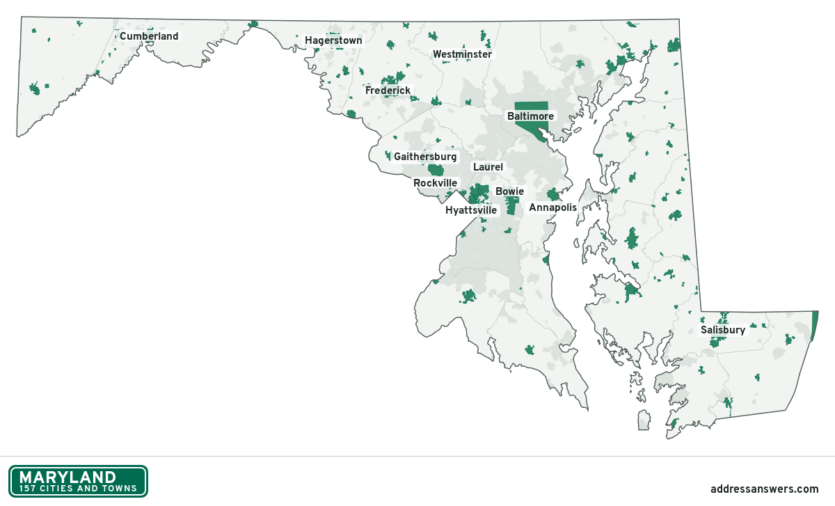
Maryland city limits map image
The map above as a picture: every Maryland city and town in green, with county lines. Boundaries from the Census Bureau, as of January 1, 2025.
You’re welcome to use it in a document or on your own site, with a link back to this page.
Download the map (PNG, 1,200 × 727)Questions about Maryland city limits
How many cities and towns are in Maryland?
Maryland has 157 incorporated places: 29 cities, 123 towns, and 5 villages, by the Census Bureau’s boundary files for 2025.
What is the largest city in Maryland?
By population, Baltimore, with about 573,243 residents (2020–2024 American Community Survey 5-year estimates). It is also the largest by land area, at 80.9 square miles.
What is the smallest town in Maryland?
By the Census Bureau’s estimate, Port Tobacco Village, with 4 residents. Estimates for places this small have a wide margin of error, so treat it as a rough count.
How much of Maryland is unincorporated?
95% of its land and 4.6 million of its residents (75%) are outside every city or town. There, local government is the county. The state also has 379 named unincorporated communities; the largest is Columbia.
Is Columbia, MD a city?
No. Columbia is a census-designated place: a community the Census Bureau maps for statistics, with no city government of its own. About 104,338 people live there, in unincorporated Howard County. An address there is outside city limits, even if its mailing address says otherwise.
Is Germantown, MD a city?
No. Germantown is a census-designated place: a community the Census Bureau maps for statistics, with no city government of its own. About 90,719 people live there, in unincorporated Montgomery County. An address there is outside city limits, even if its mailing address says otherwise.
Which cities and towns in Maryland are in more than one county?
Four of the 157 cross a county line, by at least 1% of their land. The largest: Mount Airy (Carroll and Frederick), Millington (Kent and Queen Anne's), and Queen Anne (Queen Anne's and Talbot). Check an address to see which county it’s in.
Which county in Maryland has the most cities and towns?
Prince George's County, with 27 at least partly inside it. Baltimore County and Howard County have none.
Bordering states
More answers for a Maryland address
Each tool checks the same address and puts its own answer first.
- County Census Your county, plus the township or town where those exist. Find your county
- School district Census The public school district that covers the address. Find your school district
- Flood zone FEMA The FEMA zone in plain English, and whether lenders require flood insurance. Check flood zone
- USDA home loans USDA Whether the property is in an area eligible for a USDA Rural Development loan. Check USDA eligibility
- Voting districts Census Your congressional district and your state senate and state house districts. Included in every check
Places, boundaries, land area and counties: US Census Bureau 2025 cartographic boundary files (boundaries as of January 1, 2025). A place is listed in each county that holds at least 1% of its land. Population: 2020–2024 American Community Survey 5-year estimates. Data updated October 24, 2026; page updated October 25, 2026. Boundaries change through annexation; your city or county has the official map.