Wisconsin city limits map
Wisconsin has 608 incorporated places: 190 cities and 418 villages. They cover 6.2% of the state’s land and are home to 73% of its residents. Everyone else lives outside city limits, where local government is the town and the county. Enter an address to see which side of a city line it’s on.
Result for
The map couldn’t load. The answers don’t depend on it.
The boundary couldn’t load. The answer doesn’t depend on it.
Census Geocoder match
More about this address
Sources and limits
- Census
- US Census Bureau Geocoder, current boundaries
- FEMA
- National Flood Hazard Layer, effective flood maps
- USDA
- Rural Development property eligibility
- Map
- Boundaries from Census TIGERweb, flood zones drawn by FEMA, eligible areas from USDA, base map © OpenStreetMap contributors
Census boundaries are updated once a year, so a recent annexation may not show yet. Informational only, not an official determination. Verify with your city or county.
Wisconsin at a glance
- Incorporated places
- 608
- 190 cities and 418 villages
- Residents in city limits
- 73%
- 4,335,649 of 5,914,872
- Land in city limits
- 6.2%
- 3,377 of 54,168 sq mi
- Counties
- 72
- 2 with no city or village
- Unincorporated communities
- 200
- Largest: Lake Wisconsin (5,384)
- Largest city
- Milwaukee
- 566,973 residents
How local government works in Wisconsin
Outside its 190 cities and 418 villages, Wisconsin is divided into 1,242 towns. A Wisconsin town isn’t a city: it’s a rural unit of government with an elected town board, and an address in a town is outside city limits.
City limits maps for 3 Wisconsin cities
Every Wisconsin city with 100,000 or more residents has its own page: the boundary in detail, the places around it and its school districts.
All 608 cities and villages in Wisconsin
Every incorporated place, largest first, with the counties it’s in and its size. An address inside one of these is inside city limits; anywhere else in the state is unincorporated.
| Name | Type | County | Population | Land (sq mi) |
|---|---|---|---|---|
| Milwaukee | City | Milwaukee | 566,973 | 96.2 |
| Madison | City | Dane | 278,001 | 84.2 |
| Green Bay | City | Brown | 106,253 | 45.5 |
| Kenosha | City | Kenosha | 99,372 | 29.6 |
| Racine | City | Racine | 77,633 | 15.5 |
| Appleton | City | Outagamie, Calumet +1 | 75,023 | 25.4 |
| Waukesha | City | Waukesha | 71,233 | 25.5 |
| Eau Claire | City | Eau Claire, Chippewa | 70,322 | 34.4 |
| Oshkosh | City | Winnebago | 66,729 | 27.8 |
| Janesville | City | Rock | 66,030 | 34.6 |
| West Allis | City | Milwaukee | 59,612 | 11.4 |
| La Crosse | City | La Crosse | 51,356 | 21.7 |
| Sheboygan | City | Sheboygan | 49,645 | 16.2 |
| Wauwatosa | City | Milwaukee | 48,529 | 13.2 |
| Fond du Lac | City | Fond du Lac | 44,494 | 19.2 |
| Brookfield | City | Waukesha | 41,273 | 27.4 |
| New Berlin | City | Waukesha | 40,270 | 36.4 |
| Wausau | City | Marathon | 39,996 | 19.2 |
| Menomonee Falls | Village | Waukesha | 39,539 | 32.9 |
| Sun Prairie | City | Dane | 37,570 | 13.1 |
| Greenfield | City | Milwaukee | 37,345 | 11.5 |
| Oak Creek | City | Milwaukee | 37,325 | 28.4 |
| Beloit | City | Rock | 36,534 | 17.4 |
| Franklin | City | Milwaukee | 35,886 | 34.6 |
| Manitowoc | City | Manitowoc | 34,620 | 18.0 |
| Fitchburg | City | Dane | 32,619 | 35.2 |
| West Bend | City | Washington | 32,030 | 15.7 |
| Mount Pleasant | Village | Racine | 27,953 | 33.9 |
| Neenah | City | Winnebago | 27,336 | 9.67 |
| Superior | City | Douglas | 26,677 | 36.6 |
| Stevens Point | City | Portage | 25,785 | 17.5 |
| Muskego | City | Waukesha | 25,406 | 31.6 |
| De Pere | City | Brown | 25,301 | 12.0 |
| Mequon | City | Ozaukee | 25,270 | 46.3 |
| Caledonia | Village | Racine | 25,257 | 45.2 |
| Watertown | City | Jefferson, Dodge | 22,774 | 12.2 |
| Middleton | City | Dane | 22,301 | 9.52 |
| Pleasant Prairie | Village | Kenosha | 21,669 | 33.4 |
| Howard | Village | Brown | 21,087 | 18.7 |
| Germantown | Village | Washington | 20,962 | 34.4 |
| South Milwaukee | City | Milwaukee | 20,442 | 4.83 |
| Onalaska | City | La Crosse | 19,348 | 10.6 |
| Fox Crossing | Village | Winnebago | 19,131 | 12.6 |
| Oconomowoc | City | Waukesha | 19,080 | 11.8 |
| Wisconsin Rapids | City | Wood | 18,722 | 13.9 |
| Marshfield | City | Wood, Marathon | 18,700 | 13.8 |
| Menasha | City | Winnebago, Calumet | 18,273 | 6.04 |
| Cudahy | City | Milwaukee | 17,853 | 4.77 |
| Kaukauna | City | Outagamie | 17,706 | 8.27 |
| Ashwaubenon | Village | Brown | 17,314 | 12.4 |
| River Falls | City | Pierce, St. Croix | 16,719 | 7.46 |
| Beaver Dam | City | Dodge | 16,565 | 8.80 |
| Menomonie | City | Dunn | 16,539 | 13.8 |
| Bellevue | Village | Brown | 16,442 | 14.4 |
| Pewaukee | City | Waukesha | 16,211 | 19.5 |
| Hartford | City | Washington, Dodge | 15,821 | 9.05 |
| Whitewater | City | Walworth, Jefferson | 15,807 | 8.84 |
| Weston | Village | Marathon | 15,749 | 21.7 |
| Waunakee | Village | Dane | 15,687 | 7.40 |
| Verona | City | Dane | 15,232 | 8.28 |
| Hudson | City | St. Croix | 14,959 | 6.82 |
| Chippewa Falls | City | Chippewa | 14,782 | 11.4 |
| Whitefish Bay | Village | Milwaukee | 14,665 | 2.12 |
| Greendale | Village | Milwaukee | 14,594 | 5.57 |
| Salem Lakes | Village | Kenosha | 14,366 | 30.4 |
| Allouez | Village | Brown | 13,975 | 4.57 |
| Plover | Village | Portage | 13,884 | 10.7 |
| Harrison | Village | Calumet | 13,658 | 31.9 |
| Glendale | City | Milwaukee | 13,656 | 5.76 |
| Shorewood | Village | Milwaukee | 13,627 | 1.59 |
| Stoughton | City | Dane | 13,033 | 6.16 |
| Greenville | Village | Outagamie | 12,987 | 35.7 |
| Suamico | Village | Brown | 12,985 | 36.3 |
| Baraboo | City | Sauk | 12,769 | 7.56 |
| Port Washington | City | Ozaukee | 12,645 | 5.96 |
| Cedarburg | City | Ozaukee | 12,605 | 4.92 |
| Brown Deer | Village | Milwaukee | 12,564 | 4.40 |
| Fort Atkinson | City | Jefferson | 12,463 | 5.85 |
| Grafton | Village | Ozaukee | 12,445 | 5.33 |
| Sussex | Village | Waukesha | 12,066 | 8.45 |
| Richfield | Village | Washington | 11,755 | 35.9 |
| Little Chute | Village | Outagamie | 11,754 | 6.45 |
| Oregon | Village | Dane | 11,547 | 4.56 |
| DeForest | Village | Dane | 11,501 | 9.50 |
| Platteville | City | Grant | 11,499 | 6.18 |
| Holmen | Village | La Crosse | 11,372 | 7.87 |
| Two Rivers | City | Manitowoc | 11,231 | 6.06 |
| Waupun | City | Dodge, Fond du Lac | 11,174 | 4.69 |
| Marinette | City | Marinette | 11,115 | 7.04 |
| Burlington | City | Racine, Walworth | 10,987 | 7.72 |
| Lisbon | Village | Waukesha | 10,736 | 26.3 |
| Hobart | Village | Brown | 10,610 | 33.0 |
| Monroe | City | Green | 10,587 | 6.02 |
| New Richmond | City | St. Croix | 10,539 | 11.8 |
| Portage | City | Columbia | 10,236 | 8.92 |
| Elkhorn | City | Walworth | 10,221 | 8.16 |
| Reedsburg | City | Sauk | 10,168 | 6.10 |
| Hartland | Village | Waukesha | 9,972 | 5.46 |
| Sparta | City | Monroe | 9,950 | 8.01 |
| Sturgeon Bay | City | Door | 9,806 | 9.89 |
| Tomah | City | Monroe | 9,532 | 7.87 |
| Shawano | City | Shawano | 9,522 | 6.75 |
| Windsor | Village | Dane | 9,452 | 27.5 |
| Merrill | City | Lincoln | 9,356 | 7.48 |
| McFarland | Village | Dane | 9,160 | 4.85 |
| Rice Lake | City | Barron | 9,030 | 8.97 |
| St. Francis | City | Milwaukee | 9,004 | 2.56 |
| Plymouth | City | Sheboygan | 8,890 | 5.36 |
| Altoona | City | Eau Claire | 8,878 | 5.16 |
| Delavan | City | Walworth | 8,689 | 7.41 |
| Sheboygan Falls | City | Sheboygan | 8,547 | 5.52 |
| Monona | City | Dane | 8,527 | 3.26 |
| Lake Geneva | City | Walworth | 8,521 | 6.99 |
| Waukesha | Village | Waukesha | 8,514 | 20.6 |
| Cottage Grove | Village | Dane | 8,513 | 4.69 |
| Mukwonago | Village | Waukesha, Walworth | 8,415 | 8.03 |
| Kronenwetter | Village | Marathon | 8,395 | 51.6 |
| Rhinelander | City | Oneida | 8,316 | 9.11 |
| Somers | Village | Kenosha | 8,216 | 25.8 |
| Pewaukee | Village | Waukesha | 8,196 | 4.12 |
| Antigo | City | Langlade | 8,069 | 6.45 |
| Jackson | Village | Washington | 8,003 | 3.86 |
| Ashland | City | Ashland | 7,902 | 13.4 |
| Ripon | City | Fond du Lac | 7,772 | 5.05 |
| Mount Horeb | Village | Dane | 7,736 | 3.27 |
| Jefferson | City | Jefferson | 7,732 | 5.83 |
| New London | City | Waupaca, Outagamie | 7,726 | 5.57 |
| Hales Corners | Village | Milwaukee | 7,689 | 3.19 |
| Vernon | Village | Waukesha | 7,481 | 30.0 |
| Kimberly | Village | Outagamie | 7,447 | 2.30 |
| Rib Mountain | Village | Marathon | 7,289 | 24.5 |
| Lake Hallie | Village | Chippewa | 7,285 | 14.2 |
| Delafield | City | Waukesha | 7,202 | 9.41 |
| Sturtevant | Village | Racine | 6,772 | 4.10 |
| Fox Point | Village | Milwaukee | 6,683 | 2.86 |
| Lake Mills | City | Jefferson | 6,470 | 4.18 |
| Elm Grove | Village | Waukesha | 6,459 | 3.26 |
| Twin Lakes | Village | Kenosha | 6,309 | 8.53 |
| Slinger | Village | Washington | 6,307 | 5.49 |
| Waupaca | City | Waupaca | 6,283 | 7.92 |
| Edgerton | City | Rock, Dane | 6,014 | 4.16 |
| Evansville | City | Rock | 5,782 | 3.71 |
| Milton | City | Rock | 5,706 | 4.75 |
| Waterford | Village | Racine | 5,692 | 2.55 |
| Rothschild | Village | Marathon | 5,600 | 6.55 |
| Berlin | City | Green Lake, Waushara | 5,562 | 5.92 |
| Prairie du Chien | City | Crawford | 5,491 | 5.90 |
| Columbus | City | Columbia | 5,488 | 4.54 |
| North Fond du Lac | Village | Fond du Lac | 5,392 | 2.13 |
| West Salem | Village | La Crosse | 5,330 | 3.35 |
| Mayville | City | Dodge | 5,228 | 3.25 |
| Bristol | Village | Kenosha | 5,207 | 32.7 |
| Summit | Village | Waukesha | 5,114 | 20.6 |
| Richland Center | City | Richland | 5,109 | 4.77 |
| Dodgeville | City | Iowa | 5,042 | 4.06 |
| Union Grove | Village | Racine | 5,036 | 2.59 |
| East Troy | Village | Walworth | 4,978 | 4.57 |
| Bloomfield | Village | Walworth | 4,780 | 29.9 |
| Oconto | City | Oconto | 4,625 | 6.78 |
| Clintonville | City | Waupaca | 4,580 | 4.44 |
| Prescott | City | Pierce | 4,503 | 2.83 |
| Mosinee | City | Marathon | 4,498 | 7.84 |
| Viroqua | City | Vernon | 4,471 | 4.52 |
| Kewaskum | Village | Washington, Fond du Lac | 4,461 | 2.48 |
| Medford | City | Taylor | 4,431 | 4.54 |
| Prairie du Sac | Village | Sauk | 4,382 | 1.99 |
| Baldwin | Village | St. Croix | 4,342 | 3.32 |
| Bayside | Village | Milwaukee, Ozaukee | 4,329 | 2.39 |
| Saukville | Village | Ozaukee | 4,267 | 3.54 |
| Mauston | City | Juneau | 4,248 | 4.49 |
| Cross Plains | Village | Dane | 4,107 | 1.88 |
| Chilton | City | Calumet | 4,049 | 4.04 |
| West Milwaukee | Village | Milwaukee | 4,038 | 1.12 |
| Pulaski | Village | Brown, Oconto +1 | 4,006 | 2.95 |
| Lancaster | City | Grant | 3,976 | 3.02 |
| Raymond | Village | Racine | 3,945 | 35.7 |
| Kiel | City | Manitowoc, Calumet | 3,943 | 2.53 |
| North Hudson | Village | St. Croix | 3,819 | 1.56 |
| Horicon | City | Dodge | 3,814 | 3.50 |
| Arcadia | City | Trempealeau | 3,806 | 3.28 |
| Marshall | Village | Dane | 3,778 | 2.14 |
| Rochester | Village | Racine | 3,764 | 17.4 |
| Stanley | City | Chippewa, Clark | 3,760 | 4.29 |
| Barron | City | Barron | 3,681 | 2.91 |
| Bloomer | City | Chippewa | 3,673 | 2.91 |
| Omro | City | Winnebago | 3,642 | 2.45 |
| Combined Locks | Village | Outagamie | 3,622 | 1.86 |
| Waterloo | City | Jefferson | 3,600 | 3.79 |
| Seymour | City | Outagamie | 3,570 | 2.79 |
| Merton | Village | Waukesha | 3,550 | 3.34 |
| Black River Falls | City | Jackson | 3,546 | 4.24 |
| Sauk City | Village | Sauk | 3,483 | 1.60 |
| Lake Delton | Village | Sauk | 3,482 | 7.65 |
| Peshtigo | City | Marinette | 3,398 | 2.91 |
| Tomahawk | City | Lincoln | 3,395 | 7.86 |
| Johnson Creek | Village | Jefferson | 3,362 | 3.03 |
| Ellsworth | Village | Pierce | 3,349 | 3.80 |
| Wrightstown | Village | Brown, Outagamie | 3,322 | 4.54 |
| Brillion | City | Calumet | 3,299 | 3.09 |
| Thiensville | Village | Ozaukee | 3,299 | 1.04 |
| Hortonville | Village | Outagamie | 3,256 | 3.39 |
| Sherwood | Village | Calumet | 3,252 | 3.46 |
| Yorkville | Village | Racine | 3,243 | 33.5 |
| Boscobel | City | Grant | 3,242 | 3.24 |
| Algoma | City | Kewaunee | 3,228 | 2.46 |
| Ladysmith | City | Rusk | 3,227 | 4.23 |
| Howards Grove | Village | Sheboygan | 3,223 | 2.23 |
| Somerset | Village | St. Croix | 3,208 | 3.32 |
| Lodi | City | Columbia | 3,204 | 1.73 |
| Brodhead | City | Green, Rock | 3,197 | 1.79 |
| New Holstein | City | Calumet | 3,075 | 2.51 |
| Oostburg | Village | Sheboygan | 3,058 | 2.03 |
| Oconto Falls | City | Oconto | 3,001 | 2.88 |
| Williams Bay | Village | Walworth | 2,981 | 2.78 |
| Amery | City | Polk | 2,959 | 3.10 |
| Paddock Lake | Village | Kenosha | 2,947 | 3.03 |
| Genoa City | Village | Walworth, Kenosha | 2,942 | 2.65 |
| Wales | Village | Waukesha | 2,902 | 3.23 |
| Mondovi | City | Buffalo | 2,872 | 3.90 |
| Osceola | Village | Polk | 2,849 | 4.06 |
| Kewaunee | City | Kewaunee | 2,806 | 3.53 |
| Walworth | Village | Walworth | 2,759 | 1.72 |
| Fennimore | City | Grant | 2,752 | 2.11 |
| Luxemburg | Village | Kewaunee | 2,737 | 2.45 |
| Poynette | Village | Columbia | 2,678 | 2.57 |
| Lomira | Village | Dodge | 2,675 | 2.20 |
| Juneau | City | Dodge | 2,625 | 1.65 |
| Maine | Village | Marathon | 2,602 | 43.1 |
| Belleville | Village | Dane, Green | 2,579 | 1.59 |
| New Lisbon | City | Juneau | 2,562 | 2.84 |
| Mineral Point | City | Iowa | 2,559 | 3.14 |
| Denmark | Village | Brown | 2,558 | 1.97 |
| Hayward | City | Sawyer | 2,555 | 3.75 |
| Wisconsin Dells | City | Columbia, Sauk +2 | 2,547 | 7.84 |
| Deerfield | Village | Dane | 2,541 | 2.17 |
| Winneconne | Village | Winnebago | 2,511 | 1.48 |
| Belgium | Village | Ozaukee | 2,488 | 2.15 |
| Dousman | Village | Waukesha | 2,479 | 3.05 |
| Fredonia | Village | Ozaukee | 2,448 | 2.24 |
| Westby | City | Vernon | 2,432 | 2.70 |
| St. Croix Falls | City | Polk | 2,423 | 5.00 |
| Nekoosa | City | Wood | 2,420 | 3.38 |
| Darlington | City | Lafayette | 2,409 | 1.70 |
| Cedar Grove | Village | Sheboygan | 2,402 | 2.39 |
| North Prairie | Village | Waukesha | 2,385 | 2.75 |
| Park Falls | City | Price | 2,318 | 3.77 |
| Cumberland | City | Barron | 2,282 | 4.16 |
| Spooner | City | Washburn | 2,278 | 4.03 |
| Neillsville | City | Clark | 2,230 | 2.74 |
| Palmyra | Village | Jefferson | 2,195 | 2.29 |
| Chetek | City | Barron | 2,177 | 2.34 |
| Kohler | Village | Sheboygan | 2,175 | 5.32 |
| New Glarus | Village | Green | 2,172 | 1.91 |
| Shorewood Hills | Village | Dane | 2,149 | 0.80 |
| Schofield | City | Marathon | 2,120 | 2.12 |
| Eagle | Village | Waukesha | 2,054 | 1.39 |
| Adams | City | Adams | 2,050 | 2.94 |
| Clinton | Village | Rock | 2,041 | 1.44 |
| Abbotsford | City | Marathon, Clark | 2,024 | 2.96 |
| Cuba City | City | Grant, Lafayette | 2,007 | 1.16 |
| Campbellsport | Village | Fond du Lac | 1,973 | 1.37 |
| Hammond | Village | St. Croix | 1,960 | 2.16 |
| Redgranite | Village | Waushara | 1,938 | 2.36 |
| Colby | City | Marathon, Clark | 1,907 | 1.64 |
| Washburn | City | Bayfield | 1,884 | 3.91 |
| Port Edwards | Village | Wood | 1,881 | 5.98 |
| Trempealeau | Village | Trempealeau | 1,864 | 1.99 |
| Butler | Village | Waukesha | 1,859 | 0.78 |
| Roberts | Village | St. Croix | 1,858 | 3.02 |
| Wautoma | City | Waushara | 1,817 | 2.83 |
| Weyauwega | City | Waupaca | 1,789 | 1.54 |
| Fox Lake | City | Dodge | 1,780 | 1.65 |
| Galesville | City | Trempealeau | 1,742 | 1.30 |
| Fontana-on-Geneva Lake | Village | Walworth | 1,737 | 3.36 |
| Black Earth | Village | Dane | 1,736 | 0.84 |
| Durand | City | Pepin | 1,731 | 1.75 |
| Mazomanie | Village | Dane | 1,694 | 1.77 |
| Osseo | City | Trempealeau | 1,687 | 2.06 |
| Cameron | Village | Barron | 1,686 | 2.59 |
| Spencer | Village | Marathon | 1,686 | 1.97 |
| Fall River | Village | Columbia | 1,678 | 1.89 |
| Cleveland | Village | Manitowoc | 1,676 | 2.04 |
| Pardeeville | Village | Columbia | 1,672 | 1.92 |
| Randolph | Village | Dodge, Columbia | 1,642 | 1.24 |
| River Hills | Village | Milwaukee | 1,632 | 5.16 |
| Cambridge | Village | Dane, Jefferson | 1,617 | 1.47 |
| Phillips | City | Price | 1,602 | 2.66 |
| Sharon | Village | Walworth | 1,592 | 1.73 |
| Thorp | City | Clark | 1,590 | 1.48 |
| West Baraboo | Village | Sauk | 1,577 | 1.26 |
| Random Lake | Village | Sheboygan | 1,575 | 1.51 |
| Whitehall | City | Trempealeau | 1,555 | 3.80 |
| Bonduel | Village | Shawano | 1,535 | 2.26 |
| Wind Point | Village | Racine | 1,531 | 1.27 |
| Eagle River | City | Vilas | 1,528 | 3.26 |
| Elroy | City | Juneau | 1,522 | 2.01 |
| Bangor | Village | La Crosse | 1,517 | 1.68 |
| Fall Creek | Village | Eau Claire | 1,493 | 2.05 |
| Whiting | Village | Portage | 1,493 | 1.81 |
| Lannon | Village | Waukesha | 1,482 | 2.47 |
| Orfordville | Village | Rock | 1,473 | 1.19 |
| Niagara | City | Marinette | 1,464 | 2.76 |
| Independence | City | Trempealeau | 1,462 | 4.16 |
| Shell Lake | City | Washburn | 1,459 | 5.85 |
| Mishicot | Village | Manitowoc | 1,450 | 2.55 |
| Cadott | Village | Chippewa | 1,449 | 3.40 |
| Stratford | Village | Marathon | 1,438 | 5.31 |
| Woodville | Village | St. Croix | 1,424 | 1.79 |
| Marathon City | Village | Marathon | 1,422 | 3.24 |
| Barneveld | Village | Iowa | 1,416 | 2.10 |
| Edgar | Village | Marathon | 1,409 | 1.81 |
| Brooklyn | Village | Dane, Green | 1,408 | 1.20 |
| Montello | City | Marquette | 1,404 | 1.96 |
| Spring Green | Village | Sauk | 1,397 | 1.67 |
| Theresa | Village | Dodge | 1,378 | 0.74 |
| Colfax | Village | Dunn | 1,370 | 1.39 |
| Crandon | City | Forest | 1,365 | 5.22 |
| Loyal | City | Clark | 1,363 | 1.34 |
| Hurley | City | Iron | 1,354 | 3.24 |
| Nashotah | Village | Waukesha | 1,354 | 1.63 |
| Hillsboro | City | Vernon | 1,353 | 1.41 |
| Augusta | City | Eau Claire | 1,341 | 2.22 |
| Grantsburg | Village | Burnett | 1,340 | 3.04 |
| Manawa | City | Waupaca | 1,337 | 1.63 |
| Maple Bluff | Village | Dane | 1,329 | 0.70 |
| Cornell | City | Chippewa | 1,307 | 3.79 |
| Big Bend | Village | Waukesha | 1,291 | 3.25 |
| Spring Valley | Village | Pierce, St. Croix | 1,290 | 3.97 |
| Newburg | Village | Washington, Ozaukee | 1,287 | 0.96 |
| Iola | Village | Waupaca | 1,286 | 1.67 |
| Cashton | Village | Monroe | 1,281 | 1.27 |
| Markesan | City | Green Lake | 1,275 | 2.33 |
| Black Creek | Village | Outagamie | 1,262 | 1.00 |
| Glenwood City | City | St. Croix | 1,260 | 3.47 |
| Blair | City | Trempealeau | 1,254 | 4.30 |
| Marion | City | Waupaca, Shawano | 1,238 | 2.46 |
| Westfield | Village | Marquette | 1,231 | 1.57 |
| Gillett | City | Oconto | 1,209 | 1.35 |
| Hazel Green | Village | Grant, Lafayette | 1,204 | 1.27 |
| Monticello | Village | Green | 1,189 | 1.19 |
| Shullsburg | City | Lafayette | 1,184 | 1.34 |
| Oakfield | Village | Fond du Lac | 1,182 | 0.98 |
| Princeton | City | Green Lake | 1,166 | 1.56 |
| Muscoda | Village | Grant, Iowa | 1,151 | 1.60 |
| Necedah | Village | Juneau | 1,142 | 2.76 |
| Rio | Village | Columbia | 1,141 | 1.25 |
| Frederic | Village | Polk | 1,140 | 1.69 |
| Darien | Village | Walworth | 1,126 | 1.52 |
| Luck | Village | Polk | 1,124 | 1.97 |
| Amherst | Village | Portage | 1,113 | 1.34 |
| Greenwood | City | Clark | 1,100 | 2.70 |
| Reedsville | Village | Manitowoc | 1,099 | 1.21 |
| Elk Mound | Village | Dunn | 1,096 | 2.28 |
| Plainfield | Village | Waushara | 1,094 | 1.56 |
| Elkhart Lake | Village | Sheboygan | 1,092 | 1.40 |
| Boyceville | Village | Dunn | 1,083 | 3.76 |
| Green Lake | City | Green Lake | 1,076 | 1.88 |
| Dane | Village | Dane | 1,067 | 1.18 |
| Kekoskee | Village | Dodge | 1,067 | 31.7 |
| Strum | Village | Trempealeau | 1,064 | 1.23 |
| Albany | Village | Green | 1,063 | 1.27 |
| Athens | Village | Marathon | 1,055 | 2.45 |
| Benton | Village | Lafayette | 1,054 | 0.84 |
| Sister Bay | Village | Door | 1,044 | 2.73 |
| Dresser | Village | Polk | 1,028 | 1.90 |
| Wittenberg | Village | Shawano | 1,027 | 1.81 |
| Hustisford | Village | Dodge | 1,008 | 1.12 |
| Crivitz | Village | Marinette | 993 | 1.62 |
| Hilbert | Village | Calumet | 988 | 1.47 |
| Lake Nebagamon | Village | Douglas | 963 | 12.5 |
| Turtle Lake | Village | Barron, Polk | 960 | 2.88 |
| Clear Lake | Village | Polk | 957 | 2.60 |
| Belmont | Village | Lafayette | 949 | 0.86 |
| Arlington | Village | Columbia | 946 | 1.04 |
| Coleman | Village | Marinette | 942 | 1.35 |
| Owen | City | Clark | 920 | 2.30 |
| Brandon | Village | Fond du Lac | 913 | 0.76 |
| Iron Ridge | Village | Dodge | 909 | 0.67 |
| Montreal | City | Iron | 909 | 2.22 |
| Footville | Village | Rock | 908 | 1.13 |
| St. Nazianz | Village | Manitowoc | 907 | 0.79 |
| Wild Rose | Village | Waushara | 903 | 1.45 |
| Buffalo City | City | Buffalo | 902 | 1.89 |
| Bruce | Village | Rusk | 900 | 2.31 |
| Reeseville | Village | Dodge | 895 | 0.63 |
| Rib Lake | Village | Taylor | 888 | 1.74 |
| Arena | Village | Iowa | 883 | 1.16 |
| Dorchester | Village | Clark, Marathon | 879 | 1.39 |
| Dickeyville | Village | Grant | 878 | 1.47 |
| Argyle | Village | Lafayette | 877 | 0.63 |
| Valders | Village | Manitowoc | 873 | 1.44 |
| Highland | Village | Iowa | 867 | 1.14 |
| Greenleaf | Village | Brown | 865 | 11.6 |
| Whitelaw | Village | Manitowoc | 862 | 0.53 |
| Milltown | Village | Polk | 861 | 1.81 |
| Coon Valley | Village | Vernon | 857 | 1.11 |
| Rosendale | Village | Fond du Lac | 853 | 1.25 |
| Auburndale | Village | Wood | 837 | 2.07 |
| Fountain City | City | Buffalo | 835 | 4.38 |
| Shiocton | Village | Outagamie | 825 | 1.56 |
| Pittsville | City | Wood | 823 | 1.99 |
| Stoddard | Village | Vernon | 823 | 0.64 |
| Biron | Village | Wood | 822 | 4.64 |
| Friendship | Village | Adams | 813 | 0.91 |
| Centuria | Village | Polk | 806 | 1.70 |
| Blue Mounds | Village | Dane | 795 | 0.88 |
| Cambria | Village | Columbia | 795 | 0.99 |
| Alma | City | Buffalo | 788 | 5.31 |
| Plain | Village | Sauk | 780 | 0.91 |
| Hewitt | Village | Wood | 775 | 0.93 |
| Stockbridge | Village | Calumet | 771 | 3.28 |
| Camp Douglas | Village | Juneau | 762 | 1.01 |
| Tigerton | Village | Shawano | 762 | 1.82 |
| Balsam Lake | Village | Polk | 754 | 2.28 |
| Eleva | Village | Trempealeau | 747 | 0.58 |
| Rockland | Village | La Crosse, Monroe | 745 | 0.67 |
| Chenequa | Village | Waukesha | 742 | 3.46 |
| Pepin | Village | Pepin | 736 | 0.72 |
| Blanchardville | Village | Lafayette, Iowa | 734 | 0.54 |
| Lone Rock | Village | Richland | 734 | 1.00 |
| Eden | Village | Fond du Lac | 732 | 0.60 |
| Lyndon Station | Village | Juneau | 720 | 2.11 |
| North Freedom | Village | Sauk | 716 | 0.84 |
| Alma Center | Village | Jackson | 713 | 1.00 |
| Siren | Village | Burnett | 713 | 1.36 |
| Bloomington | Village | Grant | 710 | 1.26 |
| Mellen | City | Ashland | 681 | 1.88 |
| Minong | Village | Washburn | 678 | 1.53 |
| Wyocena | Village | Columbia | 676 | 1.43 |
| Star Prairie | Village | St. Croix | 674 | 2.14 |
| Wonewoc | Village | Juneau | 670 | 1.12 |
| Oconomowoc Lake | Village | Waukesha | 669 | 1.92 |
| Sullivan | Village | Jefferson | 663 | 1.14 |
| Norwalk | Village | Monroe | 662 | 1.03 |
| Superior | Village | Douglas | 653 | 1.24 |
| Fremont | Village | Waupaca | 650 | 1.06 |
| Solon Springs | Village | Douglas | 649 | 1.57 |
| Birnamwood | Village | Shawano, Marathon | 643 | 2.20 |
| Mount Calvary | Village | Fond du Lac | 642 | 1.06 |
| Almena | Village | Barron | 641 | 1.13 |
| Cassville | Village | Grant | 634 | 1.04 |
| Elmwood | Village | Pierce | 629 | 1.52 |
| Montfort | Village | Grant, Iowa | 629 | 0.57 |
| Francis Creek | Village | Manitowoc | 627 | 1.14 |
| Park Ridge | Village | Portage | 626 | 0.23 |
| Poplar | Village | Douglas | 626 | 11.9 |
| Cascade | Village | Sheboygan | 620 | 0.82 |
| Ettrick | Village | Trempealeau | 601 | 0.74 |
| Brownsville | Village | Dodge | 595 | 0.61 |
| Potosi | Village | Grant | 595 | 1.66 |
| Ridgeway | Village | Iowa | 594 | 1.28 |
| Wauzeka | Village | Crawford | 591 | 4.79 |
| Soldiers Grove | Village | Crawford | 579 | 3.65 |
| La Farge | Village | Vernon | 575 | 1.01 |
| Stetsonville | Village | Taylor | 575 | 0.40 |
| Webster | Village | Burnett | 575 | 1.75 |
| Gresham | Village | Shawano | 570 | 1.13 |
| Merrimac | Village | Sauk | 570 | 0.82 |
| Boyd | Village | Chippewa | 566 | 1.85 |
| Bayfield | City | Bayfield | 565 | 0.87 |
| Melrose | Village | Jackson | 562 | 0.80 |
| Casco | Village | Kewaunee | 561 | 0.67 |
| Forestville | Village | Door | 558 | 0.52 |
| Livingston | Village | Grant, Iowa | 555 | 1.04 |
| Linden | Village | Iowa | 553 | 0.78 |
| Viola | Village | Vernon, Richland | 551 | 1.00 |
| Coloma | Village | Waushara | 549 | 1.49 |
| Hatley | Village | Marathon | 542 | 0.98 |
| Plum City | Village | Pierce | 541 | 1.04 |
| Neosho | Village | Dodge | 536 | 0.53 |
| Knapp | Village | Dunn | 532 | 1.57 |
| Wilton | Village | Monroe | 532 | 0.89 |
| New Auburn | Village | Chippewa, Barron | 531 | 3.42 |
| Wausaukee | Village | Marinette | 531 | 1.38 |
| Merrillan | Village | Jackson | 527 | 1.27 |
| Oxford | Village | Marquette | 527 | 0.84 |
| Elmwood Park | Village | Racine | 526 | 0.15 |
| Gays Mills | Village | Crawford | 523 | 4.87 |
| Prentice | Village | Price | 521 | 2.02 |
| Withee | Village | Clark | 520 | 0.82 |
| Cochrane | Village | Buffalo | 516 | 0.77 |
| Waldo | Village | Sheboygan | 506 | 0.97 |
| De Soto | Village | Vernon, Crawford | 503 | 1.16 |
| Vesper | Village | Wood | 496 | 1.15 |
| Lena | Village | Oconto | 483 | 1.06 |
| Avoca | Village | Iowa | 473 | 2.25 |
| Blue River | Village | Grant | 472 | 0.91 |
| Hancock | Village | Waushara | 471 | 1.05 |
| Neshkoro | Village | Marquette | 470 | 2.01 |
| Cecil | Village | Shawano | 466 | 1.79 |
| Rudolph | Village | Wood | 466 | 1.20 |
| Butternut | Village | Ashland | 465 | 1.58 |
| Oliver | Village | Douglas | 462 | 2.08 |
| Rosholt | Village | Portage | 460 | 1.05 |
| Endeavor | Village | Marquette | 458 | 0.62 |
| Lohrville | Village | Waushara | 457 | 1.21 |
| Mattoon | Village | Shawano | 457 | 1.63 |
| St. Cloud | Village | Fond du Lac | 454 | 0.92 |
| Birchwood | Village | Washburn | 451 | 1.08 |
| Curtiss | Village | Clark | 442 | 0.69 |
| Almond | Village | Portage | 441 | 1.05 |
| South Wayne | Village | Lafayette | 441 | 0.83 |
| Warrens | Village | Monroe | 438 | 1.48 |
| Glenbeulah | Village | Sheboygan | 435 | 0.69 |
| Prairie Farm | Village | Barron | 423 | 0.96 |
| Hixton | Village | Jackson | 422 | 1.14 |
| Ontario | Village | Vernon | 422 | 1.00 |
| Adell | Village | Sheboygan | 419 | 0.56 |
| Milladore | Village | Wood | 419 | 1.00 |
| Fairchild | Village | Eau Claire | 414 | 1.45 |
| Ephraim | Village | Door | 412 | 3.79 |
| Suring | Village | Oconto | 411 | 1.03 |
| Cobb | Village | Iowa | 403 | 1.03 |
| Eastman | Village | Crawford | 398 | 3.58 |
| Gilman | Village | Taylor | 388 | 2.34 |
| Nelson | Village | Buffalo | 381 | 1.35 |
| Readstown | Village | Vernon | 381 | 1.71 |
| Kendall | Village | Monroe | 379 | 0.76 |
| Pound | Village | Marinette | 379 | 0.89 |
| Scandinavia | Village | Waupaca | 379 | 0.87 |
| Unity | Village | Marathon, Clark | 378 | 0.99 |
| Clayton | Village | Polk | 370 | 3.21 |
| Maribel | Village | Manitowoc | 370 | 1.17 |
| Pigeon Falls | Village | Trempealeau | 368 | 0.43 |
| Dallas | Village | Barron | 359 | 1.45 |
| Clyman | Village | Dodge | 354 | 0.38 |
| Fairwater | Village | Fond du Lac | 350 | 0.73 |
| Granton | Village | Clark | 345 | 0.55 |
| Egg Harbor | Village | Door | 343 | 2.46 |
| Amherst Junction | Village | Portage | 341 | 1.24 |
| Bagley | Village | Grant | 337 | 0.74 |
| Nichols | Village | Outagamie | 332 | 0.89 |
| Taylor | Village | Jackson | 328 | 0.73 |
| Bay City | Village | Pierce | 327 | 0.59 |
| Hollandale | Village | Iowa | 327 | 0.73 |
| La Valle | Village | Sauk | 326 | 0.40 |
| Rock Springs | Village | Sauk | 323 | 1.30 |
| Hawkins | Village | Rusk | 322 | 2.21 |
| Oakdale | Village | Monroe | 321 | 0.74 |
| Bowler | Village | Shawano | 316 | 1.04 |
| Wheeler | Village | Dunn | 316 | 0.82 |
| Ridgeland | Village | Dunn | 313 | 0.45 |
| Lowell | Village | Dodge | 312 | 0.99 |
| Junction City | Village | Portage | 311 | 1.51 |
| Tennyson | Village | Grant | 308 | 0.43 |
| Bear Creek | Village | Outagamie | 307 | 0.92 |
| Gratiot | Village | Lafayette | 305 | 0.55 |
| Chaseburg | Village | Vernon | 304 | 0.84 |
| Friesland | Village | Columbia | 297 | 1.01 |
| Arpin | Village | Wood | 290 | 0.82 |
| Winter | Village | Sawyer | 285 | 0.79 |
| Embarrass | Village | Waupaca | 284 | 1.17 |
| Haugen | Village | Barron | 284 | 0.50 |
| Genoa | Village | Vernon | 273 | 0.36 |
| Downing | Village | Dunn | 271 | 2.95 |
| Ironton | Village | Sauk | 271 | 0.33 |
| Kingston | Village | Green Lake | 271 | 1.31 |
| Cazenovia | Village | Richland | 267 | 0.92 |
| Lime Ridge | Village | Sauk | 263 | 1.00 |
| Lac La Belle | Village | Waukesha, Jefferson | 259 | 1.11 |
| Kellnersville | Village | Manitowoc | 254 | 0.54 |
| Loganville | Village | Sauk | 252 | 0.26 |
| Browntown | Village | Green | 249 | 1.05 |
| Aniwa | Village | Shawano | 245 | 2.13 |
| Rewey | Village | Iowa | 238 | 0.51 |
| Radisson | Village | Sawyer | 234 | 0.39 |
| Marquette | Village | Green Lake | 232 | 0.37 |
| Mount Hope | Village | Grant | 230 | 0.28 |
| Patch Grove | Village | Grant | 227 | 0.38 |
| Woodman | Village | Grant | 224 | 0.25 |
| Deer Park | Village | St. Croix | 223 | 0.90 |
| Potter | Village | Calumet | 221 | 0.51 |
| Sheldon | Village | Rusk | 220 | 0.66 |
| White Lake | Village | Langlade | 220 | 2.10 |
| Union Center | Village | Juneau | 215 | 0.82 |
| North Bay | Village | Racine | 203 | 0.11 |
| Rockdale | Village | Dane | 201 | 0.28 |
| Wilson | Village | St. Croix | 200 | 1.71 |
| Ferryville | Village | Crawford | 194 | 2.13 |
| Exeland | Village | Sawyer | 193 | 1.20 |
| Nelsonville | Village | Portage | 190 | 1.03 |
| Ogdensburg | Village | Waupaca | 189 | 0.97 |
| Catawba | Village | Price | 170 | 4.44 |
| Eland | Village | Shawano | 169 | 2.21 |
| Mount Sterling | Village | Crawford | 164 | 1.43 |
| Weyerhaeuser | Village | Rusk | 161 | 0.94 |
| Doylestown | Village | Columbia | 160 | 3.88 |
| Wyeville | Village | Monroe | 159 | 0.56 |
| Steuben | Village | Crawford | 148 | 6.20 |
| Hustler | Village | Juneau | 141 | 0.70 |
| Elderon | Village | Marathon | 135 | 1.12 |
| Big Falls | Village | Waupaca | 134 | 0.47 |
| Tony | Village | Rusk | 123 | 2.02 |
| Couderay | Village | Sawyer | 118 | 0.97 |
| Boaz | Village | Richland | 116 | 0.36 |
| Kennan | Village | Price | 112 | 1.98 |
| Lublin | Village | Taylor | 110 | 1.52 |
| Lynxville | Village | Crawford | 105 | 1.39 |
| Mason | Village | Bayfield | 93 | 0.77 |
| Fenwood | Village | Marathon | 92 | 0.98 |
| Glen Flora | Village | Rusk | 89 | 0.57 |
| Melvina | Village | Monroe | 89 | 0.49 |
| Maiden Rock | Village | Pierce | 85 | 1.20 |
| Bell Center | Village | Crawford | 82 | 5.53 |
| Stockholm | Village | Pepin | 74 | 0.94 |
| Conrath | Village | Rusk | 70 | 0.52 |
| Yuba | Village | Richland | 54 | 0.28 |
| Ingram | Village | Rusk | 44 | 0.99 |
Showing 1–50 of 608
Unincorporated communities in Wisconsin
Census-designated places: named communities the Census Bureau maps for statistics, with no city government of their own. An address in one is outside city limits, even when its mailing address names a city. Wisconsin has 200.
| Community | County | Population | Land (sq mi) |
|---|---|---|---|
| Lake Wisconsin | Columbia | 5,384 | 13.4 |
| Tichigan | Racine | 5,052 | 11.2 |
| Wind Lake | Racine | 4,836 | 6.91 |
| Okauchee Lake | Waukesha | 4,733 | 3.73 |
| French Island | La Crosse | 4,188 | 2.02 |
| Lake Wissota | Chippewa | 3,184 | 3.78 |
| Lake Wazeecha | Wood | 2,850 | 4.15 |
| Delavan Lake | Walworth | 2,757 | 4.20 |
| Ixonia | Jefferson | 2,684 | 3.64 |
| Tainter Lake | Dunn | 2,609 | 18.5 |
| Bohners Lake | Racine | 2,460 | 3.33 |
| Como | Walworth | 2,197 | 2.81 |
| Lake Ripley | Jefferson | 1,932 | 3.34 |
| Browns Lake | Racine | 1,827 | 1.79 |
| Brice Prairie | La Crosse | 1,782 | 4.59 |
| Legend Lake | Menominee | 1,717 | 16.8 |
| Seymour | Eau Claire | 1,531 | 2.35 |
| Lac du Flambeau | Vilas | 1,503 | 4.95 |
| Lauderdale Lakes | Walworth | 1,469 | 4.30 |
| St. Peter | Fond du Lac | 1,413 | 3.63 |
| Keshena | Menominee | 1,410 | 8.33 |
| King | Waupaca | 1,399 | 2.20 |
| Little Round Lake | Sawyer | 1,295 | 9.00 |
| Powers Lake | Kenosha | 1,278 | 2.35 |
| Lyons | Walworth | 1,196 | 1.25 |
| Lake Camelot | Adams | 1,162 | 3.77 |
| Butte des Morts | Winnebago | 1,064 | 1.23 |
| Eagle Lake | Racine | 1,037 | 2.18 |
| Lake Koshkonong | Jefferson | 1,010 | 14.1 |
| Lake Arrowhead | Adams | 969 | 5.29 |
| Hingham | Sheboygan | 960 | 2.68 |
| Ashippun | Dodge | 919 | 1.03 |
| Chain O' Lakes | Waupaca | 908 | 3.42 |
| Allenton | Washington | 842 | 1.56 |
| Iron River | Bayfield | 826 | 6.25 |
| Potter Lake | Walworth | 807 | 1.07 |
| Taycheedah | Fond du Lac | 801 | 0.78 |
| Polonia | Portage | 776 | 3.34 |
| Van Dyne | Fond du Lac | 752 | 0.79 |
| Dale | Outagamie | 707 | 1.49 |
| Bancroft | Portage | 673 | 5.09 |
| Dellwood | Adams | 661 | 5.22 |
| Chief Lake | Sawyer | 660 | 21.3 |
| Laona | Forest | 631 | 1.95 |
| Neopit | Menominee | 623 | 12.2 |
| Rome | Jefferson | 620 | 3.71 |
| Forest Junction | Calumet | 594 | 2.58 |
| Woodruff | Oneida | 580 | 1.42 |
| Waubeka | Ozaukee | 573 | 2.45 |
| Winchester | Winnebago | 569 | 2.31 |
| Lake Ivanhoe | Walworth | 558 | 0.18 |
| St. Joseph | La Crosse | 548 | 1.89 |
| Bluffview | Sauk | 542 | 0.39 |
| Mole Lake | Forest | 533 | 3.70 |
| Gibbsville | Sheboygan | 529 | 0.85 |
| Minocqua | Oneida | 497 | 0.72 |
| Florence | Florence | 488 | 2.71 |
| Sextonville | Richland | 459 | 0.90 |
| Lily Lake | Kenosha | 456 | 0.64 |
| Poy Sippi | Waushara | 433 | 0.73 |
| Caroline | Shawano | 426 | 1.18 |
| Three Lakes | Oneida | 410 | 2.82 |
| Dyckesville | Brown | 391 | 1.07 |
| Juda | Green | 390 | 0.26 |
| Baileys Harbor | Door | 386 | 1.69 |
| Sobieski | Oconto | 382 | 1.26 |
| Northport | Waupaca | 373 | 1.73 |
| Seneca | Crawford | 372 | 0.84 |
| Lake Sherwood | Adams | 369 | 1.05 |
| Mercer | Iron | 365 | 4.45 |
| Kieler | Grant | 358 | 0.84 |
| Mission | Jackson | 349 | 0.56 |
| North Lake | Waukesha | 348 | 0.24 |
| Hebron | Jefferson | 344 | 2.46 |
| New Post | Sawyer | 340 | 20.6 |
| Jim Falls | Chippewa | 339 | 0.61 |
| Arkansaw | Pepin | 334 | 0.73 |
| Post Lake | Langlade | 331 | 7.25 |
| Turtle Lake | Walworth | 327 | 0.87 |
| Waukau | Winnebago | 325 | 1.39 |
| Briggsville | Marquette | 320 | 1.58 |
| Birch Hill | Ashland | 313 | 0.62 |
| Chili | Clark | 306 | 1.30 |
| Downsville | Dunn | 305 | 0.75 |
| Krakow | Shawano | 301 | 1.13 |
| Humbird | Clark | 300 | 1.13 |
| Ogema | Price | 293 | 3.04 |
| Lake Lorraine | Walworth | 284 | 1.12 |
| Abrams | Oconto | 278 | 0.82 |
| New Odanah | Ashland | 275 | 2.43 |
| Burnett | Dodge | 270 | 0.25 |
| Pembine | Marinette | 269 | 0.60 |
| Wabeno | Forest | 269 | 2.39 |
| Sandy Hook | Grant | 268 | 1.41 |
| Brothertown | Calumet | 258 | 1.20 |
| Reserve | Sawyer | 252 | 52.9 |
| Mountain | Oconto | 250 | 6.72 |
| Collins | Manitowoc | 249 | 1.71 |
| Packwaukee | Marquette | 244 | 0.48 |
| Hager City | Pierce | 243 | 1.93 |
| Houlton | St. Croix | 240 | 1.46 |
| Batavia | Sheboygan | 239 | 0.76 |
| Holcombe | Chippewa | 237 | 0.97 |
| Middle Village | Menominee | 236 | 6.08 |
| New Munster | Kenosha | 234 | 1.18 |
| Dalton | Green Lake | 227 | 0.45 |
| Westboro | Taylor | 227 | 1.85 |
| Mindoro | La Crosse | 225 | 0.63 |
| Glidden | Ashland | 215 | 2.16 |
| Sayner | Vilas | 213 | 1.83 |
| Cable | Bayfield | 207 | 1.09 |
| Dodge | Trempealeau | 207 | 0.47 |
| Elcho | Langlade | 207 | 1.16 |
| Boulder Junction | Vilas | 193 | 1.34 |
| Diamond Bluff | Pierce | 192 | 1.75 |
| Emerald | St. Croix | 191 | 1.87 |
| Hatfield | Jackson | 190 | 1.34 |
| Lake Tomahawk | Oneida | 190 | 1.54 |
| Edmund | Iowa | 187 | 0.34 |
| Arkdale | Adams | 186 | 2.16 |
| Ellison Bay | Door | 186 | 2.66 |
| Amberg | Marinette | 185 | 1.61 |
| Lakewood | Oconto | 182 | 2.76 |
| Gotham | Richland | 177 | 0.40 |
| Sand Pillow | Jackson | 176 | 0.23 |
| Goodman | Marinette | 170 | 1.66 |
| Lewis | Polk | 170 | 1.47 |
| Rock Falls | Dunn | 169 | 0.65 |
| Eureka | Winnebago | 167 | 1.06 |
| Brule | Douglas | 162 | 2.65 |
| Dekorra | Columbia | 161 | 1.21 |
| Navarino | Shawano | 159 | 1.11 |
| Harrisville | Marquette | 156 | 0.75 |
| Marengo | Ashland | 149 | 1.05 |
| Pence | Iron | 149 | 1.07 |
| Gilmanton | Buffalo | 148 | 3.35 |
| Port Wing | Bayfield | 148 | 1.15 |
| Allens Grove | Walworth | 147 | 0.57 |
| Pulcifer | Shawano | 145 | 1.03 |
| Trego | Washburn | 142 | 1.15 |
| Drummond | Bayfield | 141 | 1.40 |
| Grand Marsh | Adams | 141 | 1.21 |
| Iron Belt | Iron | 140 | 2.47 |
| Cataract | Monroe | 138 | 0.59 |
| Grand View | Bayfield | 138 | 0.74 |
| Big Foot Prairie | Walworth | 136 | 0.03 |
| Bayfront | Ashland | 135 | 1.42 |
| Hanover | Rock | 130 | 0.58 |
| Gordon | Douglas | 128 | 1.83 |
| Rubicon | Dodge | 127 | 0.42 |
| Stone Lake | Washburn | 127 | 0.94 |
| Greenbush | Sheboygan | 126 | 0.77 |
| Shopiere | Rock | 123 | 0.22 |
| Alto | Fond du Lac | 122 | 0.79 |
| Angelica | Shawano | 115 | 1.56 |
| Millston | Jackson | 114 | 1.04 |
| Pella | Shawano | 112 | 1.64 |
| Little Sturgeon | Door | 111 | 2.34 |
| Diaperville | Ashland | 109 | 0.44 |
| Cornucopia | Bayfield | 108 | 2.26 |
| Pine River | Waushara | 106 | 1.17 |
| Tunnel City | Monroe | 105 | 0.31 |
| Jolmaville | Ashland | 104 | 12.5 |
| Leopolis | Shawano | 100 | 0.40 |
| Springfield | Walworth | 100 | 0.67 |
| Argonne | Forest | 96 | 0.56 |
| Dunbar | Marinette | 96 | 1.06 |
| Helenville | Jefferson | 96 | 0.55 |
| Babcock | Wood | 95 | 3.10 |
| Summit Lake | Langlade | 93 | 0.80 |
| Knowlton | Marathon | 91 | 1.00 |
| Zoar | Menominee | 89 | 8.55 |
| Clarks Mills | Manitowoc | 87 | 0.25 |
| Lebanon | Dodge | 85 | 0.44 |
| Herbster | Bayfield | 83 | 5.57 |
| Newald | Forest | 82 | 0.82 |
| Waumandee | Buffalo | 81 | 0.17 |
| Springbrook | Washburn | 77 | 0.72 |
| Whittlesey | Taylor | 77 | 1.13 |
| Chelsea | Taylor | 75 | 0.46 |
| Woodford | Lafayette | 75 | 0.24 |
| Danbury | Burnett | 73 | 1.26 |
| Tilleda | Shawano | 72 | 0.28 |
| Glen Haven | Grant | 68 | 2.22 |
| Tustin | Waushara | 68 | 1.03 |
| Saxon | Iron | 67 | 1.22 |
| Odanah | Ashland | 60 | 2.62 |
| Paac Ciinak | Shawano | 58 | 1.00 |
| Clam Lake | Ashland | 53 | 0.40 |
| Wiota | Lafayette | 50 | 2.00 |
| Franks Field | Ashland | 49 | 1.27 |
| Easton | Adams | 46 | 1.03 |
| Jump River | Taylor | 43 | 0.37 |
| Barronett | Barron | 42 | 0.77 |
| Long Lake | Florence | 40 | 0.26 |
| Green Valley | Shawano | 37 | 0.19 |
| Townsend | Oconto | 37 | 0.49 |
| Thornton | Shawano | 32 | 0.26 |
| Fulton | Rock | 31 | 0.16 |
| Ceex Haci | Wood | 25 | 0.13 |
Showing 1–50 of 200
Counties in Wisconsin
72 counties, with how many cities and villages have land in each and the largest whose main county it is.
| County | Cities | Largest | Population | Land (sq mi) |
|---|---|---|---|---|
| Milwaukee County | 19 | Milwaukee | 926,331 | 241.5 |
| Dane County | 28 | Madison | 572,674 | 1,197 |
| Waukesha County | 29 | Waukesha | 411,762 | 549.7 |
| Brown County | 12 | Green Bay | 270,892 | 530.1 |
| Racine County | 13 | Racine | 197,532 | 332.6 |
| Outagamie County | 14 | Appleton | 192,826 | 637.6 |
| Winnebago County | 7 | Oshkosh | 171,769 | 434.7 |
| Kenosha County | 8 | Kenosha | 168,438 | 271.8 |
| Rock County | 9 | Janesville | 164,350 | 718.2 |
| Marathon County | 22 | Wausau | 138,403 | 1,545 |
| Washington County | 8 | West Bend | 137,879 | 430.6 |
| La Crosse County | 6 | La Crosse | 120,488 | 451.8 |
| Sheboygan County | 13 | Sheboygan | 117,991 | 511.5 |
| Eau Claire County | 5 | Eau Claire | 107,116 | 637.9 |
| Walworth County | 14 | Whitewater | 105,657 | 555.4 |
| Fond du Lac County | 13 | Fond du Lac | 104,137 | 719.6 |
| St. Croix County | 14 | Hudson | 96,033 | 722.2 |
| Ozaukee County | 10 | Mequon | 92,966 | 233.0 |
| Dodge County | 19 | Beaver Dam | 88,742 | 875.7 |
| Jefferson County | 11 | Watertown | 86,003 | 556.5 |
| Manitowoc County | 12 | Manitowoc | 81,406 | 589.3 |
| Wood County | 12 | Wisconsin Rapids | 74,004 | 793.0 |
| Portage County | 10 | Stevens Point | 70,832 | 800.9 |
| Chippewa County | 9 | Chippewa Falls | 66,799 | 1,008 |
| Sauk County | 16 | Baraboo | 66,009 | 831.6 |
| Columbia County | 14 | Portage | 58,272 | 765.6 |
| Calumet County | 11 | Harrison | 52,942 | 318.2 |
| Grant County | 19 | Platteville | 51,770 | 1,148 |
| Waupaca County | 12 | New London | 51,569 | 747.7 |
| Barron County | 11 | Rice Lake | 46,797 | 863.1 |
| Monroe County | 11 | Sparta | 46,208 | 900.9 |
| Polk County | 12 | Amery | 45,555 | 914.3 |
| Dunn County | 8 | Menomonie | 45,527 | 850.2 |
| Douglas County | 6 | Superior | 44,229 | 1,304 |
| Pierce County | 8 | River Falls | 42,584 | 574.0 |
| Marinette County | 7 | Marinette | 42,046 | 1,400 |
| Shawano County | 13 | Shawano | 41,039 | 893.2 |
| Oconto County | 6 | Oconto | 39,589 | 997.5 |
| Oneida County | 1 | Rhinelander | 38,167 | 1,114 |
| Green County | 8 | Monroe | 37,017 | 584.0 |
| Clark County | 13 | Neillsville | 34,739 | 1,210 |
| Vernon County | 12 | Viroqua | 31,049 | 791.6 |
| Trempealeau County | 11 | Arcadia | 30,839 | 733.0 |
| Door County | 5 | Sturgeon Bay | 30,445 | 481.9 |
| Lincoln County | 2 | Merrill | 28,426 | 878.8 |
| Juneau County | 10 | Mauston | 26,689 | 767.1 |
| Waushara County | 8 | Redgranite | 24,868 | 626.2 |
| Iowa County | 15 | Dodgeville | 23,867 | 762.7 |
| Vilas County | 1 | Eagle River | 23,647 | 857.7 |
| Adams County | 3 | Adams | 21,123 | 645.6 |
| Jackson County | 6 | Black River Falls | 20,981 | 987.9 |
| Kewaunee County | 4 | Algoma | 20,664 | 342.5 |
| Taylor County | 5 | Medford | 20,024 | 975.1 |
| Langlade County | 2 | Antigo | 19,490 | 870.7 |
| Green Lake County | 6 | Berlin | 19,263 | 349.5 |
| Sawyer County | 5 | Hayward | 18,476 | 1,258 |
| Richland County | 6 | Richland Center | 17,205 | 586.1 |
| Lafayette County | 10 | Darlington | 16,942 | 633.6 |
| Burnett County | 3 | Grantsburg | 16,916 | 821.6 |
| Washburn County | 4 | Spooner | 16,854 | 797.1 |
| Bayfield County | 3 | Washburn | 16,575 | 1,478 |
| Ashland County | 3 | Ashland | 16,080 | 1,045 |
| Crawford County | 11 | Prairie du Chien | 16,042 | 570.8 |
| Marquette County | 5 | Montello | 15,746 | 455.7 |
| Rusk County | 9 | Ladysmith | 14,179 | 913.5 |
| Price County | 5 | Park Falls | 14,092 | 1,254 |
| Buffalo County | 6 | Mondovi | 13,393 | 675.8 |
| Forest County | 1 | Crandon | 9,369 | 1,014 |
| Pepin County | 3 | Durand | 7,431 | 232.0 |
| Iron County | 2 | Hurley | 6,210 | 758.2 |
| Florence County | 0 | None | 4,646 | 488.0 |
| Menominee County | 0 | None | 4,252 | 357.6 |
Showing 1–50 of 72
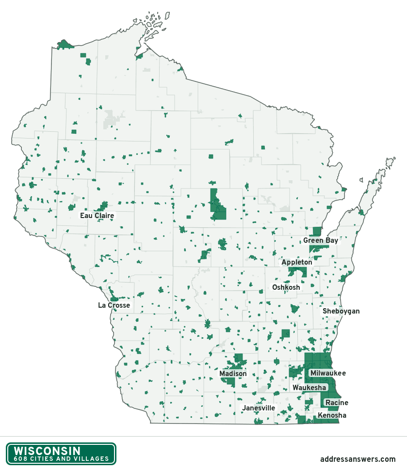
Wisconsin city limits map image
The map above as a picture: every Wisconsin city and town in green, with county lines. Boundaries from the Census Bureau, as of January 1, 2025.
You’re welcome to use it in a document or on your own site, with a link back to this page.
Download the map (PNG, 839 × 972)Questions about Wisconsin city limits
How many cities and villages are in Wisconsin?
Wisconsin has 608 incorporated places: 190 cities and 418 villages, by the Census Bureau’s boundary files for 2025.
What is the largest city in Wisconsin?
By population, Milwaukee, with about 566,973 residents (2020–2024 American Community Survey 5-year estimates). It is also the largest by land area, at 96.2 square miles.
What is the smallest village in Wisconsin?
By the Census Bureau’s estimate, Ingram, with 44 residents. Estimates for places this small have a wide margin of error, so treat it as a rough count.
How much of Wisconsin is unincorporated?
94% of its land and 1.6 million of its residents (27%) are outside every city or village. There, local government is the town and the county. The state also has 200 named unincorporated communities; the largest is Lake Wisconsin.
Is Lake Wisconsin, WI a city?
No. Lake Wisconsin is a census-designated place: a community the Census Bureau maps for statistics, with no city government of its own. About 5,384 people live there, in Columbia County, in a town rather than a city or village. An address there is outside city limits, even if its mailing address says otherwise.
Is Tichigan, WI a city?
No. Tichigan is a census-designated place: a community the Census Bureau maps for statistics, with no city government of its own. About 5,052 people live there, in Racine County, in a town rather than a city or village. An address there is outside city limits, even if its mailing address says otherwise.
Which cities and villages in Wisconsin are in more than one county?
47 of the 608 cross a county line, by at least 1% of their land. The largest: Appleton (Outagamie, Calumet, and Winnebago), Eau Claire (Eau Claire and Chippewa), and Watertown (Jefferson and Dodge). Check an address to see which county it’s in.
Which county in Wisconsin has the most cities and villages?
Waukesha County, with 29 at least partly inside it. Florence County and Menominee County have none.
Bordering states
More answers for a Wisconsin address
Each tool checks the same address and puts its own answer first.
- County Census Your county, plus the township or town where those exist. Find your county
- School district Census The public school district that covers the address. Find your school district
- Flood zone FEMA The FEMA zone in plain English, and whether lenders require flood insurance. Check flood zone
- USDA home loans USDA Whether the property is in an area eligible for a USDA Rural Development loan. Check USDA eligibility
- Voting districts Census Your congressional district and your state senate and state house districts. Included in every check
Places, boundaries, land area and counties: US Census Bureau 2025 cartographic boundary files (boundaries as of January 1, 2025). A place is listed in each county that holds at least 1% of its land. Population: 2020–2024 American Community Survey 5-year estimates. Data updated October 24, 2026; page updated October 25, 2026. Boundaries change through annexation; your city or county has the official map.