Minnesota city limits map
Minnesota has 856 incorporated cities. They cover 5.7% of the state’s land and are home to 83% of its residents. Everyone else lives outside city limits, where local government is the township and the county. Enter an address to see which side of a city line it’s on.
Result for
The map couldn’t load. The answers don’t depend on it.
The boundary couldn’t load. The answer doesn’t depend on it.
Census Geocoder match
More about this address
Sources and limits
- Census
- US Census Bureau Geocoder, current boundaries
- FEMA
- National Flood Hazard Layer, effective flood maps
- USDA
- Rural Development property eligibility
- Map
- Boundaries from Census TIGERweb, flood zones drawn by FEMA, eligible areas from USDA, base map © OpenStreetMap contributors
Census boundaries are updated once a year, so a recent annexation may not show yet. Informational only, not an official determination. Verify with your city or county.
Minnesota at a glance
- Incorporated places
- 856
- 856 cities
- Residents in city limits
- 83%
- 4,784,431 of 5,739,445
- Land in city limits
- 5.7%
- 4,548 of 79,632 sq mi
- Counties
- 87
- Every one has at least one
- Unincorporated communities
- 60
- Largest: Esko (1,813)
- Largest city
- Minneapolis
- 427,246 residents
How local government works in Minnesota
The Census Bureau maps 1,798 townships in Minnesota. Each elects a board of supervisors. Every incorporated place in Minnesota is a city, whatever its size. A township isn’t a city, so an address in one is outside city limits unless it’s also inside a city.
City limits maps for 3 Minnesota cities
Every Minnesota city with 100,000 or more residents has its own page: the boundary in detail, the places around it and its school districts.
All 856 cities in Minnesota
Every incorporated place, largest first, with the counties it’s in and its size. An address inside one of these is inside city limits; anywhere else in the state is unincorporated.
| Name | County | Population | Land (sq mi) |
|---|---|---|---|
| Minneapolis | Hennepin | 427,246 | 54.0 |
| St. Paul | Ramsey | 307,284 | 52.0 |
| Rochester | Olmsted | 122,330 | 56.8 |
| Bloomington | Hennepin | 88,665 | 34.7 |
| Duluth | St. Louis | 87,093 | 71.7 |
| Brooklyn Park | Hennepin | 83,876 | 26.1 |
| Plymouth | Hennepin | 79,220 | 32.7 |
| Woodbury | Washington | 78,305 | 34.9 |
| Lakeville | Dakota | 74,354 | 36.9 |
| Blaine | Anoka | 72,488 | 32.9 |
| Maple Grove | Hennepin | 71,173 | 32.6 |
| St. Cloud | Stearns, Sherburne +1 | 70,629 | 40.2 |
| Eagan | Dakota | 68,000 | 31.2 |
| Burnsville | Dakota | 64,463 | 24.9 |
| Coon Rapids | Anoka | 63,468 | 22.6 |
| Eden Prairie | Hennepin | 63,051 | 32.5 |
| Apple Valley | Dakota | 55,679 | 16.9 |
| Edina | Hennepin | 53,262 | 15.5 |
| Minnetonka | Hennepin | 53,064 | 26.9 |
| St. Louis Park | Hennepin | 49,594 | 10.6 |
| Shakopee | Scott | 46,012 | 29.5 |
| Mankato | Blue Earth, Nicollet | 45,473 | 20.2 |
| Moorhead | Clay | 45,036 | 22.3 |
| Cottage Grove | Washington | 40,992 | 33.6 |
| Maplewood | Ramsey | 40,695 | 17.0 |
| Richfield | Hennepin | 36,642 | 6.78 |
| Inver Grove Heights | Dakota | 35,906 | 27.9 |
| Roseville | Ramsey | 35,802 | 13.0 |
| Andover | Anoka | 33,035 | 33.9 |
| Savage | Scott | 32,889 | 15.6 |
| Brooklyn Center | Hennepin | 32,479 | 8.00 |
| Fridley | Anoka | 30,241 | 10.2 |
| Chaska | Carver | 28,706 | 17.1 |
| Oakdale | Washington | 28,585 | 11.0 |
| Ramsey | Anoka | 28,421 | 28.9 |
| Prior Lake | Scott | 28,016 | 16.3 |
| Rosemount | Dakota | 27,562 | 33.3 |
| Elk River | Sherburne | 26,793 | 42.3 |
| Shoreview | Ramsey | 26,714 | 10.8 |
| Owatonna | Steele | 26,498 | 15.2 |
| Austin | Mower | 26,358 | 13.4 |
| Winona | Winona | 26,009 | 19.0 |
| Chanhassen | Carver | 26,006 | 20.4 |
| Faribault | Rice | 24,631 | 15.7 |
| White Bear Lake | Ramsey, Washington | 23,908 | 8.04 |
| Farmington | Dakota | 23,902 | 15.8 |
| Champlin | Hennepin | 23,294 | 8.15 |
| New Brighton | Ramsey | 22,710 | 6.49 |
| Crystal | Hennepin | 22,476 | 5.79 |
| Otsego | Wright | 22,245 | 29.6 |
| Columbia Heights | Anoka | 22,155 | 3.41 |
| Hastings | Dakota, Washington | 22,117 | 10.4 |
| Lino Lakes | Anoka | 22,113 | 28.2 |
| Golden Valley | Hennepin | 21,725 | 10.2 |
| West St. Paul | Dakota | 21,382 | 4.91 |
| Willmar | Kandiyohi | 21,378 | 14.2 |
| New Hope | Hennepin | 21,181 | 5.06 |
| Northfield | Rice, Dakota | 20,742 | 8.61 |
| Forest Lake | Washington | 20,729 | 30.5 |
| South St. Paul | Dakota | 20,611 | 5.62 |
| St. Michael | Wright | 20,010 | 32.7 |
| Sartell | Stearns, Benton | 19,758 | 10.4 |
| Stillwater | Washington | 19,355 | 8.05 |
| Hopkins | Hennepin | 18,819 | 4.06 |
| Albert Lea | Freeborn | 18,330 | 13.3 |
| Anoka | Anoka | 17,970 | 6.67 |
| Red Wing | Goodhue | 16,758 | 34.8 |
| Ham Lake | Anoka | 16,702 | 34.4 |
| Buffalo | Wright | 16,499 | 7.76 |
| Hugo | Washington | 16,340 | 33.5 |
| Hibbing | St. Louis | 16,057 | 182.0 |
| Bemidji | Beltrami | 15,569 | 17.4 |
| Monticello | Wright | 14,858 | 9.15 |
| Alexandria | Douglas | 14,735 | 17.2 |
| Hutchinson | McLeod | 14,680 | 8.50 |
| Brainerd | Crow Wing | 14,468 | 12.1 |
| Robbinsdale | Hennepin | 14,234 | 2.79 |
| North Mankato | Nicollet | 14,211 | 6.47 |
| Fergus Falls | Otter Tail | 14,181 | 14.4 |
| New Ulm | Brown | 14,056 | 10.2 |
| Marshall | Lyon | 13,896 | 10.3 |
| Sauk Rapids | Benton | 13,852 | 6.29 |
| Worthington | Nobles | 13,780 | 7.90 |
| Rogers | Hennepin | 13,685 | 25.4 |
| Waconia | Carver | 13,434 | 5.61 |
| Lake Elmo | Washington | 13,140 | 22.1 |
| Mounds View | Ramsey | 12,926 | 4.06 |
| Vadnais Heights | Ramsey | 12,838 | 6.97 |
| North St. Paul | Ramsey | 12,570 | 2.86 |
| Cloquet | Carlton | 12,537 | 35.2 |
| Big Lake | Sherburne | 12,367 | 7.23 |
| St. Peter | Nicollet | 12,185 | 6.28 |
| East Bethel | Anoka | 12,115 | 44.6 |
| Mendota Heights | Dakota | 11,612 | 9.07 |
| North Branch | Chisago | 11,565 | 37.3 |
| Victoria | Carver | 11,295 | 12.8 |
| Grand Rapids | Itasca | 11,207 | 22.4 |
| Little Canada | Ramsey | 10,514 | 3.90 |
| Cambridge | Isanti | 10,307 | 7.48 |
| Fairmont | Martin | 10,296 | 15.0 |
| Hermantown | St. Louis | 10,218 | 34.4 |
| Detroit Lakes | Becker | 10,025 | 12.0 |
| St. Anthony | Hennepin, Ramsey | 9,671 | 2.24 |
| Arden Hills | Ramsey | 9,658 | 8.46 |
| Waseca | Waseca | 9,164 | 4.30 |
| Oak Grove | Anoka | 9,130 | 33.9 |
| Little Falls | Morrison | 9,121 | 8.04 |
| Mound | Hennepin | 9,107 | 2.86 |
| Dayton | Hennepin | 9,095 | 23.4 |
| East Grand Forks | Polk | 9,028 | 5.95 |
| Baxter | Crow Wing | 8,966 | 18.9 |
| Thief River Falls | Pennington | 8,823 | 6.00 |
| Minnetrista | Hennepin | 8,708 | 26.1 |
| Waite Park | Stearns | 8,399 | 12.6 |
| St. Francis | Anoka, Isanti | 8,372 | 23.3 |
| Virginia | St. Louis | 8,332 | 18.8 |
| New Prague | Scott, Le Sueur | 8,237 | 3.94 |
| Albertville | Wright | 8,207 | 4.42 |
| Orono | Hennepin | 8,195 | 15.9 |
| Mahtomedi | Washington | 8,133 | 3.47 |
| Wyoming | Chisago | 8,087 | 20.7 |
| Shorewood | Hennepin | 7,647 | 5.31 |
| Belle Plaine | Scott | 7,423 | 5.97 |
| Crookston | Polk | 7,344 | 5.12 |
| Corcoran | Hennepin | 7,302 | 35.8 |
| Isanti | Isanti | 7,210 | 5.09 |
| Kasson | Dodge | 7,050 | 3.50 |
| Spring Lake Park | Anoka, Ramsey | 7,032 | 1.99 |
| St. Joseph | Stearns | 7,021 | 9.29 |
| Medina | Hennepin | 6,968 | 25.6 |
| Delano | Wright | 6,942 | 5.02 |
| Stewartville | Olmsted | 6,807 | 3.36 |
| Jordan | Scott | 6,771 | 3.71 |
| Byron | Olmsted | 6,646 | 3.17 |
| Litchfield | Meeker | 6,576 | 4.51 |
| Zimmerman | Sherburne | 6,546 | 3.77 |
| Carver | Carver | 6,239 | 4.91 |
| Chisago City | Chisago | 5,899 | 17.8 |
| Glencoe | McLeod | 5,695 | 3.17 |
| International Falls | Koochiching | 5,642 | 6.80 |
| Credit River | Scott | 5,551 | 23.4 |
| St. Paul Park | Washington | 5,457 | 3.00 |
| Montevideo | Chippewa | 5,315 | 4.71 |
| Princeton | Mille Lacs, Sherburne | 5,274 | 5.00 |
| La Crescent | Houston, Winona | 5,251 | 3.37 |
| North Oaks | Ramsey | 5,179 | 6.91 |
| Morris | Stevens | 5,128 | 4.70 |
| Falcon Heights | Ramsey | 5,085 | 2.23 |
| Redwood Falls | Redwood | 5,068 | 5.28 |
| Becker | Sherburne, Wright | 5,034 | 11.7 |
| Lake City | Wabasha, Goodhue | 5,034 | 4.49 |
| Elko New Market | Scott | 5,002 | 3.77 |
| Lindstrom | Chisago | 4,978 | 3.82 |
| Circle Pines | Anoka | 4,968 | 1.75 |
| Luverne | Rock | 4,925 | 3.67 |
| Lonsdale | Rice | 4,896 | 2.61 |
| Windom | Cottonwood | 4,799 | 4.15 |
| Watertown | Carver | 4,790 | 2.63 |
| St. James | Watonwan | 4,767 | 2.44 |
| Oak Park Heights | Washington | 4,756 | 2.93 |
| Newport | Washington | 4,754 | 3.62 |
| Dilworth | Clay | 4,713 | 3.46 |
| Chisholm | St. Louis | 4,712 | 4.47 |
| Sauk Centre | Stearns | 4,621 | 4.10 |
| Rockford | Wright, Hennepin | 4,597 | 2.53 |
| Nowthen | Anoka | 4,538 | 33.7 |
| Wadena | Wadena, Otter Tail | 4,419 | 5.53 |
| Stacy | Chisago | 4,384 | 28.5 |
| Wayzata | Hennepin | 4,354 | 3.09 |
| Park Rapids | Hubbard | 4,270 | 7.40 |
| Cold Spring | Stearns | 4,249 | 2.80 |
| Columbus | Anoka | 4,248 | 44.8 |
| Cannon Falls | Goodhue | 4,227 | 4.59 |
| Le Sueur | Le Sueur, Sibley | 4,215 | 5.19 |
| Rice Lake | St. Louis | 4,153 | 32.7 |
| Pipestone | Pipestone | 4,129 | 4.15 |
| Goodview | Winona | 4,103 | 2.20 |
| St. Charles | Winona | 4,037 | 3.75 |
| Grant | Washington | 3,950 | 25.1 |
| Scandia | Washington | 3,950 | 34.9 |
| Centerville | Anoka | 3,935 | 2.13 |
| Zumbrota | Goodhue | 3,914 | 3.03 |
| Bayport | Washington | 3,905 | 1.73 |
| Montrose | Wright | 3,888 | 3.08 |
| Norwood Young America | Carver | 3,849 | 2.46 |
| Deephaven | Hennepin | 3,793 | 2.33 |
| Mora | Kanabec | 3,732 | 5.16 |
| Independence | Hennepin | 3,694 | 32.4 |
| Long Prairie | Todd | 3,693 | 2.75 |
| Melrose | Stearns | 3,671 | 3.17 |
| Perham | Otter Tail | 3,627 | 3.58 |
| Hanover | Wright, Hennepin | 3,626 | 5.49 |
| St. Augusta | Stearns | 3,625 | 29.7 |
| Pine Island | Goodhue, Olmsted | 3,580 | 6.20 |
| Two Harbors | Lake | 3,567 | 3.27 |
| Plainview | Wabasha | 3,500 | 2.14 |
| Pine City | Pine | 3,468 | 4.39 |
| Eveleth | St. Louis | 3,448 | 6.30 |
| Sleepy Eye | Brown | 3,444 | 1.87 |
| Benson | Swift | 3,441 | 3.18 |
| Montgomery | Le Sueur | 3,434 | 2.51 |
| Annandale | Wright | 3,399 | 3.20 |
| Breckenridge | Wilkin | 3,349 | 2.60 |
| Rush City | Chisago | 3,295 | 4.25 |
| Jackson | Jackson | 3,287 | 5.19 |
| Eagle Lake | Blue Earth | 3,281 | 1.93 |
| Ely | St. Louis | 3,240 | 2.93 |
| Blue Earth | Faribault | 3,165 | 3.32 |
| Proctor | St. Louis | 3,100 | 3.36 |
| Empire | Dakota | 3,092 | 30.5 |
| Milaca | Mille Lacs | 3,044 | 3.41 |
| Afton | Washington | 2,957 | 25.1 |
| Greenfield | Hennepin | 2,894 | 20.4 |
| Dodge Center | Dodge | 2,880 | 2.41 |
| Moose Lake | Carlton | 2,863 | 3.28 |
| Mountain Iron | St. Louis | 2,860 | 68.1 |
| Albany | Stearns | 2,821 | 2.18 |
| Caledonia | Houston | 2,820 | 2.82 |
| Cokato | Wright | 2,782 | 1.55 |
| Lexington | Anoka | 2,770 | 0.69 |
| Barnesville | Clay | 2,762 | 2.00 |
| Roseau | Roseau | 2,736 | 2.69 |
| Cohasset | Itasca | 2,703 | 27.7 |
| Breezy Point | Crow Wing | 2,687 | 11.7 |
| Granite Falls | Chippewa, Yellow Medicine | 2,685 | 3.55 |
| Foley | Benton | 2,675 | 2.61 |
| Glenwood | Pope | 2,633 | 5.72 |
| Lake Crystal | Blue Earth | 2,606 | 1.71 |
| Wabasha | Wabasha | 2,587 | 8.19 |
| Pelican Rapids | Otter Tail | 2,586 | 2.58 |
| Osseo | Hennepin | 2,584 | 0.74 |
| Excelsior | Hennepin | 2,570 | 0.63 |
| Chatfield | Fillmore, Olmsted | 2,559 | 2.59 |
| Crosslake | Crow Wing | 2,521 | 25.8 |
| Paynesville | Stearns | 2,519 | 2.29 |
| Mayer | Carver | 2,518 | 1.37 |
| Le Center | Le Sueur | 2,513 | 1.68 |
| Sandstone | Pine | 2,482 | 5.26 |
| Rockville | Stearns | 2,452 | 28.7 |
| Lauderdale | Ramsey | 2,388 | 0.42 |
| Janesville | Waseca | 2,378 | 1.54 |
| Madelia | Watonwan | 2,327 | 1.51 |
| Aitkin | Aitkin | 2,323 | 2.96 |
| Spring Valley | Fillmore | 2,307 | 2.96 |
| Wells | Faribault | 2,296 | 2.09 |
| Waverly | Wright | 2,285 | 1.66 |
| Cologne | Carver | 2,282 | 1.79 |
| Staples | Wadena, Todd | 2,269 | 4.76 |
| Crosby | Crow Wing | 2,218 | 2.96 |
| Olivia | Renville | 2,205 | 2.42 |
| Winsted | McLeod | 2,181 | 1.90 |
| Hawley | Clay | 2,178 | 2.62 |
| Coleraine | Itasca | 2,150 | 15.4 |
| Slayton | Murray | 2,141 | 2.06 |
| Springfield | Brown | 2,125 | 1.88 |
| Rice | Benton | 2,085 | 5.70 |
| Pequot Lakes | Crow Wing | 2,079 | 16.4 |
| Gaylord | Sibley | 2,073 | 1.89 |
| Mountain Lake | Cottonwood | 2,070 | 1.72 |
| Arlington | Sibley | 2,065 | 1.61 |
| Hoyt Lakes | St. Louis | 2,064 | 55.9 |
| Tracy | Lyon | 2,057 | 2.40 |
| Maple Lake | Wright | 2,042 | 2.21 |
| Ortonville | Big Stone | 2,028 | 4.19 |
| St. Bonifacius | Hennepin | 1,997 | 1.04 |
| Clearwater | Wright, Stearns | 1,970 | 1.79 |
| Warroad | Roseau | 1,959 | 3.27 |
| Nisswa | Crow Wing | 1,954 | 10.8 |
| Waterville | Le Sueur | 1,947 | 1.69 |
| Eyota | Olmsted | 1,944 | 1.69 |
| Dundas | Rice | 1,916 | 1.85 |
| Lester Prairie | McLeod | 1,898 | 1.00 |
| Spring Park | Hennepin | 1,896 | 0.35 |
| Blooming Prairie | Steele | 1,843 | 1.36 |
| Ada | Norman | 1,833 | 1.34 |
| Howard Lake | Wright | 1,832 | 1.85 |
| Rushford | Fillmore | 1,826 | 1.65 |
| Kenyon | Goodhue | 1,824 | 2.31 |
| Grand Marais | Cook | 1,796 | 2.91 |
| Aurora | St. Louis | 1,792 | 3.70 |
| Silver Bay | Lake | 1,769 | 7.63 |
| Rock Creek | Pine | 1,748 | 43.0 |
| Braham | Isanti, Kanabec | 1,732 | 1.62 |
| Long Lake | Hennepin | 1,728 | 0.86 |
| Mapleton | Blue Earth | 1,728 | 1.37 |
| Maple Plain | Hennepin | 1,701 | 1.06 |
| Gilbert | St. Louis | 1,697 | 11.7 |
| Warren | Marshall | 1,680 | 1.46 |
| Oronoco | Olmsted | 1,679 | 2.93 |
| Frazee | Becker | 1,647 | 1.07 |
| Osakis | Douglas, Todd | 1,623 | 1.92 |
| Lewiston | Winona | 1,613 | 1.27 |
| Hinckley | Pine | 1,596 | 3.79 |
| Minneota | Lyon | 1,594 | 1.45 |
| Canby | Yellow Medicine | 1,556 | 2.24 |
| Avon | Stearns | 1,552 | 1.70 |
| Madison | Lac qui Parle | 1,550 | 1.15 |
| Dawson | Lac qui Parle | 1,513 | 1.44 |
| Lakefield | Jackson | 1,507 | 1.34 |
| Renville | Renville | 1,503 | 1.32 |
| Lakeland | Washington | 1,492 | 2.07 |
| Clara City | Chippewa | 1,466 | 1.88 |
| Richmond | Stearns | 1,431 | 1.19 |
| Pierz | Morrison | 1,424 | 1.38 |
| Hayfield | Dodge | 1,395 | 1.25 |
| Appleton | Swift | 1,393 | 1.89 |
| Babbitt | St. Louis | 1,393 | 106.0 |
| Fulda | Murray | 1,393 | 1.01 |
| Wanamingo | Goodhue | 1,389 | 1.42 |
| Wheaton | Traverse | 1,389 | 1.74 |
| Winthrop | Sibley | 1,381 | 1.28 |
| Fosston | Polk | 1,374 | 2.01 |
| New York Mills | Otter Tail | 1,371 | 1.51 |
| Preston | Fillmore | 1,362 | 2.46 |
| Dassel | Meeker | 1,358 | 1.68 |
| Red Lake Falls | Red Lake | 1,348 | 2.10 |
| Menahga | Wadena | 1,343 | 3.71 |
| Madison Lake | Blue Earth | 1,322 | 1.37 |
| Elbow Lake | Grant | 1,301 | 1.38 |
| Winnebago | Faribault | 1,280 | 2.34 |
| Tonka Bay | Hennepin | 1,270 | 0.94 |
| Morristown | Rice | 1,265 | 1.12 |
| Medford | Steele | 1,257 | 1.19 |
| Bagley | Clearwater | 1,248 | 2.15 |
| Adrian | Nobles | 1,236 | 1.17 |
| Starbuck | Pope | 1,235 | 1.48 |
| Spicer | Kandiyohi | 1,222 | 1.22 |
| Keewatin | Itasca | 1,215 | 2.62 |
| Truman | Martin | 1,212 | 1.10 |
| Royalton | Morrison, Benton | 1,211 | 2.01 |
| Atwater | Kandiyohi | 1,203 | 1.03 |
| New London | Kandiyohi | 1,187 | 1.29 |
| Shafer | Chisago | 1,186 | 1.27 |
| New Richland | Waseca | 1,184 | 0.59 |
| Dellwood | Washington | 1,181 | 2.66 |
| Spring Grove | Houston | 1,177 | 0.99 |
| Taylors Falls | Chisago | 1,167 | 3.98 |
| Scanlon | Carlton | 1,146 | 0.86 |
| Baudette | Lake of the Woods | 1,139 | 4.23 |
| Hector | Renville | 1,130 | 1.81 |
| Elgin | Wabasha | 1,116 | 0.93 |
| Lake St. Croix Beach | Washington | 1,105 | 0.56 |
| Edgerton | Pipestone | 1,104 | 1.18 |
| Glyndon | Clay | 1,098 | 1.58 |
| Tyler | Lincoln | 1,090 | 2.10 |
| Fairfax | Renville | 1,088 | 1.31 |
| East Gull Lake | Cass | 1,076 | 7.88 |
| Goodhue | Goodhue | 1,074 | 1.10 |
| Lake Shore | Cass | 1,073 | 12.7 |
| Cottonwood | Lyon | 1,061 | 1.00 |
| Hilltop | Anoka | 1,053 | 0.12 |
| Mahnomen | Mahnomen | 1,049 | 1.06 |
| Mantorville | Dodge | 1,047 | 1.56 |
| Harmony | Fillmore | 1,024 | 1.11 |
| Buhl | St. Louis | 1,022 | 3.31 |
| Sherburn | Martin | 1,015 | 0.92 |
| Grand Meadow | Mower | 1,011 | 0.69 |
| Mazeppa | Wabasha | 1,004 | 1.09 |
| Eden Valley | Meeker, Stearns | 1,002 | 1.34 |
| Houston | Houston | 982 | 1.23 |
| Parkers Prairie | Otter Tail | 980 | 1.25 |
| Welcome | Martin | 978 | 1.46 |
| Biwabik | St. Louis | 966 | 8.76 |
| Nicollet | Nicollet | 957 | 0.91 |
| Bird Island | Renville | 930 | 1.46 |
| Nashwauk | Itasca | 926 | 15.2 |
| Morgan | Redwood | 925 | 0.55 |
| Gibbon | Sibley | 918 | 0.66 |
| Lamberton | Redwood | 917 | 0.76 |
| Clarkfield | Yellow Medicine | 913 | 1.13 |
| Pine River | Cass | 906 | 1.20 |
| Browerville | Todd | 902 | 1.09 |
| Dover | Olmsted | 895 | 1.00 |
| Deer River | Itasca | 889 | 1.52 |
| Carlton | Carlton | 875 | 3.81 |
| Henderson | Sibley | 875 | 1.07 |
| Birchwood Village | Washington | 866 | 0.33 |
| Henning | Otter Tail | 860 | 3.30 |
| Hancock | Stevens | 859 | 0.90 |
| Brownsdale | Mower | 850 | 0.41 |
| Walker | Cass | 848 | 2.81 |
| McIntosh | Polk | 847 | 1.00 |
| West Concord | Dodge | 843 | 1.07 |
| Hallock | Kittson | 829 | 2.13 |
| Jasper | Rock, Pipestone | 818 | 1.02 |
| Silver Lake | McLeod | 815 | 0.41 |
| Grove City | Meeker | 814 | 0.61 |
| Stockton | Winona | 811 | 1.70 |
| Rushford Village | Fillmore | 809 | 33.5 |
| Walnut Grove | Redwood | 808 | 1.09 |
| Fertile | Polk | 803 | 2.08 |
| Le Roy | Mower | 803 | 0.71 |
| Kerkhoven | Swift | 802 | 0.84 |
| Lake Benton | Lincoln | 794 | 3.21 |
| Westbrook | Cottonwood | 792 | 0.62 |
| Freeport | Stearns | 787 | 1.19 |
| Battle Lake | Otter Tail | 786 | 1.44 |
| Loretto | Hennepin | 784 | 0.26 |
| Harris | Chisago | 776 | 20.0 |
| Landfall | Washington | 776 | 0.07 |
| Lilydale | Dakota | 772 | 0.55 |
| Courtland | Nicollet | 770 | 2.61 |
| Watkins | Meeker | 765 | 0.69 |
| Belgrade | Stearns | 758 | 1.20 |
| Foreston | Mille Lacs | 757 | 1.44 |
| Ellendale | Steele | 754 | 0.83 |
| Hills | Rock | 748 | 0.63 |
| Adams | Mower | 745 | 1.00 |
| Lanesboro | Fillmore | 744 | 1.52 |
| Marine on St. Croix | Washington | 740 | 3.91 |
| Hoffman | Grant | 730 | 2.10 |
| Mabel | Fillmore | 730 | 0.48 |
| Sebeka | Wadena | 725 | 2.47 |
| Onamia | Mille Lacs | 719 | 0.96 |
| Twin Valley | Norman | 719 | 0.85 |
| Holdingford | Stearns | 718 | 0.90 |
| Sabin | Clay | 718 | 0.45 |
| Deerwood | Crow Wing | 710 | 1.49 |
| St. Clair | Blue Earth | 710 | 0.65 |
| Kimball | Stearns | 709 | 1.51 |
| Blackduck | Beltrami | 699 | 2.33 |
| Greenwood | Hennepin | 699 | 0.36 |
| Isle | Mille Lacs | 695 | 2.71 |
| Randall | Morrison | 695 | 2.00 |
| St. Stephen | Stearns | 694 | 3.72 |
| Emily | Crow Wing | 693 | 30.0 |
| Raymond | Kandiyohi, Chippewa | 692 | 0.89 |
| Brewster | Nobles | 687 | 1.38 |
| Minnesota Lake | Faribault, Blue Earth | 687 | 1.62 |
| Greenbush | Roseau | 678 | 1.54 |
| Elysian | Le Sueur, Waseca | 676 | 1.18 |
| Marble | Itasca | 669 | 4.37 |
| Hokah | Houston | 668 | 0.70 |
| Center City | Chisago | 651 | 0.59 |
| Prinsburg | Kandiyohi | 651 | 1.01 |
| Bovey | Itasca | 646 | 2.30 |
| Stewart | McLeod | 644 | 0.81 |
| Clarks Grove | Freeborn | 636 | 0.60 |
| Littlefork | Koochiching | 636 | 1.19 |
| Buffalo Lake | Renville | 635 | 0.68 |
| Cass Lake | Cass | 635 | 1.09 |
| Alden | Freeborn | 629 | 0.96 |
| Clarissa | Todd | 622 | 1.01 |
| Karlstad | Kittson | 622 | 1.50 |
| Ironton | Crow Wing | 621 | 1.45 |
| Rollingstone | Winona | 620 | 0.44 |
| Brownsville | Houston | 609 | 1.85 |
| Ivanhoe | Lincoln | 609 | 0.65 |
| Motley | Morrison, Cass | 608 | 1.39 |
| Wabasso | Redwood | 603 | 0.85 |
| Amboy | Blue Earth | 602 | 0.32 |
| Brooten | Stearns | 602 | 1.59 |
| Lake Park | Becker | 600 | 0.97 |
| Eagle Bend | Todd | 597 | 1.35 |
| Medicine Lake | Hennepin | 596 | 0.17 |
| New Germany | Carver | 595 | 1.00 |
| Heron Lake | Jackson | 593 | 1.24 |
| La Prairie | Itasca | 592 | 1.65 |
| Hampton | Dakota | 590 | 1.23 |
| Clearbrook | Clearwater | 584 | 0.49 |
| Clear Lake | Sherburne | 579 | 1.04 |
| Glenville | Freeborn | 572 | 1.05 |
| Sturgeon Lake | Pine | 568 | 3.77 |
| Graceville | Big Stone | 564 | 0.58 |
| Milan | Chippewa | 564 | 0.68 |
| Cleveland | Le Sueur | 563 | 0.55 |
| Kasota | Le Sueur | 554 | 1.24 |
| Balaton | Lyon | 551 | 1.45 |
| Evansville | Douglas | 550 | 0.78 |
| Pennock | Kandiyohi | 549 | 1.02 |
| Hamburg | Carver | 547 | 0.21 |
| Pillager | Cass | 547 | 0.85 |
| Brownton | McLeod | 546 | 0.40 |
| Trimont | Martin | 546 | 0.79 |
| Cosmos | Meeker | 536 | 0.98 |
| Butterfield | Watonwan | 535 | 0.41 |
| Sunfish Lake | Dakota | 533 | 1.50 |
| Franklin | Renville | 526 | 1.01 |
| Stephen | Marshall | 526 | 0.79 |
| Hendricks | Lincoln | 517 | 0.97 |
| Kellogg | Wabasha | 513 | 0.31 |
| Carlos | Douglas | 512 | 0.45 |
| Halstad | Norman | 509 | 0.36 |
| Ranier | Koochiching | 509 | 1.07 |
| Jenkins | Crow Wing | 508 | 4.47 |
| Lyle | Mower | 504 | 0.76 |
| Barnum | Carlton | 503 | 1.01 |
| Hill City | Aitkin | 503 | 1.11 |
| Claremont | Dodge | 502 | 1.08 |
| Floodwood | St. Louis | 497 | 1.92 |
| Nevis | Hubbard | 496 | 0.93 |
| Willernie | Washington | 495 | 0.13 |
| Kiester | Faribault | 494 | 0.43 |
| Fountain | Fillmore | 493 | 0.99 |
| Kandiyohi | Kandiyohi | 493 | 0.39 |
| Ottertail | Otter Tail | 490 | 4.28 |
| Argyle | Marshall | 486 | 1.51 |
| Lafayette | Nicollet | 484 | 1.26 |
| Gem Lake | Ramsey | 483 | 1.04 |
| St. Marys Point | Washington | 483 | 0.39 |
| Sacred Heart | Renville | 481 | 0.99 |
| Fifty Lakes | Crow Wing | 478 | 29.3 |
| Woodland | Hennepin | 477 | 0.57 |
| Bertha | Todd | 474 | 1.08 |
| Bethel | Anoka | 474 | 0.98 |
| Danube | Renville | 472 | 0.49 |
| Village of Minnetonka Beach | Hennepin | 469 | 0.47 |
| Taconite | Itasca | 468 | 28.0 |
| Green Isle | Sibley | 466 | 1.02 |
| Randolph | Dakota | 461 | 0.95 |
| Underwood | Otter Tail | 461 | 0.59 |
| Good Thunder | Blue Earth | 456 | 0.63 |
| Rothsay | Wilkin, Otter Tail | 454 | 0.86 |
| Verndale | Wadena | 452 | 1.03 |
| Brandon | Douglas | 451 | 0.48 |
| Elmore | Faribault | 451 | 0.85 |
| Herman | Grant | 441 | 1.11 |
| Ghent | Lyon | 439 | 0.31 |
| New Auburn | Sibley | 436 | 0.68 |
| Rose Creek | Mower | 429 | 0.49 |
| Ellsworth | Nobles | 428 | 0.66 |
| Lynd | Lyon | 428 | 1.14 |
| Erskine | Polk | 427 | 0.65 |
| Cook | St. Louis | 423 | 2.60 |
| Cromwell | Carlton | 423 | 1.84 |
| Hartland | Freeborn | 422 | 0.27 |
| Waubun | Mahnomen | 419 | 0.51 |
| Miltona | Douglas | 418 | 0.67 |
| Upsala | Morrison | 417 | 3.24 |
| Racine | Mower | 416 | 0.67 |
| Ulen | Clay | 413 | 1.07 |
| Wrenshall | Carlton | 404 | 1.49 |
| Vermillion | Dakota | 399 | 0.99 |
| Canton | Fillmore | 398 | 1.03 |
| Fisher | Polk | 396 | 0.43 |
| Pine Springs | Washington | 395 | 0.77 |
| Ashby | Grant | 394 | 0.55 |
| Bricelyn | Faribault | 392 | 0.29 |
| Chokio | Stevens | 392 | 0.44 |
| Badger | Roseau | 391 | 1.34 |
| Altura | Winona | 388 | 2.98 |
| Audubon | Becker | 388 | 0.72 |
| Geneva | Freeborn | 387 | 0.47 |
| Morton | Renville | 384 | 1.21 |
| Oklee | Red Lake | 383 | 0.75 |
| Browns Valley | Traverse | 382 | 0.79 |
| Hanska | Brown | 380 | 0.25 |
| Wykoff | Fillmore | 377 | 0.93 |
| Bigfork | Itasca | 375 | 1.86 |
| Remer | Cass | 371 | 1.33 |
| Plummer | Red Lake | 369 | 2.67 |
| Jeffers | Cottonwood | 368 | 0.39 |
| Orr | St. Louis | 368 | 1.40 |
| Wood Lake | Yellow Medicine | 368 | 0.75 |
| McGregor | Aitkin | 367 | 2.14 |
| Tower | St. Louis | 367 | 2.92 |
| Emmons | Freeborn | 363 | 0.85 |
| Belview | Redwood | 362 | 0.92 |
| Rushmore | Nobles | 362 | 0.25 |
| Darwin | Meeker | 358 | 1.99 |
| Cyrus | Pope | 355 | 0.27 |
| Dexter | Mower | 350 | 1.41 |
| Barrett | Grant | 349 | 2.09 |
| Freeborn | Freeborn | 348 | 0.18 |
| Lowry | Pope | 348 | 0.45 |
| Russell | Lyon | 346 | 0.92 |
| Lakeland Shores | Washington | 344 | 0.32 |
| Willow River | Pine | 342 | 1.78 |
| Kelliher | Beltrami | 341 | 2.20 |
| Hollandale | Freeborn | 340 | 0.44 |
| Buckman | Morrison | 339 | 1.01 |
| Comfrey | Brown, Cottonwood | 338 | 0.43 |
| Round Lake | Nobles | 333 | 0.73 |
| Newfolden | Marshall | 332 | 1.02 |
| Chandler | Murray | 331 | 0.79 |
| Murdock | Swift | 331 | 0.62 |
| Deer Creek | Otter Tail | 330 | 4.01 |
| Vernon Center | Blue Earth | 329 | 0.49 |
| Wilton | Beltrami | 327 | 2.95 |
| Ogilvie | Kanabec | 322 | 0.89 |
| Middle River | Marshall | 319 | 0.50 |
| Long Beach | Pope | 318 | 1.43 |
| Alvarado | Marshall | 317 | 0.21 |
| Lancaster | Kittson | 315 | 2.33 |
| Hitterdal | Clay | 314 | 0.86 |
| Ostrander | Fillmore | 313 | 0.47 |
| St. Martin | Stearns | 313 | 0.87 |
| Vesta | Redwood | 311 | 0.40 |
| Skyline | Blue Earth | 307 | 0.20 |
| Askov | Pine | 304 | 1.26 |
| Dakota | Winona | 304 | 0.55 |
| New Munich | Stearns | 299 | 0.53 |
| Sanborn | Redwood | 299 | 2.07 |
| Bigelow | Nobles | 297 | 0.39 |
| Grey Eagle | Todd | 295 | 0.36 |
| Beaver Creek | Rock | 293 | 0.53 |
| Holland | Pipestone | 292 | 0.91 |
| Backus | Cass | 291 | 0.62 |
| Akeley | Hubbard | 289 | 1.47 |
| Hewitt | Todd | 283 | 2.06 |
| Garfield | Douglas | 282 | 0.81 |
| Clinton | Big Stone | 281 | 0.96 |
| Eitzen | Houston | 281 | 0.61 |
| Wilmont | Nobles | 280 | 0.58 |
| Calumet | Itasca | 279 | 1.80 |
| Bowlus | Morrison | 278 | 1.28 |
| Donnelly | Stevens | 277 | 2.78 |
| Frost | Faribault | 275 | 0.44 |
| Rutledge | Pine | 275 | 2.95 |
| Swanville | Morrison, Todd | 274 | 0.53 |
| Greenwald | Stearns | 270 | 0.71 |
| Gary | Norman | 268 | 0.58 |
| Finlayson | Pine | 267 | 2.41 |
| Grygla | Marshall | 266 | 0.58 |
| Bluffton | Otter Tail | 263 | 2.73 |
| Oslo | Marshall | 260 | 0.37 |
| Ceylon | Martin | 259 | 0.52 |
| St. Hilaire | Pennington | 259 | 0.78 |
| Vergas | Otter Tail | 258 | 1.57 |
| Wahkon | Mille Lacs | 258 | 0.99 |
| Ogema | Becker | 257 | 1.16 |
| Lewisville | Watonwan | 255 | 0.25 |
| Cuyuna | Crow Wing | 250 | 3.23 |
| Chickamaw Beach | Cass | 248 | 2.25 |
| Hackensack | Cass | 248 | 1.02 |
| Hanley Falls | Yellow Medicine | 248 | 0.25 |
| Millville | Wabasha | 247 | 0.15 |
| Campbell | Wilkin | 245 | 0.24 |
| Peterson | Fillmore | 244 | 0.48 |
| Storden | Cottonwood | 244 | 0.22 |
| Granada | Martin | 243 | 0.57 |
| Plato | McLeod | 242 | 0.32 |
| Hendrum | Norman | 240 | 0.25 |
| Kensington | Douglas | 240 | 0.36 |
| Northrop | Martin | 240 | 0.13 |
| Lake Wilson | Murray | 237 | 0.41 |
| Williams | Lake of the Woods | 237 | 0.98 |
| Villard | Pope | 236 | 0.85 |
| Hardwick | Rock | 235 | 1.76 |
| Heidelberg | Le Sueur | 235 | 0.52 |
| Maynard | Chippewa | 234 | 0.60 |
| Gilman | Benton | 233 | 0.71 |
| Lismore | Nobles | 233 | 0.35 |
| Hayward | Freeborn | 231 | 0.61 |
| Dent | Otter Tail | 230 | 0.36 |
| Beardsley | Big Stone | 229 | 0.47 |
| Shelly | Norman | 229 | 0.21 |
| Bellechester | Goodhue, Wabasha | 227 | 0.32 |
| Callaway | Becker | 224 | 0.63 |
| Dalton | Otter Tail | 223 | 0.24 |
| Dennison | Goodhue, Rice | 223 | 1.26 |
| Pemberton | Blue Earth | 223 | 0.19 |
| Ruthton | Pipestone | 222 | 0.58 |
| Gonvick | Clearwater | 221 | 1.31 |
| Currie | Murray | 220 | 0.55 |
| Lucan | Redwood | 220 | 0.40 |
| Elrosa | Stearns | 217 | 0.16 |
| Pease | Mille Lacs | 217 | 0.53 |
| Utica | Winona | 216 | 0.99 |
| Magnolia | Rock | 215 | 0.80 |
| Nerstrand | Rice | 215 | 1.41 |
| Iona | Murray | 214 | 0.55 |
| South Haven | Wright | 214 | 0.64 |
| Okabena | Jackson | 210 | 0.34 |
| Climax | Polk | 209 | 0.94 |
| Mendota | Dakota | 207 | 0.26 |
| Tenstrike | Beltrami | 207 | 3.31 |
| Kingston | Meeker | 206 | 0.55 |
| Milroy | Redwood | 203 | 0.26 |
| Watson | Chippewa | 200 | 0.18 |
| Woodstock | Pipestone | 200 | 0.54 |
| Flensburg | Morrison | 199 | 6.98 |
| Echo | Yellow Medicine | 197 | 0.37 |
| Sobieski | Morrison | 192 | 4.00 |
| Porter | Yellow Medicine | 191 | 2.00 |
| Lake Bronson | Kittson | 190 | 0.53 |
| Felton | Clay | 186 | 1.01 |
| Wendell | Grant | 186 | 0.99 |
| Waltham | Mower | 182 | 0.48 |
| Easton | Faribault | 178 | 0.95 |
| Dunnell | Martin | 177 | 0.15 |
| Meadowlands | St. Louis | 174 | 0.39 |
| Boyd | Lac qui Parle | 172 | 0.51 |
| Elmdale | Morrison | 172 | 3.44 |
| Waldorf | Waseca | 171 | 0.38 |
| Kennedy | Kittson | 170 | 0.45 |
| Harding | Morrison | 169 | 3.10 |
| Meire Grove | Stearns | 167 | 0.39 |
| Marietta | Lac qui Parle | 166 | 0.37 |
| Forada | Douglas | 161 | 0.54 |
| Delavan | Faribault | 160 | 1.01 |
| Northome | Koochiching | 159 | 1.46 |
| Twin Lakes | Freeborn | 158 | 0.49 |
| Lake Lillian | Kandiyohi | 157 | 0.45 |
| Winger | Polk | 157 | 0.32 |
| Zumbro Falls | Wabasha | 157 | 0.58 |
| Garrison | Crow Wing | 156 | 1.05 |
| Nelson | Douglas | 155 | 0.66 |
| Erhard | Otter Tail | 154 | 0.55 |
| St. Leo | Yellow Medicine | 153 | 0.25 |
| Roosevelt | Roseau, Lake of the Woods | 150 | 1.03 |
| Palisade | Aitkin | 148 | 0.68 |
| Shevlin | Clearwater | 148 | 0.80 |
| Bellingham | Lac qui Parle | 146 | 0.39 |
| Warba | Itasca | 146 | 3.23 |
| Riverton | Crow Wing | 145 | 0.81 |
| Wolverton | Wilkin | 145 | 0.35 |
| Brook Park | Pine | 143 | 0.99 |
| Federal Dam | Cass | 142 | 2.21 |
| Dumont | Traverse | 140 | 0.43 |
| Kettle River | Carlton | 140 | 0.39 |
| Biscay | McLeod | 138 | 0.08 |
| Longville | Cass | 138 | 0.85 |
| Big Falls | Koochiching | 136 | 6.04 |
| Ormsby | Watonwan, Martin | 136 | 0.35 |
| Minnesota City | Winona | 135 | 0.26 |
| Hammond | Wabasha | 134 | 0.16 |
| Brooks | Red Lake | 133 | 1.15 |
| Borup | Norman | 132 | 0.25 |
| Coates | Dakota | 131 | 1.50 |
| Mentor | Polk | 131 | 1.90 |
| Blomkest | Kandiyohi | 129 | 1.02 |
| Taunton | Lyon | 128 | 1.01 |
| Danvers | Swift | 126 | 0.69 |
| Odin | Watonwan | 126 | 0.37 |
| Perley | Norman | 126 | 0.25 |
| Kilkenny | Le Sueur | 125 | 0.14 |
| Miesville | Dakota | 125 | 1.75 |
| Steen | Rock | 125 | 0.44 |
| Viking | Marshall | 125 | 0.52 |
| Winton | St. Louis | 124 | 0.12 |
| Trommald | Crow Wing | 123 | 3.69 |
| Elizabeth | Otter Tail | 122 | 0.37 |
| Nimrod | Wadena | 118 | 0.95 |
| Solway | Beltrami | 117 | 1.03 |
| Millerville | Douglas | 116 | 0.86 |
| Kinney | St. Louis | 115 | 3.91 |
| Alpha | Jackson | 114 | 0.21 |
| Garvin | Lyon | 114 | 0.28 |
| Grasston | Kanabec | 112 | 0.93 |
| Clitherall | Otter Tail | 111 | 0.19 |
| Minneiska | Wabasha, Winona | 111 | 0.52 |
| Foxhome | Wilkin | 110 | 0.37 |
| Mapleview | Mower | 110 | 0.19 |
| Bejou | Mahnomen | 109 | 0.29 |
| Clements | Redwood | 109 | 0.38 |
| Norcross | Grant | 106 | 1.56 |
| Sunburg | Kandiyohi | 106 | 0.47 |
| Squaw Lake | Itasca | 104 | 0.81 |
| Wanda | Redwood | 104 | 0.26 |
| Brookston | St. Louis | 103 | 0.55 |
| Elba | Winona | 102 | 1.94 |
| Nielsville | Polk | 102 | 0.21 |
| Avoca | Murray | 100 | 0.96 |
| Comstock | Clay | 100 | 0.23 |
| Seaforth | Redwood | 100 | 1.02 |
| Conger | Freeborn | 99 | 0.13 |
| Spring Hill | Stearns | 97 | 0.73 |
| Roscoe | Stearns | 96 | 0.62 |
| Wright | Carlton | 96 | 1.46 |
| Bingham Lake | Cottonwood | 95 | 0.80 |
| Holt | Marshall | 95 | 1.00 |
| Burtrum | Todd | 94 | 0.57 |
| Elkton | Mower | 94 | 1.28 |
| Alberta | Stevens | 93 | 0.26 |
| McKinley | St. Louis | 92 | 1.43 |
| Ihlen | Pipestone | 91 | 0.37 |
| Strandquist | Marshall | 91 | 0.26 |
| Evan | Brown | 89 | 1.03 |
| Lastrup | Morrison | 88 | 0.37 |
| Odessa | Big Stone | 87 | 0.96 |
| Iron Junction | St. Louis | 86 | 0.81 |
| Vining | Otter Tail | 86 | 1.15 |
| Beaver Bay | Lake | 82 | 0.80 |
| Quamba | Kanabec | 82 | 0.70 |
| Genola | Morrison | 81 | 0.31 |
| Bena | Cass | 79 | 0.50 |
| Dundee | Nobles | 79 | 0.31 |
| New Trier | Dakota | 78 | 0.19 |
| Effie | Itasca | 77 | 3.73 |
| Lake Henry | Stearns | 77 | 0.20 |
| Darfur | Watonwan | 74 | 0.23 |
| Holloway | Swift | 74 | 1.40 |
| Wolf Lake | Becker | 73 | 0.32 |
| Beltrami | Polk | 72 | 2.00 |
| Georgetown | Clay | 72 | 1.02 |
| Kenneth | Rock | 72 | 1.06 |
| Laporte | Hubbard | 71 | 0.70 |
| Kent | Wilkin | 70 | 0.24 |
| West Union | Todd | 69 | 0.44 |
| Fort Ripley | Crow Wing | 68 | 1.29 |
| Arco | Lincoln | 66 | 0.29 |
| Kerrick | Pine | 64 | 1.00 |
| Revere | Redwood | 64 | 0.57 |
| St. Rosa | Stearns | 62 | 0.37 |
| De Graff | Swift | 58 | 0.83 |
| Hazel Run | Yellow Medicine | 58 | 0.76 |
| Mizpah | Koochiching | 58 | 3.02 |
| Turtle River | Beltrami | 58 | 1.07 |
| St. Anthony | Stearns | 57 | 0.49 |
| Walters | Faribault | 57 | 0.20 |
| Funkley | Beltrami | 55 | 0.76 |
| Gully | Polk | 53 | 0.25 |
| Taopi | Mower | 51 | 0.39 |
| Trosky | Pipestone | 51 | 1.41 |
| Bock | Mille Lacs | 49 | 0.17 |
| Goodridge | Pennington | 49 | 0.19 |
| Nassau | Lac qui Parle | 49 | 0.16 |
| Zemple | Itasca | 49 | 0.65 |
| Hatfield | Pipestone | 46 | 2.79 |
| Clontarf | Swift | 45 | 2.08 |
| St. Vincent | Kittson | 45 | 1.03 |
| Whalan | Fillmore | 45 | 0.43 |
| Humboldt | Kittson | 44 | 0.11 |
| Richville | Otter Tail | 44 | 0.99 |
| Farwell | Pope | 43 | 0.25 |
| Lengby | Polk | 43 | 0.25 |
| Tamarack | Aitkin | 43 | 3.50 |
| Tintah | Traverse | 43 | 0.75 |
| Bruno | Pine | 42 | 1.00 |
| Dovray | Murray | 41 | 0.25 |
| Cedar Mills | Meeker | 40 | 0.32 |
| Sedan | Pope | 40 | 0.51 |
| Urbank | Otter Tail | 40 | 0.66 |
| Aldrich | Wadena | 37 | 0.49 |
| Henriette | Pine | 37 | 0.28 |
| Leonidas | St. Louis | 37 | 1.33 |
| Westport | Pope | 37 | 0.26 |
| Halma | Kittson | 36 | 0.94 |
| Strathcona | Roseau | 34 | 0.50 |
| Delhi | Redwood | 33 | 0.76 |
| Denham | Pine | 33 | 1.33 |
| Regal | Kandiyohi | 33 | 0.51 |
| Manchester | Freeborn | 32 | 0.07 |
| Wilder | Jackson | 32 | 0.79 |
| Myrtle | Freeborn | 31 | 0.10 |
| Sargeant | Mower | 30 | 0.80 |
| Hadley | Murray | 29 | 0.29 |
| La Salle | Watonwan | 28 | 0.09 |
| McGrath | Aitkin | 28 | 0.37 |
| Hillman | Morrison | 27 | 0.62 |
| Florence | Lyon | 25 | 0.11 |
| Manhattan Beach | Crow Wing | 25 | 1.53 |
| Nashua | Wilkin | 21 | 3.51 |
| Johnson | Big Stone | 20 | 0.31 |
| Louisburg | Lac qui Parle | 20 | 0.25 |
| Correll | Big Stone | 18 | 0.38 |
| Barry | Big Stone | 16 | 0.25 |
| Trail | Polk | 16 | 1.00 |
| Cobden | Brown | 12 | 0.99 |
| Doran | Wilkin | 12 | 0.20 |
| Leonard | Clearwater | 12 | 0.46 |
| Boy River | Cass | 6 | 0.37 |
| Donaldson | Kittson | 5 | 0.23 |
| Kinbrae | Nobles | 2 | 0.87 |
| Baldwin | Sherburne | – | 32.9 |
Showing 1–50 of 856
Unincorporated communities in Minnesota
Census-designated places: named communities the Census Bureau maps for statistics, with no city government of their own. An address in one is outside city limits, even when its mailing address names a city. Minnesota has 60.
| Community | County | Population | Land (sq mi) |
|---|---|---|---|
| Esko | Carlton | 1,813 | 4.86 |
| St. John's University | Stearns | 1,580 | 0.65 |
| Redby | Beltrami | 1,495 | 7.29 |
| Red Lake | Beltrami | 1,481 | 5.08 |
| Martin Lake | Anoka | 1,068 | 1.38 |
| Little Rock | Beltrami | 944 | 7.21 |
| Vineland | Mille Lacs | 674 | 9.32 |
| The Lakes | Murray | 594 | 33.7 |
| Warsaw | Rice | 560 | 0.86 |
| White Earth | Becker | 506 | 3.41 |
| Naytahwaush | Mahnomen | 478 | 2.90 |
| Mahtowa | Carlton | 428 | 10.6 |
| Crown College | Carver | 422 | 0.31 |
| Soudan | St. Louis | 415 | 0.68 |
| Ponemah | Beltrami | 391 | 11.0 |
| Big Lake | Carlton | 378 | 2.12 |
| Marion | Olmsted | 314 | 1.86 |
| Osage | Becker | 290 | 2.73 |
| Dresbach | Winona | 286 | 0.95 |
| Finland | Lake | 257 | 6.72 |
| Fairhaven | Stearns | 255 | 1.91 |
| Rice Lake | Clearwater | 244 | 10.4 |
| Pine Point | Becker | 241 | 3.60 |
| Riverland | Mahnomen | 239 | 0.22 |
| Lutsen | Cook | 222 | 10.6 |
| Lake George | Hubbard | 204 | 5.07 |
| Searles | Brown | 201 | 0.44 |
| Twin Lakes | Mahnomen | 197 | 2.67 |
| Mahnomen | St. Louis | 195 | 1.27 |
| Garden City | Blue Earth | 194 | 1.79 |
| Frontenac | Goodhue | 188 | 1.84 |
| Homer | Winona | 179 | 1.19 |
| Nett Lake | St. Louis | 171 | 1.72 |
| Pickwick | Winona | 171 | 0.64 |
| Leota | Nobles | 169 | 1.52 |
| Silver Creek | Wright | 167 | 1.49 |
| Lansing | Mower | 152 | 0.79 |
| Knife River | Lake | 131 | 0.67 |
| Ball Club | Itasca | 127 | 2.76 |
| High Forest | Olmsted | 124 | 0.33 |
| Merrifield | Crow Wing | 121 | 0.54 |
| Stanchfield | Isanti | 100 | 0.74 |
| Fish Lake | Jackson | 93 | 0.91 |
| Inger | Itasca | 88 | 1.88 |
| Elbow Lake | Becker | 76 | 1.34 |
| Essig | Brown | 76 | 0.65 |
| Whipholt | Cass | 76 | 3.25 |
| Ebro | Clearwater | 75 | 0.87 |
| Ronneby | Benton | 67 | 0.96 |
| Beaulieu | Mahnomen | 63 | 3.87 |
| Roy Lake | Clearwater | 61 | 0.45 |
| Hubbard | Hubbard | 53 | 0.10 |
| Baker | Clay | 52 | 1.01 |
| South End | Clearwater | 38 | 1.77 |
| Midway | Mahnomen | 35 | 1.85 |
| West Roy Lake | Mahnomen | 30 | 1.61 |
| Goodland | Itasca | 24 | 0.12 |
| Pine Bend | Mahnomen | 11 | 1.26 |
| The Ranch | Mahnomen | 3 | 0.31 |
| Angle Inlet | Lake of the Woods | 0 | 1.74 |
Showing 1–50 of 60
Counties in Minnesota
87 counties, with how many cities have land in each and the largest whose main county it is.
| County | Cities | Largest | Population | Land (sq mi) |
|---|---|---|---|---|
| Hennepin County | 44 | Minneapolis | 1,269,496 | 554.0 |
| Ramsey County | 17 | St. Paul | 542,945 | 152.3 |
| Dakota County | 22 | Lakeville | 445,771 | 562.6 |
| Anoka County | 20 | Blaine | 370,349 | 422.0 |
| Washington County | 27 | Woodbury | 276,238 | 384.8 |
| St. Louis County | 27 | Duluth | 200,123 | 6,248 |
| Olmsted County | 8 | Rochester | 164,498 | 653.5 |
| Stearns County | 31 | St. Cloud | 160,865 | 1,343 |
| Scott County | 8 | Shakopee | 154,557 | 356.1 |
| Wright County | 17 | Otsego | 148,269 | 661.2 |
| Carver County | 11 | Chaska | 110,041 | 353.9 |
| Sherburne County | 8 | Elk River | 100,560 | 432.9 |
| Blue Earth County | 12 | Mankato | 69,871 | 747.8 |
| Rice County | 7 | Faribault | 67,917 | 495.8 |
| Crow Wing County | 18 | Brainerd | 67,686 | 998.5 |
| Clay County | 11 | Moorhead | 66,059 | 1,045 |
| Otter Tail County | 22 | Fergus Falls | 60,475 | 1,972 |
| Chisago County | 10 | North Branch | 57,991 | 414.9 |
| Winona County | 13 | Winona | 49,779 | 626.2 |
| Goodhue County | 10 | Red Wing | 47,943 | 756.7 |
| Beltrami County | 8 | Bemidji | 46,512 | 2,505 |
| Itasca County | 16 | Grand Rapids | 45,275 | 2,668 |
| Kandiyohi County | 12 | Willmar | 44,079 | 797.4 |
| Isanti County | 4 | Cambridge | 42,596 | 435.8 |
| Benton County | 7 | Sauk Rapids | 41,593 | 408.3 |
| Mower County | 14 | Austin | 40,343 | 711.3 |
| Douglas County | 11 | Alexandria | 39,575 | 636.9 |
| Steele County | 4 | Owatonna | 37,439 | 429.6 |
| McLeod County | 9 | Hutchinson | 36,798 | 491.5 |
| Carlton County | 9 | Cloquet | 36,518 | 861.2 |
| Becker County | 7 | Detroit Lakes | 35,343 | 1,315 |
| Nicollet County | 6 | North Mankato | 34,411 | 448.5 |
| Morrison County | 16 | Little Falls | 34,249 | 1,125 |
| Cass County | 15 | East Gull Lake | 30,992 | 2,022 |
| Polk County | 15 | East Grand Forks | 30,705 | 1,971 |
| Freeborn County | 14 | Albert Lea | 30,623 | 707.2 |
| Pine County | 14 | Pine City | 29,640 | 1,411 |
| Le Sueur County | 10 | Le Sueur | 29,113 | 448.8 |
| Mille Lacs County | 8 | Princeton | 27,125 | 572.3 |
| Brown County | 7 | New Ulm | 25,800 | 611.1 |
| Todd County | 12 | Long Prairie | 25,575 | 945.1 |
| Lyon County | 11 | Marshall | 25,503 | 714.4 |
| Meeker County | 9 | Litchfield | 23,468 | 608.0 |
| Nobles County | 11 | Worthington | 22,041 | 715.1 |
| Hubbard County | 4 | Park Rapids | 21,831 | 926.0 |
| Wabasha County | 11 | Lake City | 21,565 | 523.0 |
| Fillmore County | 14 | Chatfield | 21,414 | 861.3 |
| Dodge County | 6 | Kasson | 21,045 | 439.4 |
| Martin County | 10 | Fairmont | 19,780 | 712.3 |
| Waseca County | 5 | Waseca | 18,885 | 423.4 |
| Houston County | 7 | La Crescent | 18,653 | 552.1 |
| Kanabec County | 5 | Mora | 16,390 | 521.6 |
| Aitkin County | 6 | Aitkin | 16,056 | 1,821 |
| Redwood County | 15 | Redwood Falls | 15,350 | 878.6 |
| Roseau County | 6 | Roseau | 15,302 | 1,672 |
| Sibley County | 8 | Gaylord | 15,005 | 589.0 |
| Renville County | 10 | Olivia | 14,558 | 982.9 |
| Wadena County | 7 | Wadena | 14,256 | 536.3 |
| Faribault County | 11 | Blue Earth | 13,914 | 712.5 |
| Pennington County | 3 | Thief River Falls | 13,791 | 616.5 |
| Chippewa County | 7 | Montevideo | 12,377 | 581.2 |
| Koochiching County | 6 | International Falls | 11,833 | 3,105 |
| Cottonwood County | 7 | Windom | 11,458 | 640.0 |
| Pope County | 9 | Glenwood | 11,418 | 674.6 |
| Watonwan County | 8 | St. James | 11,205 | 434.9 |
| Lake County | 3 | Two Harbors | 10,879 | 2,109 |
| Jackson County | 6 | Jackson | 9,933 | 703.0 |
| Swift County | 8 | Benson | 9,748 | 742.0 |
| Stevens County | 5 | Morris | 9,739 | 563.7 |
| Rock County | 8 | Luverne | 9,621 | 482.5 |
| Yellow Medicine County | 9 | Canby | 9,451 | 759.1 |
| Pipestone County | 9 | Pipestone | 9,284 | 465.1 |
| Marshall County | 11 | Warren | 8,909 | 1,775 |
| Clearwater County | 5 | Bagley | 8,616 | 999.0 |
| Murray County | 9 | Slayton | 8,097 | 704.7 |
| Lac qui Parle County | 7 | Madison | 6,682 | 765.0 |
| Wilkin County | 8 | Breckenridge | 6,371 | 751.0 |
| Norman County | 8 | Ada | 6,367 | 872.8 |
| Grant County | 7 | Elbow Lake | 6,127 | 547.8 |
| Cook County | 1 | Grand Marais | 5,635 | 1,453 |
| Lincoln County | 5 | Tyler | 5,603 | 536.8 |
| Mahnomen County | 3 | Mahnomen | 5,358 | 557.9 |
| Big Stone County | 8 | Ortonville | 5,127 | 499.1 |
| Kittson County | 9 | Hallock | 4,084 | 1,099 |
| Red Lake County | 4 | Red Lake Falls | 3,915 | 432.4 |
| Lake of the Woods County | 3 | Baudette | 3,821 | 1,298 |
| Traverse County | 4 | Wheaton | 3,243 | 573.9 |
Showing 1–50 of 87
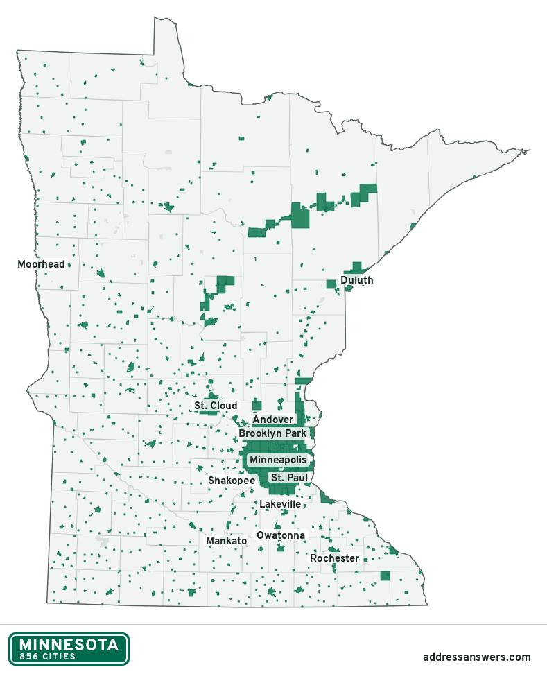
Minnesota city limits map image
The map above as a picture: every Minnesota city and town in green, with county lines. Boundaries from the Census Bureau, as of January 1, 2025.
You’re welcome to use it in a document or on your own site, with a link back to this page.
Download the map (PNG, 789 × 972)Questions about Minnesota city limits
How many cities are in Minnesota?
Minnesota has 856 incorporated places: 856 cities, by the Census Bureau’s boundary files for 2025.
What is the largest city in Minnesota?
By population, Minneapolis, with about 427,246 residents (2020–2024 American Community Survey 5-year estimates). By land area the largest is Hibbing, at 182.0 square miles (Minneapolis: 54.0).
What is the smallest city in Minnesota?
By the Census Bureau’s estimate, Kinbrae, with 2 residents. Estimates for places this small have a wide margin of error, so treat it as a rough count.
How much of Minnesota is unincorporated?
94% of its land and 955,014 of its residents (17%) are outside every city. There, local government is the township and the county. The state also has 60 named unincorporated communities; the largest is Esko.
Is Esko, MN a city?
No. Esko is a census-designated place: a community the Census Bureau maps for statistics, with no city government of its own. About 1,813 people live there, in Carlton County, in a township rather than a city. An address there is outside city limits, even if its mailing address says otherwise.
Is St. John's University, MN a city?
No. St. John's University is a census-designated place: a community the Census Bureau maps for statistics, with no city government of its own. About 1,580 people live there, in Stearns County, in a township rather than a city. An address there is outside city limits, even if its mailing address says otherwise.
Which cities in Minnesota are in more than one county?
40 of the 856 cross a county line, by at least 1% of their land. The largest: St. Cloud (Stearns, Sherburne, and Benton), Mankato (Blue Earth and Nicollet), and White Bear Lake (Ramsey and Washington). Check an address to see which county it’s in.
Which county in Minnesota has the most cities?
Hennepin County, with 44 at least partly inside it. Every county in Minnesota has at least one.
Bordering states
More answers for a Minnesota address
Each tool checks the same address and puts its own answer first.
- County Census Your county, plus the township or town where those exist. Find your county
- School district Census The public school district that covers the address. Find your school district
- Flood zone FEMA The FEMA zone in plain English, and whether lenders require flood insurance. Check flood zone
- USDA home loans USDA Whether the property is in an area eligible for a USDA Rural Development loan. Check USDA eligibility
- Voting districts Census Your congressional district and your state senate and state house districts. Included in every check
Places, boundaries, land area and counties: US Census Bureau 2025 cartographic boundary files (boundaries as of January 1, 2025). A place is listed in each county that holds at least 1% of its land. Population: 2020–2024 American Community Survey 5-year estimates. Data updated October 24, 2026; page updated October 25, 2026. Boundaries change through annexation; your city or county has the official map.