South Dakota city limits map
South Dakota has 310 incorporated places: 157 cities, 152 towns, and 1 village. They cover 0.7% of the state’s land and are home to 73% of its residents. Everyone else lives outside city limits, where local government is the county. Enter an address to see which side of a city line it’s on.
Result for
The map couldn’t load. The answers don’t depend on it.
The boundary couldn’t load. The answer doesn’t depend on it.
Census Geocoder match
More about this address
Sources and limits
- Census
- US Census Bureau Geocoder, current boundaries
- FEMA
- National Flood Hazard Layer, effective flood maps
- USDA
- Rural Development property eligibility
- Map
- Boundaries from Census TIGERweb, flood zones drawn by FEMA, eligible areas from USDA, base map © OpenStreetMap contributors
Census boundaries are updated once a year, so a recent annexation may not show yet. Informational only, not an official determination. Verify with your city or county.
South Dakota at a glance
- Incorporated places
- 310
- 157 cities, 152 towns, and 1 village
- Residents in city limits
- 73%
- 664,036 of 907,428
- Land in city limits
- 0.7%
- 552.7 of 75,808 sq mi
- Counties
- 66
- 1 with no city or town
- Unincorporated communities
- 175
- Largest: Rapid Valley (6,975)
- Largest city
- Sioux Falls
- 201,469 residents
How local government works in South Dakota
The Census Bureau maps 900 townships in South Dakota. Many have elected officers who look after rural roads; others exist only on maps. A township isn’t a city, so an address in one is outside city limits unless it’s also inside a city.
City limits map for Sioux Falls
Its own page has the boundary in detail, the communities around it and its school districts.
All 310 cities and towns in South Dakota
Every incorporated place, largest first, with the counties it’s in and its size. An address inside one of these is inside city limits; anywhere else in the state is unincorporated.
| Name | Type | County | Population | Land (sq mi) |
|---|---|---|---|---|
| Sioux Falls | City | Minnehaha, Lincoln | 201,469 | 84.5 |
| Rapid City | City | Pennington | 77,946 | 56.0 |
| Aberdeen | City | Brown | 28,189 | 16.6 |
| Brookings | City | Brookings | 23,948 | 14.0 |
| Watertown | City | Codington | 23,044 | 18.4 |
| Mitchell | City | Davison | 15,649 | 11.5 |
| Yankton | City | Yankton | 15,540 | 8.74 |
| Huron | City | Beadle | 14,385 | 9.85 |
| Pierre | City | Hughes | 13,948 | 13.0 |
| Spearfish | City | Lawrence | 12,930 | 17.3 |
| Box Elder | City | Pennington, Meade | 12,902 | 14.9 |
| Vermillion | City | Clay | 11,878 | 4.79 |
| Brandon | City | Minnehaha | 10,996 | 6.10 |
| Harrisburg | City | Lincoln | 8,519 | 4.77 |
| Sturgis | City | Meade | 7,086 | 6.56 |
| Tea | City | Lincoln | 6,786 | 3.86 |
| Madison | City | Lake | 6,094 | 4.62 |
| Belle Fourche | City | Butte | 5,804 | 9.08 |
| Dell Rapids | City | Minnehaha | 3,905 | 2.25 |
| Hot Springs | City | Fall River | 3,548 | 4.36 |
| Milbank | City | Grant | 3,525 | 2.77 |
| Hartford | City | Minnehaha | 3,478 | 3.74 |
| North Sioux City | City | Union | 3,045 | 3.34 |
| Canton | City | Lincoln | 3,033 | 3.27 |
| Summerset | City | Meade | 3,022 | 3.00 |
| Lead | City | Lawrence | 3,006 | 2.06 |
| Mobridge | City | Walworth | 2,932 | 1.96 |
| Winner | City | Tripp | 2,905 | 2.29 |
| Sisseton | City | Roberts | 2,670 | 1.59 |
| Chamberlain | City | Brule | 2,588 | 4.48 |
| Elk Point | City | Union | 2,537 | 1.55 |
| Lennox | City | Lincoln | 2,468 | 1.82 |
| Fort Pierre | City | Stanley | 2,410 | 3.12 |
| Volga | City | Brookings | 2,408 | 1.14 |
| Flandreau | City | Moody | 2,392 | 1.86 |
| Beresford | City | Union, Lincoln | 2,360 | 1.78 |
| Custer | City | Custer | 2,341 | 2.58 |
| Springfield | City | Bon Homme | 2,038 | 1.03 |
| Redfield | City | Spink | 1,989 | 1.93 |
| Webster | City | Day | 1,896 | 1.62 |
| Parkston | City | Hutchinson | 1,874 | 1.31 |
| Groton | City | Brown | 1,691 | 1.75 |
| Freeman | City | Hutchinson | 1,565 | 1.49 |
| Mission | City | Todd | 1,539 | 0.59 |
| Wagner | City | Charles Mix | 1,529 | 1.86 |
| Baltic | City | Minnehaha | 1,502 | 0.74 |
| Eagle Butte | City | Ziebach, Dewey | 1,458 | 1.36 |
| Aurora | Town | Brookings | 1,444 | 0.84 |
| Gregory | City | Gregory | 1,379 | 1.72 |
| Miller | City | Hand | 1,363 | 0.99 |
| Clark | City | Clark | 1,359 | 1.35 |
| Clear Lake | City | Deuel | 1,327 | 3.44 |
| Parker | City | Turner | 1,280 | 1.18 |
| Crooks | City | Minnehaha | 1,268 | 1.29 |
| Gettysburg | City | Potter | 1,260 | 1.92 |
| Salem | City | McCook | 1,216 | 1.25 |
| Deadwood | City | Lawrence | 1,209 | 4.93 |
| Lemmon | City | Perkins | 1,208 | 1.10 |
| Tyndall | City | Bon Homme | 1,183 | 1.58 |
| Garretson | City | Minnehaha | 1,176 | 1.46 |
| Platte | City | Charles Mix | 1,161 | 1.05 |
| Ipswich | City | Edmunds | 1,048 | 1.34 |
| Worthing | City | Lincoln | 1,036 | 0.56 |
| Valley Springs | City | Minnehaha | 996 | 0.98 |
| Alcester | City | Union | 989 | 1.03 |
| Britton | City | Marshall | 988 | 0.73 |
| Marion | City | Turner | 981 | 0.87 |
| Piedmont | City | Meade | 981 | 1.82 |
| Elkton | City | Brookings | 977 | 1.49 |
| Viborg | City | Turner | 958 | 0.52 |
| Colman | City | Moody | 948 | 1.88 |
| Martin | City | Bennett | 947 | 0.56 |
| De Smet | City | Kingsbury | 943 | 1.16 |
| Howard | City | Miner | 943 | 0.96 |
| Arlington | City | Kingsbury, Brookings | 920 | 1.72 |
| Whitewood | City | Lawrence | 912 | 0.67 |
| Centerville | City | Turner | 903 | 0.72 |
| Lake Andes | City | Charles Mix | 901 | 0.75 |
| Lake Norden | City | Hamlin | 889 | 0.87 |
| Edgemont | City | Fall River | 860 | 1.38 |
| Scotland | City | Bon Homme | 851 | 0.90 |
| Hill City | City | Pennington | 834 | 1.31 |
| Estelline | City | Hamlin | 831 | 0.95 |
| Castlewood | City | Hamlin | 804 | 1.15 |
| Timber Lake | City | Dewey | 779 | 0.61 |
| Eureka | City | McPherson | 778 | 0.93 |
| Woonsocket | City | Sanborn | 759 | 0.78 |
| Colton | City | Minnehaha | 736 | 0.70 |
| Humboldt | Town | Minnehaha | 732 | 0.62 |
| Bryant | City | Hamlin | 727 | 0.52 |
| Wessington Springs | City | Jerauld | 727 | 1.80 |
| Canistota | City | McCook | 711 | 0.56 |
| Burke | City | Gregory | 708 | 0.56 |
| Big Stone City | City | Grant | 706 | 1.20 |
| Avon | City | Bon Homme | 704 | 0.65 |
| Selby | City | Walworth | 702 | 0.71 |
| Corsica | City | Douglas | 699 | 0.84 |
| Alexandria | City | Hanson | 692 | 0.62 |
| Wolsey | Town | Beadle | 692 | 2.26 |
| McLaughlin | City | Corson | 683 | 0.40 |
| Armour | City | Douglas | 675 | 0.94 |
| Faulkton | City | Faulk | 670 | 1.01 |
| Menno | City | Hutchinson | 653 | 0.52 |
| Onida | City | Sully | 644 | 0.67 |
| Wall | Town | Pennington | 622 | 2.63 |
| White River | City | Mellette | 606 | 0.52 |
| Plankinton | City | Aurora | 603 | 0.76 |
| Murdo | City | Jones | 599 | 0.63 |
| Highmore | City | Hyde | 596 | 1.88 |
| Lake Preston | City | Kingsbury | 596 | 0.76 |
| St. Francis | Town | Todd | 593 | 0.36 |
| Tripp | City | Hutchinson | 574 | 0.59 |
| Philip | City | Haakon | 571 | 0.62 |
| Herreid | City | Campbell | 560 | 1.43 |
| Dupree | City | Ziebach | 557 | 0.39 |
| Jefferson | City | Union | 554 | 0.51 |
| Oacoma | Town | Lyman | 548 | 2.63 |
| Emery | City | Hanson | 539 | 0.46 |
| Ramona | Town | Lake | 538 | 0.27 |
| Gayville | Town | Yankton | 519 | 0.24 |
| Warner | Town | Brown | 512 | 0.28 |
| New Underwood | City | Pennington | 509 | 1.66 |
| White | City | Brookings | 484 | 0.87 |
| Montrose | City | McCook | 483 | 0.42 |
| Langford | Town | Marshall | 481 | 0.32 |
| Bowdle | City | Edmunds | 475 | 0.64 |
| White Lake | City | Aurora | 469 | 0.40 |
| Kimball | City | Brule | 457 | 3.44 |
| Irene | City | Turner, Clay +1 | 456 | 0.26 |
| Veblen | City | Marshall | 455 | 0.31 |
| Bridgewater | City | McCook | 451 | 1.13 |
| Hayti | Town | Hamlin | 444 | 0.46 |
| Mount Vernon | City | Davison | 442 | 0.34 |
| Willow Lake | City | Clark | 433 | 0.37 |
| Rosholt | Town | Roberts | 428 | 0.30 |
| Chancellor | Town | Turner | 421 | 0.22 |
| Bison | Town | Perkins | 406 | 0.99 |
| Wakonda | Town | Clay | 399 | 0.39 |
| Hurley | City | Turner | 394 | 0.62 |
| Iroquois | City | Kingsbury, Beadle | 389 | 0.62 |
| Hudson | Town | Lincoln | 382 | 0.28 |
| Leola | City | McPherson | 381 | 0.74 |
| Wilmot | City | Roberts | 381 | 0.53 |
| Newell | City | Butte | 378 | 1.01 |
| Kadoka | City | Jackson | 372 | 2.29 |
| Tabor | Town | Bon Homme | 369 | 0.38 |
| Summit | Town | Roberts | 359 | 0.55 |
| Hermosa | Town | Custer, Pennington | 353 | 0.86 |
| Ethan | Town | Davison | 346 | 0.26 |
| Trent | Town | Moody | 341 | 1.04 |
| Colome | City | Tripp | 338 | 0.28 |
| Waubay | City | Day | 337 | 1.46 |
| Keystone | Town | Pennington | 336 | 3.00 |
| Hoven | Town | Potter | 329 | 0.31 |
| Alpena | Town | Jerauld | 317 | 1.63 |
| Florence | Town | Codington | 317 | 0.69 |
| Roscoe | City | Edmunds | 316 | 0.38 |
| Presho | City | Lyman | 313 | 0.67 |
| Pukwana | Town | Brule | 300 | 0.77 |
| Faith | City | Meade | 297 | 1.28 |
| Kennebec | Town | Lyman | 296 | 0.85 |
| Bruce | City | Brookings | 290 | 0.37 |
| Hosmer | City | Edmunds | 289 | 0.99 |
| Bonesteel | City | Gregory | 286 | 0.35 |
| Stickney | Town | Aurora | 284 | 0.27 |
| Buffalo | Town | Harding | 278 | 0.55 |
| Bristol | City | Day | 275 | 0.52 |
| Pickstown | Town | Charles Mix | 275 | 0.61 |
| Pollock | Town | Campbell | 270 | 0.32 |
| New Effington | Town | Roberts | 269 | 0.26 |
| Gary | City | Deuel | 246 | 0.67 |
| Toronto | Town | Deuel | 238 | 0.31 |
| Henry | Town | Codington | 237 | 1.45 |
| Monroe | Town | Turner | 233 | 0.38 |
| Eden | Town | Marshall | 221 | 0.15 |
| Blunt | City | Hughes | 216 | 0.49 |
| Sinai | Town | Brookings | 215 | 0.37 |
| Isabel | Town | Dewey | 214 | 0.84 |
| Reliance | Town | Lyman | 211 | 1.09 |
| Doland | City | Spink | 209 | 0.61 |
| Pringle | Town | Custer | 206 | 0.24 |
| Ashton | City | Spink | 204 | 0.44 |
| Mission Hill | Town | Yankton | 200 | 0.33 |
| Hazel | Town | Hamlin | 199 | 0.24 |
| Mellette | City | Spink | 199 | 0.26 |
| Oelrichs | Town | Fall River | 198 | 0.37 |
| Egan | City | Moody | 194 | 1.07 |
| Wessington | City | Beadle, Hand | 192 | 0.38 |
| Cavour | Town | Beadle | 186 | 0.41 |
| Delmont | City | Douglas | 183 | 0.76 |
| South Shore | Town | Codington | 183 | 1.40 |
| Hecla | City | Brown | 182 | 0.34 |
| Kranzburg | Town | Codington | 175 | 0.76 |
| Tulare | Town | Spink | 175 | 0.26 |
| St. Lawrence | Town | Hand | 172 | 0.34 |
| Letcher | Town | Sanborn | 171 | 0.62 |
| Badger | Town | Kingsbury | 162 | 1.06 |
| Columbia | City | Brown | 161 | 1.52 |
| Pierpont | Town | Day | 161 | 0.15 |
| Frederick | Town | Brown | 160 | 1.35 |
| Canova | Town | Miner | 159 | 0.31 |
| Geddes | City | Charles Mix | 158 | 0.73 |
| Northville | Town | Spink | 153 | 0.38 |
| Artesian | Town | Sanborn | 148 | 0.55 |
| Roslyn | Town | Day | 147 | 0.22 |
| Peever | Town | Roberts | 145 | 0.12 |
| Astoria | Town | Deuel | 142 | 0.16 |
| Central City | City | Lawrence | 140 | 0.16 |
| Volin | Town | Yankton | 139 | 0.20 |
| Wentworth | Village | Lake | 138 | 0.25 |
| Midland | Town | Haakon | 135 | 0.34 |
| Fruitdale | Town | Butte | 134 | 0.27 |
| Buffalo Gap | Town | Custer | 131 | 0.31 |
| Conde | City | Spink | 128 | 0.56 |
| Frankfort | City | Spink | 128 | 0.79 |
| Cresbard | Town | Faulk | 122 | 0.41 |
| Yale | Town | Beadle | 122 | 0.15 |
| Dante | Town | Charles Mix | 120 | 0.50 |
| Fairfax | Town | Gregory | 119 | 0.30 |
| Belvidere | Town | Jackson | 114 | 0.76 |
| Nisland | Town | Butte | 109 | 0.27 |
| Claire City | Town | Roberts | 107 | 0.18 |
| Claremont | Town | Brown | 106 | 0.25 |
| Erwin | Town | Kingsbury | 105 | 0.48 |
| Akaska | Town | Walworth | 104 | 0.61 |
| Dimock | Town | Hutchinson | 104 | 0.17 |
| Spencer | City | McCook | 103 | 0.27 |
| Dallas | Town | Gregory | 102 | 0.51 |
| Fairview | Town | Lincoln | 102 | 0.09 |
| Goodwin | Town | Deuel | 101 | 0.47 |
| Naples | Town | Clark | 96 | 0.14 |
| Glenham | Town | Walworth | 95 | 0.33 |
| Westport | Town | Brown | 93 | 0.23 |
| Hitchcock | Town | Beadle | 91 | 0.27 |
| Lesterville | Town | Yankton | 91 | 0.20 |
| Orient | Town | Faulk | 91 | 0.29 |
| Mound City | Town | Campbell | 90 | 0.13 |
| Batesland | Town | Oglala Lakota | 89 | 0.09 |
| Revillo | Town | Grant | 88 | 0.17 |
| Corona | Town | Roberts | 87 | 0.25 |
| Fulton | Town | Hanson | 84 | 0.85 |
| Brentford | Town | Spink | 83 | 0.16 |
| Brandt | Town | Deuel | 82 | 1.26 |
| Raymond | Town | Clark | 82 | 0.26 |
| Agar | Town | Sully | 81 | 0.21 |
| La Bolt | Town | Grant | 80 | 0.24 |
| McIntosh | City | Corson | 80 | 0.73 |
| Bradley | Town | Clark | 78 | 0.25 |
| Carthage | City | Miner | 78 | 1.46 |
| Garden City | Town | Clark | 78 | 0.39 |
| Java | Town | Walworth | 78 | 0.49 |
| Interior | Town | Jackson | 77 | 1.34 |
| Davis | Town | Turner | 76 | 0.43 |
| Lebanon | Town | Potter | 76 | 0.53 |
| Morristown | Town | Corson | 76 | 0.35 |
| New Witten | Town | Tripp | 76 | 0.28 |
| Oldham | City | Kingsbury | 75 | 0.25 |
| Stockholm | Town | Grant | 74 | 0.43 |
| Herrick | Town | Gregory | 73 | 0.52 |
| Ortley | Town | Roberts | 73 | 2.24 |
| Harrold | Town | Hughes | 72 | 0.41 |
| Wasta | Town | Pennington | 70 | 0.19 |
| Utica | Town | Yankton | 68 | 0.26 |
| Bushnell | Town | Brookings | 66 | 0.71 |
| Cottonwood | Town | Jackson | 66 | 0.92 |
| Wallace | Town | Codington | 66 | 0.13 |
| Sherman | Town | Minnehaha | 65 | 0.26 |
| Brant Lake | City | Lake | 63 | 0.15 |
| Olivet | Town | Hutchinson | 63 | 0.14 |
| Stratford | Town | Brown | 62 | 0.25 |
| Chelsea | Town | Faulk | 61 | 0.32 |
| Fairburn | Town | Custer | 61 | 0.33 |
| Turton | Town | Spink | 61 | 0.37 |
| Strandburg | Town | Grant | 58 | 0.07 |
| Tolstoy | Town | Potter | 57 | 0.18 |
| Grenville | Town | Day | 53 | 0.24 |
| Ward | Town | Moody | 52 | 0.29 |
| Vienna | Town | Clark | 49 | 0.84 |
| Quinn | Town | Pennington | 48 | 1.20 |
| Altamont | Town | Deuel | 46 | 1.25 |
| Ravinia | Town | Charles Mix | 45 | 0.25 |
| Camp Crook | Town | Harding | 41 | 0.14 |
| Lake City | Town | Marshall | 40 | 0.22 |
| Nunda | Town | Lake | 40 | 1.01 |
| Wood | Town | Mellette | 40 | 0.25 |
| Ree Heights | Town | Hand | 38 | 0.30 |
| Rockham | Town | Faulk | 37 | 0.50 |
| Andover | Town | Day | 31 | 0.27 |
| Farmer | Town | Hanson | 31 | 0.08 |
| Twin Brooks | Town | Grant | 29 | 0.41 |
| Lane | Town | Jerauld | 28 | 0.46 |
| Onaka | Town | Faulk | 25 | 0.26 |
| Seneca | Town | Faulk | 22 | 0.42 |
| Dolton | Town | Turner | 21 | 0.26 |
| Vilas | Town | Miner | 21 | 2.98 |
| Draper | Town | Jones | 20 | 0.65 |
| Virgil | Town | Beadle | 20 | 1.00 |
| Marvin | Town | Grant | 19 | 0.55 |
| Bancroft | Town | Kingsbury | 16 | 0.23 |
| Broadland | Town | Beadle | 15 | 1.01 |
| Long Lake | Town | McPherson | 14 | 0.28 |
| White Rock | Town | Roberts | 12 | 1.57 |
| Hetland | Town | Kingsbury | 10 | 0.11 |
| Wetonka | Town | McPherson | 7 | 0.25 |
| Albee | Town | Grant | 4 | 0.13 |
| Verdon | Town | Brown | 4 | 0.25 |
| Artas | Town | Campbell | 3 | 0.10 |
| Butler | Town | Day | 2 | 0.29 |
| Lowry | Town | Walworth | 1 | 0.25 |
| Hillsview | Town | McPherson | 0 | 0.64 |
Showing 1–50 of 310
Unincorporated communities in South Dakota
Census-designated places: named communities the Census Bureau maps for statistics, with no city government of their own. An address in one is outside city limits, even when its mailing address names a city. South Dakota has 175.
| Community | County | Population | Land (sq mi) |
|---|---|---|---|
| Rapid Valley | Pennington | 6,975 | 6.41 |
| Dakota Dunes | Union | 3,936 | 2.47 |
| Blackhawk | Meade | 2,934 | 4.74 |
| Colonial Pine Hills | Pennington | 2,609 | 15.3 |
| Pine Ridge | Oglala Lakota | 2,246 | 2.83 |
| North Spearfish | Lawrence | 1,858 | 4.27 |
| Rosebud | Todd | 1,659 | 13.0 |
| Green Valley | Pennington | 1,642 | 3.84 |
| North Eagle Butte | Dewey | 1,481 | 8.82 |
| Fort Thompson | Buffalo | 1,147 | 10.4 |
| Ashland Heights | Pennington | 1,105 | 2.91 |
| Oglala | Oglala Lakota | 1,071 | 12.5 |
| Agency Village | Roberts | 980 | 7.15 |
| Lake Madison | Lake | 936 | 4.71 |
| Meadow View Addition | Minnehaha | 879 | 1.08 |
| Boulder Canyon | Lawrence | 841 | 3.06 |
| Manderson-White Horse Creek | Oglala Lakota | 833 | 5.73 |
| Allen | Bennett | 783 | 3.24 |
| Mina | Edmunds | 767 | 3.78 |
| Wonderland Homes | Meade | 745 | 0.24 |
| Lower Brule | Lyman | 743 | 0.36 |
| Antelope | Todd | 706 | 2.29 |
| Johnson Siding | Pennington | 704 | 3.73 |
| Blucksberg Mountain | Meade | 692 | 0.67 |
| Kyle | Oglala Lakota | 667 | 1.47 |
| Parmelee | Todd | 584 | 5.71 |
| Shindler | Lincoln | 579 | 1.50 |
| Wanblee | Jackson | 534 | 2.01 |
| Wounded Knee | Oglala Lakota | 524 | 1.07 |
| Prairiewood Village | Brown | 474 | 0.59 |
| West Brule | Lyman | 471 | 1.18 |
| Porcupine | Oglala Lakota | 424 | 9.59 |
| Oahe Acres | Hughes | 399 | 1.32 |
| Mountain Plains | Lawrence | 350 | 1.59 |
| Lake Poinsett | Hamlin | 348 | 4.95 |
| Spring Creek | Todd | 330 | 10.4 |
| Marty | Charles Mix | 305 | 3.22 |
| Enemy Swim | Day | 301 | 0.93 |
| Bullhead | Corson | 294 | 3.01 |
| Pine Lakes Addition | Minnehaha | 282 | 0.18 |
| Crook City | Lawrence | 279 | 0.91 |
| Renner Corner | Minnehaha | 279 | 1.29 |
| Little Eagle | Corson | 275 | 1.40 |
| Two Strike | Todd | 257 | 18.5 |
| Sicangu Village | Todd | 245 | 0.24 |
| La Plant | Dewey | 240 | 9.45 |
| White Horse | Todd | 238 | 3.16 |
| Rowena | Minnehaha | 225 | 0.30 |
| Cherry Creek | Ziebach | 224 | 0.61 |
| Anderson | Minnehaha | 219 | 0.76 |
| Brant Lake South | Lake | 211 | 0.53 |
| Spring Creek Colony | McPherson | 209 | 0.30 |
| Soldier Creek | Todd | 201 | 12.2 |
| Okreek | Todd | 195 | 45.0 |
| Kenel | Corson | 163 | 0.98 |
| Horse Creek | Mellette | 162 | 0.95 |
| Whitehorse | Dewey | 162 | 2.74 |
| Chester | Lake | 152 | 0.82 |
| Tschetter Colony | Hutchinson | 148 | 0.53 |
| Angostura | Fall River | 144 | 12.6 |
| Wakpala | Corson | 144 | 0.44 |
| Norris | Mellette | 140 | 0.83 |
| Clark Colony | Spink | 139 | 0.25 |
| Long Hollow | Roberts | 128 | 14.4 |
| Maverick Junction | Fall River | 123 | 0.38 |
| Peever Flats | Roberts | 119 | 0.07 |
| Corn Creek | Mellette | 113 | 2.03 |
| Forestburg | Sanborn | 113 | 0.53 |
| Glendale Colony | Spink | 112 | 0.48 |
| Lyons | Minnehaha | 112 | 0.50 |
| Burbank | Clay | 110 | 0.31 |
| Richland | Union | 107 | 5.65 |
| Clearfield Colony | Charles Mix | 106 | 0.30 |
| Jamesville Colony | Yankton | 101 | 0.10 |
| Bath | Brown | 91 | 0.29 |
| Millerdale Colony | Hand | 90 | 0.26 |
| Morningside | Beadle | 90 | 0.52 |
| Spink Colony | Spink | 88 | 0.36 |
| Kaylor | Hutchinson | 80 | 0.87 |
| Green Grass | Dewey | 78 | 8.13 |
| Cameron Colony | Turner | 77 | 0.12 |
| Mayfield Colony | Clark | 77 | 0.26 |
| Old Elm Spring Colony | Hutchinson | 75 | 0.97 |
| Running Water | Bon Homme | 73 | 2.09 |
| Vale | Butte | 73 | 1.49 |
| Bath Corner | Brown | 72 | 0.17 |
| Shamrock Colony | Beadle | 72 | 0.65 |
| Cow Creek | Sully | 69 | 1.84 |
| Meckling | Clay | 69 | 0.20 |
| Sunset Colony | Marshall | 68 | 0.97 |
| Bridger | Ziebach | 66 | 0.26 |
| Fedora | Miner | 65 | 3.36 |
| Golden View Colony | McCook | 60 | 0.96 |
| Brentwood Colony | Faulk | 57 | 0.87 |
| Evergreen Colony | Faulk | 55 | 1.00 |
| Oral | Fall River | 55 | 1.67 |
| Vivian | Lyman | 50 | 1.73 |
| Millbrook Colony | Hanson | 47 | 0.23 |
| Clear Lake | Marshall | 41 | 0.98 |
| Ideal | Tripp | 40 | 0.51 |
| St. Onge | Lawrence | 40 | 1.34 |
| New Elm Spring Colony | Hutchinson | 37 | 0.50 |
| Orland Colony | McCook | 37 | 0.51 |
| Spring Lake Colony | Kingsbury | 35 | 0.29 |
| Swift Bird | Dewey | 35 | 0.49 |
| Oak Lane Colony | Hanson | 34 | 0.57 |
| Winfred | Lake | 34 | 1.00 |
| Rustic Acres Colony | Lake | 30 | 1.00 |
| Upland Colony | Sanborn | 30 | 0.19 |
| Caputa | Pennington | 27 | 0.29 |
| Smithwick | Fall River | 25 | 1.93 |
| Rockport Colony | Hanson | 23 | 0.22 |
| Crocker | Clark | 22 | 3.63 |
| Prairie City | Perkins | 20 | 1.42 |
| Pembrook Colony | Edmunds | 19 | 0.18 |
| Aurora Center | Aurora | 16 | 0.04 |
| Grassland Colony | McPherson | 15 | 0.43 |
| Hutterville Colony | Brown | 13 | 0.22 |
| Loomis | Davison | 13 | 0.20 |
| Stephan | Hyde | 13 | 0.28 |
| Mansfield | Brown | 12 | 2.41 |
| Dudley | Fall River | 8 | 0.11 |
| Kidder | Marshall | 8 | 0.24 |
| Waverly | Codington | 7 | 1.02 |
| Gann Valley | Buffalo | 6 | 0.08 |
| St. Charles | Gregory | 6 | 0.20 |
| Ardmore | Fall River | 5 | 0.36 |
| Milltown | Hutchinson | 4 | 0.44 |
| New Holland | Douglas | 4 | 0.12 |
| Lantry | Dewey | 3 | 0.42 |
| Bijou Hills | Brule | 0 | 5.25 |
| Blumengard Colony | Faulk | 0 | 0.23 |
| Bon Homme Colony | Bon Homme | 0 | 0.48 |
| Camrose Colony | Spink | 0 | 0.36 |
| Cedar Grove Colony | Brule | 0 | 0.47 |
| Claremont Colony | Hamlin | 0 | 0.30 |
| Cloverleaf Colony | Miner | 0 | 0.09 |
| Collins Colony | Clark | 0 | 0.33 |
| Deerfield Colony | Edmunds | 0 | 0.47 |
| Ferney | Brown | 0 | 1.00 |
| Fordham Colony | Clark | 0 | 0.41 |
| Graceville Colony | Lake | 0 | 0.46 |
| Grass Ranch Colony | Brule | 0 | 1.06 |
| Greenwood Colony | Douglas | 0 | 0.23 |
| Hamill | Tripp | 0 | 1.22 |
| Harrison | Douglas | 0 | 0.11 |
| Hillcrest Colony | Clark | 0 | 1.00 |
| Hillside Colony | Spink | 0 | 0.29 |
| Huron Colony | Beadle | 0 | 0.22 |
| Lakeview Colony | Charles Mix | 0 | 0.99 |
| Long Lake Colony | McPherson | 0 | 0.67 |
| Maxwell Colony | Hutchinson | 0 | 0.08 |
| Newdale Colony | Brookings | 0 | 0.14 |
| Newport Colony | Marshall | 0 | 0.25 |
| Norfeld Colony | Brookings | 0 | 0.50 |
| Okaton | Jones | 0 | 29.8 |
| Ola | Brule | 0 | 4.02 |
| Pearl Creek Colony | Beadle | 0 | 0.35 |
| Plainview Colony | Edmunds | 0 | 0.21 |
| Platte Colony | Charles Mix | 0 | 0.31 |
| Pleasant Valley Colony | Moody | 0 | 0.49 |
| Poinsett Colony | Hamlin | 0 | 0.26 |
| Provo | Fall River | 0 | 0.17 |
| Riverside Colony | Beadle | 0 | 0.77 |
| Rolland Colony | Brookings | 0 | 0.24 |
| Rosedale Colony | Hanson | 0 | 0.22 |
| Roswell | Miner | 0 | 0.41 |
| Shannon Colony | Miner | 0 | 0.25 |
| Silver Lake Colony | Clark | 0 | 0.24 |
| Spring Valley Colony | Jerauld | 0 | 0.48 |
| Storla | Aurora | 0 | 0.13 |
| Thunderbird Colony | Faulk | 0 | 0.47 |
| Westwood Colony | Marshall | 0 | 1.01 |
| White Rock Colony | Roberts | 0 | 0.57 |
| Wolf Creek Colony | Hutchinson | 0 | 0.51 |
Showing 1–50 of 175
Counties in South Dakota
66 counties, with how many cities and towns have land in each and the largest whose main county it is.
| County | Cities | Largest | Population | Land (sq mi) |
|---|---|---|---|---|
| Minnehaha County | 11 | Sioux Falls | 203,289 | 806.9 |
| Pennington County | 9 | Rapid City | 113,512 | 2,777 |
| Lincoln County | 9 | Harrisburg | 70,638 | 577.3 |
| Brown County | 10 | Aberdeen | 37,877 | 1,713 |
| Brookings County | 9 | Brookings | 35,353 | 792.2 |
| Meade County | 5 | Sturgis | 30,546 | 3,471 |
| Codington County | 6 | Watertown | 28,767 | 687.6 |
| Lawrence County | 5 | Spearfish | 27,233 | 800.1 |
| Yankton County | 7 | Yankton | 23,414 | 521.2 |
| Davison County | 3 | Mitchell | 19,952 | 435.6 |
| Beadle County | 9 | Huron | 19,309 | 1,259 |
| Hughes County | 3 | Pierre | 17,664 | 741.5 |
| Union County | 5 | North Sioux City | 17,081 | 460.8 |
| Clay County | 3 | Vermillion | 15,219 | 412.0 |
| Oglala Lakota County | 1 | Batesland | 13,491 | 2,094 |
| Lake County | 5 | Madison | 10,972 | 562.9 |
| Butte County | 4 | Belle Fourche | 10,676 | 2,250 |
| Roberts County | 10 | Sisseton | 10,221 | 1,101 |
| Charles Mix County | 7 | Wagner | 9,281 | 1,097 |
| Todd County | 2 | Mission | 9,244 | 1,389 |
| Custer County | 5 | Custer | 8,892 | 1,557 |
| Turner County | 10 | Parker | 8,882 | 617.1 |
| Grant County | 9 | Milbank | 7,563 | 681.4 |
| Hutchinson County | 6 | Parkston | 7,404 | 813.0 |
| Fall River County | 3 | Hot Springs | 7,258 | 1,740 |
| Bon Homme County | 5 | Springfield | 7,044 | 563.5 |
| Moody County | 5 | Flandreau | 6,397 | 519.4 |
| Hamlin County | 6 | Lake Norden | 6,373 | 507.1 |
| Spink County | 10 | Redfield | 6,219 | 1,504 |
| McCook County | 5 | Salem | 5,751 | 574.2 |
| Tripp County | 3 | Winner | 5,611 | 1,612 |
| Day County | 8 | Webster | 5,437 | 1,029 |
| Brule County | 3 | Chamberlain | 5,283 | 817.2 |
| Walworth County | 6 | Mobridge | 5,271 | 707.5 |
| Kingsbury County | 9 | De Smet | 5,244 | 832.2 |
| Dewey County | 3 | Timber Lake | 5,205 | 2,302 |
| Marshall County | 5 | Britton | 4,344 | 838.1 |
| Deuel County | 7 | Clear Lake | 4,328 | 622.7 |
| Edmunds County | 4 | Ipswich | 4,048 | 1,126 |
| Gregory County | 6 | Gregory | 4,016 | 1,015 |
| Clark County | 7 | Clark | 3,917 | 957.5 |
| Corson County | 3 | McLaughlin | 3,806 | 2,470 |
| Lyman County | 4 | Oacoma | 3,724 | 1,642 |
| Hanson County | 4 | Alexandria | 3,472 | 434.6 |
| Bennett County | 1 | Martin | 3,345 | 1,185 |
| Hand County | 4 | Miller | 3,140 | 1,437 |
| Stanley County | 1 | Fort Pierre | 3,015 | 1,444 |
| Perkins County | 2 | Lemmon | 3,001 | 2,871 |
| Douglas County | 3 | Corsica | 2,828 | 431.8 |
| Jackson County | 4 | Kadoka | 2,802 | 1,864 |
| Aurora County | 3 | Plankinton | 2,642 | 708.5 |
| Potter County | 4 | Gettysburg | 2,388 | 861.1 |
| Sanborn County | 3 | Woonsocket | 2,384 | 569.2 |
| Ziebach County | 2 | Eagle Butte | 2,377 | 1,961 |
| Miner County | 4 | Howard | 2,300 | 570.2 |
| McPherson County | 5 | Eureka | 2,145 | 1,137 |
| Faulk County | 7 | Faulkton | 2,126 | 981.7 |
| Mellette County | 2 | White River | 1,943 | 1,307 |
| Buffalo County | 0 | None | 1,808 | 471.4 |
| Jerauld County | 3 | Wessington Springs | 1,772 | 526.1 |
| Haakon County | 2 | Philip | 1,722 | 1,811 |
| Campbell County | 4 | Herreid | 1,593 | 733.8 |
| Sully County | 2 | Onida | 1,526 | 1,007 |
| Hyde County | 1 | Highmore | 1,191 | 860.6 |
| Harding County | 2 | Buffalo | 1,148 | 2,672 |
| Jones County | 2 | Murdo | 1,004 | 969.7 |
Showing 1–50 of 66
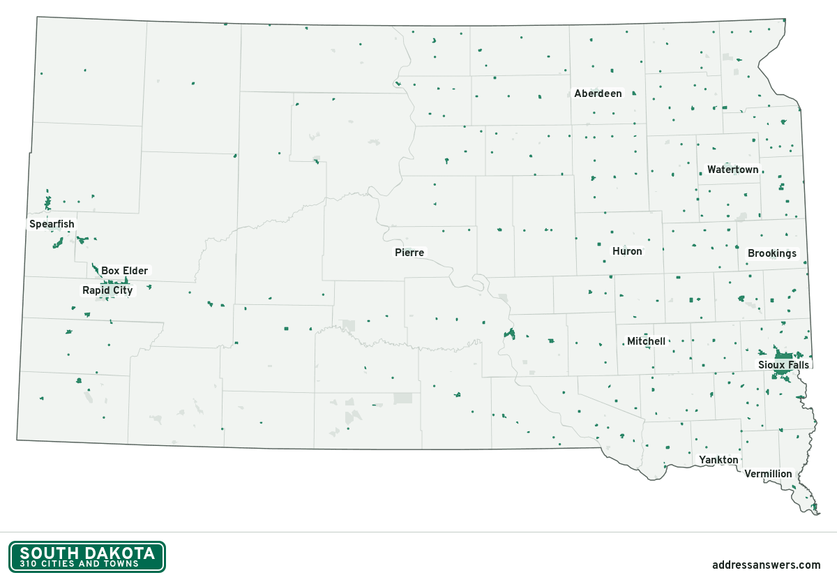
South Dakota city limits map image
The map above as a picture: every South Dakota city and town in green, with county lines. Boundaries from the Census Bureau, as of January 1, 2025.
You’re welcome to use it in a document or on your own site, with a link back to this page.
Download the map (PNG, 1,200 × 834)Questions about South Dakota city limits
How many cities and towns are in South Dakota?
South Dakota has 310 incorporated places: 157 cities, 152 towns, and 1 village, by the Census Bureau’s boundary files for 2025.
What is the largest city in South Dakota?
By population, Sioux Falls, with about 201,469 residents (2020–2024 American Community Survey 5-year estimates). It is also the largest by land area, at 84.5 square miles.
What is the smallest town in South Dakota?
By the Census Bureau’s estimate, Lowry, with 1 resident. Estimates for places this small have a wide margin of error, so treat it as a rough count.
How much of South Dakota is unincorporated?
99.3% of its land and 243,392 of its residents (27%) are outside every city or town. There, local government is the county. The state also has 175 named unincorporated communities; the largest is Rapid Valley.
Is Rapid Valley, SD a city?
No. Rapid Valley is a census-designated place: a community the Census Bureau maps for statistics, with no city government of its own. About 6,975 people live there, in unincorporated Pennington County. An address there is outside city limits, even if its mailing address says otherwise.
Is Dakota Dunes, SD a city?
No. Dakota Dunes is a census-designated place: a community the Census Bureau maps for statistics, with no city government of its own. About 3,936 people live there, in unincorporated Union County. An address there is outside city limits, even if its mailing address says otherwise.
Which cities and towns in South Dakota are in more than one county?
Nine of the 310 cross a county line, by at least 1% of their land. The largest: Sioux Falls (Minnehaha and Lincoln), Box Elder (Pennington and Meade), and Beresford (Union and Lincoln). Check an address to see which county it’s in.
Which county in South Dakota has the most cities and towns?
Minnehaha County, with 11 at least partly inside it. Buffalo County has none.
Bordering states
More answers for a South Dakota address
Each tool checks the same address and puts its own answer first.
- County Census Your county, plus the township or town where those exist. Find your county
- School district Census The public school district that covers the address. Find your school district
- Flood zone FEMA The FEMA zone in plain English, and whether lenders require flood insurance. Check flood zone
- USDA home loans USDA Whether the property is in an area eligible for a USDA Rural Development loan. Check USDA eligibility
- Voting districts Census Your congressional district and your state senate and state house districts. Included in every check
Places, boundaries, land area and counties: US Census Bureau 2025 cartographic boundary files (boundaries as of January 1, 2025). A place is listed in each county that holds at least 1% of its land. Population: 2020–2024 American Community Survey 5-year estimates. Data updated October 24, 2026; page updated October 25, 2026. Boundaries change through annexation; your city or county has the official map.