Michigan city limits map
Michigan has 533 incorporated places: 280 cities and 253 villages. They cover 4% of the state’s land and are home to 50% of its residents. Everyone else lives outside city limits, where local government is the township and the county. Enter an address to see which side of a city line it’s on.
Result for
The map couldn’t load. The answers don’t depend on it.
The boundary couldn’t load. The answer doesn’t depend on it.
Census Geocoder match
More about this address
Sources and limits
- Census
- US Census Bureau Geocoder, current boundaries
- FEMA
- National Flood Hazard Layer, effective flood maps
- USDA
- Rural Development property eligibility
- Map
- Boundaries from Census TIGERweb, flood zones drawn by FEMA, eligible areas from USDA, base map © OpenStreetMap contributors
Census boundaries are updated once a year, so a recent annexation may not show yet. Informational only, not an official determination. Verify with your city or county.
Michigan at a glance
- Incorporated places
- 533
- 280 cities and 253 villages
- Residents in city limits
- 50%
- 5,085,691 of 10,077,761
- Land in city limits
- 4%
- 2,244 of 56,613 sq mi
- Counties
- 83
- 1 with no city or village
- Unincorporated communities
- 212
- Largest: Forest Hills (28,695)
- Largest city
- Detroit
- 638,530 residents
How local government works in Michigan
Outside its cities and villages, Michigan is divided into 1,240 townships, 118 of them charter townships. Townships elect their own boards and handle services such as elections and property assessment, but they aren’t cities: an address in a township is outside city limits.
City limits maps for 7 Michigan cities
Every Michigan city with 100,000 or more residents has its own page: the boundary in detail, the places around it and its school districts.
All 533 cities and villages in Michigan
Every incorporated place, largest first, with the counties it’s in and its size. An address inside one of these is inside city limits; anywhere else in the state is unincorporated.
| Name | Type | County | Population | Land (sq mi) |
|---|---|---|---|---|
| Detroit | City | Wayne | 638,530 | 138.7 |
| Grand Rapids | City | Kent | 198,535 | 44.8 |
| Warren | City | Macomb | 137,928 | 34.4 |
| Sterling Heights | City | Macomb | 133,573 | 36.4 |
| Ann Arbor | City | Washtenaw | 122,036 | 28.4 |
| Lansing | City | Ingham, Eaton +1 | 113,023 | 39.4 |
| Dearborn | City | Wayne | 107,423 | 24.2 |
| Livonia | City | Wayne | 93,851 | 35.7 |
| Troy | City | Oakland | 87,898 | 33.4 |
| Westland | City | Wayne | 83,633 | 20.4 |
| Farmington Hills | City | Oakland | 83,515 | 33.3 |
| Flint | City | Genesee | 80,175 | 33.4 |
| Wyoming | City | Kent | 77,353 | 24.7 |
| Rochester Hills | City | Oakland | 77,089 | 32.8 |
| Southfield | City | Oakland | 76,236 | 26.3 |
| Kalamazoo | City | Kalamazoo | 73,076 | 24.6 |
| Novi | City | Oakland | 66,717 | 30.2 |
| Pontiac | City | Oakland | 62,104 | 19.9 |
| Taylor | City | Wayne | 62,081 | 23.6 |
| Dearborn Heights | City | Wayne | 61,771 | 11.7 |
| St. Clair Shores | City | Macomb | 58,140 | 11.7 |
| Royal Oak | City | Oakland | 57,950 | 11.8 |
| Kentwood | City | Kent | 54,296 | 20.9 |
| Battle Creek | City | Calhoun | 52,374 | 42.6 |
| Portage | City | Kalamazoo | 49,259 | 32.2 |
| Roseville | City | Macomb | 47,123 | 9.84 |
| East Lansing | City | Ingham, Clinton | 45,758 | 13.4 |
| Saginaw | City | Saginaw | 43,536 | 17.4 |
| Midland | City | Midland, Bay | 42,724 | 34.5 |
| Lincoln Park | City | Wayne | 39,257 | 5.84 |
| Muskegon | City | Muskegon | 37,226 | 14.1 |
| Holland | City | Ottawa, Allegan | 34,423 | 16.9 |
| Eastpointe | City | Macomb | 33,982 | 5.16 |
| Bay City | City | Bay | 32,320 | 10.2 |
| Jackson | City | Jackson | 31,058 | 10.8 |
| Burton | City | Genesee | 29,500 | 23.4 |
| Southgate | City | Wayne | 29,366 | 6.87 |
| Oak Park | City | Oakland | 29,318 | 5.15 |
| Port Huron | City | St. Clair | 28,620 | 8.10 |
| Madison Heights | City | Oakland | 28,419 | 7.09 |
| Allen Park | City | Wayne | 27,925 | 6.99 |
| Hamtramck | City | Wayne | 27,743 | 2.09 |
| Garden City | City | Wayne | 26,739 | 5.86 |
| Inkster | City | Wayne | 25,428 | 6.25 |
| Walker | City | Kent | 25,386 | 24.6 |
| Auburn Hills | City | Oakland | 25,105 | 16.6 |
| Norton Shores | City | Muskegon | 25,041 | 23.2 |
| Romulus | City | Wayne | 24,831 | 35.6 |
| Wyandotte | City | Wayne | 24,489 | 5.29 |
| Birmingham | City | Oakland | 21,763 | 4.79 |
| Marquette | City | Marquette | 21,325 | 11.3 |
| Mount Pleasant | City | Isabella | 21,236 | 7.72 |
| Adrian | City | Lenawee | 20,395 | 8.01 |
| Monroe | City | Monroe | 20,320 | 9.05 |
| Ypsilanti | City | Washtenaw | 19,857 | 4.29 |
| Ferndale | City | Oakland | 19,190 | 3.88 |
| Trenton | City | Wayne | 18,125 | 7.24 |
| Wayne | City | Wayne | 17,310 | 6.02 |
| Wixom | City | Oakland | 17,295 | 9.14 |
| Grandville | City | Kent | 16,356 | 7.25 |
| Grosse Pointe Woods | City | Wayne | 16,094 | 3.24 |
| Traverse City | City | Grand Traverse, Leelanau | 15,593 | 8.28 |
| Mount Clemens | City | Macomb | 15,511 | 4.09 |
| Berkley | City | Oakland | 15,149 | 2.61 |
| Harper Woods | City | Wayne | 15,116 | 2.63 |
| Hazel Park | City | Oakland | 14,963 | 2.82 |
| Owosso | City | Shiawassee | 14,632 | 5.25 |
| Fraser | City | Macomb | 14,583 | 4.14 |
| Coldwater | City | Branch | 13,671 | 9.42 |
| Sault Ste. Marie | City | Chippewa | 13,335 | 14.8 |
| Rochester | City | Oakland | 12,934 | 3.83 |
| Ionia | City | Ionia | 12,753 | 5.41 |
| Woodhaven | City | Wayne | 12,690 | 6.39 |
| Melvindale | City | Wayne | 12,554 | 2.73 |
| Escanaba | City | Delta | 12,354 | 12.7 |
| Riverview | City | Wayne | 12,186 | 4.57 |
| New Baltimore | City | Macomb | 12,072 | 4.60 |
| South Lyon | City | Oakland | 11,950 | 3.74 |
| Fenton | City | Genesee, Livingston | 11,906 | 6.65 |
| Niles | City | Berrien, Cass | 11,803 | 5.79 |
| Farmington | City | Oakland | 11,504 | 2.66 |
| East Grand Rapids | City | Kent | 11,445 | 2.93 |
| Clawson | City | Oakland | 11,374 | 2.20 |
| Grosse Pointe Park | City | Wayne | 11,319 | 2.17 |
| Sturgis | City | St. Joseph | 11,054 | 6.95 |
| Grand Haven | City | Ottawa | 10,996 | 5.72 |
| Beverly Hills | Village | Oakland | 10,524 | 4.02 |
| Cadillac | City | Wexford | 10,445 | 8.32 |
| Flat Rock | City | Wayne | 10,340 | 6.57 |
| Alpena | City | Alpena | 10,154 | 8.17 |
| Howell | City | Livingston | 10,021 | 4.99 |
| Marysville | City | St. Clair | 9,925 | 7.33 |
| Grosse Pointe Farms | City | Wayne | 9,904 | 2.73 |
| Muskegon Heights | City | Muskegon | 9,841 | 3.19 |
| Alma | City | Gratiot | 9,396 | 6.02 |
| Charlotte | City | Eaton | 9,277 | 6.45 |
| Plymouth | City | Wayne | 9,214 | 2.21 |
| Lapeer | City | Lapeer | 9,082 | 7.35 |
| Ecorse | City | Wayne | 9,064 | 2.84 |
| Saline | City | Washtenaw | 9,006 | 4.35 |
| Greenville | City | Montcalm | 8,995 | 6.34 |
| Benton Harbor | City | Berrien | 8,953 | 4.39 |
| Tecumseh | City | Lenawee | 8,646 | 5.65 |
| Highland Park | City | Wayne | 8,628 | 2.97 |
| Big Rapids | City | Mecosta | 8,477 | 4.45 |
| Houghton | City | Houghton | 8,474 | 4.46 |
| Center Line | City | Macomb | 8,463 | 1.75 |
| Menominee | City | Menominee | 8,326 | 5.16 |
| Flushing | City | Genesee | 8,284 | 3.61 |
| Mason | City | Ingham | 8,249 | 5.11 |
| Hillsdale | City | Hillsdale | 8,002 | 5.71 |
| Grand Blanc | City | Genesee | 7,987 | 3.61 |
| St. Joseph | City | Berrien | 7,986 | 3.20 |
| Three Rivers | City | St. Joseph | 7,943 | 5.59 |
| Grand Ledge | City | Eaton, Clinton | 7,804 | 3.91 |
| Hudsonville | City | Ottawa | 7,769 | 4.12 |
| St. Johns | City | Clinton | 7,715 | 4.21 |
| Brighton | City | Livingston | 7,688 | 3.51 |
| Ludington | City | Mason | 7,676 | 3.36 |
| Albion | City | Calhoun | 7,560 | 4.41 |
| Hastings | City | Barry | 7,520 | 5.21 |
| Iron Mountain | City | Dickinson | 7,518 | 7.54 |
| St. Louis | City | Gratiot | 7,367 | 3.30 |
| Walled Lake | City | Oakland | 7,299 | 2.21 |
| River Rouge | City | Wayne | 7,008 | 2.67 |
| Marshall | City | Calhoun | 6,804 | 8.83 |
| Milford | Village | Oakland | 6,487 | 2.45 |
| New Haven | Village | Macomb | 6,475 | 2.53 |
| Huntington Woods | City | Oakland | 6,328 | 1.49 |
| Manistee | City | Manistee | 6,275 | 3.28 |
| Rockford | City | Kent | 6,218 | 3.22 |
| Ishpeming | City | Marquette | 6,181 | 8.75 |
| Northville | City | Wayne, Oakland | 6,069 | 2.04 |
| Milan | City | Monroe, Washtenaw | 5,987 | 3.48 |
| Holly | Village | Oakland | 5,964 | 2.83 |
| Belding | City | Ionia | 5,960 | 4.72 |
| Petoskey | City | Emmet | 5,856 | 5.15 |
| Richmond | City | Macomb, St. Clair | 5,855 | 2.89 |
| Swartz Creek | City | Genesee | 5,853 | 4.19 |
| Dundee | Village | Monroe | 5,744 | 5.26 |
| Dowagiac | City | Cass | 5,732 | 4.45 |
| Zeeland | City | Ottawa | 5,665 | 2.99 |
| St. Clair | City | St. Clair | 5,585 | 2.94 |
| Grosse Pointe | City | Wayne | 5,541 | 1.06 |
| Chelsea | City | Washtenaw | 5,426 | 3.62 |
| Springfield | City | Calhoun | 5,269 | 3.63 |
| Gladstone | City | Delta | 5,253 | 5.07 |
| Eaton Rapids | City | Eaton | 5,183 | 3.63 |
| Utica | City | Macomb | 5,180 | 1.76 |
| Allegan | City | Allegan | 5,172 | 3.85 |
| Frankenmuth | City | Saginaw | 5,157 | 3.14 |
| Kingsford | City | Dickinson | 5,124 | 4.32 |
| Davison | City | Genesee | 5,076 | 1.99 |
| Ironwood | City | Gogebic | 4,997 | 6.58 |
| Gibraltar | City | Wayne | 4,873 | 3.69 |
| Coopersville | City | Ottawa | 4,848 | 4.81 |
| Cheboygan | City | Cheboygan | 4,820 | 6.86 |
| DeWitt | City | Clinton | 4,777 | 2.84 |
| Negaunee | City | Marquette | 4,656 | 13.4 |
| Hancock | City | Houghton | 4,574 | 2.78 |
| Fremont | City | Newaygo | 4,568 | 3.60 |
| Dexter | City | Washtenaw | 4,521 | 1.94 |
| Wolverine Lake | Village | Oakland | 4,487 | 1.26 |
| Wayland | City | Allegan | 4,457 | 2.96 |
| Bloomfield Hills | City | Oakland | 4,415 | 4.96 |
| Middleville | Village | Barry | 4,380 | 2.44 |
| Gaylord | City | Otsego | 4,357 | 5.20 |
| Caro | City | Tuscola | 4,290 | 2.94 |
| Sparta | Village | Kent | 4,271 | 2.55 |
| Buchanan | City | Berrien | 4,223 | 2.52 |
| Linden | City | Genesee | 4,160 | 2.35 |
| Roosevelt Park | City | Muskegon | 4,144 | 1.03 |
| Algonac | City | St. Clair | 4,139 | 1.42 |
| Lowell | City | Kent | 4,139 | 2.88 |
| North Muskegon | City | Muskegon | 4,098 | 1.80 |
| Otsego | City | Allegan | 4,074 | 2.03 |
| Lathrup Village | City | Oakland | 4,059 | 1.51 |
| Marine City | City | St. Clair | 4,028 | 2.16 |
| South Haven | City | Van Buren | 3,998 | 3.46 |
| Vicksburg | Village | Kalamazoo | 3,934 | 2.96 |
| Belleville | City | Wayne | 3,910 | 1.13 |
| Boyne City | City | Charlevoix | 3,825 | 4.04 |
| Williamston | City | Ingham | 3,807 | 2.45 |
| Portland | City | Ionia | 3,790 | 2.63 |
| Plainwell | City | Allegan | 3,763 | 2.08 |
| Imlay City | City | Lapeer | 3,721 | 2.45 |
| Cedar Springs | City | Kent | 3,670 | 2.02 |
| Romeo | Village | Macomb | 3,578 | 2.16 |
| Durand | City | Shiawassee | 3,483 | 1.95 |
| Oxford | Village | Oakland | 3,474 | 1.26 |
| Essexville | City | Bay | 3,327 | 1.29 |
| Clare | City | Clare, Isabella | 3,324 | 3.75 |
| Paw Paw | Village | Van Buren | 3,289 | 2.67 |
| Blissfield | Village | Lenawee | 3,234 | 2.25 |
| Rockwood | City | Wayne | 3,161 | 2.52 |
| Mount Morris | City | Genesee | 3,117 | 1.15 |
| Gladwin | City | Gladwin | 3,098 | 2.88 |
| Potterville | City | Eaton | 3,087 | 1.75 |
| Corunna | City | Shiawassee | 3,037 | 3.18 |
| Whitehall | City | Muskegon | 3,024 | 3.22 |
| Iron River | City | Iron | 3,002 | 6.74 |
| Bad Axe | City | Huron | 2,992 | 2.34 |
| Ferrysburg | City | Ottawa | 2,959 | 2.99 |
| Fowlerville | Village | Livingston | 2,918 | 2.31 |
| Rogers City | City | Presque Isle | 2,878 | 4.53 |
| Lake Orion | Village | Oakland | 2,863 | 0.79 |
| Manistique | City | Schoolcraft | 2,863 | 3.21 |
| Almont | Village | Lapeer | 2,838 | 1.35 |
| Norway | City | Dickinson | 2,833 | 9.47 |
| Ithaca | City | Gratiot | 2,817 | 5.72 |
| Village of Grosse Pointe Shores | City | Wayne, Macomb | 2,795 | 1.11 |
| Keego Harbor | City | Oakland | 2,747 | 0.50 |
| Vassar | City | Tuscola | 2,707 | 2.15 |
| Sandusky | City | Sanilac | 2,694 | 2.15 |
| Mattawan | Village | Van Buren | 2,692 | 3.81 |
| East Tawas | City | Iosco | 2,675 | 2.81 |
| Pleasant Ridge | City | Oakland | 2,602 | 0.57 |
| Carleton | Village | Monroe | 2,595 | 0.99 |
| Shelby | Village | Oceana | 2,577 | 1.73 |
| Franklin | Village | Oakland | 2,554 | 2.66 |
| Kalkaska | Village | Kalkaska | 2,539 | 2.64 |
| Clinton | Village | Lenawee | 2,536 | 1.83 |
| Montague | City | Muskegon | 2,531 | 2.63 |
| Manchester | Village | Washtenaw | 2,522 | 2.14 |
| Spring Lake | Village | Ottawa | 2,519 | 1.25 |
| Reed City | City | Osceola | 2,517 | 2.10 |
| Newaygo | City | Newaygo | 2,512 | 3.77 |
| Croswell | City | Sanilac | 2,488 | 2.36 |
| Chesaning | Village | Saginaw | 2,484 | 3.07 |
| St. Ignace | City | Mackinac | 2,463 | 2.64 |
| Hartford | City | Van Buren | 2,458 | 1.36 |
| Charlevoix | City | Charlevoix | 2,392 | 2.06 |
| Jonesville | City | Hillsdale | 2,319 | 2.79 |
| Orchard Lake Village | City | Oakland | 2,238 | 2.40 |
| West Branch | City | Ogemaw | 2,225 | 1.54 |
| Cass City | Village | Tuscola | 2,210 | 1.78 |
| Hudson | City | Lenawee | 2,200 | 2.19 |
| Clio | City | Genesee | 2,185 | 1.11 |
| Watervliet | City | Berrien | 2,156 | 1.18 |
| Lake Odessa | Village | Ionia | 2,155 | 0.89 |
| Constantine | Village | St. Joseph | 2,154 | 1.64 |
| Morenci | City | Lenawee | 2,137 | 2.12 |
| Bangor | City | Van Buren | 2,129 | 1.77 |
| Leslie | City | Ingham | 2,129 | 1.28 |
| Yale | City | St. Clair | 2,129 | 1.37 |
| Auburn | City | Bay | 2,124 | 1.06 |
| Harrison | City | Clare | 2,110 | 3.72 |
| Lawton | Village | Van Buren | 2,104 | 2.29 |
| Lake Isabella | Village | Isabella | 2,085 | 3.48 |
| Bronson | City | Branch | 2,083 | 1.37 |
| Bridgman | City | Berrien | 2,077 | 2.89 |
| Perry | City | Shiawassee | 2,073 | 2.60 |
| Montrose | City | Genesee | 2,027 | 0.98 |
| East Jordan | City | Charlevoix | 2,023 | 3.00 |
| Galesburg | City | Kalamazoo | 2,023 | 1.42 |
| Goodrich | Village | Genesee | 2,022 | 2.20 |
| Berrien Springs | Village | Berrien | 2,018 | 0.92 |
| Saranac | Village | Ionia | 2,013 | 1.15 |
| Parchment | City | Kalamazoo | 2,008 | 0.92 |
| Armada | Village | Macomb | 1,994 | 0.74 |
| Munising | City | Alger | 1,975 | 5.26 |
| Capac | Village | St. Clair | 1,970 | 1.87 |
| Union City | Village | Branch, Calhoun | 1,940 | 1.44 |
| Baraga | Village | Baraga | 1,939 | 2.38 |
| St. Charles | Village | Saginaw | 1,934 | 2.09 |
| Hart | City | Oceana | 1,924 | 1.79 |
| South Rockwood | Village | Monroe | 1,924 | 3.27 |
| Pinckney | Village | Livingston | 1,911 | 1.61 |
| Marlette | City | Sanilac | 1,850 | 1.61 |
| Sebewaing | Village | Huron | 1,850 | 1.59 |
| Olivet | City | Eaton | 1,844 | 1.02 |
| Decatur | Village | Van Buren | 1,835 | 1.35 |
| Cassopolis | Village | Cass | 1,834 | 2.01 |
| L'Anse | Village | Baraga | 1,790 | 2.61 |
| Kingsley | Village | Grand Traverse | 1,785 | 1.33 |
| Laingsburg | City | Shiawassee | 1,769 | 1.59 |
| White Pigeon | Village | St. Joseph | 1,760 | 1.41 |
| Bessemer | City | Gogebic | 1,733 | 5.50 |
| Crystal Falls | City | Iron | 1,719 | 3.49 |
| Sylvan Lake | City | Oakland | 1,705 | 0.52 |
| Wakefield | City | Gogebic | 1,683 | 7.87 |
| Bingham Farms | Village | Oakland | 1,680 | 1.21 |
| Caledonia | Village | Kent | 1,671 | 1.34 |
| Grayling | City | Crawford | 1,671 | 2.05 |
| Evart | City | Osceola | 1,667 | 2.46 |
| Howard City | Village | Montcalm | 1,636 | 2.41 |
| Elk Rapids | Village | Antrim | 1,624 | 1.65 |
| Fennville | City | Allegan | 1,623 | 1.12 |
| Tawas City | City | Iosco | 1,614 | 1.70 |
| Homer | Village | Calhoun | 1,610 | 1.40 |
| Zilwaukee | City | Saginaw | 1,609 | 2.21 |
| Harbor Beach | City | Huron | 1,582 | 1.72 |
| Colon | Village | St. Joseph | 1,570 | 1.37 |
| Litchfield | City | Hillsdale | 1,566 | 2.78 |
| Centreville | Village | St. Joseph | 1,565 | 1.44 |
| Standish | City | Arenac | 1,554 | 2.18 |
| Bellevue | Village | Eaton | 1,552 | 1.02 |
| Morrice | Village | Shiawassee | 1,550 | 1.30 |
| Ravenna | Village | Muskegon | 1,540 | 1.19 |
| Dimondale | Village | Eaton | 1,521 | 0.89 |
| Breckenridge | Village | Gratiot | 1,517 | 1.23 |
| Edmore | Village | Montcalm | 1,514 | 1.52 |
| Manton | City | Wexford | 1,511 | 1.56 |
| Laurium | Village | Houghton | 1,509 | 0.65 |
| Nashville | Village | Barry | 1,503 | 2.11 |
| Three Oaks | Village | Berrien | 1,503 | 1.09 |
| Quincy | Village | Branch | 1,484 | 1.56 |
| Mancelona | Village | Antrim | 1,476 | 1.00 |
| Scottville | City | Mason | 1,474 | 1.49 |
| Edwardsburg | Village | Cass | 1,472 | 0.91 |
| Shepherd | Village | Isabella | 1,457 | 0.96 |
| Pinconning | City | Bay | 1,448 | 0.86 |
| Birch Run | Village | Saginaw | 1,439 | 1.89 |
| Douglas | City | Allegan | 1,427 | 1.78 |
| Fowler | Village | Clinton | 1,387 | 1.28 |
| Stockbridge | Village | Ingham | 1,383 | 1.50 |
| Webberville | Village | Ingham | 1,375 | 1.84 |
| Ovid | City | Clinton, Shiawassee | 1,370 | 1.01 |
| Ontonagon | Village | Ontonagon | 1,355 | 3.68 |
| Ortonville | Village | Oakland | 1,341 | 0.96 |
| New Buffalo | City | Berrien | 1,338 | 2.47 |
| Newberry | Village | Luce | 1,329 | 0.98 |
| Stanton | City | Montcalm | 1,285 | 2.15 |
| White Cloud | City | Newaygo | 1,280 | 1.93 |
| Schoolcraft | Village | Kalamazoo | 1,275 | 0.98 |
| Reese | Village | Tuscola, Saginaw | 1,274 | 1.35 |
| Baldwin | Village | Lake | 1,261 | 1.27 |
| Lakewood Club | Village | Muskegon | 1,255 | 1.91 |
| Luna Pier | City | Monroe | 1,244 | 1.49 |
| Carson City | City | Montcalm | 1,233 | 1.14 |
| Frankfort | City | Benzie | 1,225 | 1.39 |
| Fruitport | Village | Muskegon | 1,212 | 0.91 |
| Coleman | City | Midland | 1,206 | 1.27 |
| Kent City | Village | Kent | 1,203 | 1.36 |
| Grass Lake | Village | Jackson | 1,186 | 0.94 |
| Dryden | Village | Lapeer | 1,182 | 1.10 |
| Brooklyn | Village | Jackson | 1,180 | 1.02 |
| Petersburg | City | Monroe | 1,179 | 0.48 |
| North Branch | Village | Lapeer | 1,166 | 1.44 |
| Onsted | Village | Lenawee | 1,155 | 1.07 |
| Brown City | City | Sanilac, Lapeer | 1,139 | 1.13 |
| Athens | Village | Calhoun | 1,134 | 1.00 |
| Lexington | Village | Sanilac | 1,126 | 1.38 |
| Millington | Village | Tuscola | 1,122 | 1.36 |
| Concord | Village | Jackson | 1,118 | 1.50 |
| Roscommon | Village | Roscommon | 1,118 | 1.65 |
| Marcellus | Village | Cass | 1,112 | 0.90 |
| Pigeon | Village | Huron | 1,100 | 0.80 |
| Shoreham | Village | Berrien | 1,100 | 0.59 |
| Richland | Village | Kalamazoo | 1,098 | 1.01 |
| Grant | City | Newaygo | 1,096 | 0.67 |
| Stevensville | Village | Berrien | 1,095 | 1.04 |
| Harbor Springs | City | Emmet | 1,086 | 1.30 |
| Coloma | City | Berrien | 1,074 | 0.89 |
| Memphis | City | Macomb, St. Clair | 1,064 | 1.12 |
| Beaverton | City | Gladwin | 1,061 | 1.06 |
| Central Lake | Village | Antrim | 1,051 | 0.98 |
| Mayville | Village | Tuscola | 1,045 | 1.08 |
| Deckerville | Village | Sanilac | 1,042 | 1.25 |
| Lakeview | Village | Montcalm | 1,030 | 1.51 |
| Lake Linden | Village | Houghton | 1,020 | 0.79 |
| Au Gres | City | Arenac | 1,018 | 2.28 |
| Bellaire | Village | Antrim | 1,008 | 1.91 |
| Elsie | Village | Clinton | 1,000 | 1.14 |
| Otisville | Village | Genesee | 988 | 0.88 |
| Westphalia | Village | Clinton | 980 | 1.11 |
| Farwell | Village | Clare | 974 | 1.37 |
| Reading | City | Hillsdale | 947 | 1.01 |
| Lawrence | Village | Van Buren | 942 | 1.78 |
| Buckley | Village | Wexford | 936 | 1.82 |
| Hesperia | Village | Oceana, Newaygo | 934 | 0.82 |
| Stephenson | City | Menominee | 902 | 1.09 |
| Lyons | Village | Ionia | 896 | 1.22 |
| Village of Clarkston | City | Oakland | 874 | 0.44 |
| Pentwater | Village | Oceana | 872 | 1.34 |
| Springport | Village | Jackson | 871 | 1.26 |
| Deerfield | Village | Lenawee | 860 | 0.95 |
| Baroda | Village | Berrien | 859 | 0.72 |
| Alanson | Village | Emmet | 834 | 0.98 |
| Burr Oak | Village | St. Joseph | 818 | 1.01 |
| Mendon | Village | St. Joseph | 815 | 0.98 |
| Hillman | Village | Montmorency, Alpena | 812 | 1.66 |
| Port Sanilac | Village | Sanilac | 812 | 0.85 |
| Merrill | Village | Saginaw | 798 | 0.69 |
| Vermontville | Village | Eaton | 790 | 1.27 |
| Ubly | Village | Huron | 785 | 1.32 |
| Mackinaw City | Village | Emmet, Cheboygan | 778 | 3.44 |
| Augusta | Village | Kalamazoo | 776 | 1.02 |
| Hopkins | Village | Allegan | 773 | 0.48 |
| Saugatuck | City | Allegan | 766 | 1.39 |
| Pellston | Village | Emmet | 755 | 1.95 |
| Columbiaville | Village | Lapeer | 754 | 0.97 |
| Elkton | Village | Huron | 750 | 1.00 |
| Sheridan | Village | Montcalm | 746 | 1.10 |
| New Lothrop | Village | Shiawassee | 733 | 0.87 |
| Maple Rapids | Village | Clinton | 727 | 1.37 |
| Climax | Village | Kalamazoo | 723 | 1.06 |
| Benzonia | Village | Benzie | 718 | 1.13 |
| Sanford | Village | Midland | 716 | 1.27 |
| McBain | City | Missaukee | 706 | 1.26 |
| Lake City | City | Missaukee | 705 | 1.05 |
| Port Austin | Village | Huron | 699 | 0.99 |
| Vernon | Village | Shiawassee | 697 | 1.00 |
| Metamora | Village | Lapeer | 693 | 0.83 |
| Onaway | City | Presque Isle | 674 | 1.63 |
| Sunfield | Village | Eaton | 658 | 0.76 |
| Britton | Village | Lenawee | 652 | 0.79 |
| Calumet | Village | Houghton | 645 | 0.20 |
| Caseville | City | Huron | 634 | 1.12 |
| Maybee | Village | Monroe | 634 | 1.84 |
| Cement City | Village | Lenawee, Jackson | 629 | 0.89 |
| Morley | Village | Mecosta | 624 | 0.89 |
| Parma | Village | Jackson | 624 | 1.05 |
| Byron | Village | Shiawassee | 617 | 0.71 |
| Camden | Village | Hillsdale | 608 | 0.80 |
| Waldron | Village | Hillsdale | 603 | 1.00 |
| Caspian | City | Iron | 600 | 1.43 |
| Dansville | Village | Ingham | 599 | 1.01 |
| Gobles | City | Van Buren | 595 | 1.03 |
| Peck | Village | Sanilac | 589 | 1.04 |
| Marion | Village | Osceola | 581 | 1.29 |
| Martin | Village | Allegan | 579 | 0.77 |
| Eau Claire | Village | Berrien | 576 | 0.89 |
| Rose City | City | Ogemaw | 575 | 1.08 |
| Tekonsha | Village | Calhoun | 575 | 0.99 |
| Unionville | Village | Tuscola | 569 | 0.94 |
| Mackinac Island | City | Mackinac | 561 | 4.35 |
| Suttons Bay | Village | Leelanau | 555 | 1.28 |
| Gaines | Village | Genesee | 552 | 0.37 |
| Fairgrove | Village | Tuscola | 547 | 1.12 |
| Kaleva | Village | Manistee | 542 | 1.11 |
| Addison | Village | Lenawee | 534 | 0.96 |
| Freeport | Village | Barry | 523 | 0.79 |
| Bloomingdale | Village | Van Buren | 522 | 1.14 |
| Perrinton | Village | Gratiot | 513 | 0.63 |
| Mulliken | Village | Eaton | 501 | 1.04 |
| Whittemore | City | Iosco | 492 | 1.02 |
| Muir | Village | Ionia | 490 | 0.71 |
| Thompsonville | Village | Benzie | 490 | 1.00 |
| Harrisville | City | Alcona | 489 | 0.63 |
| Woodland | Village | Barry | 488 | 0.85 |
| Sand Lake | Village | Kent | 484 | 0.71 |
| Ashley | Village | Gratiot | 483 | 0.78 |
| South Range | Village | Houghton | 482 | 0.36 |
| Galien | Village | Berrien | 470 | 0.41 |
| Bancroft | Village | Shiawassee | 469 | 0.54 |
| Lennon | Village | Shiawassee, Genesee | 465 | 0.91 |
| Northport | Village | Leelanau | 465 | 1.65 |
| Hubbardston | Village | Ionia, Clinton | 464 | 1.45 |
| Mecosta | Village | Mecosta | 464 | 1.11 |
| Carsonville | Village | Sanilac | 463 | 1.16 |
| Sterling | Village | Arenac | 448 | 0.98 |
| Pewamo | Village | Ionia | 439 | 1.00 |
| North Adams | Village | Hillsdale | 435 | 0.53 |
| New Era | Village | Oceana | 433 | 0.84 |
| Barton Hills | Village | Washtenaw | 430 | 0.81 |
| Mesick | Village | Wexford | 423 | 1.33 |
| Clarksville | Village | Ionia | 417 | 0.50 |
| Kinde | Village | Huron | 414 | 1.18 |
| Kingston | Village | Tuscola | 398 | 1.02 |
| Barryton | Village | Mecosta | 394 | 0.96 |
| Sherwood | Village | Branch | 388 | 1.00 |
| Otter Lake | Village | Lapeer, Genesee | 379 | 0.76 |
| Casnovia | Village | Kent, Muskegon | 377 | 1.06 |
| Hanover | Village | Jackson | 375 | 0.42 |
| Estral Beach | Village | Monroe | 372 | 0.44 |
| Vandalia | Village | Cass | 366 | 0.99 |
| Boyne Falls | Village | Charlevoix | 361 | 0.56 |
| Hersey | Village | Osceola | 360 | 1.10 |
| Powers | Village | Menominee | 360 | 0.94 |
| Rothbury | Village | Oceana | 356 | 2.46 |
| Grand Beach | Village | Berrien | 353 | 0.91 |
| Leonard | Village | Oakland | 346 | 0.99 |
| Posen | Village | Presque Isle | 345 | 1.00 |
| Fife Lake | Village | Grand Traverse | 343 | 0.73 |
| Empire | Village | Leelanau | 341 | 1.03 |
| Vanderbilt | Village | Otsego | 341 | 1.09 |
| Akron | Village | Tuscola | 336 | 0.94 |
| Rosebush | Village | Isabella | 331 | 0.89 |
| Eastlake | Village | Manistee | 318 | 1.20 |
| Gagetown | Village | Tuscola | 311 | 0.98 |
| Onekama | Village | Manistee | 305 | 0.59 |
| Luther | Village | Lake | 303 | 0.97 |
| Montgomery | Village | Hillsdale | 301 | 1.00 |
| Gaastra | City | Iron | 296 | 1.64 |
| Michiana | Village | Berrien | 291 | 0.37 |
| Breedsville | Village | Van Buren | 288 | 0.65 |
| Omer | City | Arenac | 283 | 1.13 |
| Clifford | Village | Lapeer | 277 | 1.51 |
| Custer | Village | Mason | 275 | 1.07 |
| Lake Ann | Village | Benzie | 273 | 0.45 |
| Prescott | Village | Ogemaw | 270 | 1.11 |
| Port Hope | Village | Huron | 268 | 1.01 |
| Ellsworth | Village | Antrim | 265 | 0.75 |
| Wolverine | Village | Cheboygan | 265 | 0.98 |
| Bear Lake | Village | Manistee | 264 | 0.31 |
| Burlington | Village | Calhoun | 264 | 0.76 |
| Oakley | Village | Saginaw | 257 | 1.03 |
| Applegate | Village | Sanilac | 255 | 1.00 |
| Copemish | Village | Manistee | 255 | 0.93 |
| Copper City | Village | Houghton | 253 | 0.08 |
| Clayton | Village | Lenawee | 247 | 0.75 |
| Lake Angelus | City | Oakland | 238 | 0.99 |
| Harrietta | Village | Wexford | 230 | 0.99 |
| Lincoln | Village | Alcona | 225 | 0.82 |
| Beulah | Village | Benzie | 218 | 0.41 |
| Alpha | Village | Iron | 215 | 0.94 |
| De Tour Village | Village | Chippewa | 212 | 3.53 |
| Emmett | Village | St. Clair | 207 | 1.50 |
| Fountain | Village | Mason | 204 | 1.03 |
| Minden City | Village | Sanilac | 203 | 0.99 |
| Tustin | Village | Osceola | 203 | 0.39 |
| Le Roy | Village | Osceola | 202 | 0.98 |
| Walkerville | Village | Oceana | 202 | 1.24 |
| McBride | Village | Montcalm | 195 | 0.39 |
| Owendale | Village | Huron | 193 | 0.74 |
| Twining | Village | Arenac | 192 | 0.97 |
| Carney | Village | Menominee | 177 | 1.37 |
| Daggett | Village | Menominee | 174 | 1.12 |
| Elberta | Village | Benzie | 174 | 0.75 |
| Honor | Village | Benzie | 172 | 0.54 |
| Allen | Village | Hillsdale | 170 | 0.17 |
| Stanwood | Village | Mecosta | 162 | 0.24 |
| Garden | Village | Delta | 154 | 0.83 |
| Melvin | Village | Sanilac | 139 | 0.97 |
| Millersburg | Village | Presque Isle | 137 | 0.99 |
| Forestville | Village | Sanilac | 136 | 0.79 |
| Chatham | Village | Alger | 135 | 2.45 |
| Pierson | Village | Montcalm | 119 | 0.25 |
| Free Soil | Village | Mason | 112 | 1.04 |
| Ahmeek | Village | Keweenaw | 93 | 0.07 |
| Eagle | Village | Clinton | 93 | 0.13 |
| Turner | Village | Arenac | 86 | 1.02 |
Showing 1–50 of 533
Unincorporated communities in Michigan
Census-designated places: named communities the Census Bureau maps for statistics, with no city government of their own. An address in one is outside city limits, even when its mailing address names a city. Michigan has 212.
| Community | County | Population | Land (sq mi) |
|---|---|---|---|
| Forest Hills | Kent | 28,695 | 49.3 |
| Allendale | Ottawa | 26,679 | 23.2 |
| Okemos | Ingham | 26,396 | 16.9 |
| Holt | Ingham | 25,316 | 15.7 |
| Waverly | Eaton | 23,575 | 9.10 |
| Cutlerville | Kent | 18,780 | 5.74 |
| Haslett | Ingham | 18,559 | 15.4 |
| Jenison | Ottawa | 17,582 | 5.85 |
| Northview | Kent | 15,268 | 10.3 |
| Comstock Park | Kent | 10,577 | 3.88 |
| Lambertville | Monroe | 9,955 | 6.74 |
| Temperance | Monroe | 8,914 | 4.61 |
| Westwood | Kalamazoo | 8,867 | 2.85 |
| Beecher | Genesee | 8,412 | 5.88 |
| Whitmore Lake | Washtenaw | 7,878 | 4.80 |
| Freeland | Saginaw | 7,557 | 6.59 |
| Byron Center | Kent | 7,403 | 5.08 |
| Shields | Saginaw | 7,402 | 7.88 |
| Fair Plain | Berrien | 7,330 | 4.30 |
| South Monroe | Monroe | 6,960 | 2.43 |
| Bridgeport | Saginaw | 6,884 | 8.40 |
| Eastwood | Kalamazoo | 6,669 | 1.98 |
| Lake Fenton | Genesee | 6,417 | 5.52 |
| Buena Vista | Saginaw | 5,798 | 4.00 |
| Houghton Lake | Roscommon | 5,769 | 10.8 |
| Comstock Northwest | Kalamazoo | 5,391 | 3.23 |
| Michigan Center | Jackson | 4,999 | 5.04 |
| Wolf Lake | Muskegon | 4,654 | 3.54 |
| Pearl Beach | St. Clair | 4,506 | 4.80 |
| Vandercook Lake | Jackson | 4,375 | 4.58 |
| Paw Paw Lake | Berrien | 3,889 | 5.13 |
| Dorr | Allegan | 3,702 | 3.22 |
| Level Park-Oak Park | Calhoun | 3,488 | 5.21 |
| Benton Heights | Berrien | 3,078 | 3.86 |
| Skidway Lake | Ogemaw | 3,008 | 11.3 |
| Canadian Lakes | Mecosta | 2,991 | 10.3 |
| St. Helen | Roscommon | 2,929 | 5.73 |
| Bath | Clinton | 2,896 | 5.86 |
| Harvey | Marquette | 2,880 | 6.74 |
| West Ishpeming | Marquette | 2,851 | 2.96 |
| K. I. Sawyer | Marquette | 2,817 | 1.71 |
| Beechwood | Ottawa | 2,776 | 1.81 |
| Detroit Beach | Monroe | 2,771 | 0.62 |
| West Monroe | Monroe | 2,711 | 1.25 |
| Edgemont Park | Ingham | 2,551 | 0.83 |
| Kincheloe | Chippewa | 2,524 | 1.27 |
| Trowbridge Park | Marquette | 2,396 | 1.39 |
| Spring Arbor | Jackson | 2,275 | 2.78 |
| Argentine | Genesee | 2,190 | 2.37 |
| Manitou Beach-Devils Lake | Lenawee | 2,103 | 6.08 |
| Indian River | Cheboygan | 2,039 | 12.9 |
| Twin Lake | Muskegon | 2,036 | 2.88 |
| Woodland Beach | Monroe | 1,919 | 0.52 |
| Stony Point | Monroe | 1,825 | 1.21 |
| South Gull Lake | Kalamazoo | 1,801 | 1.35 |
| Wacousta | Clinton | 1,711 | 8.91 |
| Brownlee Park | Calhoun | 1,661 | 2.02 |
| Lake LeAnn | Hillsdale | 1,657 | 1.66 |
| Au Sable | Iosco | 1,643 | 2.10 |
| Hemlock | Saginaw | 1,529 | 2.75 |
| Lakes of the North | Antrim | 1,524 | 16.6 |
| Greilickville | Leelanau | 1,519 | 4.59 |
| Mio | Oscoda | 1,474 | 8.37 |
| Shorewood-Tower Hills-Harbert | Berrien | 1,459 | 4.53 |
| Gwinn | Marquette | 1,435 | 2.81 |
| Prudenville | Roscommon | 1,350 | 2.85 |
| Sand Lake | Iosco | 1,348 | 14.9 |
| Burt | Saginaw | 1,339 | 6.04 |
| Rapid City | Kalkaska | 1,328 | 5.41 |
| Lewiston | Montmorency | 1,201 | 2.83 |
| Chums Corner | Grand Traverse | 1,186 | 2.66 |
| Lamont | Ottawa | 1,177 | 2.77 |
| Weidman | Isabella | 1,156 | 5.65 |
| Crystal | Montcalm | 1,114 | 2.76 |
| Fostoria | Tuscola | 1,050 | 4.01 |
| Ida | Monroe | 1,050 | 2.47 |
| Dollar Bay | Houghton | 1,049 | 3.93 |
| Vineyard Lake | Jackson | 1,031 | 2.56 |
| Ossineke | Alpena | 1,019 | 3.66 |
| Lake Victoria | Clinton | 1,006 | 0.82 |
| Barnes Lake | Lapeer | 952 | 1.55 |
| Hubbard Lake | Alcona | 944 | 8.74 |
| Delton | Barry | 936 | 2.22 |
| Hartland | Livingston | 912 | 2.28 |
| Presque Isle Harbor | Presque Isle | 906 | 6.37 |
| Chassell | Houghton | 899 | 3.61 |
| Quinnesec | Dickinson | 892 | 1.51 |
| Hubbell | Houghton | 881 | 1.87 |
| Lake Michigan Beach | Berrien | 823 | 3.83 |
| Grawn | Grand Traverse | 800 | 0.65 |
| Middletown | Shiawassee | 799 | 0.47 |
| Interlochen | Grand Traverse | 791 | 1.24 |
| Atlanta | Montmorency | 758 | 3.61 |
| Napoleon | Jackson | 745 | 2.62 |
| Lakeport | St. Clair | 742 | 1.03 |
| Ruby | St. Clair | 714 | 3.75 |
| Pittsford | Hillsdale | 707 | 1.91 |
| Bay Shore | Charlevoix | 697 | 1.55 |
| Hermansville | Menominee | 666 | 1.27 |
| Robin Glen-Indiantown | Saginaw | 660 | 2.81 |
| Oscoda | Iosco | 654 | 0.87 |
| Attica | Lapeer | 627 | 4.78 |
| Hardwood Acres | Benzie | 611 | 0.53 |
| Parkdale | Manistee | 573 | 1.55 |
| Trufant | Montcalm | 572 | 0.96 |
| Millburg | Berrien | 568 | 1.81 |
| Millers Lake | Lapeer | 554 | 1.51 |
| South Boardman | Kalkaska | 553 | 3.29 |
| Oak Hill | Manistee | 519 | 0.50 |
| Republic | Marquette | 519 | 3.62 |
| Cannonsburg | Kent | 510 | 0.42 |
| Atlantic Mine | Houghton | 491 | 1.10 |
| Bay Port | Huron | 474 | 3.35 |
| Lost Lake Woods | Alcona | 458 | 5.05 |
| Shaftsburg | Shiawassee | 441 | 1.00 |
| Painesdale | Houghton | 416 | 0.39 |
| New Troy | Berrien | 413 | 1.32 |
| Manistee Lake | Kalkaska | 412 | 3.57 |
| Dodgeville | Houghton | 409 | 0.54 |
| Leland | Leelanau | 400 | 0.98 |
| Canada Creek Ranch | Montmorency | 381 | 2.23 |
| Carp Lake | Emmet | 380 | 2.06 |
| Advance | Charlevoix | 377 | 2.72 |
| Palo | Ionia | 375 | 0.70 |
| Horton Bay | Charlevoix | 374 | 4.82 |
| White Pine | Ontonagon | 369 | 5.00 |
| Wellston | Manistee | 353 | 0.97 |
| Brimley | Chippewa | 345 | 1.75 |
| Bear Lake | Kalkaska | 343 | 5.76 |
| Zeba | Baraga | 342 | 3.61 |
| Glen Arbor | Leelanau | 336 | 1.03 |
| Henderson | Shiawassee | 320 | 3.60 |
| Brethren | Manistee | 318 | 1.28 |
| Bendon | Benzie | 315 | 2.00 |
| Ramsay | Gogebic | 312 | 0.60 |
| Eastport | Antrim | 311 | 2.00 |
| Palmer | Marquette | 309 | 0.59 |
| Big Bay | Marquette | 306 | 3.90 |
| Omena | Leelanau | 305 | 4.52 |
| Mass City | Ontonagon | 299 | 0.54 |
| Nunica | Ottawa | 295 | 1.83 |
| Walloon Lake | Charlevoix | 294 | 1.35 |
| Beal City | Isabella | 293 | 4.01 |
| Alba | Antrim | 282 | 2.73 |
| Jasper | Lenawee | 282 | 4.03 |
| Ewen | Ontonagon | 281 | 0.84 |
| Tower | Cheboygan | 275 | 0.54 |
| St. James | Charlevoix | 269 | 1.03 |
| Dowling | Barry | 267 | 6.08 |
| Mohawk | Keweenaw | 264 | 1.23 |
| Bruce Crossing | Ontonagon | 257 | 4.51 |
| Jennings | Missaukee | 254 | 0.76 |
| Amasa | Iron | 253 | 4.04 |
| Watersmeet | Gogebic | 250 | 9.20 |
| Rockland | Ontonagon | 246 | 0.44 |
| Wedgewood | Wexford | 241 | 0.62 |
| Conway | Emmet | 237 | 0.42 |
| Scotts | Kalamazoo | 237 | 0.24 |
| Michigamme | Marquette | 229 | 2.38 |
| Elm Hall | Gratiot | 228 | 1.40 |
| Winn | Isabella | 226 | 0.57 |
| Marenisco | Gogebic | 223 | 3.45 |
| Rapid River | Delta | 223 | 1.26 |
| Falmouth | Missaukee | 222 | 0.68 |
| Riverdale | Gratiot | 216 | 0.69 |
| Lupton | Ogemaw | 206 | 3.23 |
| Mears | Oceana | 204 | 1.14 |
| Paris | Mecosta | 202 | 0.86 |
| Loomis | Isabella | 200 | 2.80 |
| Haring | Wexford | 199 | 2.31 |
| Brutus | Emmet | 198 | 2.82 |
| Hickory Corners | Barry | 196 | 2.07 |
| Trimountain | Houghton | 196 | 0.47 |
| Snover | Sanilac | 192 | 3.42 |
| Maple City | Leelanau | 183 | 0.43 |
| Filer City | Manistee | 178 | 0.25 |
| Ironton | Charlevoix | 173 | 1.02 |
| Three Lakes | Baraga | 172 | 5.99 |
| Crystal Mountain | Benzie | 166 | 1.78 |
| Bay View | Emmet | 164 | 0.38 |
| Copper Harbor | Keweenaw | 163 | 1.51 |
| Rock | Delta | 160 | 0.90 |
| Stronach | Manistee | 155 | 0.35 |
| Grand Marais | Alger | 153 | 1.89 |
| Oden | Emmet | 150 | 0.61 |
| Nessen City | Benzie | 149 | 1.21 |
| Bergland | Ontonagon | 138 | 0.73 |
| Hurontown | Houghton | 134 | 0.18 |
| Alden | Antrim | 133 | 0.40 |
| Cambria | Hillsdale | 128 | 1.24 |
| Norwood | Charlevoix | 126 | 2.03 |
| Lake Leelanau | Leelanau | 124 | 0.25 |
| Arcadia | Manistee | 120 | 0.60 |
| Skanee | Baraga | 116 | 4.73 |
| Covington | Baraga | 112 | 3.54 |
| Eagle Harbor | Keweenaw | 110 | 1.80 |
| Naubinway | Mackinac | 103 | 0.41 |
| Boon | Wexford | 99 | 0.84 |
| Fulton | Keweenaw | 94 | 0.48 |
| Eureka | Clinton | 88 | 1.01 |
| Eagle River | Keweenaw | 83 | 6.20 |
| Maple Grove | Benzie | 82 | 0.35 |
| Greenland | Ontonagon | 76 | 0.41 |
| Levering | Emmet | 73 | 0.44 |
| Lake Gogebic | Ontonagon | 72 | 1.08 |
| Crystal Downs Country Club | Benzie | 64 | 1.26 |
| Pon-she-wa-ing | Emmet | 61 | 0.09 |
| Cross Village | Emmet | 47 | 0.76 |
| Caberfae | Wexford | 35 | 0.44 |
| Pilgrim | Benzie | 24 | 0.35 |
| Cedar | Leelanau | 23 | 0.18 |
| Pelkie | Baraga | 13 | 1.33 |
Showing 1–50 of 212
Counties in Michigan
83 counties, with how many cities and villages have land in each and the largest whose main county it is.
| County | Cities | Largest | Population | Land (sq mi) |
|---|---|---|---|---|
| Wayne County | 34 | Detroit | 1,772,259 | 611.8 |
| Oakland County | 40 | Troy | 1,279,825 | 867.4 |
| Macomb County | 16 | Warren | 879,853 | 479.4 |
| Kent County | 14 | Grand Rapids | 663,150 | 849.5 |
| Genesee County | 16 | Flint | 403,305 | 636.9 |
| Washtenaw County | 8 | Ann Arbor | 369,822 | 706.0 |
| Ottawa County | 7 | Holland | 301,203 | 563.5 |
| Ingham County | 8 | Lansing | 283,913 | 556.1 |
| Kalamazoo County | 9 | Kalamazoo | 262,375 | 562.0 |
| Livingston County | 5 | Howell | 195,833 | 565.3 |
| Saginaw County | 9 | Saginaw | 188,665 | 800.8 |
| Muskegon County | 11 | Muskegon | 175,961 | 503.9 |
| St. Clair County | 10 | Port Huron | 160,221 | 721.5 |
| Jackson County | 8 | Jackson | 160,060 | 701.9 |
| Monroe County | 9 | Monroe | 155,505 | 549.4 |
| Berrien County | 17 | Niles | 153,288 | 567.8 |
| Calhoun County | 9 | Battle Creek | 133,778 | 706.3 |
| Allegan County | 10 | Allegan | 121,456 | 825.4 |
| Eaton County | 11 | Charlotte | 109,130 | 575.2 |
| Bay County | 5 | Bay City | 103,008 | 442.4 |
| Lenawee County | 12 | Adrian | 98,415 | 749.7 |
| Grand Traverse County | 3 | Traverse City | 96,166 | 464.3 |
| Lapeer County | 10 | Lapeer | 88,837 | 647.5 |
| Midland County | 3 | Midland | 83,757 | 518.4 |
| Clinton County | 12 | St. Johns | 79,626 | 567.3 |
| Van Buren County | 11 | South Haven | 75,795 | 607.8 |
| Shiawassee County | 12 | Owosso | 67,991 | 531.1 |
| Montcalm County | 9 | Greenville | 67,816 | 705.3 |
| Marquette County | 3 | Marquette | 67,112 | 1,809 |
| Ionia County | 10 | Ionia | 66,574 | 571.3 |
| Isabella County | 5 | Mount Pleasant | 64,565 | 572.7 |
| Barry County | 5 | Hastings | 63,409 | 553.1 |
| St. Joseph County | 8 | Sturgis | 60,969 | 500.6 |
| Tuscola County | 11 | Caro | 52,980 | 804.9 |
| Cass County | 6 | Dowagiac | 51,520 | 490.1 |
| Newaygo County | 5 | Fremont | 50,792 | 838.9 |
| Hillsdale County | 9 | Hillsdale | 45,654 | 598.2 |
| Branch County | 5 | Coldwater | 45,300 | 506.4 |
| Gratiot County | 6 | Alma | 41,385 | 568.4 |
| Mecosta County | 5 | Big Rapids | 41,242 | 555.2 |
| Sanilac County | 13 | Sandusky | 40,462 | 962.6 |
| Houghton County | 7 | Houghton | 37,693 | 1,009 |
| Delta County | 3 | Escanaba | 36,813 | 1,171 |
| Chippewa County | 2 | Sault Ste. Marie | 36,295 | 1,559 |
| Emmet County | 5 | Petoskey | 34,125 | 467.5 |
| Wexford County | 5 | Cadillac | 34,077 | 564.9 |
| Clare County | 3 | Clare | 31,218 | 564.4 |
| Huron County | 11 | Bad Axe | 31,113 | 835.9 |
| Mason County | 5 | Ludington | 29,207 | 495.0 |
| Alpena County | 2 | Alpena | 28,880 | 571.9 |
| Oceana County | 7 | Shelby | 26,915 | 538.1 |
| Charlevoix County | 4 | Boyne City | 26,108 | 416.3 |
| Dickinson County | 3 | Iron Mountain | 25,954 | 761.0 |
| Cheboygan County | 3 | Cheboygan | 25,865 | 715.3 |
| Gladwin County | 2 | Gladwin | 25,693 | 501.8 |
| Otsego County | 2 | Gaylord | 25,584 | 515.0 |
| Manistee County | 6 | Manistee | 25,350 | 542.3 |
| Iosco County | 3 | East Tawas | 25,347 | 549.5 |
| Antrim County | 5 | Elk Rapids | 24,127 | 475.7 |
| Roscommon County | 1 | Roscommon | 23,737 | 519.9 |
| Menominee County | 5 | Menominee | 23,247 | 1,044 |
| Osceola County | 6 | Reed City | 23,227 | 566.3 |
| Leelanau County | 4 | Suttons Bay | 22,734 | 347.2 |
| Ogemaw County | 3 | West Branch | 20,885 | 563.5 |
| Benzie County | 7 | Frankfort | 18,310 | 319.7 |
| Kalkaska County | 1 | Kalkaska | 18,239 | 559.7 |
| Missaukee County | 2 | McBain | 15,207 | 564.8 |
| Arenac County | 6 | Standish | 15,077 | 363.2 |
| Gogebic County | 3 | Ironwood | 14,319 | 1,102 |
| Crawford County | 1 | Grayling | 13,369 | 556.4 |
| Presque Isle County | 4 | Rogers City | 13,209 | 658.7 |
| Lake County | 2 | Baldwin | 12,563 | 567.6 |
| Iron County | 5 | Iron River | 11,667 | 1,166 |
| Mackinac County | 2 | St. Ignace | 10,957 | 1,022 |
| Alcona County | 2 | Harrisville | 10,397 | 674.7 |
| Montmorency County | 1 | Hillman | 9,516 | 546.7 |
| Alger County | 2 | Munising | 8,762 | 915.0 |
| Oscoda County | 0 | None | 8,425 | 565.7 |
| Baraga County | 2 | Baraga | 8,191 | 898.4 |
| Schoolcraft County | 1 | Manistique | 8,128 | 1,172 |
| Luce County | 1 | Newberry | 6,271 | 899.1 |
| Ontonagon County | 1 | Ontonagon | 5,850 | 1,311 |
| Keweenaw County | 1 | Ahmeek | 2,133 | 540.1 |
Showing 1–50 of 83
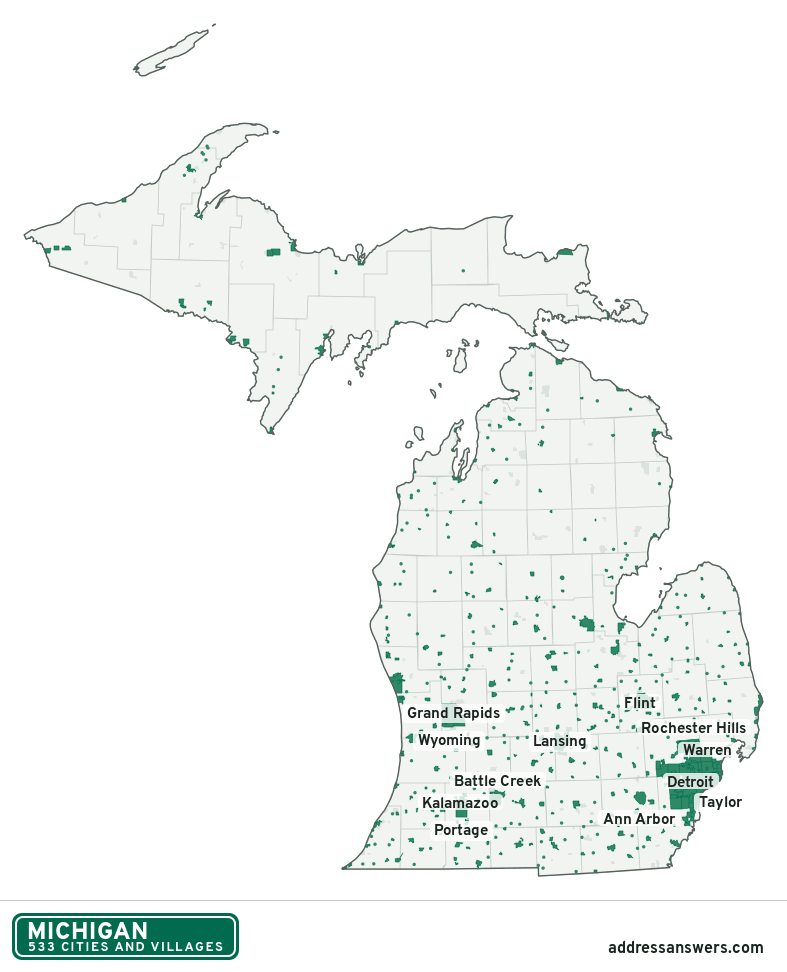
Michigan city limits map image
The map above as a picture: every Michigan city and town in green, with county lines. Boundaries from the Census Bureau, as of January 1, 2025.
You’re welcome to use it in a document or on your own site, with a link back to this page.
Download the map (PNG, 787 × 972)Questions about Michigan city limits
How many cities and villages are in Michigan?
Michigan has 533 incorporated places: 280 cities and 253 villages, by the Census Bureau’s boundary files for 2025.
What is the largest city in Michigan?
By population, Detroit, with about 638,530 residents (2020–2024 American Community Survey 5-year estimates). It is also the largest by land area, at 138.7 square miles.
What is the smallest village in Michigan?
By the Census Bureau’s estimate, Turner, with 86 residents. Estimates for places this small have a wide margin of error, so treat it as a rough count.
How much of Michigan is unincorporated?
96% of its land and 5 million of its residents (50%) are outside every city or village. There, local government is the township and the county. The state also has 212 named unincorporated communities; the largest is Forest Hills.
Is Forest Hills, MI a city?
No. Forest Hills is a census-designated place: a community the Census Bureau maps for statistics, with no city government of its own. About 28,695 people live there, in Kent County, in a township rather than a city. An address there is outside city limits, even if its mailing address says otherwise.
Is Allendale, MI a city?
No. Allendale is a census-designated place: a community the Census Bureau maps for statistics, with no city government of its own. About 26,679 people live there, in Ottawa County, in a township rather than a city. An address there is outside city limits, even if its mailing address says otherwise.
Which cities and villages in Michigan are in more than one county?
26 of the 533 cross a county line, by at least 1% of their land. The largest: Lansing (Ingham, Eaton, and Clinton), East Lansing (Ingham and Clinton), and Midland (Midland and Bay). Check an address to see which county it’s in.
Which county in Michigan has the most cities and villages?
Oakland County, with 40 at least partly inside it. Oscoda County has none.
Bordering states
More answers for a Michigan address
Each tool checks the same address and puts its own answer first.
- County Census Your county, plus the township or town where those exist. Find your county
- School district Census The public school district that covers the address. Find your school district
- Flood zone FEMA The FEMA zone in plain English, and whether lenders require flood insurance. Check flood zone
- USDA home loans USDA Whether the property is in an area eligible for a USDA Rural Development loan. Check USDA eligibility
- Voting districts Census Your congressional district and your state senate and state house districts. Included in every check
Places, boundaries, land area and counties: US Census Bureau 2025 cartographic boundary files (boundaries as of January 1, 2025). A place is listed in each county that holds at least 1% of its land. Population: 2020–2024 American Community Survey 5-year estimates. Data updated October 24, 2026; page updated October 25, 2026. Boundaries change through annexation; your city or county has the official map.