North Dakota city limits map
North Dakota has 355 incorporated cities. They cover 0.9% of the state’s land and are home to 78% of its residents. Everyone else lives outside city limits, where local government is the county. Enter an address to see which side of a city line it’s on.
Result for
The map couldn’t load. The answers don’t depend on it.
The boundary couldn’t load. The answer doesn’t depend on it.
Census Geocoder match
More about this address
Sources and limits
- Census
- US Census Bureau Geocoder, current boundaries
- FEMA
- National Flood Hazard Layer, effective flood maps
- USDA
- Rural Development property eligibility
- Map
- Boundaries from Census TIGERweb, flood zones drawn by FEMA, eligible areas from USDA, base map © OpenStreetMap contributors
Census boundaries are updated once a year, so a recent annexation may not show yet. Informational only, not an official determination. Verify with your city or county.
North Dakota at a glance
- Incorporated places
- 355
- 355 cities
- Residents in city limits
- 78%
- 615,066 of 784,841
- Land in city limits
- 0.9%
- 595.5 of 68,994 sq mi
- Counties
- 53
- Every one has at least one
- Unincorporated communities
- 51
- Largest: Minot AFB (4,878)
- Largest city
- Fargo
- 131,627 residents
How local government works in North Dakota
The Census Bureau maps 1,309 townships in North Dakota. Many have elected officers who look after rural roads; others exist only on maps. A township isn’t a city, so an address in one is outside city limits unless it’s also inside a city.
City limits map for Fargo
Its own page has the boundary in detail, the communities around it and its school districts.
All 355 cities in North Dakota
Every incorporated place, largest first, with the counties it’s in and its size. An address inside one of these is inside city limits; anywhere else in the state is unincorporated.
| Name | County | Population | Land (sq mi) |
|---|---|---|---|
| Fargo | Cass | 131,627 | 51.9 |
| Bismarck | Burleigh | 75,556 | 36.0 |
| Grand Forks | Grand Forks | 59,042 | 29.2 |
| Minot | Ward | 47,791 | 27.8 |
| West Fargo | Cass | 40,094 | 16.2 |
| Williston | Williams | 28,056 | 25.7 |
| Dickinson | Stark | 25,357 | 13.2 |
| Mandan | Morton | 24,522 | 13.5 |
| Jamestown | Stutsman | 15,787 | 13.4 |
| Wahpeton | Richland | 8,010 | 5.36 |
| Devils Lake | Ramsey | 7,308 | 6.96 |
| Valley City | Barnes | 6,541 | 4.30 |
| Watford City | McKenzie | 6,039 | 8.92 |
| Horace | Cass | 4,588 | 12.7 |
| Lincoln | Burleigh | 4,381 | 2.46 |
| Grafton | Walsh | 4,102 | 3.30 |
| Beulah | Mercer | 3,040 | 2.44 |
| Casselton | Cass | 2,953 | 2.16 |
| New Town | Mountrail | 2,721 | 2.89 |
| Rugby | Pierce | 2,481 | 2.31 |
| Hazen | Mercer | 2,453 | 1.41 |
| Lisbon | Ransom | 2,259 | 2.29 |
| Bottineau | Bottineau | 2,205 | 1.32 |
| Carrington | Foster | 2,168 | 2.37 |
| Stanley | Mountrail | 2,097 | 4.51 |
| Mayville | Traill | 1,976 | 1.88 |
| Oakes | Dickey | 1,858 | 1.56 |
| Langdon | Cavalier | 1,782 | 1.55 |
| Surrey | Ward | 1,721 | 2.11 |
| Hillsboro | Traill | 1,704 | 1.11 |
| Harvey | Wells | 1,679 | 1.80 |
| Tioga | Williams | 1,657 | 3.38 |
| Washburn | McLean | 1,507 | 1.68 |
| Bowman | Bowman | 1,499 | 1.86 |
| Park River | Walsh | 1,458 | 2.59 |
| Cavalier | Pembina | 1,426 | 0.86 |
| Garrison | McLean | 1,397 | 1.40 |
| Mapleton | Cass | 1,352 | 3.91 |
| New Rockford | Eddy | 1,260 | 1.72 |
| Hettinger | Adams | 1,250 | 0.83 |
| Larimore | Grand Forks | 1,240 | 0.60 |
| Cando | Towner | 1,164 | 0.68 |
| Thompson | Grand Forks | 1,138 | 0.43 |
| Velva | McHenry | 1,083 | 0.96 |
| Burlington | Ward | 1,067 | 1.91 |
| Crosby | Divide | 1,065 | 1.41 |
| Northwood | Grand Forks | 1,046 | 1.21 |
| Rolla | Rolette | 1,039 | 1.46 |
| Ellendale | Dickey | 1,033 | 1.42 |
| Reile's Acres | Cass | 1,032 | 1.13 |
| Kenmare | Ward | 1,002 | 1.34 |
| Kindred | Cass | 996 | 1.47 |
| Enderlin | Ransom | 985 | 1.63 |
| Killdeer | Dunn | 985 | 2.15 |
| Parshall | Mountrail | 922 | 3.55 |
| Cooperstown | Griggs | 918 | 1.01 |
| Linton | Emmons | 904 | 0.78 |
| Beach | Golden Valley | 899 | 2.55 |
| Walhalla | Pembina | 865 | 1.04 |
| Gwinner | Sargent | 859 | 2.06 |
| Wishek | McIntosh | 849 | 1.44 |
| Harwood | Cass | 819 | 1.30 |
| Dunseith | Rolette | 818 | 1.00 |
| Hankinson | Richland | 804 | 1.86 |
| Lakota | Nelson | 784 | 1.00 |
| New Salem | Morton | 780 | 1.38 |
| Richardton | Stark | 768 | 2.21 |
| Napoleon | Logan | 765 | 1.38 |
| Drayton | Pembina | 763 | 0.66 |
| Steele | Kidder | 757 | 0.56 |
| Mott | Hettinger | 742 | 0.92 |
| Lidgerwood | Richland | 719 | 0.64 |
| Minto | Walsh | 718 | 1.44 |
| Ray | Williams | 714 | 1.32 |
| Glen Ullin | Morton | 701 | 1.02 |
| Underwood | McLean | 699 | 1.01 |
| Belfield | Stark | 685 | 1.68 |
| Hebron | Morton | 677 | 1.50 |
| Edgeley | LaMoure | 666 | 0.75 |
| LaMoure | LaMoure | 658 | 1.34 |
| Milnor | Sargent | 648 | 1.00 |
| Mohall | Renville | 634 | 1.10 |
| Pembina | Pembina | 625 | 0.81 |
| Forman | Sargent | 617 | 0.78 |
| Hatton | Traill | 608 | 0.56 |
| Wilton | McLean, Burleigh | 607 | 0.56 |
| Ashley | McIntosh | 599 | 0.64 |
| Elgin | Grant | 585 | 0.82 |
| Argusville | Cass | 584 | 4.00 |
| New England | Hettinger | 564 | 0.49 |
| Center | Oliver | 562 | 0.48 |
| Portland | Traill | 549 | 0.83 |
| Strasburg | Emmons | 534 | 0.29 |
| Wyndmere | Richland | 509 | 0.86 |
| Leeds | Benson | 503 | 0.63 |
| South Heart | Stark | 503 | 1.35 |
| Turtle Lake | McLean | 500 | 0.51 |
| Oxbow | Cass | 491 | 1.53 |
| Kulm | LaMoure | 474 | 0.38 |
| Maddock | Benson | 474 | 0.88 |
| Stanton | Mercer | 470 | 0.36 |
| Towner | McHenry | 467 | 0.83 |
| Glenburn | Renville | 461 | 0.30 |
| Westhope | Bottineau | 435 | 0.32 |
| Fessenden | Wells | 433 | 0.44 |
| Berthold | Ward | 415 | 1.18 |
| Grenora | Williams | 408 | 0.61 |
| Neche | Pembina | 398 | 0.35 |
| Arthur | Cass | 392 | 1.53 |
| Halliday | Dunn | 389 | 0.46 |
| Scranton | Bowman | 387 | 0.69 |
| Manvel | Grand Forks | 368 | 0.29 |
| McVille | Nelson | 365 | 1.44 |
| Rolette | Rolette | 363 | 1.01 |
| Buxton | Traill | 360 | 0.33 |
| Max | McLean | 358 | 0.78 |
| Bowbells | Burke | 355 | 0.95 |
| Sawyer | Ward | 353 | 0.49 |
| Plaza | Mountrail | 350 | 1.08 |
| Reynolds | Traill, Grand Forks | 349 | 0.78 |
| Emerado | Grand Forks | 346 | 0.31 |
| Hope | Steele | 339 | 0.61 |
| Dunn Center | Dunn | 329 | 0.39 |
| Finley | Steele | 329 | 3.49 |
| McClusky | Sheridan | 327 | 0.37 |
| Gilby | Grand Forks | 322 | 0.18 |
| Carson | Grant | 316 | 3.99 |
| Anamoose | McHenry | 309 | 0.62 |
| St. Thomas | Pembina | 306 | 1.02 |
| Tower City | Cass, Barnes | 304 | 2.05 |
| Powers Lake | Burke | 301 | 1.39 |
| Drake | McHenry | 300 | 1.97 |
| Tappen | Kidder | 295 | 1.05 |
| Fairmount | Richland | 292 | 0.33 |
| Hunter | Cass | 292 | 1.49 |
| St. John | Rolette | 286 | 0.44 |
| Gackle | Logan | 284 | 0.54 |
| Granville | McHenry | 278 | 0.32 |
| Michigan City | Nelson | 277 | 0.50 |
| Colfax | Richland | 272 | 1.01 |
| Walcott | Richland | 272 | 1.02 |
| Wildrose | Williams | 260 | 0.29 |
| Golden Valley | Mercer | 258 | 0.75 |
| Munich | Cavalier | 257 | 1.43 |
| Alexander | McKenzie | 255 | 1.24 |
| Christine | Richland | 255 | 0.20 |
| Medina | Stutsman | 255 | 1.21 |
| Leonard | Cass | 248 | 0.75 |
| Davenport | Cass | 245 | 0.27 |
| Sherwood | Renville | 244 | 0.32 |
| Edmore | Ramsey | 240 | 0.29 |
| Willow City | Bottineau | 238 | 0.47 |
| Kensal | Stutsman | 233 | 0.60 |
| Abercrombie | Richland | 232 | 0.33 |
| Oriska | Barnes | 231 | 0.27 |
| Gladstone | Stark | 230 | 0.36 |
| Hoople | Walsh | 228 | 0.54 |
| Benedict | McLean | 227 | 0.25 |
| Flasher | Morton | 222 | 0.64 |
| Lansford | Bottineau | 216 | 0.35 |
| Fordville | Walsh | 212 | 1.01 |
| Wing | Burleigh | 207 | 0.64 |
| Hazelton | Emmons | 206 | 0.38 |
| Arnegard | McKenzie | 201 | 0.34 |
| Zap | Mercer | 200 | 1.02 |
| Medora | Billings | 198 | 0.39 |
| Selfridge | Sioux | 198 | 0.29 |
| Sheyenne | Eddy | 198 | 0.15 |
| Edinburg | Walsh | 196 | 0.32 |
| Minnewaukan | Benson | 191 | 0.48 |
| Riverdale | McLean | 187 | 1.39 |
| Litchville | Barnes | 185 | 2.26 |
| Carpio | Ward | 184 | 0.63 |
| Rhame | Bowman | 184 | 1.50 |
| Almont | Morton | 183 | 2.49 |
| New Leipzig | Grant | 181 | 0.89 |
| Regent | Hettinger | 181 | 0.56 |
| Buffalo | Cass | 180 | 0.48 |
| Taylor | Stark | 179 | 0.50 |
| Spiritwood Lake | Stutsman | 177 | 1.14 |
| Marion | LaMoure | 176 | 0.84 |
| Mooreton | Richland | 175 | 0.27 |
| Fingal | Barnes | 174 | 0.42 |
| Frontier | Cass | 169 | 0.19 |
| Binford | Griggs | 168 | 0.35 |
| Lignite | Burke | 167 | 0.16 |
| Page | Cass | 165 | 1.00 |
| Des Lacs | Ward | 163 | 0.54 |
| Noonan | Divide | 163 | 0.29 |
| Wimbledon | Barnes | 159 | 0.62 |
| Aneta | Nelson | 157 | 1.00 |
| Ross | Mountrail | 156 | 0.29 |
| Pick City | Mercer | 144 | 0.19 |
| Amenia | Cass | 135 | 1.49 |
| Buchanan | Stutsman | 130 | 0.08 |
| Palermo | Mountrail | 129 | 2.25 |
| Portal | Burke | 129 | 0.67 |
| Gardner | Cass | 125 | 0.50 |
| Reeder | Adams | 125 | 0.69 |
| Epping | Williams | 124 | 0.37 |
| Tolna | Nelson | 124 | 0.75 |
| Adams | Walsh | 121 | 0.98 |
| Petersburg | Nelson | 120 | 1.03 |
| Grandin | Cass, Traill | 119 | 0.18 |
| Verona | LaMoure | 116 | 0.58 |
| Osnabrock | Cavalier | 115 | 0.30 |
| Crary | Ramsey | 114 | 0.95 |
| Sykeston | Wells | 114 | 0.40 |
| Cogswell | Sargent | 110 | 0.33 |
| Dodge | Dunn | 109 | 0.47 |
| Lankin | Walsh | 109 | 0.29 |
| Cleveland | Stutsman | 107 | 0.21 |
| Fort Yates | Sioux | 107 | 0.06 |
| Fort Ransom | Ransom | 106 | 0.31 |
| Solen | Sioux | 105 | 0.33 |
| Crystal | Pembina | 103 | 0.69 |
| Rutland | Sargent | 103 | 0.39 |
| Sanborn | Barnes | 103 | 0.60 |
| Rocklake | Towner | 102 | 0.21 |
| Upham | McHenry | 102 | 0.31 |
| Sharon | Steele | 101 | 1.49 |
| Marmarth | Slope | 100 | 2.58 |
| Mountain | Pembina | 100 | 0.12 |
| Ryder | Ward | 100 | 0.52 |
| Montpelier | Stutsman | 99 | 0.15 |
| Streeter | Stutsman | 98 | 0.36 |
| Golva | Golden Valley | 97 | 0.32 |
| Zeeland | McIntosh | 96 | 0.30 |
| Douglas | Ward | 94 | 0.28 |
| Pisek | Walsh | 91 | 0.11 |
| Bowdon | Wells | 90 | 0.25 |
| Sheldon | Ransom | 89 | 0.41 |
| Forest River | Walsh | 87 | 0.50 |
| Havana | Sargent | 86 | 0.38 |
| Bisbee | Towner | 85 | 0.30 |
| Goodrich | Sheridan | 85 | 0.29 |
| Regan | Burleigh | 85 | 1.01 |
| Makoti | Ward | 84 | 0.54 |
| Warwick | Benson | 83 | 0.65 |
| Egeland | Towner | 81 | 0.32 |
| Martin | Sheridan | 80 | 0.09 |
| Esmond | Benson | 78 | 0.45 |
| Hague | Emmons | 78 | 0.26 |
| Hannaford | Griggs | 77 | 0.22 |
| Kathryn | Barnes | 77 | 0.58 |
| Venturia | McIntosh | 75 | 0.11 |
| Donnybrook | Ward | 74 | 0.68 |
| Dawson | Kidder | 72 | 0.34 |
| North River | Cass | 70 | 0.06 |
| Tuttle | Kidder | 70 | 0.25 |
| Woodworth | Stutsman | 69 | 0.21 |
| Butte | McLean | 68 | 0.25 |
| Deering | McHenry | 68 | 0.08 |
| Columbus | Burke | 67 | 0.27 |
| Newburg | Bottineau | 67 | 0.14 |
| Coleharbor | McLean | 66 | 0.18 |
| Dickey | LaMoure | 66 | 0.24 |
| Lehr | McIntosh, Logan | 66 | 0.19 |
| McHenry | Foster | 66 | 0.25 |
| Mercer | McLean | 66 | 0.22 |
| Fullerton | Dickey | 65 | 0.39 |
| Pettibone | Kidder | 65 | 0.18 |
| Glenfield | Foster | 63 | 0.14 |
| White Earth | Mountrail | 63 | 1.50 |
| Dazey | Barnes | 62 | 0.38 |
| Karlsruhe | McHenry | 62 | 0.75 |
| Pekin | Nelson | 62 | 0.25 |
| Grace City | Foster | 61 | 0.24 |
| Pingree | Stutsman | 61 | 0.19 |
| Briarwood | Cass | 60 | 0.14 |
| Sentinel Butte | Golden Valley | 57 | 1.03 |
| Bathgate | Pembina | 56 | 0.28 |
| Maxbass | Bottineau | 56 | 0.16 |
| Clifford | Traill | 54 | 0.14 |
| Balta | Pierce | 52 | 0.23 |
| Landa | Bottineau | 52 | 0.08 |
| Luverne | Steele | 52 | 0.26 |
| Berlin | LaMoure | 50 | 0.10 |
| Robinson | Kidder | 50 | 0.17 |
| Starkweather | Ramsey | 50 | 0.13 |
| Nome | Barnes | 49 | 0.41 |
| Alamo | Williams | 47 | 0.55 |
| Dwight | Richland | 47 | 0.19 |
| Fredonia | Logan | 46 | 0.24 |
| Galesburg | Traill | 44 | 0.17 |
| Brocket | Ramsey | 43 | 0.76 |
| Milton | Cavalier | 43 | 0.47 |
| Prairie Rose | Cass | 43 | 0.04 |
| Voltaire | McHenry | 43 | 0.49 |
| Barney | Richland | 42 | 0.18 |
| Jud | LaMoure | 42 | 0.24 |
| Fortuna | Divide | 41 | 1.01 |
| Alsen | Cavalier | 39 | 29.4 |
| Hamilton | Pembina | 39 | 0.28 |
| Oberon | Benson | 39 | 0.35 |
| Souris | Bottineau | 38 | 0.10 |
| Gardena | Bottineau | 37 | 0.34 |
| Great Bend | Richland | 37 | 0.56 |
| Mantador | Richland | 37 | 0.14 |
| Hurdsfield | Wells | 35 | 0.29 |
| Tolley | Renville | 35 | 0.13 |
| Ambrose | Divide | 33 | 1.01 |
| Elliott | Ransom | 33 | 0.15 |
| Cayuga | Sargent | 30 | 1.00 |
| Forbes | Dickey | 30 | 0.24 |
| Leith | Grant | 30 | 1.24 |
| Courtenay | Stutsman | 29 | 0.42 |
| Canton City (Hensel) | Pembina | 28 | 0.25 |
| Gascoyne | Bowman | 28 | 1.00 |
| Inkster | Grand Forks | 27 | 0.99 |
| Springbrook | Williams | 27 | 0.37 |
| Rogers | Barnes | 26 | 0.98 |
| Wolford | Pierce | 26 | 0.18 |
| Niagara | Grand Forks | 24 | 0.94 |
| Haynes | Adams | 23 | 0.14 |
| Leal | Barnes | 23 | 0.13 |
| Ardoch | Walsh | 22 | 0.38 |
| Bucyrus | Adams | 22 | 0.35 |
| Ludden | Dickey | 22 | 0.80 |
| Nekoma | Cavalier | 22 | 0.37 |
| Brinsmade | Benson | 21 | 0.27 |
| Hampden | Ramsey | 21 | 0.17 |
| Kramer | Bottineau | 21 | 0.15 |
| Lawton | Ramsey | 21 | 0.91 |
| Sibley | Barnes | 20 | 0.04 |
| Sarles | Cavalier, Towner | 19 | 0.26 |
| Alice | Cass | 18 | 0.97 |
| Knox | Benson | 18 | 0.48 |
| Loraine | Renville | 18 | 0.25 |
| Monango | Dickey | 18 | 0.38 |
| Cathay | Wells | 17 | 0.18 |
| Fairdale | Walsh | 16 | 0.32 |
| Flaxton | Burke | 16 | 0.28 |
| Antler | Bottineau | 15 | 0.19 |
| Ayr | Cass | 14 | 0.08 |
| Calio | Cavalier | 14 | 8.17 |
| Braddock | Emmons | 13 | 0.25 |
| Conway | Walsh | 11 | 0.21 |
| Overly | Bottineau | 10 | 0.37 |
| Pillsbury | Barnes | 10 | 0.26 |
| Mylo | Rolette | 8 | 0.86 |
| Amidon | Slope | 6 | 0.63 |
| Loma | Cavalier | 6 | 26.5 |
| Perth | Towner | 6 | 0.13 |
| York | Benson | 6 | 0.21 |
| Calvin | Cavalier | 5 | 0.22 |
| Hansboro | Towner | 5 | 0.19 |
| Hannah | Cavalier | 4 | 0.19 |
| Ruso | McLean | 4 | 0.25 |
| Balfour | McHenry | 3 | 0.56 |
| Grano | Renville | 3 | 0.29 |
| Hamberg | Wells | 3 | 0.41 |
| Wales | Cavalier | 2 | 0.24 |
| Bergen | McHenry | 1 | 0.75 |
| Kief | McHenry | 0 | 1.23 |
Showing 1–50 of 355
Unincorporated communities in North Dakota
Census-designated places: named communities the Census Bureau maps for statistics, with no city government of their own. An address in one is outside city limits, even when its mailing address names a city. North Dakota has 51.
| Community | County | Population | Land (sq mi) |
|---|---|---|---|
| Minot AFB | Ward | 4,878 | 7.27 |
| Grand Forks AFB | Grand Forks | 1,987 | 7.50 |
| Belcourt | Rolette | 1,547 | 5.81 |
| Shell Valley | Rolette | 1,243 | 15.0 |
| Fort Totten | Benson | 1,038 | 8.60 |
| Green Acres | Rolette | 994 | 1.50 |
| Cannon Ball | Sioux | 748 | 88.3 |
| Mandaree | McKenzie | 620 | 11.1 |
| East Dunseith | Rolette | 450 | 5.13 |
| Trenton | Williams | 406 | 1.05 |
| Apple Valley | Burleigh | 279 | 0.15 |
| White Shield | McLean | 246 | 3.80 |
| Harmon | Morton | 198 | 1.57 |
| Four Bears Village | McKenzie | 154 | 1.02 |
| Porcupine | Sioux | 138 | 0.20 |
| East Fairview | McKenzie | 137 | 0.38 |
| McLeod | Ransom | 129 | 0.77 |
| McGregor | Williams | 108 | 0.13 |
| Ruthville | Ward | 104 | 0.15 |
| Menoken | Burleigh | 102 | 2.18 |
| Blacktail | Williams | 93 | 0.33 |
| Caledonia | Traill | 74 | 0.52 |
| Logan | Ward | 70 | 1.46 |
| Wheatland | Cass | 70 | 4.01 |
| Driscoll | Burleigh | 59 | 0.58 |
| Erie | Cass | 58 | 2.01 |
| Ypsilanti | Stutsman | 55 | 0.55 |
| Spiritwood | Stutsman | 46 | 0.88 |
| Manning | Dunn | 43 | 0.57 |
| Embden | Cass | 41 | 0.72 |
| Heimdal | Wells | 40 | 0.47 |
| Long Creek | Williams | 38 | 0.24 |
| Foxholm | Ward | 34 | 0.96 |
| Selz | Pierce | 30 | 0.14 |
| Auburn | Walsh | 28 | 1.01 |
| Brooktree Park | Cass | 23 | 0.18 |
| Dahlen | Nelson | 20 | 0.14 |
| Raleigh | Grant | 20 | 0.29 |
| Sutton | Griggs | 16 | 0.20 |
| Denhoff | Sheridan | 11 | 0.66 |
| Englevale | Ransom | 11 | 1.49 |
| De Lamere | Sargent | 10 | 0.26 |
| Larson | Burke | 10 | 0.41 |
| Heil | Grant | 8 | 0.20 |
| Jessie | Griggs | 8 | 0.47 |
| Nash | Walsh | 7 | 1.02 |
| Bantry | McHenry | 5 | 0.93 |
| Churchs Ferry | Ramsey | 4 | 0.43 |
| Barton | Pierce | 0 | 0.34 |
| Blanchard | Traill | 0 | 0.25 |
| Orrin | Pierce | 0 | 0.23 |
Showing 1–50 of 51
Counties in North Dakota
53 counties, with how many cities have land in each and the largest whose main county it is.
| County | Cities | Largest | Population | Land (sq mi) |
|---|---|---|---|---|
| Cass County | 26 | Fargo | 193,400 | 1,765 |
| Burleigh County | 5 | Bismarck | 100,600 | 1,633 |
| Grand Forks County | 10 | Grand Forks | 72,923 | 1,436 |
| Ward County | 12 | Minot | 68,973 | 2,013 |
| Williams County | 8 | Williston | 39,555 | 2,078 |
| Morton County | 6 | Mandan | 33,777 | 1,926 |
| Stark County | 6 | Dickinson | 33,302 | 1,335 |
| Stutsman County | 11 | Jamestown | 21,549 | 2,222 |
| Richland County | 14 | Wahpeton | 16,584 | 1,436 |
| McKenzie County | 3 | Watford City | 14,321 | 2,760 |
| Rolette County | 5 | Rolla | 11,924 | 903.0 |
| Ramsey County | 7 | Devils Lake | 11,556 | 1,185 |
| Barnes County | 14 | Valley City | 10,773 | 1,492 |
| Walsh County | 13 | Grafton | 10,396 | 1,282 |
| McLean County | 12 | Washburn | 9,823 | 2,110 |
| Mountrail County | 7 | New Town | 9,507 | 1,825 |
| Mercer County | 6 | Beulah | 8,337 | 1,043 |
| Traill County | 9 | Mayville | 7,970 | 861.9 |
| Pembina County | 11 | Cavalier | 6,727 | 1,119 |
| Bottineau County | 12 | Bottineau | 6,378 | 1,669 |
| Benson County | 9 | Leeds | 5,808 | 1,389 |
| Ransom County | 5 | Lisbon | 5,643 | 862.5 |
| McHenry County | 12 | Velva | 5,207 | 1,874 |
| Dickey County | 6 | Oakes | 4,935 | 1,132 |
| LaMoure County | 8 | Edgeley | 4,118 | 1,146 |
| Dunn County | 4 | Killdeer | 4,040 | 2,009 |
| Pierce County | 3 | Rugby | 3,928 | 1,018 |
| Wells County | 7 | Harvey | 3,890 | 1,271 |
| Sargent County | 7 | Gwinner | 3,804 | 858.5 |
| Sioux County | 3 | Selfridge | 3,740 | 1,094 |
| Cavalier County | 12 | Langdon | 3,633 | 1,489 |
| Foster County | 4 | Carrington | 3,358 | 634.1 |
| Emmons County | 5 | Linton | 3,254 | 1,508 |
| Nelson County | 7 | Lakota | 3,016 | 981.8 |
| Bowman County | 4 | Bowman | 2,906 | 1,162 |
| McIntosh County | 5 | Wishek | 2,497 | 974.6 |
| Hettinger County | 3 | Mott | 2,432 | 1,132 |
| Kidder County | 6 | Steele | 2,377 | 1,351 |
| Eddy County | 2 | New Rockford | 2,307 | 630.2 |
| Renville County | 6 | Mohall | 2,304 | 877.2 |
| Grant County | 4 | Elgin | 2,269 | 1,659 |
| Griggs County | 3 | Cooperstown | 2,245 | 708.7 |
| Divide County | 4 | Crosby | 2,167 | 1,261 |
| Burke County | 6 | Bowbells | 2,156 | 1,104 |
| Adams County | 4 | Hettinger | 2,145 | 987.5 |
| Towner County | 7 | Cando | 2,079 | 1,025 |
| Oliver County | 1 | Center | 1,839 | 722.4 |
| Logan County | 4 | Napoleon | 1,819 | 992.6 |
| Steele County | 4 | Hope | 1,804 | 712.1 |
| Golden Valley County | 3 | Beach | 1,653 | 1,001 |
| Sheridan County | 3 | McClusky | 1,303 | 972.2 |
| Billings County | 1 | Medora | 1,024 | 1,149 |
| Slope County | 2 | Marmarth | 766 | 1,215 |
Showing 1–50 of 53
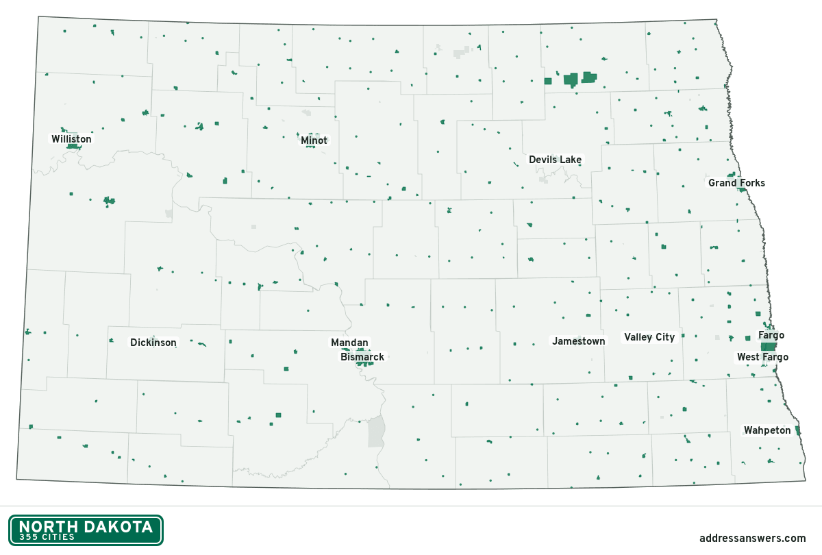
North Dakota city limits map image
The map above as a picture: every North Dakota city and town in green, with county lines. Boundaries from the Census Bureau, as of January 1, 2025.
You’re welcome to use it in a document or on your own site, with a link back to this page.
Download the map (PNG, 1,200 × 810)Questions about North Dakota city limits
How many cities are in North Dakota?
North Dakota has 355 incorporated places: 355 cities, by the Census Bureau’s boundary files for 2025.
What is the largest city in North Dakota?
By population, Fargo, with about 131,627 residents (2020–2024 American Community Survey 5-year estimates). It is also the largest by land area, at 51.9 square miles.
What is the smallest city in North Dakota?
By the Census Bureau’s estimate, Bergen, with 1 resident. Estimates for places this small have a wide margin of error, so treat it as a rough count.
How much of North Dakota is unincorporated?
99.1% of its land and 169,775 of its residents (22%) are outside every city. There, local government is the county. The state also has 51 named unincorporated communities; the largest is Minot AFB.
Is Minot AFB, ND a city?
No. Minot AFB is a census-designated place: a community the Census Bureau maps for statistics, with no city government of its own. About 4,878 people live there, in unincorporated Ward County. An address there is outside city limits, even if its mailing address says otherwise.
Is Grand Forks AFB, ND a city?
No. Grand Forks AFB is a census-designated place: a community the Census Bureau maps for statistics, with no city government of its own. About 1,987 people live there, in unincorporated Grand Forks County. An address there is outside city limits, even if its mailing address says otherwise.
Which cities in North Dakota are in more than one county?
Six of the 355 cross a county line, by at least 1% of their land. The largest: Wilton (McLean and Burleigh), Reynolds (Traill and Grand Forks), and Tower City (Cass and Barnes). Check an address to see which county it’s in.
Which county in North Dakota has the most cities?
Cass County, with 26 at least partly inside it. Every county in North Dakota has at least one.
Bordering states
More answers for a North Dakota address
Each tool checks the same address and puts its own answer first.
- County Census Your county, plus the township or town where those exist. Find your county
- School district Census The public school district that covers the address. Find your school district
- Flood zone FEMA The FEMA zone in plain English, and whether lenders require flood insurance. Check flood zone
- USDA home loans USDA Whether the property is in an area eligible for a USDA Rural Development loan. Check USDA eligibility
- Voting districts Census Your congressional district and your state senate and state house districts. Included in every check
Places, boundaries, land area and counties: US Census Bureau 2025 cartographic boundary files (boundaries as of January 1, 2025). A place is listed in each county that holds at least 1% of its land. Population: 2020–2024 American Community Survey 5-year estimates. Data updated October 24, 2026; page updated October 25, 2026. Boundaries change through annexation; your city or county has the official map.