Montana city limits map
Montana has 127 incorporated places: 54 cities and 73 towns. They cover 1.2% of the state’s land and are home to 54% of its residents. Everyone else lives outside city limits, where local government is the county. Enter an address to see which side of a city line it’s on.
Result for
The map couldn’t load. The answers don’t depend on it.
The boundary couldn’t load. The answer doesn’t depend on it.
Census Geocoder match
More about this address
Sources and limits
- Census
- US Census Bureau Geocoder, current boundaries
- FEMA
- National Flood Hazard Layer, effective flood maps
- USDA
- Rural Development property eligibility
- Map
- Boundaries from Census TIGERweb, flood zones drawn by FEMA, eligible areas from USDA, base map © OpenStreetMap contributors
Census boundaries are updated once a year, so a recent annexation may not show yet. Informational only, not an official determination. Verify with your city or county.
Montana at a glance
- Incorporated places
- 127
- 54 cities and 73 towns
- Residents in city limits
- 54%
- 608,167 of 1,116,875
- Land in city limits
- 1.2%
- 1,764 of 145,550 sq mi
- Counties
- 56
- Every one has at least one
- Unincorporated communities
- 370
- Largest: Evergreen (9,611)
- Largest city
- Billings
- 119,434 residents
City limits map for Billings
Its own page has the boundary in detail, the communities around it and its school districts.
All 127 cities and towns in Montana
Every incorporated place, largest first, with the counties it’s in and its size. An address inside one of these is inside city limits; anywhere else in the state is unincorporated.
| Name | Type | County | Population | Land (sq mi) |
|---|---|---|---|---|
| Billings | City | Yellowstone | 119,434 | 46.3 |
| Missoula | City | Missoula | 76,514 | 35.0 |
| Great Falls | City | Cascade | 60,329 | 23.2 |
| Bozeman | City | Gallatin | 56,114 | 21.4 |
| Butte-Silver Bow | City | Silver Bow | 35,052 | 715.8 |
| Helena | City | Lewis and Clark | 33,639 | 17.3 |
| Kalispell | City | Flathead | 28,504 | 13.1 |
| Belgrade | City | Gallatin | 11,872 | 5.98 |
| Anaconda-Deer Lodge County | City | Deer Lodge | 9,597 | 736.7 |
| Havre | City | Hill | 9,258 | 3.71 |
| Livingston | City | Park | 8,780 | 6.07 |
| Whitefish | City | Flathead | 8,749 | 7.39 |
| Miles City | City | Custer | 8,407 | 3.36 |
| Laurel | City | Yellowstone | 7,215 | 2.60 |
| Sidney | City | Richland | 6,171 | 3.29 |
| Lewistown | City | Fergus | 6,087 | 5.72 |
| Columbia Falls | City | Flathead | 5,615 | 2.28 |
| Polson | City | Lake | 5,428 | 4.67 |
| Hamilton | City | Ravalli | 5,101 | 2.57 |
| Glendive | City | Dawson | 4,810 | 3.47 |
| Dillon | City | Beaverhead | 4,085 | 1.93 |
| Hardin | City | Big Horn | 3,742 | 2.99 |
| Shelby | City | Toole | 3,216 | 5.78 |
| Glasgow | City | Valley | 3,190 | 1.40 |
| Libby | City | Lincoln | 3,042 | 1.84 |
| Cut Bank | City | Glacier | 3,028 | 1.16 |
| Deer Lodge | City | Powell | 3,021 | 1.56 |
| Conrad | City | Pondera | 2,618 | 1.27 |
| Wolf Point | City | Roosevelt | 2,602 | 0.88 |
| Red Lodge | City | Carbon | 2,502 | 2.71 |
| Manhattan | Town | Gallatin | 2,288 | 1.75 |
| Stevensville | Town | Ravalli | 2,130 | 1.30 |
| Colstrip | City | Rosebud | 2,101 | 4.05 |
| Malta | City | Phillips | 2,100 | 1.07 |
| Columbus | Town | Stillwater | 2,003 | 1.37 |
| Roundup | City | Musselshell | 2,003 | 1.29 |
| Ronan | City | Lake | 2,001 | 1.55 |
| Townsend | City | Broadwater | 1,967 | 1.53 |
| Three Forks | City | Gallatin | 1,919 | 1.44 |
| Eureka | Town | Lincoln | 1,840 | 1.33 |
| Forsyth | City | Rosebud | 1,728 | 1.15 |
| East Helena | City | Lewis and Clark | 1,702 | 4.05 |
| Plentywood | City | Sheridan | 1,654 | 1.36 |
| Big Timber | City | Sweet Grass | 1,611 | 0.98 |
| Thompson Falls | City | Sanders | 1,500 | 1.60 |
| Baker | City | Fallon | 1,489 | 1.03 |
| Choteau | City | Teton | 1,479 | 1.46 |
| Fort Benton | City | Chouteau | 1,474 | 2.30 |
| West Yellowstone | Town | Gallatin | 1,474 | 0.91 |
| Chinook | City | Blaine | 1,353 | 0.52 |
| Boulder | City | Jefferson | 1,284 | 1.12 |
| Plains | Town | Sanders | 1,195 | 0.61 |
| Whitehall | Town | Jefferson | 1,156 | 0.71 |
| Harlowton | City | Wheatland | 1,058 | 0.63 |
| St. Ignatius | Town | Lake | 977 | 0.53 |
| Fairview | Town | Richland | 971 | 0.80 |
| White Sulphur Springs | City | Meagher | 957 | 0.99 |
| Superior | Town | Mineral | 896 | 0.95 |
| Troy | City | Lincoln | 871 | 0.85 |
| Sheridan | Town | Madison | 869 | 1.01 |
| Scobey | City | Daniels | 861 | 0.74 |
| Pinesdale | Town | Ravalli | 833 | 1.30 |
| Harlem | City | Blaine | 822 | 0.42 |
| Bridger | Town | Carbon | 788 | 0.84 |
| Big Sandy | Town | Chouteau | 784 | 0.48 |
| Ennis | Town | Madison | 777 | 0.74 |
| Fairfield | Town | Teton | 759 | 0.31 |
| Philipsburg | Town | Granite | 754 | 0.85 |
| Chester | Town | Liberty | 749 | 0.49 |
| Walkerville | Town | Silver Bow | 733 | 2.23 |
| Wibaux | Town | Wibaux | 672 | 1.07 |
| Poplar | City | Roosevelt | 635 | 0.28 |
| Joliet | Town | Carbon | 613 | 0.27 |
| Alberton | Town | Mineral | 573 | 0.55 |
| Valier | Town | Pondera | 573 | 0.87 |
| Cascade | Town | Cascade | 572 | 0.66 |
| Culbertson | Town | Roosevelt | 567 | 1.15 |
| Belt | Town | Cascade | 559 | 0.34 |
| Hot Springs | Town | Sanders | 557 | 0.48 |
| Terry | Town | Prairie | 537 | 0.78 |
| Darby | Town | Ravalli | 527 | 0.67 |
| Circle | Town | McCone | 514 | 0.78 |
| Broadus | Town | Powder River | 459 | 0.35 |
| Fromberg | Town | Carbon | 438 | 0.44 |
| Lodge Grass | Town | Big Horn | 429 | 0.26 |
| Clyde Park | Town | Park | 341 | 0.37 |
| Bainville | Town | Roosevelt | 334 | 1.26 |
| Froid | Town | Roosevelt | 324 | 0.62 |
| Jordan | Town | Garfield | 321 | 0.35 |
| Geraldine | Town | Chouteau | 317 | 0.57 |
| Sunburst | Town | Toole | 301 | 1.92 |
| Westby | Town | Sheridan | 290 | 0.56 |
| Fort Peck | Town | Valley | 280 | 0.89 |
| Nashua | Town | Valley | 279 | 0.71 |
| Drummond | Town | Granite | 277 | 0.54 |
| Ekalaka | Town | Carter | 276 | 1.03 |
| Ryegate | Town | Golden Valley | 273 | 0.75 |
| Dutton | Town | Teton | 268 | 0.32 |
| Stanford | Town | Judith Basin | 268 | 0.43 |
| Winifred | Town | Fergus | 263 | 0.52 |
| Hysham | Town | Treasure | 251 | 0.22 |
| Richey | Town | Dawson | 238 | 0.26 |
| Moore | Town | Fergus | 224 | 0.29 |
| Lima | Town | Beaverhead | 218 | 0.56 |
| Medicine Lake | Town | Sheridan | 213 | 0.40 |
| Plevna | Town | Fallon | 209 | 0.59 |
| Winnett | Town | Petroleum | 204 | 1.02 |
| Twin Bridges | Town | Madison | 201 | 1.01 |
| Denton | Town | Fergus | 193 | 0.71 |
| Broadview | Town | Yellowstone | 175 | 0.26 |
| Hobson | City | Judith Basin | 160 | 0.21 |
| Dodson | Town | Phillips | 153 | 0.17 |
| Judith Gap | City | Wheatland | 140 | 0.34 |
| Saco | Town | Phillips | 140 | 0.30 |
| Lavina | Town | Golden Valley | 134 | 1.01 |
| Rexford | Town | Lincoln | 134 | 0.08 |
| Virginia City | Town | Madison | 129 | 0.95 |
| Hingham | Town | Hill | 127 | 0.17 |
| Grass Range | Town | Fergus | 125 | 0.14 |
| Kevin | Town | Toole | 108 | 0.36 |
| Bearcreek | Town | Carbon | 88 | 0.11 |
| Opheim | Town | Valley | 86 | 0.21 |
| Melstone | Town | Musselshell | 80 | 0.61 |
| Flaxville | Town | Daniels | 77 | 0.08 |
| Outlook | Town | Sheridan | 51 | 1.25 |
| Neihart | Town | Cascade | 39 | 1.99 |
| Ismay | Town | Custer | 1 | 0.42 |
Showing 1–50 of 127
Unincorporated communities in Montana
Census-designated places: named communities the Census Bureau maps for statistics, with no city government of their own. An address in one is outside city limits, even when its mailing address names a city. Montana has 370.
| Community | County | Population | Land (sq mi) |
|---|---|---|---|
| Evergreen | Flathead | 9,611 | 8.55 |
| Helena Valley Southeast | Lewis and Clark | 9,108 | 21.5 |
| Helena Valley West Central | Lewis and Clark | 8,056 | 26.4 |
| Lockwood | Yellowstone | 7,181 | 12.9 |
| Four Corners | Gallatin | 5,791 | 10.8 |
| Orchard Homes | Missoula | 5,588 | 5.61 |
| Bigfork | Flathead | 5,565 | 31.3 |
| Helena Valley Northwest | Lewis and Clark | 5,183 | 16.4 |
| Helena Valley Northeast | Lewis and Clark | 4,659 | 53.2 |
| Lolo | Missoula | 4,314 | 9.46 |
| Malmstrom AFB | Cascade | 4,302 | 5.11 |
| North Browning | Glacier | 3,144 | 2.89 |
| Montana City | Jefferson | 3,092 | 34.1 |
| Big Sky | Gallatin | 2,445 | 120.0 |
| Lakeside | Flathead | 2,386 | 14.1 |
| Crow Agency | Big Horn | 2,192 | 7.34 |
| West Glendive | Dawson | 2,121 | 3.84 |
| East Missoula | Missoula | 2,099 | 1.15 |
| King Arthur Park | Gallatin | 1,992 | 0.46 |
| Frenchtown | Missoula | 1,927 | 6.74 |
| Clancy | Jefferson | 1,874 | 39.2 |
| Lame Deer | Rosebud | 1,872 | 55.6 |
| Wheatland | Broadwater | 1,661 | 74.5 |
| Pablo | Lake | 1,632 | 4.85 |
| Bonner-West Riverside | Missoula | 1,563 | 1.53 |
| South Browning | Glacier | 1,538 | 2.34 |
| Seeley Lake | Missoula | 1,496 | 12.3 |
| Helena West Side | Lewis and Clark | 1,417 | 15.0 |
| Somers | Flathead | 1,280 | 2.95 |
| Corvallis | Ravalli | 1,227 | 0.58 |
| Fort Belknap Agency | Blaine | 1,227 | 45.5 |
| Sun Prairie | Cascade | 1,171 | 5.30 |
| Churchill | Gallatin | 1,167 | 3.55 |
| Pray | Park | 1,129 | 28.6 |
| Wye | Missoula | 1,055 | 2.91 |
| Clinton | Missoula | 1,040 | 3.27 |
| Marion | Flathead | 1,037 | 16.9 |
| Hays | Blaine | 1,009 | 27.1 |
| Rocky Boy West | Chouteau | 1,007 | 5.45 |
| Vaughn | Cascade | 1,002 | 3.57 |
| White Haven | Lincoln | 978 | 0.99 |
| Ashland | Rosebud | 959 | 20.7 |
| Ponderosa Pines | Gallatin | 950 | 39.6 |
| Browning | Glacier | 943 | 0.28 |
| Gallatin Gateway | Gallatin | 933 | 5.85 |
| Absarokee | Stillwater | 926 | 2.14 |
| Florence | Ravalli | 923 | 0.77 |
| Lincoln | Lewis and Clark | 908 | 17.5 |
| Ulm | Cascade | 900 | 20.3 |
| Havre North | Hill | 890 | 3.35 |
| Victor | Ravalli | 867 | 0.45 |
| Helena Flats | Flathead | 857 | 8.43 |
| Woods Bay | Lake | 835 | 1.36 |
| Arlee | Lake | 812 | 6.47 |
| Pioneer Junction | Lincoln | 798 | 3.52 |
| Black Eagle | Cascade | 781 | 1.54 |
| Park City | Stillwater | 764 | 1.57 |
| Spokane Creek | Broadwater | 740 | 17.3 |
| Muddy | Big Horn | 724 | 28.6 |
| Trego | Lincoln | 692 | 53.9 |
| Batavia | Flathead | 690 | 1.81 |
| Carlton | Missoula | 682 | 6.16 |
| Hungry Horse | Flathead | 679 | 1.43 |
| Gardiner | Park | 647 | 5.79 |
| South Hills | Jefferson | 620 | 5.87 |
| Riverbend | Mineral | 592 | 3.94 |
| The Silos | Broadwater | 579 | 5.13 |
| Busby | Big Horn | 569 | 14.3 |
| Turah | Missoula | 543 | 1.33 |
| Jefferson City | Jefferson | 533 | 23.2 |
| Lindisfarne | Lake | 533 | 2.58 |
| Heart Butte | Pondera | 521 | 4.56 |
| Pryor | Big Horn | 497 | 39.8 |
| West Kootenai | Lincoln | 494 | 16.1 |
| Lewistown Heights | Fergus | 488 | 2.36 |
| Wyola | Big Horn | 481 | 6.73 |
| Finley Point | Lake | 479 | 4.27 |
| Evaro | Missoula | 466 | 17.2 |
| Kerr | Lake | 463 | 0.91 |
| Huntley | Yellowstone | 455 | 1.52 |
| Coram | Flathead | 452 | 3.71 |
| Brockton | Roosevelt | 439 | 0.99 |
| Worden | Yellowstone | 416 | 1.98 |
| Unionville | Lewis and Clark | 412 | 1.28 |
| Azure | Hill | 406 | 4.50 |
| St. Regis | Mineral | 406 | 0.86 |
| Glacier Colony | Glacier | 404 | 0.47 |
| St. Pierre | Hill | 394 | 8.08 |
| Frazer | Valley | 387 | 1.62 |
| Piltzville | Missoula | 383 | 0.75 |
| Kila | Flathead | 373 | 3.98 |
| Toston | Broadwater | 368 | 2.60 |
| Twin Creeks | Missoula | 361 | 1.12 |
| Shepherd | Yellowstone | 353 | 2.22 |
| Basin | Jefferson | 352 | 12.7 |
| Fortine | Lincoln | 351 | 7.09 |
| Rockvale | Carbon | 350 | 1.66 |
| Martin City | Flathead | 342 | 1.73 |
| Beaver Creek | Hill | 340 | 4.59 |
| Klein | Musselshell | 340 | 12.9 |
| Sangrey | Hill | 339 | 6.31 |
| Simms | Cascade | 334 | 7.61 |
| New Miami Colony | Pondera | 330 | 0.38 |
| Heron | Sanders | 328 | 5.09 |
| Emigrant | Park | 322 | 10.8 |
| Condon | Missoula | 320 | 21.4 |
| Savage | Richland | 316 | 0.72 |
| Forest Hill Village | Flathead | 315 | 1.54 |
| Rudyard | Hill | 312 | 0.92 |
| Rader Creek | Jefferson | 310 | 20.3 |
| Parker School | Hill | 307 | 7.39 |
| Charlo | Lake | 306 | 1.99 |
| St. Marie | Valley | 306 | 22.9 |
| Yaak | Lincoln | 293 | 27.8 |
| Elmo | Lake | 290 | 0.32 |
| Boneau | Chouteau | 277 | 2.37 |
| Kings Point | Lake | 274 | 1.35 |
| East Glacier Park Village | Glacier | 271 | 4.36 |
| Joplin | Liberty | 265 | 1.27 |
| West Glacier | Flathead | 263 | 4.14 |
| Ballantine | Yellowstone | 262 | 0.91 |
| Trout Creek | Sanders | 252 | 1.84 |
| Bull Lake | Lincoln | 247 | 1.81 |
| Hillside Colony | Toole | 245 | 0.33 |
| Starr School | Glacier | 235 | 4.23 |
| Hinsdale | Valley | 233 | 6.47 |
| Belfry | Carbon | 231 | 1.67 |
| Happys Inn | Lincoln | 229 | 9.81 |
| Saddle Butte | Hill | 225 | 2.51 |
| Babb | Glacier | 223 | 9.48 |
| Bear Dance | Lake | 220 | 2.78 |
| Jette | Lake | 218 | 0.62 |
| Gildford | Hill | 217 | 1.14 |
| Power | Teton | 217 | 1.50 |
| Swan Lake | Lake | 211 | 7.61 |
| Noxon | Sanders | 209 | 1.24 |
| Corwin Springs | Park | 207 | 1.41 |
| Fort Shaw | Cascade | 207 | 5.68 |
| Highwood | Chouteau | 205 | 5.18 |
| Maxville | Granite | 203 | 6.97 |
| Wilsall | Park | 203 | 1.12 |
| McAllister | Madison | 202 | 2.27 |
| Custer | Yellowstone | 199 | 0.31 |
| St. Mary | Glacier | 193 | 0.75 |
| Riverview Colony | Liberty | 192 | 0.90 |
| Roberts | Carbon | 191 | 3.98 |
| Big Arm | Lake | 190 | 5.42 |
| Crane | Richland | 187 | 2.52 |
| Springhill | Gallatin | 187 | 2.78 |
| Elliston | Powell | 182 | 8.10 |
| Sedan | Gallatin | 182 | 61.0 |
| York | Lewis and Clark | 182 | 0.33 |
| Willow Creek | Gallatin | 181 | 2.75 |
| Wineglass | Park | 176 | 6.27 |
| South Glastonbury | Park | 175 | 17.5 |
| Avon | Powell | 173 | 13.4 |
| Craig | Lewis and Clark | 172 | 0.30 |
| Lodge Pole | Blaine | 170 | 13.4 |
| Augusta | Lewis and Clark | 165 | 0.92 |
| Charlos Heights | Ravalli | 163 | 1.18 |
| Marysville | Lewis and Clark | 160 | 0.50 |
| Gibson Flats | Cascade | 158 | 3.33 |
| Greycliff | Sweet Grass | 158 | 0.51 |
| Olney | Flathead | 158 | 1.33 |
| Turner Colony | Blaine | 157 | 0.61 |
| Little Bitterroot Lake | Flathead | 156 | 8.43 |
| Stockett | Cascade | 155 | 1.57 |
| Rocky Point | Lake | 151 | 0.61 |
| Fox Lake | Richland | 149 | 4.18 |
| Conner | Ravalli | 147 | 1.78 |
| Reed Point | Stillwater | 147 | 0.56 |
| Weeksville | Sanders | 147 | 2.91 |
| Ravalli | Lake | 146 | 2.63 |
| Montaqua | Carbon | 145 | 1.41 |
| Sylvanite | Lincoln | 145 | 5.72 |
| West Havre | Hill | 143 | 1.89 |
| Fallon | Prairie | 142 | 5.08 |
| Camp Three | Musselshell | 139 | 4.45 |
| Pleasant Valley Colony | Cascade | 137 | 0.25 |
| Huson | Missoula | 136 | 0.76 |
| Sand Coulee | Cascade | 134 | 2.69 |
| Tracy | Cascade | 133 | 0.37 |
| Herron | Hill | 132 | 4.69 |
| Pine Creek | Park | 132 | 0.81 |
| Amsterdam | Gallatin | 130 | 2.71 |
| Old Agency | Sanders | 129 | 0.57 |
| Roy | Fergus | 129 | 3.40 |
| Dupuyer | Pondera | 127 | 4.65 |
| Gallatin River Ranch | Gallatin | 127 | 7.08 |
| Camrose Colony | Toole | 126 | 0.37 |
| Lonepine | Sanders | 122 | 13.4 |
| Birch Creek Colony | Pondera | 121 | 0.48 |
| Rocky Boy's Agency | Hill | 120 | 8.57 |
| Rimini | Lewis and Clark | 118 | 0.30 |
| Brandon | Madison | 115 | 0.44 |
| Rollins | Lake | 115 | 2.87 |
| Silver Gate | Park | 114 | 4.36 |
| Logan | Gallatin | 111 | 0.50 |
| New Rockport Colony | Teton | 110 | 3.51 |
| Rhodes | Flathead | 110 | 0.67 |
| Wisdom | Beaverhead | 110 | 1.01 |
| Cyr | Mineral | 108 | 1.40 |
| Box Elder | Hill | 106 | 0.79 |
| Garrison | Powell | 106 | 9.65 |
| Whitewater | Phillips | 105 | 1.06 |
| Little Browning | Glacier | 102 | 0.73 |
| Brady | Pondera | 101 | 3.09 |
| Harrison | Madison | 95 | 0.17 |
| Argenta | Beaverhead | 94 | 0.30 |
| Alder | Madison | 92 | 2.01 |
| Fishtail | Stillwater | 89 | 0.58 |
| Silver Star | Madison | 89 | 0.46 |
| Dayton | Lake | 88 | 0.55 |
| Acton | Yellowstone | 87 | 0.24 |
| Cooke City | Park | 86 | 9.54 |
| Martinsdale | Meagher | 86 | 0.87 |
| Blackfoot | Glacier | 85 | 0.34 |
| Hebgen Lake Estates | Gallatin | 85 | 0.18 |
| Nye | Stillwater | 85 | 0.35 |
| Windham | Judith Basin | 84 | 0.42 |
| Vida | McCone | 83 | 0.09 |
| Essex | Flathead | 82 | 0.52 |
| Winston | Broadwater | 81 | 5.22 |
| Fox | Carbon | 80 | 2.94 |
| Lake Mary Ronan | Lake | 80 | 1.05 |
| Niarada | Flathead | 79 | 49.5 |
| Fort Smith | Big Horn | 78 | 1.38 |
| Pony | Madison | 78 | 1.34 |
| Paradise | Sanders | 76 | 0.25 |
| Bridger | Gallatin | 73 | 6.55 |
| Loma | Chouteau | 73 | 3.44 |
| Maverick Mountain | Beaverhead | 73 | 1.85 |
| Sun River | Cascade | 72 | 1.86 |
| Kremlin | Hill | 71 | 0.44 |
| Snowslip | Flathead | 71 | 0.79 |
| Sweet Grass | Toole | 70 | 0.48 |
| Rapelje | Stillwater | 69 | 0.49 |
| Turner | Blaine | 69 | 0.44 |
| Miller Colony | Teton | 67 | 0.37 |
| North Harlem Colony | Blaine | 67 | 0.29 |
| Big Sky Colony | Glacier | 66 | 0.24 |
| Geyser | Judith Basin | 66 | 0.89 |
| Rockport Colony | Teton | 66 | 0.22 |
| Hall | Granite | 64 | 0.16 |
| Hardy | Cascade | 64 | 1.14 |
| Nibbe | Yellowstone | 62 | 0.23 |
| Coffee Creek | Fergus | 61 | 0.37 |
| Jackson | Beaverhead | 61 | 0.96 |
| Carter | Chouteau | 60 | 2.90 |
| Edgar | Carbon | 60 | 0.68 |
| Jeffers | Madison | 60 | 0.32 |
| Gildford Colony | Hill | 59 | 0.77 |
| Kicking Horse | Lake | 59 | 2.42 |
| Martinsdale Colony | Wheatland | 57 | 2.22 |
| Helmville | Powell | 55 | 0.33 |
| Mountain View Colony | Yellowstone | 55 | 0.28 |
| St. Xavier | Big Horn | 55 | 5.60 |
| Turtle Lake | Lake | 55 | 0.60 |
| Raynesford | Judith Basin | 54 | 0.10 |
| Zortman | Phillips | 52 | 3.95 |
| Ovando | Powell | 49 | 9.01 |
| Glendale Colony | Glacier | 48 | 0.37 |
| Pinnacle | Flathead | 48 | 0.57 |
| Twin Hills Colony | Chouteau | 48 | 0.37 |
| Luther | Carbon | 46 | 0.57 |
| Warm Spring Creek | Fergus | 46 | 0.42 |
| Big Stone Colony | Cascade | 45 | 0.94 |
| Rosebud | Rosebud | 45 | 0.76 |
| Cascade Colony | Cascade | 44 | 0.86 |
| Eagle Creek Colony | Liberty | 44 | 0.40 |
| Seville Colony | Glacier | 44 | 0.37 |
| Jardine | Park | 43 | 14.8 |
| Pondera Colony | Pondera | 42 | 0.23 |
| Springwater Colony | Wheatland | 42 | 0.23 |
| Biddle | Powder River | 41 | 17.1 |
| De Borgia | Mineral | 40 | 2.74 |
| Milford Colony | Lewis and Clark | 40 | 0.44 |
| Inverness | Hill | 39 | 3.90 |
| Rimrock Colony | Toole | 39 | 0.31 |
| King Ranch Colony | Fergus | 38 | 1.11 |
| Zurich | Blaine | 38 | 0.54 |
| Musselshell | Musselshell | 36 | 2.55 |
| Shawmut | Wheatland | 36 | 2.15 |
| Radersburg | Broadwater | 35 | 0.25 |
| Camas | Sanders | 34 | 0.55 |
| Deerfield Colony | Fergus | 34 | 0.57 |
| Elkhorn | Jefferson | 34 | 6.74 |
| Belknap | Sanders | 32 | 4.76 |
| Hidden Lake Colony | Glacier | 32 | 0.23 |
| Lakeview | Beaverhead | 32 | 0.77 |
| Grant | Beaverhead | 31 | 1.75 |
| Loring Colony | Phillips | 31 | 0.37 |
| Cardwell | Jefferson | 30 | 2.15 |
| Sage Creek Colony | Liberty | 30 | 0.24 |
| Wise River | Beaverhead | 30 | 0.74 |
| Hartland Colony | Blaine | 29 | 0.19 |
| Square Butte | Chouteau | 28 | 0.27 |
| Canyon Creek | Lewis and Clark | 27 | 0.73 |
| Golden Valley Colony | Golden Valley | 27 | 0.21 |
| Homestead | Sheridan | 27 | 0.43 |
| Pompeys Pillar | Yellowstone | 27 | 0.20 |
| Spring Creek Colony | Fergus | 27 | 0.70 |
| Dewey | Beaverhead | 26 | 0.26 |
| Haugan | Mineral | 26 | 0.64 |
| Midway Colony | Pondera | 26 | 0.53 |
| Riceville | Cascade | 26 | 0.88 |
| Dell | Beaverhead | 24 | 0.45 |
| Centerville | Cascade | 23 | 0.60 |
| Whitetail | Daniels | 23 | 0.14 |
| Monarch | Cascade | 22 | 0.80 |
| Landusky | Phillips | 21 | 0.09 |
| Santa Rita | Glacier | 21 | 3.46 |
| Glen | Beaverhead | 20 | 0.29 |
| Hilldale Colony | Hill | 20 | 0.35 |
| Kilby Butte Colony | Musselshell | 20 | 0.11 |
| Reserve | Sheridan | 19 | 1.35 |
| Floweree | Chouteau | 18 | 1.18 |
| Birney | Rosebud | 17 | 15.1 |
| Moccasin | Judith Basin | 17 | 0.32 |
| Norris | Madison | 17 | 0.33 |
| Saltese | Mineral | 17 | 0.33 |
| Springdale Colony | Meagher | 17 | 0.21 |
| Bynum | Teton | 15 | 1.63 |
| Mammoth | Madison | 15 | 0.35 |
| Polebridge | Flathead | 14 | 0.12 |
| Utica | Judith Basin | 14 | 0.25 |
| Alzada | Carter | 13 | 0.51 |
| Pendroy | Teton | 13 | 0.17 |
| Gilman | Lewis and Clark | 12 | 0.65 |
| Wolf Creek | Lewis and Clark | 12 | 0.21 |
| Sapphire Ridge | Judith Basin | 11 | 0.54 |
| Twodot | Wheatland | 11 | 0.82 |
| Bloomfield | Dawson | 9 | 0.06 |
| Boyd | Carbon | 9 | 0.27 |
| Lindsay | Dawson | 9 | 0.65 |
| Sleeping Buffalo | Phillips | 9 | 0.19 |
| Sula | Ravalli | 9 | 3.27 |
| Ayers Ranch Colony | Fergus | 8 | 0.44 |
| Whitlash | Liberty | 8 | 0.04 |
| Danvers | Fergus | 6 | 0.27 |
| Hogeland | Blaine | 5 | 0.51 |
| Kingsbury Colony | Pondera | 5 | 0.38 |
| Roscoe | Carbon | 5 | 0.23 |
| Silesia | Carbon | 5 | 1.87 |
| Redstone | Sheridan | 4 | 0.34 |
| Goldcreek | Powell | 3 | 0.19 |
| Springdale | Park | 2 | 0.13 |
| Antelope | Sheridan | 0 | 0.20 |
| Brockway | McCone | 0 | 0.35 |
| Brooks | Fergus | 0 | 0.09 |
| Duncan Ranch Colony | Wheatland | 0 | 0.61 |
| East End Colony | Hill | 0 | 0.47 |
| East Malta Colony | Phillips | 0 | 0.24 |
| Fair Haven Colony | Cascade | 0 | 0.40 |
| Flat Willow Colony | Musselshell | 0 | 0.13 |
| Fords Creek Colony | Fergus | 0 | 0.17 |
| Forty Mile Colony | Big Horn | 0 | 0.19 |
| Hilger | Fergus | 0 | 0.28 |
| Horizon Colony | Glacier | 0 | 0.38 |
| Indian Springs | Lincoln | 0 | 4.50 |
| Laredo | Hill | 0 | 0.19 |
| Peerless | Daniels | 0 | 0.16 |
| Potomac | Missoula | 0 | 0.27 |
| Prairie Elk Colony | McCone | 0 | 0.35 |
| Racetrack | Powell | 0 | 1.12 |
| Stryker | Lincoln | 0 | 1.03 |
| Sunnybrook Colony | Chouteau | 0 | 0.24 |
| Surprise Creek Colony | Judith Basin | 0 | 0.15 |
| Zenith Colony | Glacier | 0 | 0.25 |
| Sčilíp | Sanders | – | 6.63 |
Showing 1–50 of 370
Counties in Montana
56 counties, with how many cities and towns have land in each and the largest whose main county it is.
| County | Cities | Largest | Population | Land (sq mi) |
|---|---|---|---|---|
| Yellowstone County | 3 | Billings | 168,957 | 2,633 |
| Gallatin County | 5 | Bozeman | 124,074 | 2,605 |
| Missoula County | 1 | Missoula | 120,672 | 2,593 |
| Flathead County | 3 | Kalispell | 110,695 | 5,087 |
| Cascade County | 4 | Great Falls | 84,606 | 2,698 |
| Lewis and Clark County | 2 | Helena | 73,464 | 3,458 |
| Ravalli County | 4 | Hamilton | 46,727 | 2,391 |
| Silver Bow County | 2 | Butte-Silver Bow | 35,785 | 718.0 |
| Lake County | 3 | Polson | 32,561 | 1,491 |
| Lincoln County | 4 | Libby | 21,175 | 3,613 |
| Park County | 2 | Livingston | 17,710 | 2,803 |
| Hill County | 2 | Havre | 16,155 | 2,899 |
| Glacier County | 1 | Cut Bank | 13,637 | 2,995 |
| Sanders County | 3 | Thompson Falls | 13,285 | 2,760 |
| Big Horn County | 2 | Hardin | 12,891 | 4,998 |
| Jefferson County | 2 | Boulder | 12,774 | 1,657 |
| Custer County | 2 | Miles City | 11,961 | 3,783 |
| Fergus County | 5 | Lewistown | 11,687 | 4,339 |
| Richland County | 2 | Sidney | 11,235 | 2,085 |
| Carbon County | 5 | Red Lodge | 11,116 | 2,048 |
| Roosevelt County | 5 | Wolf Point | 10,526 | 2,355 |
| Beaverhead County | 2 | Dillon | 9,713 | 5,543 |
| Deer Lodge County | 1 | Anaconda-Deer Lodge County | 9,597 | 736.7 |
| Madison County | 4 | Sheridan | 9,223 | 3,588 |
| Stillwater County | 1 | Columbus | 9,182 | 1,797 |
| Dawson County | 2 | Glendive | 8,827 | 2,372 |
| Rosebud County | 2 | Colstrip | 8,165 | 5,008 |
| Broadwater County | 1 | Townsend | 7,668 | 1,192 |
| Valley County | 4 | Glasgow | 7,519 | 4,926 |
| Powell County | 1 | Deer Lodge | 7,053 | 2,326 |
| Blaine County | 2 | Chinook | 6,949 | 4,228 |
| Teton County | 3 | Choteau | 6,353 | 2,272 |
| Pondera County | 2 | Conrad | 6,035 | 1,625 |
| Chouteau County | 3 | Fort Benton | 5,906 | 3,973 |
| Musselshell County | 2 | Roundup | 5,152 | 1,869 |
| Toole County | 3 | Shelby | 5,061 | 1,915 |
| Mineral County | 2 | Superior | 4,959 | 1,220 |
| Phillips County | 3 | Malta | 4,221 | 5,140 |
| Sweet Grass County | 1 | Big Timber | 3,720 | 1,856 |
| Sheridan County | 4 | Plentywood | 3,669 | 1,677 |
| Granite County | 2 | Philipsburg | 3,462 | 1,727 |
| Fallon County | 2 | Baker | 2,760 | 1,621 |
| Judith Basin County | 2 | Stanford | 2,071 | 1,870 |
| Wheatland County | 2 | Harlowton | 2,056 | 1,423 |
| Meagher County | 1 | White Sulphur Springs | 2,007 | 2,392 |
| Liberty County | 1 | Chester | 1,952 | 1,430 |
| Powder River County | 1 | Broadus | 1,815 | 3,298 |
| McCone County | 1 | Circle | 1,670 | 2,642 |
| Daniels County | 2 | Scobey | 1,494 | 1,426 |
| Carter County | 1 | Ekalaka | 1,308 | 3,341 |
| Prairie County | 1 | Terry | 1,250 | 1,737 |
| Wibaux County | 1 | Wibaux | 1,193 | 889.6 |
| Garfield County | 1 | Jordan | 1,094 | 4,677 |
| Golden Valley County | 2 | Ryegate | 899 | 1,174 |
| Treasure County | 1 | Hysham | 732 | 977.8 |
| Petroleum County | 1 | Winnett | 447 | 1,656 |
Showing 1–50 of 56
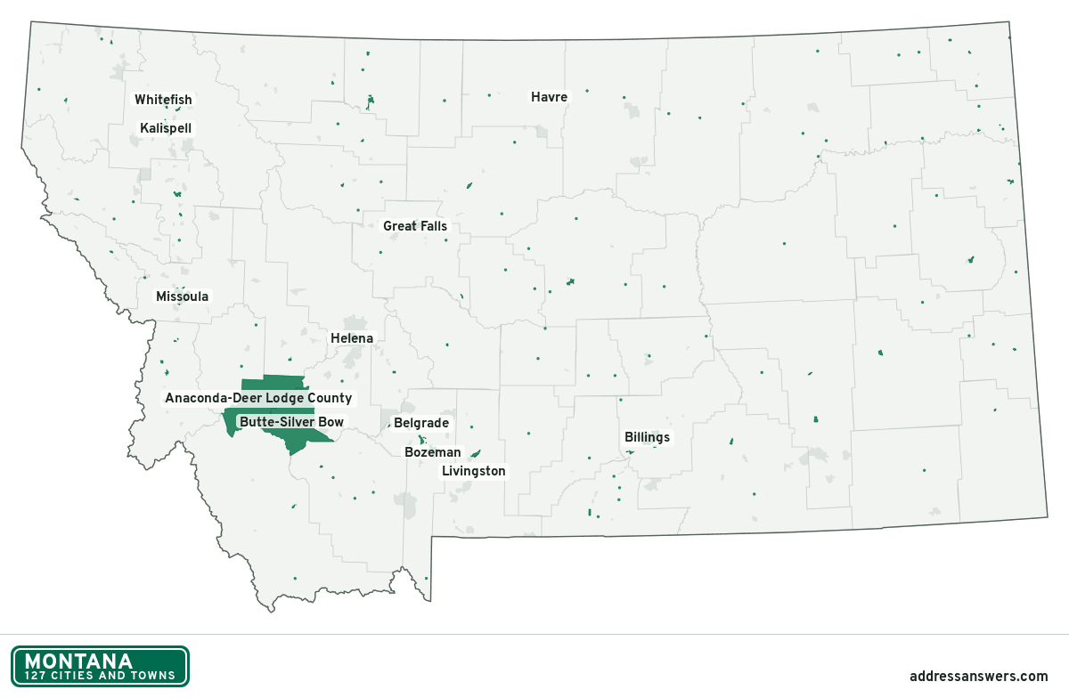
Montana city limits map image
The map above as a picture: every Montana city and town in green, with county lines. Boundaries from the Census Bureau, as of January 1, 2025.
You’re welcome to use it in a document or on your own site, with a link back to this page.
Download the map (PNG, 1,200 × 784)Questions about Montana city limits
How many cities and towns are in Montana?
Montana has 127 incorporated places: 54 cities and 73 towns, by the Census Bureau’s boundary files for 2025.
What is the largest city in Montana?
By population, Billings, with about 119,434 residents (2020–2024 American Community Survey 5-year estimates). By land area the largest is Anaconda-Deer Lodge County, at 736.7 square miles (Billings: 46.3).
What is the smallest town in Montana?
By the Census Bureau’s estimate, Ismay, with 1 resident. Estimates for places this small have a wide margin of error, so treat it as a rough count.
How much of Montana is unincorporated?
99% of its land and 508,708 of its residents (46%) are outside every city or town. There, local government is the county. The state also has 370 named unincorporated communities; the largest is Evergreen.
Is Evergreen, MT a city?
No. Evergreen is a census-designated place: a community the Census Bureau maps for statistics, with no city government of its own. About 9,611 people live there, in unincorporated Flathead County. An address there is outside city limits, even if its mailing address says otherwise.
Is Helena Valley Southeast, MT a city?
No. Helena Valley Southeast is a census-designated place: a community the Census Bureau maps for statistics, with no city government of its own. About 9,108 people live there, in unincorporated Lewis and Clark County. An address there is outside city limits, even if its mailing address says otherwise.
Which county in Montana has the most cities and towns?
Carbon County, with 5 at least partly inside it. Every county in Montana has at least one.
Bordering states
More answers for a Montana address
Each tool checks the same address and puts its own answer first.
- County Census Your county, plus the township or town where those exist. Find your county
- School district Census The public school district that covers the address. Find your school district
- Flood zone FEMA The FEMA zone in plain English, and whether lenders require flood insurance. Check flood zone
- USDA home loans USDA Whether the property is in an area eligible for a USDA Rural Development loan. Check USDA eligibility
- Voting districts Census Your congressional district and your state senate and state house districts. Included in every check
Places, boundaries, land area and counties: US Census Bureau 2025 cartographic boundary files (boundaries as of January 1, 2025). A place is listed in each county that holds at least 1% of its land. Population: 2020–2024 American Community Survey 5-year estimates. Data updated October 24, 2026; page updated October 25, 2026. Boundaries change through annexation; your city or county has the official map.