South Carolina city limits map
South Carolina has 271 incorporated places: 69 cities and 202 towns. They cover 6.4% of the state’s land and are home to 37% of its residents. Everyone else lives outside city limits, where local government is the county. Enter an address to see which side of a city line it’s on.
Result for
The map couldn’t load. The answers don’t depend on it.
The boundary couldn’t load. The answer doesn’t depend on it.
Census Geocoder match
More about this address
Sources and limits
- Census
- US Census Bureau Geocoder, current boundaries
- FEMA
- National Flood Hazard Layer, effective flood maps
- USDA
- Rural Development property eligibility
- Map
- Boundaries from Census TIGERweb, flood zones drawn by FEMA, eligible areas from USDA, base map © OpenStreetMap contributors
Census boundaries are updated once a year, so a recent annexation may not show yet. Informational only, not an official determination. Verify with your city or county.
South Carolina at a glance
- Incorporated places
- 271
- 69 cities and 202 towns
- Residents in city limits
- 37%
- 1,979,499 of 5,296,225
- Land in city limits
- 6.4%
- 1,936 of 30,064 sq mi
- Counties
- 46
- Every one has at least one
- Unincorporated communities
- 204
- Largest: Carolina Forest (26,263)
- Largest city
- Charleston
- 154,338 residents
City limits maps for 3 South Carolina cities
Every South Carolina city with 100,000 or more residents has its own page: the boundary in detail, the places around it and its school districts.
All 271 cities and towns in South Carolina
Every incorporated place, largest first, with the counties it’s in and its size. An address inside one of these is inside city limits; anywhere else in the state is unincorporated.
| Name | Type | County | Population | Land (sq mi) |
|---|---|---|---|---|
| Charleston | City | Charleston, Berkeley | 154,338 | 115.3 |
| Columbia | City | Richland | 139,643 | 139.4 |
| North Charleston | City | Charleston, Dorchester | 119,913 | 78.0 |
| Mount Pleasant | Town | Charleston | 93,993 | 49.8 |
| Rock Hill | City | York | 75,259 | 44.9 |
| Greenville | City | Greenville | 72,935 | 30.9 |
| Summerville | Town | Dorchester, Berkeley +1 | 51,654 | 22.6 |
| Goose Creek | City | Berkeley | 48,078 | 43.5 |
| Sumter | City | Sumter | 43,053 | 33.2 |
| Greer | City | Greenville, Spartanburg | 41,536 | 24.5 |
| Florence | City | Florence | 40,408 | 24.9 |
| Spartanburg | City | Spartanburg | 38,910 | 20.4 |
| Myrtle Beach | City | Horry | 38,371 | 23.4 |
| Hilton Head Island | Town | Beaufort | 37,911 | 41.4 |
| Bluffton | Town | Beaufort | 33,157 | 52.1 |
| Aiken | City | Aiken | 32,521 | 22.1 |
| Fort Mill | Town | York | 30,775 | 19.5 |
| Anderson | City | Anderson | 30,051 | 16.5 |
| Conway | City | Horry | 27,263 | 28.0 |
| Mauldin | City | Greenville | 27,055 | 12.5 |
| Simpsonville | City | Greenville | 26,144 | 9.71 |
| North Augusta | City | Aiken, Edgefield | 25,653 | 21.5 |
| Easley | City | Pickens | 24,841 | 13.0 |
| Lexington | Town | Lexington | 24,585 | 12.6 |
| Greenwood | City | Greenwood | 22,536 | 16.7 |
| Hanahan | City | Berkeley | 21,452 | 10.5 |
| North Myrtle Beach | City | Horry | 19,855 | 22.6 |
| Clemson | City | Pickens, Anderson | 18,072 | 7.95 |
| West Columbia | City | Lexington | 17,963 | 9.42 |
| Port Royal | Town | Beaufort | 15,579 | 19.3 |
| Moncks Corner | Town | Berkeley | 15,485 | 11.5 |
| Beaufort | City | Beaufort | 13,747 | 24.5 |
| Cayce | City | Lexington, Richland | 13,741 | 16.9 |
| Tega Cay | City | York | 13,615 | 4.56 |
| Orangeburg | City | Orangeburg | 13,253 | 9.01 |
| Gaffney | City | Cherokee | 12,596 | 9.64 |
| James Island | Town | Charleston | 12,198 | 4.84 |
| Fountain Inn | City | Greenville, Laurens | 12,020 | 8.62 |
| Irmo | Town | Richland, Lexington | 11,813 | 6.83 |
| Hardeeville | City | Jasper | 10,871 | 60.3 |
| Newberry | City | Newberry | 10,790 | 9.20 |
| Forest Acres | City | Richland | 10,530 | 4.64 |
| Laurens | City | Laurens | 9,336 | 10.2 |
| Seneca | City | Oconee | 8,993 | 8.47 |
| York | City | York | 8,969 | 8.77 |
| Lancaster | City | Lancaster | 8,921 | 8.06 |
| Georgetown | City | Georgetown | 8,565 | 6.99 |
| Travelers Rest | City | Greenville | 8,370 | 6.24 |
| Camden | City | Kershaw | 8,267 | 11.1 |
| Union | City | Union | 8,079 | 8.11 |
| Bennettsville | City | Marlboro | 7,751 | 6.18 |
| Clinton | City | Laurens | 7,676 | 10.6 |
| Hartsville | City | Darlington | 7,419 | 6.02 |
| Clover | Town | York | 7,234 | 4.67 |
| Lyman | Town | Spartanburg | 6,547 | 6.78 |
| Dillon | City | Dillon | 6,354 | 5.44 |
| Marion | City | Marion | 6,206 | 4.48 |
| Darlington | City | Darlington | 6,120 | 4.73 |
| Lake City | City | Florence | 5,988 | 5.47 |
| Blythewood | Town | Richland, Fairfield | 5,731 | 10.6 |
| Walterboro | City | Colleton | 5,480 | 7.10 |
| Hollywood | Town | Charleston | 5,382 | 23.5 |
| Central | Town | Pickens | 5,320 | 5.44 |
| Chester | City | Chester | 5,218 | 4.07 |
| Cheraw | Town | Chesterfield | 4,960 | 5.95 |
| Batesburg-Leesville | Town | Lexington, Saluda | 4,941 | 8.20 |
| Abbeville | City | Abbeville | 4,872 | 6.22 |
| Barnwell | City | Barnwell | 4,613 | 7.84 |
| Woodruff | City | Spartanburg | 4,538 | 7.70 |
| Belton | City | Anderson | 4,458 | 3.84 |
| Isle of Palms | City | Charleston | 4,362 | 4.44 |
| Duncan | Town | Spartanburg | 4,310 | 7.17 |
| Surfside Beach | Town | Horry | 4,270 | 1.95 |
| Williamston | Town | Anderson | 4,170 | 3.85 |
| Walhalla | City | Oconee | 4,157 | 3.89 |
| Edgefield | Town | Edgefield | 4,010 | 4.33 |
| Mullins | City | Marion | 3,914 | 3.19 |
| Manning | City | Clarendon | 3,863 | 2.93 |
| Ridgeland | Town | Jasper, Beaufort | 3,764 | 48.3 |
| Honea Path | Town | Anderson, Abbeville | 3,739 | 3.51 |
| Pendleton | Town | Anderson | 3,594 | 4.91 |
| Wellford | City | Spartanburg | 3,515 | 5.31 |
| Andrews | Town | Georgetown, Williamsburg | 3,485 | 2.21 |
| Liberty | City | Pickens | 3,350 | 4.93 |
| Winnsboro | Town | Fairfield | 3,322 | 5.72 |
| Inman | City | Spartanburg | 3,166 | 1.89 |
| Pickens | City | Pickens | 3,155 | 3.06 |
| Burnettown | Town | Aiken | 3,135 | 5.51 |
| Kingstree | Town | Williamsburg | 3,132 | 3.18 |
| Denmark | City | Bamberg | 3,117 | 3.91 |
| Saluda | Town | Saluda | 3,055 | 3.25 |
| Bamberg | Town | Bamberg | 2,996 | 3.57 |
| Bishopville | City | Lee | 2,910 | 2.34 |
| Williston | Town | Barnwell | 2,870 | 8.95 |
| New Ellenton | Town | Aiken | 2,837 | 4.44 |
| Springdale | Town | Lexington | 2,742 | 2.71 |
| Allendale | Town | Allendale | 2,653 | 3.31 |
| Loris | City | Horry | 2,645 | 4.58 |
| Hampton | Town | Hampton | 2,636 | 4.51 |
| Landrum | City | Spartanburg | 2,620 | 2.85 |
| Ravenel | Town | Charleston | 2,615 | 13.2 |
| Pine Ridge | Town | Lexington | 2,596 | 4.52 |
| Varnville | Town | Hampton | 2,571 | 3.83 |
| Ninety Six | Town | Greenwood | 2,521 | 1.93 |
| Westminster | City | Oconee | 2,521 | 3.55 |
| McCormick | Town | McCormick | 2,506 | 4.05 |
| Pageland | Town | Chesterfield | 2,489 | 4.86 |
| Pacolet | Town | Spartanburg | 2,419 | 5.81 |
| Kiawah Island | Town | Charleston | 2,326 | 11.2 |
| Kershaw | Town | Lancaster | 2,259 | 2.00 |
| Seabrook Island | Town | Charleston | 2,204 | 5.94 |
| McColl | Town | Marlboro | 2,200 | 1.05 |
| Reidville | Town | Spartanburg | 2,194 | 1.83 |
| St. George | Town | Dorchester | 2,154 | 2.85 |
| Johnston | Town | Edgefield | 2,132 | 2.62 |
| Sullivan's Island | Town | Charleston | 2,087 | 2.50 |
| Elgin | Town | Kershaw | 2,080 | 1.08 |
| South Congaree | Town | Lexington | 2,075 | 3.29 |
| Ware Shoals | Town | Greenwood, Laurens | 2,074 | 3.28 |
| Blacksburg | Town | Cherokee | 2,063 | 1.87 |
| Calhoun Falls | Town | Abbeville | 2,049 | 3.39 |
| Timmonsville | Town | Florence | 2,045 | 2.83 |
| Fairfax | Town | Allendale | 1,935 | 3.31 |
| Estill | Town | Hampton | 1,886 | 4.02 |
| Jackson | Town | Aiken | 1,870 | 3.52 |
| Cowpens | Town | Spartanburg | 1,840 | 2.30 |
| Gaston | Town | Lexington | 1,803 | 5.33 |
| Blackville | Town | Barnwell | 1,778 | 8.93 |
| Awendaw | Town | Charleston | 1,772 | 17.4 |
| Ridgeville | Town | Dorchester | 1,740 | 3.05 |
| Pelzer | Town | Anderson | 1,722 | 1.02 |
| Great Falls | Town | Chester | 1,690 | 4.24 |
| St. Matthews | Town | Calhoun | 1,645 | 1.92 |
| Chesterfield | Town | Chesterfield | 1,465 | 4.11 |
| St. Stephen | Town | Berkeley | 1,462 | 2.68 |
| Latta | Town | Dillon | 1,455 | 1.10 |
| Chapin | Town | Lexington | 1,394 | 2.23 |
| Fort Lawn | Town | Chester | 1,388 | 1.39 |
| West Pelzer | Town | Anderson | 1,320 | 0.63 |
| Whitmire | Town | Newberry | 1,319 | 1.25 |
| Prosperity | Town | Newberry | 1,318 | 1.98 |
| Meggett | Town | Charleston | 1,307 | 18.1 |
| Folly Beach | City | Charleston | 1,267 | 12.5 |
| Johnsonville | City | Florence | 1,251 | 2.06 |
| Holly Hill | Town | Orangeburg | 1,218 | 1.75 |
| Cottageville | Town | Colleton | 1,196 | 3.42 |
| Lamar | Town | Darlington | 1,196 | 1.21 |
| Wagener | Town | Aiken | 1,193 | 1.36 |
| Yemassee | Town | Beaufort, Hampton | 1,178 | 12.4 |
| Due West | Town | Abbeville | 1,177 | 1.64 |
| Pamplico | Town | Florence | 1,134 | 1.70 |
| Jonesville | Town | Union | 1,118 | 1.01 |
| Aynor | Town | Horry | 1,112 | 1.80 |
| Edisto Beach | Town | Colleton | 1,092 | 2.13 |
| Branchville | Town | Orangeburg | 1,084 | 3.17 |
| Santee | Town | Orangeburg | 1,076 | 2.36 |
| Lincolnville | Town | Charleston, Dorchester | 1,064 | 1.20 |
| Elloree | Town | Orangeburg | 1,035 | 1.06 |
| Pelion | Town | Lexington | 985 | 4.30 |
| Iva | Town | Anderson | 972 | 1.08 |
| Heath Springs | Town | Lancaster | 955 | 1.61 |
| Van Wyck | Town | Lancaster | 951 | 10.4 |
| Six Mile | Town | Pickens | 931 | 2.04 |
| Turbeville | Town | Clarendon | 925 | 1.34 |
| Arcadia Lakes | Town | Richland | 901 | 0.56 |
| Chesnee | City | Spartanburg, Cherokee | 896 | 1.06 |
| Quinby | Town | Florence | 858 | 1.31 |
| Coward | Town | Florence | 853 | 3.23 |
| Ridge Spring | Town | Saluda | 842 | 1.82 |
| Clio | Town | Marlboro | 840 | 0.86 |
| Mayesville | Town | Sumter | 832 | 1.02 |
| McBee | Town | Chesterfield | 818 | 1.31 |
| Olanta | Town | Florence | 806 | 1.01 |
| Summerton | Town | Clarendon | 803 | 1.35 |
| Norris | Town | Pickens | 784 | 1.88 |
| Gray Court | Town | Laurens | 783 | 1.89 |
| Campobello | Town | Spartanburg | 776 | 2.76 |
| Gilbert | Town | Lexington | 751 | 2.71 |
| Swansea | Town | Lexington | 744 | 2.09 |
| Jefferson | Town | Chesterfield | 737 | 1.80 |
| Scranton | Town | Florence | 733 | 0.79 |
| Bowman | Town | Orangeburg | 691 | 1.18 |
| McClellanville | Town | Charleston | 690 | 2.23 |
| Lake View | Town | Dillon | 679 | 2.23 |
| North | Town | Orangeburg | 675 | 0.86 |
| Furman | Town | Hampton | 673 | 3.12 |
| Pinewood | Town | Sumter | 668 | 1.07 |
| Hemingway | Town | Williamsburg | 660 | 0.86 |
| Harleyville | Town | Dorchester | 592 | 1.48 |
| Bonneau | Town | Berkeley | 581 | 3.02 |
| Lane | Town | Williamsburg | 564 | 3.95 |
| Summit | Town | Lexington | 533 | 1.56 |
| Hickory Grove | Town | York | 528 | 1.71 |
| Neeses | Town | Orangeburg | 524 | 1.71 |
| Cross Hill | Town | Laurens | 514 | 3.19 |
| Carlisle | Town | Union | 494 | 1.42 |
| Eastover | Town | Richland | 485 | 1.31 |
| Hilda | Town | Barnwell | 468 | 3.07 |
| Springfield | Town | Orangeburg | 468 | 1.74 |
| Paxville | Town | Clarendon | 453 | 1.05 |
| Briarcliffe Acres | Town | Horry | 448 | 0.64 |
| Bethune | Town | Kershaw | 438 | 1.10 |
| Sharon | Town | York | 431 | 1.31 |
| Cameron | Town | Calhoun | 427 | 3.12 |
| Lockhart | Town | Union | 405 | 0.32 |
| Brunson | Town | Hampton | 401 | 1.02 |
| Richburg | Town | Chester | 397 | 0.88 |
| Rowesville | Town | Orangeburg | 393 | 0.83 |
| Ehrhardt | Town | Bamberg | 389 | 3.11 |
| Eutawville | Town | Orangeburg | 388 | 1.02 |
| Society Hill | Town | Darlington | 388 | 2.41 |
| West Union | Town | Oconee | 370 | 0.85 |
| Little Mountain | Town | Newberry | 368 | 1.55 |
| Greeleyville | Town | Williamsburg | 362 | 1.22 |
| Donalds | Town | Abbeville | 355 | 0.83 |
| Patrick | Town | Chesterfield | 331 | 0.97 |
| Silverstreet | Town | Newberry | 330 | 3.35 |
| Lynchburg | Town | Lee | 323 | 1.13 |
| Norway | Town | Orangeburg | 322 | 0.79 |
| Luray | Town | Hampton | 311 | 1.03 |
| Windsor | Town | Aiken | 307 | 0.87 |
| Lowrys | Town | Chester | 303 | 3.16 |
| Elko | Town | Barnwell | 296 | 1.05 |
| Salley | Town | Aiken | 288 | 0.77 |
| McConnells | Town | York | 285 | 3.39 |
| Monetta | Town | Saluda, Aiken | 282 | 0.69 |
| Reevesville | Town | Dorchester | 271 | 1.61 |
| Gifford | Town | Hampton | 268 | 0.97 |
| Ridgeway | Town | Fairfield | 261 | 0.48 |
| Ward | Town | Saluda | 260 | 0.78 |
| Starr | Town | Anderson | 258 | 1.52 |
| Trenton | Town | Edgefield | 258 | 1.29 |
| Perry | Town | Aiken | 250 | 0.96 |
| Ruby | Town | Chesterfield | 244 | 2.47 |
| Nichols | Town | Marion | 240 | 1.34 |
| Atlantic Beach | Town | Horry | 237 | 0.16 |
| Snelling | Town | Barnwell | 219 | 4.04 |
| Waterloo | Town | Laurens | 212 | 1.78 |
| Central Pacolet | Town | Spartanburg | 206 | 0.24 |
| Lowndesville | Town | Abbeville | 206 | 0.77 |
| Hodges | Town | Greenwood | 193 | 0.78 |
| Sellers | Town | Marion | 192 | 0.67 |
| Stuckey | Town | Williamsburg | 190 | 0.93 |
| Ulmer | Town | Allendale | 190 | 2.74 |
| Salem | Town | Oconee | 177 | 0.92 |
| Troy | Town | Greenwood | 177 | 0.80 |
| Mount Croghan | Town | Chesterfield | 170 | 0.76 |
| Pawleys Island | Town | Georgetown | 170 | 0.70 |
| Vance | Town | Orangeburg | 166 | 0.51 |
| Kline | Town | Barnwell | 154 | 3.11 |
| Livingston | Town | Orangeburg | 152 | 0.79 |
| Pomaria | Town | Newberry | 152 | 1.05 |
| Olar | Town | Bamberg | 139 | 0.79 |
| Rockville | Town | Charleston | 121 | 0.42 |
| Cordova | Town | Orangeburg | 118 | 0.44 |
| Woodford | Town | Orangeburg | 115 | 0.79 |
| Peak | Town | Newberry | 108 | 0.34 |
| Williams | Town | Colleton | 100 | 0.85 |
| Lodge | Town | Colleton | 98 | 3.14 |
| Scotia | Town | Hampton | 97 | 3.16 |
| Plum Branch | Town | McCormick | 95 | 0.74 |
| Smoaks | Town | Colleton | 95 | 1.63 |
| Blenheim | Town | Marlboro | 82 | 0.65 |
| Parksville | Town | McCormick | 82 | 0.73 |
| Tatum | Town | Marlboro | 80 | 0.91 |
| Jenkinsville | Town | Fairfield | 69 | 0.09 |
| Sycamore | Town | Allendale | 68 | 3.17 |
| Jamestown | Town | Berkeley | 62 | 0.61 |
| Govan | Town | Bamberg | 45 | 0.75 |
| Smyrna | Town | York, Cherokee | 38 | 0.71 |
| Cope | Town | Orangeburg | 15 | 0.25 |
Showing 1–50 of 271
Unincorporated communities in South Carolina
Census-designated places: named communities the Census Bureau maps for statistics, with no city government of their own. An address in one is outside city limits, even when its mailing address names a city. South Carolina has 204.
| Community | County | Population | Land (sq mi) |
|---|---|---|---|
| Carolina Forest | Horry | 26,263 | 16.8 |
| Taylors | Greenville | 24,505 | 10.6 |
| Socastee | Horry | 23,796 | 13.4 |
| Wade Hampton | Greenville | 20,898 | 8.78 |
| St. Andrews | Richland | 19,868 | 6.00 |
| Five Forks | Greenville | 18,656 | 7.57 |
| Berea | Greenville | 16,862 | 7.70 |
| Ladson | Berkeley | 16,140 | 6.93 |
| Lake Wylie | York | 16,006 | 7.91 |
| Seven Oaks | Lexington | 15,921 | 7.73 |
| Red Hill | Horry | 15,920 | 11.0 |
| Gantt | Greenville | 15,401 | 9.57 |
| Dentsville | Richland | 15,209 | 6.62 |
| Boiling Springs | Spartanburg | 12,936 | 6.84 |
| Parker | Greenville | 12,898 | 6.81 |
| Oak Grove | Lexington | 12,256 | 7.57 |
| Little River | Horry | 11,771 | 10.5 |
| Garden City | Horry | 11,591 | 5.35 |
| Red Bank | Lexington | 11,314 | 12.4 |
| Powdersville | Anderson | 10,771 | 13.8 |
| Murrells Inlet | Georgetown | 10,044 | 7.32 |
| Lugoff | Kershaw | 9,786 | 22.8 |
| Woodfield | Richland | 9,465 | 2.72 |
| Litchfield Beach | Georgetown | 9,044 | 11.2 |
| Sangaree | Berkeley | 8,681 | 2.03 |
| White Knoll | Lexington | 8,310 | 6.12 |
| Valley Falls | Spartanburg | 8,239 | 5.19 |
| Sans Souci | Greenville | 7,665 | 3.31 |
| Forestbrook | Horry | 7,479 | 3.67 |
| Centerville | Anderson | 7,049 | 5.90 |
| Lake Murray of Richland | Richland | 7,023 | 5.55 |
| Clemson University | Pickens | 7,015 | 2.12 |
| Burton | Beaufort | 6,912 | 8.25 |
| Homeland Park | Anderson | 6,632 | 4.71 |
| Welcome | Greenville | 6,527 | 4.61 |
| Laurel Bay | Beaufort | 5,882 | 4.16 |
| Piedmont | Anderson | 5,462 | 8.59 |
| Belvedere | Aiken | 5,180 | 3.35 |
| Baxter Village | York | 4,542 | 1.47 |
| Northlake | Anderson | 4,390 | 4.13 |
| Capitol View | Richland | 4,374 | 1.60 |
| Brookdale | Orangeburg | 4,291 | 3.64 |
| East Camden | Kershaw | 4,194 | 3.58 |
| Newport | York | 4,121 | 8.04 |
| Saxon | Spartanburg | 4,085 | 2.38 |
| India Hook | York | 3,960 | 2.64 |
| Southern Shops | Spartanburg | 3,797 | 3.56 |
| Whitney | Spartanburg | 3,685 | 3.05 |
| Dunean | Greenville | 3,668 | 1.56 |
| Wyboo | Clarendon | 3,639 | 15.0 |
| Lakewood | Sumter | 3,544 | 7.53 |
| Arcadia | Spartanburg | 3,426 | 1.96 |
| Keowee Key | Oconee | 3,351 | 3.47 |
| Clearwater | Aiken | 3,319 | 4.19 |
| North Hartsville | Darlington | 3,304 | 4.53 |
| Arthurtown | Richland | 3,272 | 1.86 |
| Lesslie | York | 3,077 | 6.06 |
| Hilltop | Spartanburg | 2,950 | 1.82 |
| Dalzell | Sumter | 2,946 | 5.85 |
| Golden Grove | Greenville | 2,913 | 5.78 |
| Roebuck | Spartanburg | 2,902 | 4.29 |
| East Gaffney | Cherokee | 2,824 | 3.02 |
| Arkwright | Spartanburg | 2,816 | 2.58 |
| Homewood | Horry | 2,708 | 2.03 |
| Cherryvale | Sumter | 2,611 | 1.81 |
| Judson | Greenville | 2,515 | 0.74 |
| Gloverville | Aiken | 2,505 | 3.63 |
| Ben Avon | Spartanburg | 2,487 | 1.67 |
| Privateer | Sumter | 2,472 | 8.17 |
| Slater-Marietta | Greenville | 2,381 | 4.31 |
| Elgin | Lancaster | 2,360 | 4.86 |
| Mayo | Spartanburg | 2,305 | 3.04 |
| Springdale | Lancaster | 2,198 | 3.54 |
| Riverview | York | 2,121 | 1.23 |
| Graniteville | Aiken | 2,056 | 3.34 |
| Stateburg | Sumter | 2,027 | 4.66 |
| Wilkinson Heights | Orangeburg | 2,012 | 2.99 |
| Hopkins | Richland | 1,985 | 16.5 |
| Wedgefield | Sumter | 1,968 | 8.50 |
| Watts Mills | Laurens | 1,942 | 2.23 |
| Arial | Pickens | 1,919 | 4.56 |
| Irwin | Lancaster | 1,919 | 2.99 |
| Tigerville | Greenville | 1,880 | 1.33 |
| Monarch Mill | Union | 1,822 | 5.59 |
| Eureka Mill | Chester | 1,813 | 1.27 |
| Edisto | Orangeburg | 1,801 | 5.27 |
| Pimlico | Berkeley | 1,765 | 0.69 |
| Fairforest | Spartanburg | 1,727 | 2.09 |
| South Sumter | Sumter | 1,626 | 2.34 |
| Camp Croft | Spartanburg | 1,586 | 2.65 |
| Beech Island | Aiken | 1,578 | 4.92 |
| Cane Savannah | Sumter | 1,551 | 3.63 |
| Winnsboro Mills | Fairfield | 1,535 | 2.37 |
| Bonneau Beach | Berkeley | 1,516 | 2.35 |
| Drayton | Spartanburg | 1,452 | 1.36 |
| Gadsden | Richland | 1,443 | 11.5 |
| Shell Point | Beaufort | 1,439 | 3.88 |
| Utica | Oconee | 1,339 | 1.09 |
| Buffalo | Union | 1,329 | 4.02 |
| Langley | Aiken | 1,310 | 1.14 |
| Joanna | Laurens | 1,306 | 3.14 |
| Lake Secession | Abbeville | 1,268 | 5.81 |
| Edmund | Lexington | 1,161 | 6.83 |
| Dovesville | Darlington | 1,120 | 7.01 |
| Sandy Springs | Anderson | 1,105 | 2.87 |
| Catawba | York | 1,071 | 9.96 |
| Murphys Estates | Edgefield | 1,064 | 2.05 |
| Oakland | Sumter | 1,060 | 0.68 |
| Hamer | Dillon | 1,042 | 5.04 |
| Warrenville | Aiken | 1,042 | 1.08 |
| Gayle Mill | Chester | 974 | 0.66 |
| Newtown | Dillon | 972 | 0.52 |
| East Sumter | Sumter | 943 | 3.32 |
| Olympia | Richland | 935 | 0.70 |
| Inman Mills | Spartanburg | 923 | 1.05 |
| Pinopolis | Berkeley | 854 | 1.43 |
| Cateechee | Pickens | 850 | 0.51 |
| Manville | Lee | 827 | 2.72 |
| Seabrook | Beaufort | 799 | 5.50 |
| Clifton | Spartanburg | 792 | 1.07 |
| The Cliffs Valley | Greenville | 789 | 6.46 |
| Conestee | Greenville | 776 | 1.06 |
| Fair Play | Oconee | 757 | 6.77 |
| Cash | Chesterfield | 754 | 1.52 |
| Fripp Island | Beaufort | 752 | 3.26 |
| Bucksport | Horry | 747 | 4.20 |
| City View | Greenville | 746 | 0.38 |
| Helena | Newberry | 716 | 1.42 |
| La France | Anderson | 678 | 1.30 |
| Startex | Spartanburg | 668 | 0.91 |
| Wallace | Marlboro | 665 | 6.57 |
| North Santee | Clarendon | 649 | 9.11 |
| Pine Ridge | Darlington | 637 | 2.27 |
| DeBordieu Colony | Georgetown | 627 | 4.12 |
| Chickasaw Point | Oconee | 620 | 2.19 |
| Daufuskie Island | Beaufort | 619 | 9.81 |
| Sheldon | Beaufort | 610 | 4.35 |
| Dunbar | Georgetown | 577 | 1.02 |
| Modoc | McCormick | 577 | 3.98 |
| Mulberry | Sumter | 474 | 1.96 |
| Adams Run | Charleston | 469 | 1.41 |
| Converse | Spartanburg | 463 | 0.69 |
| Alcolu | Clarendon | 459 | 4.55 |
| Pauline | Spartanburg | 447 | 1.43 |
| South Union | Oconee | 447 | 2.60 |
| Fairview Crossroads | Lexington | 444 | 5.71 |
| Newry | Oconee | 412 | 0.30 |
| Dale | Beaufort | 411 | 2.37 |
| Danwood | Florence | 392 | 1.90 |
| Russellville | Berkeley | 392 | 3.74 |
| Gillisonville | Jasper | 378 | 1.18 |
| Enoree | Spartanburg | 370 | 1.55 |
| Buford | Lancaster | 346 | 2.28 |
| Grover | Dorchester | 345 | 2.59 |
| Finklea | Horry | 340 | 2.69 |
| Jacksonboro | Colleton | 336 | 14.5 |
| Floydale | Dillon | 312 | 2.03 |
| Little Rock | Dillon | 306 | 2.45 |
| Harbor Island | Beaufort | 303 | 1.02 |
| Cokesbury | Greenwood | 267 | 0.59 |
| Daviston | Marion | 262 | 1.29 |
| Mount Carmel | McCormick | 261 | 9.19 |
| Antreville | Abbeville | 260 | 3.88 |
| Unity | Lancaster | 244 | 2.11 |
| Glenn Springs | Spartanburg | 236 | 2.22 |
| Elliott | Lee | 230 | 1.85 |
| Glendale | Spartanburg | 211 | 0.21 |
| Abney Crossroads | Kershaw | 208 | 0.46 |
| Fingerville | Spartanburg | 204 | 0.24 |
| Dacusville | Pickens | 198 | 2.20 |
| Centenary | Marion | 191 | 0.94 |
| Lydia | Darlington | 190 | 2.64 |
| Tradesville | Lancaster | 174 | 2.00 |
| Oswego | Sumter | 172 | 1.21 |
| Wisacky | Lee | 149 | 5.53 |
| Rembert | Sumter | 144 | 3.84 |
| Promised Land | Greenwood | 143 | 1.56 |
| St. Charles | Lee | 139 | 4.23 |
| Willington | McCormick | 138 | 5.95 |
| Mountville | Laurens | 136 | 2.86 |
| Clarks Hill | McCormick | 133 | 3.20 |
| Shiloh | Sumter | 124 | 9.76 |
| Boykin | Kershaw | 122 | 6.88 |
| Ware Place | Greenville | 117 | 0.92 |
| Lobeco | Beaufort | 109 | 2.63 |
| Cross Anchor | Spartanburg | 98 | 0.77 |
| Gramling | Spartanburg | 95 | 1.00 |
| Bradley | Greenwood | 90 | 7.86 |
| Browntown | Lee | 88 | 2.46 |
| Rains | Marion | 84 | 1.34 |
| Zion | Marion | 76 | 0.35 |
| Green Sea | Horry | 71 | 1.76 |
| Islandton | Colleton | 56 | 2.77 |
| Ashwood | Lee | 50 | 3.57 |
| Ketchuptown | Horry | 45 | 2.71 |
| Coosawhatchie | Jasper | 43 | 0.59 |
| Coronaca | Greenwood | 37 | 1.68 |
| Cherokee Falls | Cherokee | 36 | 0.11 |
| Tamassee | Oconee | 35 | 1.16 |
| Live Oak | Horry | 22 | 0.84 |
| Princeton | Laurens | 19 | 0.78 |
| Caesars Head | Greenville | 11 | 1.47 |
| Foreston | Clarendon | 5 | 2.28 |
| Longcreek | Oconee | 0 | 1.90 |
Showing 1–50 of 204
Counties in South Carolina
46 counties, with how many cities and towns have land in each and the largest whose main county it is.
| County | Cities | Largest | Population | Land (sq mi) |
|---|---|---|---|---|
| Greenville County | 6 | Greenville | 548,166 | 785.9 |
| Richland County | 7 | Columbia | 422,117 | 757.3 |
| Charleston County | 17 | Charleston | 420,264 | 918.1 |
| Horry County | 8 | Myrtle Beach | 383,016 | 1,133 |
| Spartanburg County | 14 | Spartanburg | 347,852 | 808.4 |
| Lexington County | 14 | Lexington | 304,887 | 698.5 |
| York County | 9 | Rock Hill | 293,673 | 680.6 |
| Berkeley County | 8 | Goose Creek | 246,802 | 1,104 |
| Anderson County | 10 | Anderson | 210,478 | 713.9 |
| Beaufort County | 6 | Hilton Head Island | 195,289 | 576.0 |
| Aiken County | 10 | Aiken | 174,160 | 1,071 |
| Dorchester County | 7 | Summerville | 167,201 | 568.4 |
| Florence County | 9 | Florence | 137,117 | 800.5 |
| Pickens County | 7 | Easley | 134,629 | 497.0 |
| Sumter County | 3 | Sumter | 104,725 | 665.1 |
| Lancaster County | 4 | Lancaster | 104,475 | 549.2 |
| Orangeburg County | 17 | Orangeburg | 83,253 | 1,106 |
| Oconee County | 5 | Seneca | 80,469 | 626.6 |
| Greenwood County | 5 | Greenwood | 69,489 | 455.6 |
| Laurens County | 7 | Laurens | 68,666 | 712.9 |
| Kershaw County | 3 | Camden | 68,314 | 726.6 |
| Georgetown County | 3 | Georgetown | 64,811 | 813.7 |
| Darlington County | 4 | Hartsville | 62,558 | 560.6 |
| Cherokee County | 4 | Gaffney | 56,647 | 393.0 |
| Chesterfield County | 8 | Cheraw | 43,784 | 799.0 |
| Colleton County | 6 | Walterboro | 38,783 | 1,057 |
| Newberry County | 7 | Newberry | 38,435 | 630.3 |
| Chester County | 5 | Chester | 32,182 | 580.9 |
| Jasper County | 2 | Hardeeville | 32,166 | 655.1 |
| Clarendon County | 4 | Manning | 30,986 | 607.2 |
| Williamsburg County | 6 | Kingstree | 30,282 | 934.2 |
| Marion County | 4 | Marion | 28,664 | 489.4 |
| Dillon County | 3 | Dillon | 27,862 | 405.1 |
| Edgefield County | 4 | Edgefield | 27,476 | 500.7 |
| Union County | 4 | Union | 26,885 | 513.6 |
| Marlboro County | 5 | Bennettsville | 25,975 | 479.9 |
| Abbeville County | 6 | Abbeville | 24,420 | 491.2 |
| Fairfield County | 4 | Winnsboro | 20,550 | 686.3 |
| Barnwell County | 7 | Barnwell | 20,521 | 548.4 |
| Saluda County | 5 | Saluda | 19,131 | 453.2 |
| Hampton County | 9 | Hampton | 18,254 | 560.0 |
| Lee County | 2 | Bishopville | 16,166 | 410.2 |
| Calhoun County | 2 | St. Matthews | 14,182 | 381.1 |
| Bamberg County | 5 | Denmark | 13,042 | 393.4 |
| McCormick County | 3 | McCormick | 9,760 | 358.9 |
| Allendale County | 4 | Allendale | 7,661 | 408.1 |
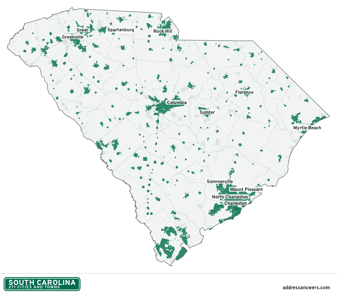
South Carolina city limits map image
The map above as a picture: every South Carolina city and town in green, with county lines. Boundaries from the Census Bureau, as of January 1, 2025.
You’re welcome to use it in a document or on your own site, with a link back to this page.
Download the map (PNG, 1,110 × 972)Questions about South Carolina city limits
How many cities and towns are in South Carolina?
South Carolina has 271 incorporated places: 69 cities and 202 towns, by the Census Bureau’s boundary files for 2025.
What is the largest city in South Carolina?
By population, Charleston, with about 154,338 residents (2020–2024 American Community Survey 5-year estimates). By land area the largest is Columbia, at 139.4 square miles (Charleston: 115.3).
What is the smallest town in South Carolina?
By the Census Bureau’s estimate, Cope, with 15 residents. Estimates for places this small have a wide margin of error, so treat it as a rough count.
How much of South Carolina is unincorporated?
94% of its land and 3.3 million of its residents (63%) are outside every city or town. There, local government is the county. The state also has 204 named unincorporated communities; the largest is Carolina Forest.
Is Carolina Forest, SC a city?
No. Carolina Forest is a census-designated place: a community the Census Bureau maps for statistics, with no city government of its own. About 26,263 people live there, in unincorporated Horry County. An address there is outside city limits, even if its mailing address says otherwise.
Is Taylors, SC a city?
No. Taylors is a census-designated place: a community the Census Bureau maps for statistics, with no city government of its own. About 24,505 people live there, in unincorporated Greenville County. An address there is outside city limits, even if its mailing address says otherwise.
Which cities and towns in South Carolina are in more than one county?
20 of the 271 cross a county line, by at least 1% of their land. The largest: Charleston (Charleston and Berkeley), North Charleston (Charleston and Dorchester), and Summerville (Dorchester, Berkeley, and Charleston). Check an address to see which county it’s in.
Which county in South Carolina has the most cities and towns?
Charleston County, with 17 at least partly inside it. Every county in South Carolina has at least one.
Bordering states
More answers for a South Carolina address
Each tool checks the same address and puts its own answer first.
- County Census Your county, plus the township or town where those exist. Find your county
- School district Census The public school district that covers the address. Find your school district
- Flood zone FEMA The FEMA zone in plain English, and whether lenders require flood insurance. Check flood zone
- USDA home loans USDA Whether the property is in an area eligible for a USDA Rural Development loan. Check USDA eligibility
- Voting districts Census Your congressional district and your state senate and state house districts. Included in every check
Places, boundaries, land area and counties: US Census Bureau 2025 cartographic boundary files (boundaries as of January 1, 2025). A place is listed in each county that holds at least 1% of its land. Population: 2020–2024 American Community Survey 5-year estimates. Data updated October 24, 2026; page updated October 25, 2026. Boundaries change through annexation; your city or county has the official map.