Louisiana city limits map
Louisiana has 305 incorporated places: 70 cities, 128 towns, and 107 villages. They cover 4.3% of the state’s land and are home to 46% of its residents. Everyone else lives outside city limits, where local government is the parish. Enter an address to see which side of a city line it’s on.
Result for
The map couldn’t load. The answers don’t depend on it.
The boundary couldn’t load. The answer doesn’t depend on it.
Census Geocoder match
More about this address
Sources and limits
- Census
- US Census Bureau Geocoder, current boundaries
- FEMA
- National Flood Hazard Layer, effective flood maps
- USDA
- Rural Development property eligibility
- Map
- Boundaries from Census TIGERweb, flood zones drawn by FEMA, eligible areas from USDA, base map © OpenStreetMap contributors
Census boundaries are updated once a year, so a recent annexation may not show yet. Informational only, not an official determination. Verify with your city or county.
Louisiana at a glance
- Incorporated places
- 305
- 70 cities, 128 towns, and 107 villages
- Residents in city limits
- 46%
- 2,141,377 of 4,611,961
- Land in city limits
- 4.3%
- 1,862 of 43,215 sq mi
- Parishes
- 64
- 5 with no municipality
- Unincorporated communities
- 179
- Largest: Metairie (139,729)
- Largest city
- New Orleans
- 371,853 residents
How local government works in Louisiana
Louisiana has parishes instead of counties. They do the same job, so a Louisiana result names a parish.
City limits maps for 4 Louisiana cities
Every Louisiana city with 100,000 or more residents has its own page: the boundary in detail, the places around it and its school districts.
All 305 municipalities in Louisiana
Every incorporated place, largest first, with the parishes it’s in and its size. An address inside one of these is inside city limits; anywhere else in the state is unincorporated.
| Name | Type | Parish | Population | Land (sq mi) |
|---|---|---|---|---|
| New Orleans | City | Orleans | 371,853 | 169.6 |
| Baton Rouge | City | East Baton Rouge | 222,771 | 86.4 |
| Shreveport | City | Caddo, Bossier | 180,982 | 108.2 |
| Lafayette | City | Lafayette | 121,715 | 56.4 |
| Lake Charles | City | Calcasieu | 81,143 | 47.5 |
| Kenner | City | Jefferson | 64,904 | 14.9 |
| Bossier City | City | Bossier | 62,901 | 44.4 |
| Monroe | City | Ouachita | 47,004 | 29.9 |
| Alexandria | City | Rapides | 44,060 | 28.5 |
| Houma | City | Terrebonne | 32,392 | 14.5 |
| Central | City | East Baton Rouge | 29,783 | 62.3 |
| Slidell | City | St. Tammany | 28,561 | 15.2 |
| New Iberia | City | Iberia | 27,571 | 11.1 |
| Ruston | City | Lincoln | 22,284 | 21.2 |
| Hammond | City | Tangipahoa | 21,539 | 14.3 |
| Sulphur | City | Calcasieu | 20,775 | 11.2 |
| Zachary | City | East Baton Rouge | 19,952 | 26.9 |
| Natchitoches | City | Natchitoches | 17,577 | 23.2 |
| Youngsville | City | Lafayette | 17,427 | 12.5 |
| Gretna | City | Jefferson | 17,389 | 4.04 |
| Thibodaux | City | Lafourche | 15,732 | 6.79 |
| Opelousas | City | St. Landry | 15,495 | 9.67 |
| Broussard | City | Lafayette, St. Martin | 14,322 | 18.2 |
| Pineville | City | Rapides | 14,160 | 12.6 |
| Gonzales | City | Ascension | 13,108 | 9.16 |
| Mandeville | City | St. Tammany | 12,946 | 9.25 |
| West Monroe | City | Ouachita | 12,729 | 8.03 |
| Baker | City | East Baton Rouge | 12,253 | 8.43 |
| Covington | City | St. Tammany | 11,658 | 8.05 |
| Carencro | City | Lafayette | 11,619 | 7.86 |
| Minden | City | Webster | 11,455 | 15.0 |
| Crowley | City | Acadia | 11,422 | 5.85 |
| Morgan City | City | St. Mary, St. Martin | 11,064 | 5.98 |
| Abbeville | City | Vermilion | 11,003 | 6.06 |
| Bogalusa | City | Washington | 10,468 | 9.50 |
| DeRidder | City | Beauregard, Vernon | 9,763 | 9.29 |
| Jennings | City | Jefferson Davis | 9,553 | 10.6 |
| Denham Springs | City | Livingston | 9,323 | 7.32 |
| Eunice | City | St. Landry, Acadia | 9,239 | 5.14 |
| Bastrop | City | Morehouse | 9,232 | 8.56 |
| Harahan | City | Jefferson | 8,904 | 2.02 |
| Scott | City | Lafayette | 8,609 | 11.7 |
| Westwego | City | Jefferson | 8,335 | 3.12 |
| Ponchatoula | City | Tangipahoa | 7,808 | 4.72 |
| Breaux Bridge | City | St. Martin | 7,501 | 7.72 |
| Addis | Town | West Baton Rouge | 7,252 | 4.20 |
| Rayne | City | Acadia | 7,105 | 3.82 |
| Donaldsonville | City | Ascension | 6,831 | 3.78 |
| St. Gabriel | City | Iberville | 6,639 | 29.7 |
| Oakdale | City | Allen | 6,546 | 5.19 |
| Franklin | City | St. Mary | 6,461 | 9.96 |
| Walker | Town | Livingston | 6,390 | 6.59 |
| Ville Platte | City | Evangeline | 6,253 | 4.02 |
| Plaquemine | City | Iberville | 6,075 | 2.92 |
| Tallulah | City | Madison | 5,969 | 2.78 |
| Patterson | City | St. Mary | 5,744 | 2.52 |
| Leesville | City | Vernon | 5,495 | 8.91 |
| St. Martinville | City | St. Martin | 5,297 | 3.17 |
| Grambling | City | Lincoln | 5,287 | 5.94 |
| Port Allen | City | West Baton Rouge | 4,942 | 2.83 |
| Marksville | City | Avoyelles | 4,905 | 4.81 |
| Westlake | City | Calcasieu | 4,743 | 3.82 |
| Winnsboro | City | Franklin | 4,725 | 4.00 |
| Jeanerette | City | Iberia | 4,655 | 2.31 |
| Mansfield | City | De Soto | 4,619 | 3.65 |
| Berwick | Town | St. Mary | 4,607 | 5.90 |
| Springhill | City | Webster | 4,599 | 6.21 |
| Haughton | Town | Bossier | 4,485 | 5.72 |
| New Roads | City | Pointe Coupee | 4,404 | 4.58 |
| Kaplan | City | Vermilion | 4,238 | 2.33 |
| Jena | Town | LaSalle | 4,160 | 5.50 |
| Church Point | Town | Acadia | 4,096 | 2.89 |
| Jonesboro | Town | Jackson | 4,063 | 4.85 |
| Amite City | Town | Tangipahoa | 4,048 | 3.88 |
| Winnfield | City | Winn | 4,021 | 3.64 |
| Jackson | Town | East Feliciana | 3,958 | 4.46 |
| Vidalia | Town | Concordia | 3,928 | 2.59 |
| Ball | Town | Rapides | 3,869 | 7.95 |
| Richwood | Town | Ouachita | 3,839 | 2.53 |
| Franklinton | Town | Washington | 3,602 | 4.37 |
| Blanchard | Town | Caddo | 3,437 | 3.47 |
| Farmerville | Town | Union | 3,407 | 5.78 |
| Lake Providence | Town | East Carroll | 3,349 | 3.59 |
| Welsh | Town | Jefferson Davis | 3,313 | 6.32 |
| Rayville | Town | Richland | 3,261 | 2.31 |
| Bunkie | City | Avoyelles | 3,253 | 3.02 |
| Iowa | Town | Calcasieu | 3,200 | 3.40 |
| Vinton | Town | Calcasieu | 3,176 | 5.10 |
| Greenwood | Town | Caddo | 3,110 | 8.99 |
| Ferriday | Town | Concordia | 3,098 | 1.63 |
| Sunset | Town | St. Landry | 3,074 | 3.23 |
| Lutcher | Town | St. James | 2,991 | 3.37 |
| Vivian | Town | Caddo | 2,975 | 5.52 |
| DeQuincy | City | Calcasieu | 2,931 | 3.19 |
| Mamou | Town | Evangeline | 2,864 | 1.41 |
| Gramercy | Town | St. James | 2,814 | 2.01 |
| Abita Springs | Town | St. Tammany | 2,699 | 4.61 |
| Homer | Town | Claiborne | 2,654 | 4.65 |
| Arcadia | Town | Bienville | 2,635 | 3.65 |
| Lockport | Town | Lafourche | 2,618 | 1.13 |
| Pearl River | Town | St. Tammany | 2,614 | 3.80 |
| Brusly | Town | West Baton Rouge | 2,593 | 2.21 |
| Lake Arthur | Town | Jefferson Davis | 2,585 | 1.85 |
| Maurice | Village | Vermilion | 2,584 | 2.90 |
| Delhi | Town | Richland | 2,573 | 2.87 |
| Delcambre | Town | Vermilion, Iberia | 2,552 | 1.17 |
| Benton | Town | Bossier | 2,548 | 2.52 |
| Haynesville | Town | Claiborne | 2,515 | 4.83 |
| Woodworth | Town | Rapides | 2,432 | 8.88 |
| Stonewall | Town | De Soto | 2,392 | 8.57 |
| Kinder | Town | Allen | 2,317 | 5.53 |
| Port Barre | Town | St. Landry | 2,275 | 1.08 |
| Jean Lafitte | Town | Jefferson | 2,266 | 5.85 |
| White Castle | Town | Iberville | 2,237 | 0.73 |
| Sterlington | Town | Ouachita | 2,229 | 2.83 |
| Independence | Town | Tangipahoa | 2,207 | 2.42 |
| Sorrento | Town | Ascension | 2,203 | 3.63 |
| Many | Town | Sabine | 2,166 | 3.41 |
| New Llano | Town | Vernon | 2,144 | 2.67 |
| Kentwood | Town | Tangipahoa | 2,087 | 7.11 |
| Baldwin | Town | St. Mary | 1,962 | 3.22 |
| Coushatta | Town | Red River | 1,938 | 3.34 |
| Erath | Town | Vermilion | 1,907 | 1.76 |
| Cottonport | Town | Avoyelles | 1,858 | 2.01 |
| Golden Meadow | Town | Lafourche | 1,854 | 2.45 |
| Oberlin | Town | Allen | 1,809 | 4.38 |
| St. Francisville | Town | West Feliciana | 1,805 | 1.83 |
| Zwolle | Town | Sabine | 1,796 | 4.56 |
| Basile | Town | Evangeline | 1,790 | 1.16 |
| Henderson | Town | St. Martin | 1,779 | 2.99 |
| Livingston | Town | Livingston | 1,747 | 3.22 |
| Rosepine | Town | Vernon | 1,702 | 2.43 |
| Killian | Town | Livingston | 1,694 | 10.9 |
| Simmesport | Town | Avoyelles | 1,625 | 2.17 |
| Iota | Town | Acadia | 1,481 | 1.27 |
| Gueydan | Town | Vermilion | 1,464 | 0.91 |
| Logansport | Town | De Soto | 1,439 | 3.40 |
| Ringgold | Town | Bienville | 1,405 | 2.32 |
| Leonville | Town | St. Landry | 1,395 | 2.73 |
| Sibley | Town | Webster | 1,376 | 3.89 |
| Bernice | Town | Union | 1,355 | 3.24 |
| Choudrant | Village | Lincoln | 1,319 | 4.23 |
| French Settlement | Village | Livingston | 1,295 | 2.73 |
| Jonesville | Town | Catahoula | 1,288 | 1.92 |
| Glenmora | Town | Rapides | 1,284 | 1.73 |
| Duson | Town | Lafayette, Acadia | 1,282 | 2.99 |
| Oak Grove | Town | West Carroll | 1,264 | 1.72 |
| Mansura | Town | Avoyelles | 1,263 | 2.85 |
| Slaughter | Town | East Feliciana | 1,250 | 5.47 |
| Colfax | Town | Grant | 1,240 | 1.49 |
| Urania | Town | LaSalle | 1,240 | 1.37 |
| Arnaudville | Town | St. Landry, St. Martin | 1,239 | 0.69 |
| Oil City | Town | Caddo | 1,184 | 1.88 |
| Olla | Town | LaSalle | 1,179 | 3.93 |
| Clinton | Town | East Feliciana | 1,136 | 2.74 |
| Morse | Village | Acadia | 1,099 | 1.40 |
| Livonia | Town | Pointe Coupee | 1,097 | 1.89 |
| Roseland | Town | Tangipahoa | 1,070 | 2.12 |
| Campti | Town | Natchitoches | 1,047 | 1.04 |
| Boyce | Town | Rapides | 1,037 | 0.51 |
| Rosedale | Village | Iberville | 1,034 | 7.78 |
| Ridgecrest | Town | Concordia | 1,007 | 0.43 |
| Merryville | Town | Beauregard | 1,004 | 9.79 |
| Newellton | Town | Tensas | 997 | 0.76 |
| Greensburg | Town | St. Helena | 994 | 2.52 |
| Albany | Town | Livingston | 991 | 1.34 |
| Wisner | Town | Franklin | 965 | 0.80 |
| Parks | Village | St. Martin | 963 | 0.85 |
| Grand Coteau | Town | St. Landry | 959 | 2.42 |
| Montgomery | Town | Grant | 941 | 2.07 |
| Fordoche | Town | Pointe Coupee | 934 | 2.43 |
| Pine Prairie | Village | Evangeline | 934 | 1.61 |
| Plain Dealing | Town | Bossier | 929 | 1.58 |
| Anacoco | Village | Vernon | 889 | 3.08 |
| Madisonville | Town | St. Tammany | 869 | 2.53 |
| Elton | Town | Jefferson Davis | 862 | 1.66 |
| Tickfaw | Village | Tangipahoa | 857 | 1.62 |
| Simsboro | Village | Lincoln | 851 | 3.48 |
| Wilson | Village | East Feliciana | 838 | 2.71 |
| Loreauville | Village | Iberia | 833 | 0.43 |
| Krotz Springs | Town | St. Landry | 831 | 1.67 |
| Hessmer | Village | Avoyelles | 828 | 0.83 |
| Moreauville | Village | Avoyelles | 773 | 3.03 |
| Clarks | Village | Caldwell | 770 | 0.96 |
| Cullen | Town | Webster | 758 | 1.15 |
| Maringouin | Town | Iberville | 752 | 0.74 |
| Forest Hill | Village | Rapides | 727 | 3.76 |
| Doyline | Village | Webster | 725 | 3.33 |
| Sarepta | Town | Webster | 724 | 1.63 |
| Florien | Village | Sabine | 714 | 2.23 |
| Dubach | Town | Lincoln | 709 | 1.82 |
| Folsom | Village | St. Tammany | 709 | 1.99 |
| Cotton Valley | Town | Webster | 701 | 2.63 |
| Mooringsport | Town | Caddo | 688 | 1.29 |
| Gibsland | Town | Bienville | 681 | 2.63 |
| Port Vincent | Village | Livingston | 673 | 1.70 |
| Martin | Village | Red River | 667 | 11.5 |
| Mangham | Town | Richland | 638 | 1.11 |
| Mermentau | Village | Acadia | 627 | 2.13 |
| Grand Isle | Town | Jefferson | 623 | 6.40 |
| Estherwood | Village | Acadia | 622 | 1.86 |
| Grayson | Village | Caldwell | 613 | 1.27 |
| Pleasant Hill | Village | Sabine | 605 | 1.62 |
| St. Joseph | Town | Tensas | 603 | 0.89 |
| Morganza | Village | Pointe Coupee | 600 | 1.21 |
| Hodge | Village | Jackson | 597 | 0.97 |
| Lecompte | Town | Rapides | 592 | 1.06 |
| Melville | Town | St. Landry | 589 | 1.26 |
| Vienna | Town | Lincoln | 587 | 3.47 |
| Waterproof | Town | Tensas | 576 | 0.70 |
| Provencal | Village | Natchitoches | 564 | 2.46 |
| Washington | Town | St. Landry | 564 | 0.83 |
| Cheneyville | Town | Rapides | 559 | 1.02 |
| Marion | Town | Union | 539 | 3.21 |
| Chatham | Town | Jackson | 534 | 0.99 |
| Junction City | Village | Union, Claiborne | 525 | 1.23 |
| Tangipahoa | Village | Tangipahoa | 522 | 1.00 |
| Cankton | Village | St. Landry | 514 | 2.04 |
| Napoleonville | Village | Assumption | 511 | 0.17 |
| North Hodge | Village | Jackson | 493 | 0.68 |
| Pioneer | Village | West Carroll | 487 | 1.09 |
| Forest | Village | West Carroll | 486 | 1.67 |
| South Mansfield | Village | De Soto | 475 | 0.68 |
| Epps | Village | West Carroll | 467 | 0.97 |
| Pollock | Town | Grant | 460 | 7.84 |
| Converse | Village | Sabine | 455 | 2.18 |
| Turkey Creek | Village | Evangeline | 449 | 2.48 |
| Richmond | Village | Madison | 447 | 1.66 |
| Noble | Village | Sabine | 445 | 1.03 |
| Mer Rouge | Village | Morehouse | 437 | 1.17 |
| Varnado | Village | Washington | 425 | 0.85 |
| Hornbeck | Town | Vernon | 412 | 1.15 |
| Goldonna | Village | Natchitoches | 404 | 13.1 |
| Simpson | Village | Vernon | 395 | 8.12 |
| Dodson | Village | Winn | 389 | 2.51 |
| Kilbourne | Village | West Carroll | 384 | 1.39 |
| Springfield | Town | Livingston | 382 | 1.40 |
| Sun | Village | St. Tammany | 381 | 4.27 |
| Elizabeth | Village | Allen | 373 | 1.65 |
| Dry Prong | Village | Grant | 369 | 1.39 |
| Chataignier | Village | Evangeline | 367 | 0.63 |
| Athens | Village | Claiborne | 358 | 3.50 |
| Natchez | Village | Natchitoches | 351 | 1.03 |
| Collinston | Village | Morehouse | 347 | 1.13 |
| Columbia | Town | Caldwell | 345 | 0.76 |
| Georgetown | Village | Grant | 340 | 1.30 |
| Norwood | Village | East Feliciana | 340 | 4.08 |
| Dubberly | Village | Webster | 339 | 3.94 |
| Sicily Island | Village | Catahoula | 336 | 0.57 |
| Hosston | Village | Caddo | 333 | 2.66 |
| Castor | Village | Bienville | 325 | 1.19 |
| Quitman | Village | Jackson | 321 | 0.93 |
| Clarence | Village | Natchitoches | 317 | 1.57 |
| Angie | Village | Washington | 313 | 1.53 |
| Dixie Inn | Village | Webster | 300 | 0.49 |
| Evergreen | Town | Avoyelles | 297 | 1.02 |
| Gilbert | Village | Franklin | 294 | 1.05 |
| Grosse Tete | Village | Iberville | 293 | 1.47 |
| Harrisonburg | Village | Catahoula | 287 | 0.97 |
| Sikes | Village | Winn | 279 | 1.56 |
| East Hodge | Village | Jackson | 273 | 0.23 |
| Clayton | Town | Concordia | 272 | 1.58 |
| Ida | Village | Caddo | 254 | 1.42 |
| Lisbon | Village | Claiborne | 251 | 13.1 |
| McNary | Village | Rapides | 248 | 1.84 |
| Grand Cane | Village | De Soto | 227 | 1.13 |
| Tullos | Town | LaSalle | 226 | 1.58 |
| Downsville | Village | Union, Lincoln | 223 | 0.74 |
| Reeves | Village | Allen | 223 | 2.42 |
| Hall Summit | Village | Red River | 222 | 1.67 |
| Creola | Village | Grant | 221 | 0.41 |
| Fenton | Village | Jefferson Davis | 207 | 0.48 |
| Eros | Town | Jackson | 206 | 1.00 |
| Montpelier | Village | St. Helena | 206 | 1.87 |
| Belcher | Village | Caddo | 204 | 1.57 |
| Edgefield | Village | Red River | 203 | 0.25 |
| Lucky | Village | Bienville | 196 | 8.17 |
| Plaucheville | Village | Avoyelles | 193 | 1.51 |
| Atlanta | Village | Winn | 190 | 1.08 |
| Saline | Village | Bienville | 188 | 1.19 |
| Fisher | Village | Sabine | 176 | 0.62 |
| Delta | Village | Madison | 174 | 4.44 |
| Rodessa | Village | Caddo | 173 | 1.20 |
| Calvin | Village | Winn | 169 | 2.29 |
| Keachi | Town | De Soto | 168 | 5.03 |
| Jamestown | Village | Bienville | 165 | 1.75 |
| Bonita | Village | Morehouse | 164 | 1.35 |
| Longstreet | Village | De Soto | 160 | 2.05 |
| Ashland | Village | Natchitoches | 151 | 27.0 |
| Baskin | Village | Franklin | 143 | 1.33 |
| Mount Lebanon | Town | Bienville | 143 | 4.03 |
| Bryceland | Village | Bienville | 139 | 2.33 |
| Heflin | Village | Webster | 139 | 1.91 |
| Stanley | Village | De Soto | 136 | 2.17 |
| Bienville | Village | Bienville | 134 | 11.0 |
| Lillie | Village | Union | 133 | 1.93 |
| Palmetto | Village | St. Landry | 119 | 0.89 |
| Gilliam | Village | Caddo | 117 | 2.37 |
| Robeline | Village | Natchitoches | 110 | 1.19 |
| Spearsville | Village | Union | 93 | 2.37 |
| Shongaloo | Village | Webster | 85 | 7.90 |
| Mound | Village | Madison | 67 | 0.52 |
| Oak Ridge | Village | Morehouse | 63 | 0.99 |
| Powhatan | Village | Natchitoches | 35 | 0.54 |
| St. George | City | East Baton Rouge | – | 59.7 |
Showing 1–50 of 305
Unincorporated communities in Louisiana
Census-designated places: named communities the Census Bureau maps for statistics, with no city government of their own. An address in one is outside city limits, even when its mailing address names a city. Louisiana has 179.
| Community | Parish | Population | Land (sq mi) |
|---|---|---|---|
| Metairie | Jefferson | 139,729 | 23.2 |
| Prairieville | Ascension | 35,238 | 22.0 |
| Marrero | Jefferson | 32,540 | 7.20 |
| Laplace | St. John the Baptist | 28,343 | 20.9 |
| Terrytown | Jefferson | 24,726 | 3.66 |
| Chalmette | St. Bernard | 22,616 | 7.17 |
| Bayou Cane | Terrebonne | 21,253 | 7.61 |
| Harvey | Jefferson | 20,915 | 6.49 |
| Estelle | Jefferson | 16,341 | 4.64 |
| Luling | St. Charles | 13,960 | 23.3 |
| River Ridge | Jefferson | 13,312 | 2.80 |
| Claiborne | Ouachita | 13,308 | 9.96 |
| Moss Bluff | Calcasieu | 12,482 | 15.2 |
| Gardere | East Baton Rouge | 12,223 | 3.34 |
| Bayou Blue | Lafourche | 12,218 | 23.3 |
| Woodmere | Jefferson | 11,879 | 3.65 |
| Destrehan | St. Charles | 11,619 | 5.74 |
| Waggaman | Jefferson | 11,330 | 5.73 |
| Belle Chasse | Plaquemines | 10,934 | 8.17 |
| Timberlane | Jefferson | 10,886 | 1.50 |
| Jefferson | Jefferson | 9,703 | 2.71 |
| Raceland | Lafourche | 9,585 | 21.6 |
| Merrydale | East Baton Rouge | 9,490 | 4.24 |
| Meraux | St. Bernard | 7,918 | 4.15 |
| Reserve | St. John the Baptist | 7,791 | 14.6 |
| Eden Isle | St. Tammany | 7,683 | 3.04 |
| St. Rose | St. Charles | 7,644 | 6.61 |
| Bridge City | Jefferson | 7,297 | 4.18 |
| Prien | Calcasieu | 7,119 | 5.33 |
| Schriever | Terrebonne | 6,690 | 14.3 |
| Red Chute | Bossier | 6,526 | 9.22 |
| Lacombe | St. Tammany | 6,310 | 26.4 |
| Elmwood | Jefferson | 6,077 | 3.77 |
| Galliano | Lafourche | 5,906 | 11.1 |
| Larose | Lafourche | 5,515 | 10.9 |
| Chackbay | Lafourche | 5,436 | 27.7 |
| Cut Off | Lafourche | 5,398 | 14.6 |
| Gray | Terrebonne | 5,154 | 11.5 |
| Arabi | St. Bernard | 4,625 | 1.75 |
| Avondale | Jefferson | 4,608 | 5.56 |
| Eastwood | Bossier | 4,440 | 6.35 |
| Carlyss | Calcasieu | 4,412 | 11.1 |
| Brownsville | Ouachita | 4,357 | 3.47 |
| Brownfields | East Baton Rouge | 4,261 | 4.14 |
| Violet | St. Bernard | 4,122 | 3.93 |
| Swartz | Ouachita | 4,110 | 8.13 |
| Monticello | East Baton Rouge | 3,999 | 2.39 |
| Bayou Vista | St. Mary | 3,842 | 1.80 |
| Hahnville | St. Charles | 3,520 | 5.56 |
| Lakeshore | Ouachita | 3,437 | 0.85 |
| South Vacherie | St. James | 2,954 | 5.08 |
| Bawcomville | Ouachita | 2,804 | 3.17 |
| Milton | Lafayette | 2,793 | 4.62 |
| Lafourche Crossing | Lafourche | 2,790 | 4.21 |
| Norco | St. Charles | 2,781 | 3.45 |
| Chauvin | Terrebonne | 2,502 | 4.76 |
| Erwinville | West Baton Rouge | 2,420 | 9.52 |
| Natalbany | Tangipahoa | 2,416 | 4.43 |
| Des Allemands | St. Charles | 2,382 | 9.95 |
| Grand Point | St. James | 2,341 | 4.29 |
| Pierre Part | Assumption | 2,308 | 3.07 |
| New Orleans Station | Plaquemines | 2,307 | 5.20 |
| Ossun | Lafayette | 2,271 | 3.39 |
| Poydras | St. Bernard | 2,260 | 3.91 |
| Bourg | Terrebonne | 2,239 | 5.65 |
| Bayou L'Ourse | Assumption | 2,132 | 2.72 |
| Garyville | St. John the Baptist | 2,119 | 14.3 |
| Montz | St. Charles | 2,074 | 2.77 |
| Presquille | Terrebonne | 2,062 | 0.78 |
| Boutte | St. Charles | 2,027 | 13.8 |
| Bayou Gauche | St. Charles | 1,908 | 12.9 |
| North Vacherie | St. James | 1,905 | 5.62 |
| Paulina | St. James | 1,785 | 4.62 |
| Cecilia | St. Martin | 1,742 | 2.12 |
| Amelia | St. Mary | 1,712 | 2.52 |
| Cade | St. Martin | 1,710 | 6.72 |
| Mathews | Lafourche | 1,598 | 3.98 |
| Port Sulphur | Plaquemines | 1,593 | 5.41 |
| Deville | Rapides | 1,572 | 13.1 |
| Vienna Bend | Natchitoches | 1,502 | 2.16 |
| Bayou Country Club | Lafourche | 1,497 | 0.78 |
| Ama | St. Charles | 1,483 | 3.50 |
| Edgard | St. John the Baptist | 1,482 | 11.4 |
| Lockport Heights | Lafourche | 1,481 | 1.31 |
| Charenton | St. Mary | 1,440 | 4.97 |
| Minorca | Concordia | 1,430 | 4.47 |
| Perry | Vermilion | 1,424 | 1.75 |
| Labadieville | Assumption | 1,408 | 3.89 |
| Banks Springs | Caldwell | 1,406 | 3.13 |
| Belle Rose | Assumption | 1,400 | 5.36 |
| Watson | Livingston | 1,357 | 0.96 |
| Fifth Ward | Avoyelles | 1,277 | 5.20 |
| Montegut | Terrebonne | 1,266 | 4.21 |
| New Sarpy | St. Charles | 1,247 | 1.36 |
| Lawtell | St. Landry | 1,171 | 4.15 |
| Ventress | Pointe Coupee | 1,166 | 2.03 |
| Kraemer | Lafourche | 1,065 | 5.25 |
| Egan | Acadia | 1,015 | 4.85 |
| Paincourtville | Assumption | 1,008 | 1.74 |
| Empire | Plaquemines | 988 | 5.22 |
| Midway | LaSalle | 937 | 3.03 |
| Hackberry | Cameron | 899 | 28.1 |
| Start | Richland | 852 | 3.52 |
| Lemannville | Ascension | 841 | 1.01 |
| Supreme | Assumption | 803 | 3.39 |
| Welcome | St. James | 796 | 4.54 |
| Good Pine | LaSalle | 791 | 0.77 |
| Wallace | St. John the Baptist | 791 | 6.45 |
| Lakeview | Caddo | 781 | 0.82 |
| Oretta | Beauregard | 733 | 2.20 |
| Lydia | Iberia | 713 | 1.70 |
| Hayes | Calcasieu | 690 | 2.78 |
| Centerville | St. Mary | 685 | 0.94 |
| Gillis | Calcasieu | 667 | 1.67 |
| Hester | St. James | 654 | 3.46 |
| Reddell | Evangeline | 653 | 3.81 |
| Convent | St. James | 637 | 3.89 |
| Wallace Ridge | Catahoula | 628 | 7.00 |
| Buras | Plaquemines | 607 | 2.30 |
| Catahoula | St. Martin | 594 | 3.06 |
| Boothville | Plaquemines | 586 | 2.15 |
| Center Point | Avoyelles | 580 | 4.73 |
| Sorrel | St. Mary | 564 | 2.12 |
| Echo | Rapides | 552 | 1.74 |
| Paradis | St. Charles | 552 | 6.43 |
| Barataria | Jefferson | 544 | 4.29 |
| Union | St. James | 526 | 9.55 |
| Dulac | Terrebonne | 517 | 16.0 |
| Siracusaville | St. Mary | 515 | 0.80 |
| Pitkin | Vernon | 489 | 6.23 |
| Lafitte | Jefferson | 488 | 4.84 |
| Lewisburg | St. Tammany | 484 | 0.50 |
| Roanoke | Jefferson Davis | 482 | 0.43 |
| Point Place | Natchitoches | 476 | 0.97 |
| Longville | Beauregard | 454 | 5.71 |
| Spokane | Concordia | 442 | 2.35 |
| Rock Hill | Grant | 438 | 3.85 |
| St. James | St. James | 431 | 8.39 |
| Calhoun | Ouachita | 420 | 2.36 |
| Prospect | Grant | 378 | 1.48 |
| Crescent | Iberville | 376 | 1.67 |
| Singer | Beauregard | 347 | 6.95 |
| Monterey | Concordia | 326 | 2.83 |
| Starks | Calcasieu | 314 | 3.43 |
| Dorseyville | Iberville | 307 | 0.15 |
| Pointe a la Hache | Plaquemines | 288 | 1.76 |
| Fort Jesup | Sabine | 286 | 4.27 |
| Jordan Hill | Winn | 280 | 6.71 |
| St. Maurice | Winn | 274 | 6.66 |
| Branch | Acadia | 268 | 7.36 |
| Choctaw | Lafourche | 268 | 6.25 |
| Moonshine | St. James | 261 | 0.36 |
| Venice | Plaquemines | 259 | 1.00 |
| Rio | Washington | 219 | 1.13 |
| Lacassine | Jefferson Davis | 218 | 1.75 |
| Pleasure Bend | St. John the Baptist | 217 | 4.20 |
| Bayou Goula | Iberville | 208 | 2.44 |
| Midland | Acadia | 203 | 0.20 |
| Joyce | Winn | 189 | 2.93 |
| Killona | St. Charles | 188 | 0.80 |
| Bayou Corne | Assumption | 183 | 0.36 |
| Darrow | Ascension | 183 | 0.21 |
| Cameron | Cameron | 169 | 11.4 |
| Belmont | Sabine | 161 | 10.0 |
| Morrow | St. Landry | 153 | 1.07 |
| Bordelonville | Avoyelles | 150 | 4.35 |
| Glencoe | St. Mary | 144 | 0.66 |
| Lebeau | St. Landry | 126 | 3.71 |
| Triumph | Plaquemines | 120 | 2.78 |
| Taft | St. Charles | 112 | 4.98 |
| Gloster | De Soto | 105 | 1.26 |
| Frierson | De Soto | 78 | 0.55 |
| Trout | LaSalle | 42 | 0.09 |
| Marthaville | Natchitoches | 41 | 1.13 |
| Romeville | St. James | 26 | 3.25 |
| Delacroix | St. Bernard | 17 | 0.22 |
| Sugartown | Beauregard | 0 | 1.96 |
| Fort Johnson North | Vernon | – | 8.38 |
| Fort Johnson South | Vernon | – | 6.14 |
Showing 1–50 of 179
Parishes in Louisiana
64 parishes, with how many municipalities have land in each and the largest whose main parish it is.
| Parish | Municipalities | Largest | Population | Land (sq mi) |
|---|---|---|---|---|
| East Baton Rouge Parish | 5 | Baton Rouge | 452,938 | 455.5 |
| Jefferson Parish | 6 | Kenner | 430,920 | 300.9 |
| Orleans Parish | 1 | New Orleans | 371,853 | 169.6 |
| St. Tammany Parish | 8 | Slidell | 272,421 | 845.3 |
| Lafayette Parish | 6 | Lafayette | 247,997 | 268.8 |
| Caddo Parish | 11 | Shreveport | 230,004 | 879.5 |
| Calcasieu Parish | 6 | Lake Charles | 207,088 | 1,064 |
| Ouachita Parish | 4 | Monroe | 158,480 | 610.1 |
| Livingston Parish | 8 | Denham Springs | 148,115 | 648.1 |
| Tangipahoa Parish | 8 | Hammond | 136,738 | 791.2 |
| Ascension Parish | 3 | Gonzales | 130,314 | 290.0 |
| Bossier Parish | 5 | Bossier City | 129,789 | 839.6 |
| Rapides Parish | 10 | Alexandria | 127,527 | 1,324 |
| Terrebonne Parish | 1 | Houma | 106,186 | 1,230 |
| Lafourche Parish | 3 | Thibodaux | 96,252 | 1,070 |
| St. Landry Parish | 12 | Opelousas | 81,670 | 923.4 |
| Iberia Parish | 4 | New Iberia | 68,599 | 574.7 |
| Vermilion Parish | 6 | Abbeville | 57,123 | 1,172 |
| Acadia Parish | 9 | Crowley | 56,955 | 655.2 |
| St. Charles Parish | 0 | None | 51,396 | 277.7 |
| St. Martin Parish | 7 | Breaux Bridge | 51,353 | 737.5 |
| Lincoln Parish | 7 | Ruston | 48,174 | 471.6 |
| St. Mary Parish | 5 | Morgan City | 47,828 | 558.5 |
| Vernon Parish | 7 | Leesville | 47,117 | 1,327 |
| Washington Parish | 4 | Bogalusa | 45,120 | 669.6 |
| St. Bernard Parish | 0 | None | 44,419 | 377.5 |
| St. John the Baptist Parish | 0 | None | 40,743 | 214.5 |
| Avoyelles Parish | 9 | Marksville | 38,905 | 831.4 |
| Natchitoches Parish | 9 | Natchitoches | 36,693 | 1,253 |
| Beauregard Parish | 2 | DeRidder | 36,676 | 1,158 |
| Webster Parish | 11 | Minden | 35,820 | 593.3 |
| Evangeline Parish | 6 | Ville Platte | 32,060 | 662.4 |
| Jefferson Davis Parish | 5 | Jennings | 31,924 | 651.5 |
| Iberville Parish | 6 | St. Gabriel | 29,815 | 617.3 |
| West Baton Rouge Parish | 3 | Addis | 27,974 | 192.3 |
| De Soto Parish | 8 | Mansfield | 27,026 | 876.5 |
| Morehouse Parish | 5 | Bastrop | 24,551 | 794.9 |
| Plaquemines Parish | 0 | None | 22,803 | 780.6 |
| Allen Parish | 5 | Oakdale | 22,477 | 762.1 |
| Grant Parish | 6 | Colfax | 22,095 | 643.8 |
| Sabine Parish | 7 | Many | 21,977 | 866.6 |
| Union Parish | 7 | Farmerville | 20,821 | 876.9 |
| Assumption Parish | 1 | Napoleonville | 20,484 | 344.0 |
| Pointe Coupee Parish | 4 | New Roads | 20,217 | 555.5 |
| Richland Parish | 3 | Rayville | 19,822 | 555.6 |
| St. James Parish | 2 | Lutcher | 19,528 | 237.9 |
| Franklin Parish | 4 | Winnsboro | 19,408 | 624.3 |
| East Feliciana Parish | 5 | Jackson | 19,271 | 453.3 |
| Concordia Parish | 4 | Vidalia | 18,174 | 695.7 |
| West Feliciana Parish | 1 | St. Francisville | 15,327 | 403.2 |
| Jackson Parish | 7 | Jonesboro | 14,884 | 569.7 |
| LaSalle Parish | 4 | Jena | 14,789 | 624.9 |
| Claiborne Parish | 5 | Homer | 13,833 | 754.8 |
| Winn Parish | 5 | Winnfield | 13,467 | 950.0 |
| Bienville Parish | 10 | Arcadia | 12,638 | 811.3 |
| St. Helena Parish | 2 | Greensburg | 10,858 | 408.5 |
| Madison Parish | 4 | Tallulah | 9,513 | 623.9 |
| Caldwell Parish | 3 | Clarks | 9,500 | 529.8 |
| West Carroll Parish | 5 | Oak Grove | 9,464 | 359.7 |
| Catahoula Parish | 3 | Jonesville | 8,583 | 709.3 |
| Red River Parish | 4 | Coushatta | 7,443 | 389.0 |
| East Carroll Parish | 1 | Lake Providence | 7,072 | 421.2 |
| Cameron Parish | 0 | None | 5,015 | 1,285 |
| Tensas Parish | 3 | Newellton | 3,935 | 603.3 |
Showing 1–50 of 64
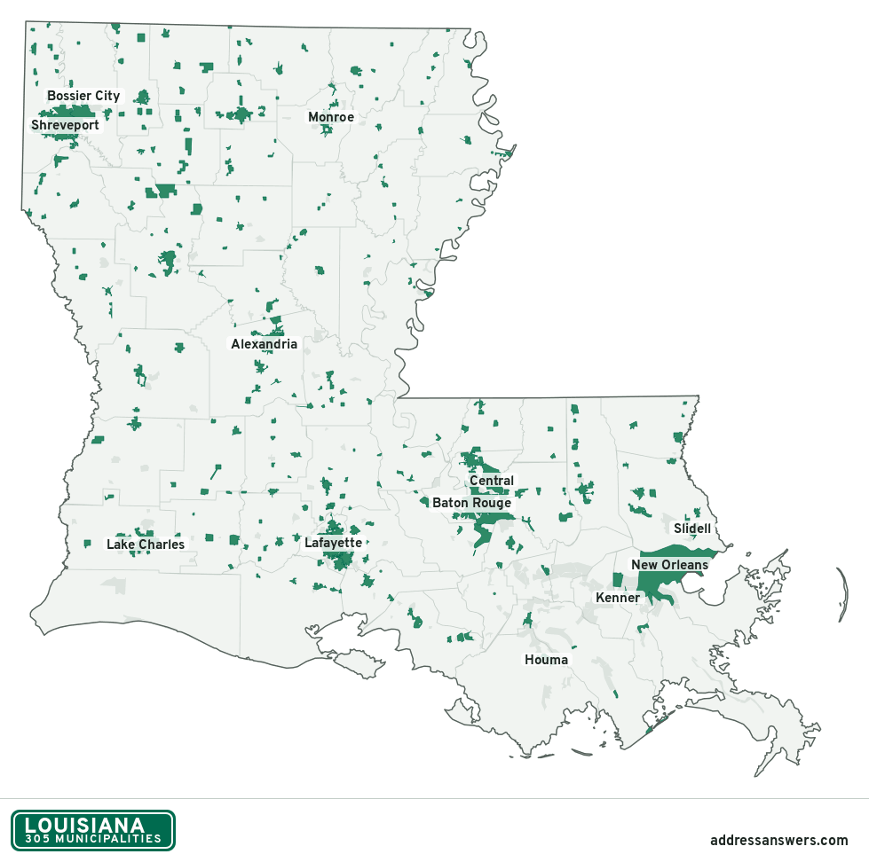
Louisiana city limits map image
The map above as a picture: every Louisiana municipality in green, with county lines. Boundaries from the Census Bureau, as of January 1, 2025.
You’re welcome to use it in a document or on your own site, with a link back to this page.
Download the map (PNG, 979 × 972)Questions about Louisiana city limits
How many municipalities are in Louisiana?
Louisiana has 305 incorporated places: 70 cities, 128 towns, and 107 villages, by the Census Bureau’s boundary files for 2025.
What is the largest city in Louisiana?
By population, New Orleans, with about 371,853 residents (2020–2024 American Community Survey 5-year estimates). It is also the largest by land area, at 169.6 square miles.
What is the smallest village in Louisiana?
By the Census Bureau’s estimate, Powhatan, with 35 residents. Estimates for places this small have a wide margin of error, so treat it as a rough count.
How much of Louisiana is unincorporated?
96% of its land and 2.5 million of its residents (54%) are outside every municipality. There, local government is the parish. The state also has 179 named unincorporated communities; the largest is Metairie.
Is Metairie, LA a city?
No. Metairie is a census-designated place: a community the Census Bureau maps for statistics, with no city government of its own. About 139,729 people live there, in unincorporated Jefferson Parish. An address there is outside city limits, even if its mailing address says otherwise.
Is Prairieville, LA a city?
No. Prairieville is a census-designated place: a community the Census Bureau maps for statistics, with no city government of its own. About 35,238 people live there, in unincorporated Ascension Parish. An address there is outside city limits, even if its mailing address says otherwise.
Which municipalities in Louisiana are in more than one parish?
Ten of the 305 cross a parish line, by at least 1% of their land. The largest: Shreveport (Caddo and Bossier), Broussard (Lafayette and St. Martin), and Morgan City (St. Mary and St. Martin). Check an address to see which parish it’s in.
Which parish in Louisiana has the most municipalities?
St. Landry Parish, with 12 at least partly inside it. Five parishes have none.
Bordering states
More answers for a Louisiana address
Each tool checks the same address and puts its own answer first.
- County Census Your county, plus the township or town where those exist. Find your county
- School district Census The public school district that covers the address. Find your school district
- Flood zone FEMA The FEMA zone in plain English, and whether lenders require flood insurance. Check flood zone
- USDA home loans USDA Whether the property is in an area eligible for a USDA Rural Development loan. Check USDA eligibility
- Voting districts Census Your congressional district and your state senate and state house districts. Included in every check
Places, boundaries, land area and parishes: US Census Bureau 2025 cartographic boundary files (boundaries as of January 1, 2025). A place is listed in each parish that holds at least 1% of its land. Population: 2020–2024 American Community Survey 5-year estimates. Data updated October 24, 2026; page updated October 25, 2026. Boundaries change through annexation; your city or parish has the official map.