New Mexico city limits map
New Mexico has 105 incorporated places: 37 cities, 48 villages, and 20 towns. They cover 1% of the state’s land and are home to 68% of its residents. Everyone else lives outside city limits, where local government is the county. Enter an address to see which side of a city line it’s on.
Result for
The map couldn’t load. The answers don’t depend on it.
The boundary couldn’t load. The answer doesn’t depend on it.
Census Geocoder match
More about this address
Sources and limits
- Census
- US Census Bureau Geocoder, current boundaries
- FEMA
- National Flood Hazard Layer, effective flood maps
- USDA
- Rural Development property eligibility
- Map
- Boundaries from Census TIGERweb, flood zones drawn by FEMA, eligible areas from USDA, base map © OpenStreetMap contributors
Census boundaries are updated once a year, so a recent annexation may not show yet. Informational only, not an official determination. Verify with your city or county.
New Mexico at a glance
- Incorporated places
- 105
- 37 cities, 48 villages, and 20 towns
- Residents in city limits
- 68%
- 1,432,765 of 2,120,246
- Land in city limits
- 1%
- 1,182 of 121,313 sq mi
- Counties
- 33
- 1 with no municipality
- Unincorporated communities
- 423
- Largest: South Valley (37,120)
- Largest city
- Albuquerque
- 562,218 residents
City limits maps for 3 New Mexico cities
Every New Mexico city with 100,000 or more residents has its own page: the boundary in detail, the places around it and its school districts.
All 105 municipalities in New Mexico
Every incorporated place, largest first, with the counties it’s in and its size. An address inside one of these is inside city limits; anywhere else in the state is unincorporated.
| Name | Type | County | Population | Land (sq mi) |
|---|---|---|---|---|
| Albuquerque | City | Bernalillo | 562,218 | 187.3 |
| Las Cruces | City | Doña Ana | 114,197 | 76.9 |
| Rio Rancho | City | Sandoval, Bernalillo | 108,515 | 103.4 |
| Santa Fe | City | Santa Fe | 89,019 | 52.2 |
| Roswell | City | Chaves | 47,638 | 29.7 |
| Farmington | City | San Juan | 46,314 | 34.5 |
| Hobbs | City | Lea | 40,252 | 26.4 |
| Clovis | City | Curry | 37,942 | 23.6 |
| Carlsbad | City | Eddy | 31,746 | 31.7 |
| Alamogordo | City | Otero | 31,307 | 21.6 |
| Gallup | City | McKinley | 21,023 | 20.2 |
| Los Lunas | Village | Valencia | 18,618 | 20.5 |
| Sunland Park | City | Doña Ana | 17,463 | 14.7 |
| Deming | City | Luna | 15,221 | 16.7 |
| Las Vegas | City | San Miguel | 13,000 | 8.62 |
| Artesia | City | Eddy | 12,576 | 11.4 |
| Portales | City | Roosevelt | 11,968 | 8.03 |
| Lovington | City | Lea | 11,498 | 11.2 |
| Española | City | Rio Arriba, Santa Fe | 10,473 | 8.22 |
| Silver City | Town | Grant | 9,536 | 10.1 |
| Bernalillo | Town | Sandoval | 9,086 | 5.22 |
| Grants | City | Cibola | 8,951 | 14.9 |
| Anthony | City | Doña Ana | 8,767 | 2.70 |
| Corrales | Village | Sandoval | 8,555 | 10.8 |
| Socorro | City | Socorro | 8,481 | 14.5 |
| Ruidoso | Village | Lincoln | 7,699 | 16.1 |
| Belen | City | Valencia | 7,450 | 19.1 |
| Bloomfield | City | San Juan | 7,395 | 18.5 |
| Taos | Town | Taos | 6,458 | 6.16 |
| Aztec | City | San Juan | 6,150 | 17.1 |
| Edgewood | Town | Santa Fe, Bernalillo +1 | 6,124 | 56.8 |
| Raton | City | Colfax | 6,026 | 7.96 |
| Truth or Consequences | City | Sierra | 6,019 | 28.0 |
| Los Ranchos de Albuquerque | Village | Bernalillo | 5,857 | 4.45 |
| Tucumcari | City | Quay | 5,160 | 9.51 |
| Rio Communities | City | Valencia | 4,925 | 7.69 |
| Bosque Farms | Village | Valencia | 4,071 | 3.93 |
| Peralta | Town | Valencia | 3,404 | 4.45 |
| Eunice | City | Lea | 3,015 | 4.09 |
| Clayton | Town | Union | 2,753 | 7.62 |
| Ruidoso Downs | City | Lincoln | 2,655 | 3.79 |
| Tularosa | Village | Otero | 2,597 | 2.82 |
| Questa | Village | Taos | 2,466 | 7.08 |
| Santa Rosa | City | Guadalupe | 2,462 | 5.00 |
| Jal | City | Lea | 2,364 | 4.82 |
| Milan | Village | Cibola | 2,327 | 4.41 |
| Moriarty | City | Torrance | 2,102 | 6.93 |
| Bayard | City | Grant | 2,057 | 0.95 |
| Lordsburg | City | Hidalgo | 2,057 | 8.42 |
| Santa Clara | Village | Grant | 1,809 | 1.99 |
| Elephant Butte | City | Sierra | 1,790 | 4.18 |
| Mesilla | Town | Doña Ana | 1,717 | 5.68 |
| Hatch | Village | Doña Ana | 1,588 | 3.00 |
| Estancia | Town | Torrance | 1,432 | 6.17 |
| Loving | Village | Eddy | 1,357 | 1.21 |
| Pecos | Village | San Miguel | 1,204 | 1.78 |
| Columbus | Village | Luna | 1,196 | 4.67 |
| Capitan | Village | Lincoln | 1,191 | 3.26 |
| Mountainair | Town | Torrance | 1,178 | 1.58 |
| Dexter | Town | Chaves | 1,128 | 0.73 |
| Angel Fire | Village | Colfax | 1,111 | 28.4 |
| Hurley | Town | Grant | 1,044 | 1.02 |
| Springer | Town | Colfax | 1,017 | 2.20 |
| Magdalena | Village | Socorro | 976 | 6.22 |
| Texico | City | Curry | 967 | 0.83 |
| Fort Sumner | Village | De Baca | 938 | 3.31 |
| Carrizozo | Town | Lincoln | 854 | 8.36 |
| Hagerman | Town | Chaves | 849 | 1.36 |
| Chama | Village | Rio Arriba | 776 | 2.88 |
| Logan | Village | Quay | 740 | 10.6 |
| Cimarron | Village | Colfax | 701 | 2.12 |
| Cloudcroft | Village | Otero | 630 | 1.64 |
| Tatum | Town | Lea | 598 | 1.59 |
| Wagon Mound | Village | Mora | 557 | 1.01 |
| Tijeras | Village | Bernalillo | 524 | 1.15 |
| Vaughn | Town | Guadalupe | 493 | 5.60 |
| Lake Arthur | Town | Chaves | 478 | 0.53 |
| Williamsburg | Village | Sierra | 466 | 0.49 |
| Kirtland | Town | San Juan | 465 | 1.72 |
| Cuba | Village | Sandoval | 462 | 3.26 |
| Eagle Nest | Village | Colfax | 451 | 4.48 |
| Red River | Town | Taos | 450 | 1.02 |
| Melrose | Village | Curry | 447 | 1.69 |
| Reserve | Village | Catron | 402 | 0.56 |
| Maxwell | Village | Colfax | 331 | 0.47 |
| Roy | Village | Harding | 302 | 2.04 |
| Jemez Springs | Village | Sandoval | 284 | 4.80 |
| Willard | Village | Torrance | 248 | 0.92 |
| Virden | Village | Hidalgo | 175 | 0.21 |
| Des Moines | Village | Union | 174 | 0.87 |
| Corona | Village | Lincoln | 168 | 1.03 |
| Elida | Town | Roosevelt | 165 | 1.02 |
| San Ysidro | Village | Sandoval | 146 | 2.34 |
| Floyd | Village | Roosevelt | 134 | 3.08 |
| Causey | Village | Roosevelt | 122 | 3.75 |
| San Jon | Village | Quay | 102 | 2.93 |
| Grady | Village | Curry | 99 | 0.27 |
| House | Village | Quay | 91 | 0.91 |
| Taos Ski Valley | Village | Taos | 65 | 2.85 |
| Grenville | Village | Union | 56 | 0.38 |
| Hope | Village | Eddy | 49 | 1.12 |
| Dora | Village | Roosevelt | 44 | 2.59 |
| Encino | Village | Torrance | 31 | 1.99 |
| Mosquero | Village | Harding, San Miguel | 25 | 1.00 |
| Folsom | Village | Union | 11 | 0.65 |
Showing 1–50 of 105
Unincorporated communities in New Mexico
Census-designated places: named communities the Census Bureau maps for statistics, with no city government of their own. An address in one is outside city limits, even when its mailing address names a city. New Mexico has 423.
| Community | County | Population | Land (sq mi) |
|---|---|---|---|
| South Valley | Bernalillo | 37,120 | 29.0 |
| Chaparral | Doña Ana | 18,186 | 59.1 |
| Los Alamos | Los Alamos | 13,317 | 11.1 |
| North Valley | Bernalillo | 10,455 | 6.95 |
| Shiprock | San Juan | 7,610 | 13.5 |
| Santa Teresa | Doña Ana | 6,041 | 8.85 |
| North Hobbs | Lea | 6,034 | 26.0 |
| Zuni Pueblo | McKinley | 5,864 | 12.6 |
| White Rock | Los Alamos | 5,716 | 7.07 |
| Eldorado at Santa Fe | Santa Fe | 5,619 | 20.8 |
| El Cerro Mission | Valencia | 5,323 | 5.88 |
| Los Chaves | Valencia | 4,838 | 11.4 |
| Crouch Mesa | San Juan | 4,812 | 20.7 |
| Paradise Hills | Bernalillo | 4,591 | 1.02 |
| Holloman AFB | Otero | 4,433 | 12.6 |
| Lee Acres | San Juan | 4,272 | 10.3 |
| Meadow Lake | Valencia | 4,259 | 11.6 |
| Placitas | Sandoval | 4,223 | 29.4 |
| La Cienega | Santa Fe | 3,543 | 11.7 |
| Kirtland AFB | Bernalillo | 3,413 | 5.45 |
| Dulce | Rio Arriba | 3,218 | 12.8 |
| Sandia Heights | Bernalillo | 3,160 | 1.85 |
| El Cerro | Valencia | 2,923 | 4.23 |
| Agua Fria | Santa Fe | 2,898 | 2.42 |
| Vado | Doña Ana | 2,895 | 2.98 |
| Crownpoint | McKinley | 2,882 | 67.1 |
| University Park | Doña Ana | 2,782 | 1.53 |
| Flora Vista | San Juan | 2,770 | 4.95 |
| La Mesilla | Rio Arriba | 2,697 | 4.45 |
| Ranchos de Taos | Taos | 2,536 | 3.53 |
| Valencia | Valencia | 2,406 | 1.98 |
| Cannon AFB | Curry | 2,405 | 5.86 |
| Chimayo | Santa Fe | 2,390 | 7.74 |
| Santo Domingo Pueblo | Sandoval | 2,370 | 2.04 |
| Pojoaque | Santa Fe | 2,327 | 4.37 |
| Center Point | San Juan | 2,286 | 9.19 |
| West Hammond | San Juan | 2,236 | 9.11 |
| La Plata | San Juan | 2,233 | 22.2 |
| Jemez Pueblo | Sandoval | 2,199 | 2.04 |
| Navajo | McKinley | 2,181 | 2.25 |
| Jarales | Valencia | 2,144 | 8.71 |
| Las Campanas | Santa Fe | 2,119 | 10.4 |
| San Ysidro | Doña Ana | 2,118 | 2.65 |
| Arroyo Seco | Taos | 2,112 | 6.83 |
| Nambe | Santa Fe | 2,035 | 8.69 |
| Picacho Hills | Doña Ana | 2,002 | 3.24 |
| Angustura | San Juan | 1,997 | 4.77 |
| Thoreau | McKinley | 1,973 | 39.5 |
| McIntosh | Torrance | 1,943 | 23.3 |
| Tres Arroyos | Santa Fe | 1,926 | 9.23 |
| Radium Springs | Doña Ana | 1,908 | 5.97 |
| Boles Acres | Otero | 1,848 | 12.2 |
| South River | San Juan | 1,810 | 8.53 |
| La Luz | Otero | 1,797 | 10.7 |
| Tome | Valencia | 1,723 | 5.52 |
| Dixon | Rio Arriba | 1,623 | 11.5 |
| White Sands | Doña Ana | 1,609 | 4.22 |
| Las Maravillas | Valencia | 1,594 | 1.01 |
| Tano Road | Santa Fe | 1,586 | 11.5 |
| Rio Rancho Estates | Sandoval | 1,571 | 68.4 |
| La Villita | Rio Arriba | 1,534 | 1.36 |
| Cuartelez | Santa Fe | 1,512 | 1.37 |
| Algodones | Sandoval | 1,479 | 7.31 |
| Upper Fruitland | San Juan | 1,457 | 7.65 |
| Berino | Doña Ana | 1,454 | 0.94 |
| El Rancho | Santa Fe | 1,451 | 2.10 |
| Little Walnut Village | Grant | 1,445 | 5.86 |
| Sandia Knolls | Bernalillo | 1,445 | 2.80 |
| Ponderosa Pine | Bernalillo | 1,442 | 8.02 |
| Church Rock | McKinley | 1,381 | 18.4 |
| Keeler Farm | Luna | 1,376 | 11.4 |
| Thunder Mountain | Santa Fe | 1,366 | 4.42 |
| Atoka | Eddy | 1,347 | 6.76 |
| Paraje | Cibola | 1,333 | 5.57 |
| High Rolls | Otero | 1,313 | 15.4 |
| Barton | Bernalillo | 1,302 | 9.16 |
| El Valle de Arroyo Seco | Santa Fe | 1,293 | 5.13 |
| La Huerta | Eddy | 1,288 | 1.52 |
| Spencerville | San Juan | 1,264 | 5.25 |
| Cañoncito | Santa Fe | 1,253 | 9.91 |
| Arenas Valley | Grant | 1,247 | 4.07 |
| Iyanbito | McKinley | 1,233 | 9.54 |
| Skyline-Ganipa | Cibola | 1,226 | 7.82 |
| Ohkay Owingeh | Rio Arriba | 1,194 | 3.84 |
| Gamerco | McKinley | 1,176 | 0.96 |
| Waterflow | San Juan | 1,140 | 8.25 |
| Los Luceros | Rio Arriba | 1,136 | 1.64 |
| Taos Pueblo | Taos | 1,129 | 15.6 |
| Black Rock | McKinley | 1,125 | 1.75 |
| Butterfield Park | Doña Ana | 1,119 | 0.45 |
| San Felipe Pueblo | Sandoval | 1,119 | 12.0 |
| El Rito | Rio Arriba | 1,102 | 4.11 |
| Tesuque | Santa Fe | 1,079 | 5.66 |
| La Union | Doña Ana | 1,071 | 4.14 |
| Isleta | Bernalillo | 1,043 | 0.73 |
| San Rafael | Cibola | 1,039 | 15.8 |
| Polvadera | Socorro | 1,033 | 0.97 |
| Prewitt | McKinley | 1,027 | 13.8 |
| Santa Ana Pueblo | Sandoval | 1,026 | 7.40 |
| Rock Springs | McKinley | 1,013 | 12.6 |
| Las Tusas | Cibola | 999 | 2.98 |
| Talpa | Taos | 955 | 1.31 |
| Salem | Doña Ana | 916 | 1.31 |
| Cedar Hill | San Juan | 902 | 9.40 |
| Cedar Grove | Santa Fe | 901 | 12.8 |
| Sunlit Hills | Santa Fe | 899 | 3.75 |
| Twin Lakes | McKinley | 893 | 9.01 |
| Cedar Crest | Bernalillo | 886 | 3.13 |
| Carnuel | Bernalillo | 877 | 5.32 |
| Doña Ana | Doña Ana | 868 | 0.64 |
| Chamita | Rio Arriba | 867 | 3.85 |
| Happy Valley | Eddy | 845 | 2.14 |
| Mescalero | Otero | 832 | 17.9 |
| Tyrone | Grant | 814 | 0.34 |
| Santa Fe Foothills | Santa Fe | 779 | 8.28 |
| La Cueva | Santa Fe | 778 | 7.68 |
| San Jose | Rio Arriba | 776 | 1.81 |
| San Miguel | Doña Ana | 772 | 2.29 |
| Zia Pueblo | Sandoval | 770 | 27.0 |
| Hernandez | Rio Arriba | 769 | 1.70 |
| Tohatchi | McKinley | 750 | 6.47 |
| Paa-Ko | Bernalillo | 743 | 5.80 |
| San Ildefonso Pueblo | Santa Fe | 737 | 4.42 |
| Santa Clara Pueblo | Rio Arriba | 733 | 2.02 |
| Valle Vista | Santa Fe | 729 | 0.27 |
| Fort Wingate | McKinley | 726 | 2.02 |
| McCartys Village | Cibola | 723 | 3.21 |
| Napi Headquarters | San Juan | 717 | 4.45 |
| La Puebla | Santa Fe | 715 | 2.84 |
| San Pablo | Doña Ana | 696 | 1.22 |
| San Antonito | Bernalillo | 688 | 2.44 |
| Adelino | Valencia | 686 | 2.98 |
| Cochiti | Sandoval | 680 | 0.78 |
| Mesquite | Doña Ana | 675 | 0.82 |
| Monterey Park | Valencia | 667 | 2.64 |
| Pinehill | Cibola | 664 | 3.53 |
| East Pecos | San Miguel | 643 | 3.60 |
| Williams Acres | McKinley | 643 | 0.80 |
| La Hacienda | Luna | 640 | 1.35 |
| Indian Hills | Torrance | 622 | 5.71 |
| Fairacres | Doña Ana | 616 | 2.11 |
| Ventura | Luna | 603 | 5.46 |
| San Mateo | Cibola | 602 | 2.77 |
| Sausal | Valencia | 602 | 2.24 |
| Pueblitos | Valencia | 595 | 2.13 |
| Acomita Lake | Cibola | 590 | 3.89 |
| Sundance | McKinley | 585 | 3.47 |
| White Cliffs | McKinley | 581 | 0.43 |
| Chamberino | Doña Ana | 580 | 3.06 |
| Crestview | McKinley | 580 | 1.30 |
| Torreon | Sandoval | 580 | 13.9 |
| North Light Plant | San Juan | 579 | 2.16 |
| Pecan Park | Luna | 575 | 0.11 |
| Pinedale | McKinley | 575 | 10.3 |
| Fruitland | San Juan | 574 | 1.96 |
| Peña Blanca | Sandoval | 568 | 6.89 |
| Sedillo | Bernalillo | 565 | 2.75 |
| Conejo | Santa Fe | 555 | 1.90 |
| Peñasco | Taos | 546 | 1.22 |
| Midway | Chaves | 541 | 2.49 |
| Seama | Cibola | 538 | 6.49 |
| La Madera | Sandoval | 532 | 13.1 |
| Truchas | Rio Arriba | 528 | 6.93 |
| Sunshine | Luna | 524 | 17.6 |
| Mora | Mora | 520 | 8.03 |
| Seboyeta | Cibola | 517 | 2.67 |
| Placitas | Doña Ana | 516 | 0.13 |
| Rowe | San Miguel | 516 | 6.11 |
| Mesita | Cibola | 514 | 7.47 |
| Cuyamungue | Santa Fe | 509 | 1.17 |
| Yah-ta-hey | McKinley | 507 | 3.44 |
| Blanco | San Juan | 492 | 6.14 |
| Lobo Canyon | Cibola | 492 | 4.30 |
| Arrey | Sierra | 491 | 0.79 |
| Rio Lucio | Taos | 485 | 1.05 |
| Timberon | Otero | 479 | 20.3 |
| Cochiti Lake | Sandoval | 476 | 1.24 |
| La Mesa | Doña Ana | 473 | 2.37 |
| Ojo Encino | McKinley | 470 | 0.65 |
| Tecolotito | San Miguel | 465 | 0.72 |
| Sullivan | San Juan | 463 | 9.82 |
| Livingston Wheeler | Eddy | 460 | 1.65 |
| Laguna | Cibola | 459 | 9.55 |
| El Duende | Rio Arriba | 454 | 1.47 |
| Canova | Rio Arriba | 452 | 0.85 |
| Costilla | Taos | 450 | 3.03 |
| Jamestown | McKinley | 439 | 2.73 |
| Cañon | Sandoval | 436 | 16.1 |
| Monument | Lea | 432 | 5.28 |
| Tierra Amarilla | Rio Arriba | 429 | 2.69 |
| Peak Place | Santa Fe | 427 | 1.31 |
| Pueblo of Sandia Village | Sandoval | 416 | 1.13 |
| Newcomb | San Juan | 415 | 9.68 |
| Jacona | Santa Fe | 412 | 0.85 |
| Ojo Amarillo | San Juan | 411 | 1.96 |
| Ramah | McKinley | 407 | 12.3 |
| Nenahnezad | San Juan | 406 | 3.45 |
| Highland Meadows | Valencia | 405 | 6.93 |
| Cordova | Rio Arriba | 389 | 1.66 |
| Glorieta | Santa Fe | 385 | 7.65 |
| Tortugas | Doña Ana | 381 | 0.20 |
| Puerto de Luna | Guadalupe | 378 | 14.2 |
| Cuyamungue Grant | Santa Fe | 376 | 2.55 |
| Cedro | Bernalillo | 372 | 5.39 |
| Brimhall Nizhoni | McKinley | 367 | 16.3 |
| Gila | Grant | 366 | 9.36 |
| Naschitti | San Juan | 361 | 2.51 |
| Sheep Springs | San Juan | 360 | 5.13 |
| Casa Colorada | Valencia | 351 | 5.52 |
| Mount Taylor | Cibola | 335 | 1.91 |
| Chupadero | Santa Fe | 334 | 1.81 |
| Sandia Park | Bernalillo | 333 | 0.72 |
| Mimbres | Grant | 330 | 3.49 |
| Nageezi | San Juan | 327 | 14.1 |
| Tesuque Pueblo | Santa Fe | 325 | 2.20 |
| Gallina | Rio Arriba | 318 | 6.29 |
| Lemitar | Socorro | 316 | 1.37 |
| Cañada de los Alamos | Santa Fe | 315 | 3.68 |
| La Tierra | Santa Fe | 315 | 9.81 |
| Twin Forks | Otero | 310 | 4.13 |
| Malaga | Eddy | 309 | 2.97 |
| Las Palomas | Sierra | 304 | 1.60 |
| Catalpa Canyon | McKinley | 302 | 7.04 |
| Chamisal | Taos | 300 | 1.64 |
| Broadview | Cibola | 296 | 3.75 |
| Madrone | Valencia | 295 | 3.08 |
| Lamy | Santa Fe | 294 | 2.59 |
| South Acomita Village | Cibola | 294 | 1.19 |
| Madrid | Santa Fe | 292 | 1.39 |
| Ponderosa | Sandoval | 289 | 9.13 |
| Crystal | San Juan | 287 | 4.55 |
| Cotton City | Hidalgo | 286 | 25.8 |
| Alcalde | Rio Arriba | 285 | 0.52 |
| Villanueva | San Miguel | 283 | 7.26 |
| Conchas Dam | San Miguel | 282 | 8.33 |
| North Acomita Village | Cibola | 282 | 3.85 |
| Medanales | Rio Arriba | 280 | 3.16 |
| Anton Chico | Guadalupe | 276 | 1.79 |
| Bluewater | McKinley | 275 | 12.3 |
| Nadine | Lea | 271 | 11.4 |
| Rincon | Doña Ana | 271 | 1.05 |
| Navajo Dam | San Juan | 269 | 12.1 |
| Jaconita | Santa Fe | 268 | 0.67 |
| Vadito | Taos | 264 | 0.86 |
| Hanover | Grant | 263 | 1.40 |
| Pleasanton | Catron | 259 | 1.52 |
| Rancho Grande | Catron | 254 | 0.42 |
| Rosedale | Grant | 252 | 1.77 |
| Nakaibito | McKinley | 251 | 7.00 |
| Haystack | McKinley | 250 | 4.26 |
| Alamillo | Socorro | 247 | 1.20 |
| Glen Acres | Hidalgo | 247 | 0.99 |
| Alamo | Socorro | 246 | 39.2 |
| Sacramento | Otero | 246 | 6.55 |
| Los Cerrillos | Santa Fe | 241 | 3.37 |
| Becenti | McKinley | 235 | 0.94 |
| Totah Vista | San Juan | 235 | 0.57 |
| Caballo | Sierra | 233 | 0.98 |
| Continental Divide | McKinley | 231 | 2.76 |
| Galisteo | Santa Fe | 231 | 3.37 |
| Velarde | Rio Arriba | 229 | 2.55 |
| Santa Cruz | Santa Fe | 228 | 0.62 |
| Paguate | Cibola | 226 | 4.87 |
| Ensenada | Rio Arriba | 225 | 1.46 |
| Pulpotio Bareas | Luna | 221 | 0.52 |
| San Lorenzo | Grant | 219 | 1.75 |
| Sanostee | San Juan | 214 | 4.54 |
| Beclabito | San Juan | 212 | 7.53 |
| North San Ysidro | San Miguel | 210 | 2.30 |
| Chili | Rio Arriba | 209 | 3.28 |
| San Cristobal | Taos | 203 | 6.89 |
| Middle Mesa | San Juan | 198 | 6.71 |
| Sagar | McKinley | 197 | 1.87 |
| Casas Adobes | Grant | 195 | 0.93 |
| Hyde Park | Santa Fe | 189 | 2.12 |
| Pueblo Pintado | McKinley | 187 | 31.0 |
| Rio Chiquito | Santa Fe | 187 | 1.08 |
| Animas | Hidalgo | 186 | 15.7 |
| Anzac Village | Cibola | 185 | 0.98 |
| Canjilon | Rio Arriba | 185 | 3.21 |
| Edith Enclave | Bernalillo | 185 | 1.51 |
| Stanley | Santa Fe | 185 | 6.17 |
| Candy Kitchen | Cibola | 180 | 13.0 |
| White Signal | Grant | 177 | 6.43 |
| La Jara | Sandoval | 176 | 14.3 |
| San Acacia | Socorro | 176 | 0.70 |
| Encantado | Santa Fe | 175 | 2.68 |
| San Pedro | Santa Fe | 172 | 9.76 |
| La Madera | Rio Arriba | 171 | 4.44 |
| Sombrillo | Santa Fe | 168 | 0.95 |
| North Hurley | Grant | 166 | 1.53 |
| La Cueva | Sandoval | 162 | 1.65 |
| Ribera | San Miguel | 162 | 2.52 |
| Glenwood | Catron | 160 | 1.54 |
| La Joya | Socorro | 159 | 0.94 |
| Veguita | Socorro | 157 | 0.84 |
| Sena | San Miguel | 155 | 2.13 |
| Organ | Doña Ana | 152 | 0.86 |
| Nara Visa | Quay | 151 | 7.05 |
| Hillsboro | Sierra | 150 | 2.13 |
| Pie Town | Catron | 147 | 57.3 |
| San Antonito | Socorro | 142 | 1.73 |
| Chical | Valencia | 141 | 0.81 |
| Arroyo Hondo | Santa Fe | 135 | 3.17 |
| Bluewater Village | Cibola | 133 | 7.54 |
| Purty Rock | McKinley | 133 | 1.16 |
| Lumberton | Rio Arriba | 130 | 0.48 |
| Tajique | Torrance | 130 | 2.70 |
| Borrego Pass | McKinley | 129 | 13.2 |
| Tecolote | San Miguel | 126 | 5.63 |
| Torreon | Torrance | 125 | 8.28 |
| Turley | San Juan | 117 | 4.63 |
| Pinos Altos | Grant | 113 | 0.76 |
| Ojo Sarco | Rio Arriba | 112 | 3.41 |
| Lindrith | Rio Arriba | 111 | 3.64 |
| Hot Springs Landing | Sierra | 110 | 0.45 |
| Timberlake | McKinley | 110 | 16.0 |
| Llano del Medio | Guadalupe | 109 | 1.91 |
| Cliff | Grant | 106 | 10.3 |
| Morningside | Eddy | 103 | 0.09 |
| Seton Village | Santa Fe | 101 | 0.15 |
| Quemado | Catron | 100 | 1.79 |
| Tse Bonito | McKinley | 93 | 6.81 |
| San Antonio | Socorro | 89 | 0.45 |
| San Jose | San Miguel | 87 | 0.26 |
| Lake Sumner | De Baca | 86 | 62.3 |
| Pueblo | San Miguel | 86 | 1.82 |
| Garfield | Doña Ana | 85 | 0.78 |
| Lake Valley | San Juan | 83 | 8.35 |
| Pajarito Mesa | Bernalillo | 83 | 21.3 |
| Nogal | Lincoln | 80 | 7.61 |
| Capulin | Union | 79 | 1.48 |
| San Fidel | Cibola | 79 | 4.21 |
| La Boca | San Juan | 78 | 0.56 |
| Buckhorn | Grant | 76 | 4.64 |
| Oasis | Sierra | 75 | 2.09 |
| Arroyo Hondo | Taos | 74 | 1.65 |
| Loco Hills | Eddy | 72 | 0.86 |
| Luna | Catron | 72 | 5.56 |
| Middle Frisco | Catron | 70 | 0.55 |
| Rio en Medio | Santa Fe | 69 | 0.66 |
| Aragon | Catron | 65 | 8.45 |
| Coyote | Rio Arriba | 64 | 4.15 |
| Las Nutrias | Socorro | 64 | 0.97 |
| Golden Acres | Cibola | 62 | 0.92 |
| Vanderwagen | McKinley | 61 | 1.99 |
| Soham | San Miguel | 60 | 1.55 |
| Windmill | Hidalgo | 58 | 1.45 |
| Cañones | Rio Arriba | 57 | 4.14 |
| El Morro Valley | Cibola | 53 | 13.3 |
| Luis Lopez | Socorro | 53 | 0.54 |
| Alma | Catron | 52 | 3.25 |
| Picuris Pueblo | Taos | 50 | 0.46 |
| Escudilla Bonita | Catron | 48 | 12.2 |
| Mountain View | Cibola | 48 | 2.07 |
| Rivers | Catron | 48 | 2.24 |
| Chilili | Bernalillo | 46 | 0.99 |
| Punta de Agua | Torrance | 46 | 1.38 |
| Youngsville | Rio Arriba | 44 | 0.89 |
| Valencia | Santa Fe | 42 | 1.55 |
| Watrous | Mora | 42 | 0.57 |
| Pueblito | Rio Arriba | 41 | 0.61 |
| Abiquiu | Rio Arriba | 40 | 0.95 |
| Mayhill | Otero | 38 | 9.50 |
| Chamizal | Socorro | 35 | 0.44 |
| Newkirk | Guadalupe | 32 | 1.09 |
| Regina | Sandoval | 31 | 7.27 |
| Deer Canyon | Torrance | 29 | 8.00 |
| Manuelito | McKinley | 27 | 8.16 |
| Los Ojos | Rio Arriba | 23 | 1.39 |
| Apache Creek | Catron | 22 | 8.20 |
| Cruzville | Catron | 22 | 2.55 |
| Lybrook | Rio Arriba | 21 | 3.88 |
| Golden | Santa Fe | 20 | 6.73 |
| Trout Valley | Grant | 19 | 0.18 |
| Cundiyo | Santa Fe | 18 | 0.95 |
| Rodeo | Hidalgo | 18 | 8.19 |
| Datil | Catron | 17 | 1.87 |
| Playas | Hidalgo | 16 | 1.86 |
| Hachita | Grant | 14 | 0.44 |
| La Bajada | Santa Fe | 11 | 0.17 |
| Bent | Otero | 10 | 6.14 |
| Gila Hot Springs | Grant | 10 | 1.65 |
| Orogrande | Otero | 9 | 5.68 |
| Mogollon | Catron | 8 | 1.79 |
| Pinehaven | McKinley | 8 | 6.97 |
| Manzano Springs | Torrance | 7 | 2.28 |
| Black Hat | McKinley | 2 | 1.04 |
| Homer C Jones | McKinley | 2 | 0.25 |
| Pastura | Guadalupe | 2 | 0.35 |
| Abeytas | Socorro | 0 | 1.23 |
| Bibo | Cibola | 0 | 4.19 |
| Brazos | Rio Arriba | 0 | 0.22 |
| City of the Sun | Luna | 0 | 0.25 |
| Cobre | Grant | 0 | 0.07 |
| Cubero | Cibola | 0 | 9.57 |
| Duran | Torrance | 0 | 4.69 |
| Encinal | Cibola | 0 | 2.97 |
| Escondida | Socorro | 0 | 0.13 |
| Faywood | Grant | 0 | 0.53 |
| Fence Lake | Cibola | 0 | 3.00 |
| Homestead | Catron | 0 | 1.17 |
| Kingston | Sierra | 0 | 0.20 |
| Lake Roberts | Grant | 0 | 0.28 |
| Lake Roberts Heights | Grant | 0 | 0.76 |
| Lower Frisco | Catron | 0 | 1.01 |
| Lyden | Rio Arriba | 0 | 2.24 |
| Manzano | Torrance | 0 | 1.69 |
| McGaffey | McKinley | 0 | 1.75 |
| Moquino | Cibola | 0 | 0.70 |
| Mountain View | Luna | 0 | 0.30 |
| Ojo Caliente | Taos | 0 | 2.65 |
| Old Town | Luna | 0 | 12.7 |
| Pinon | Otero | 0 | 5.16 |
| Red Rock Ranch | McKinley | 0 | 4.77 |
| Redrock | Grant | 0 | 0.60 |
| Rodey | Doña Ana | 0 | 0.56 |
| San Luis | Sandoval | 0 | 8.28 |
| Stoneridge | Cibola | 0 | 0.80 |
| Ute Park | Colfax | 0 | 3.40 |
| Weed | Otero | 0 | 8.97 |
| Whites City | Eddy | 0 | 0.43 |
| Winston | Sierra | 0 | 0.42 |
Showing 1–50 of 423
Counties in New Mexico
33 counties, with how many municipalities have land in each and the largest whose main county it is.
| County | Municipalities | Largest | Population | Land (sq mi) |
|---|---|---|---|---|
| Bernalillo County | 5 | Albuquerque | 673,930 | 1,161 |
| Doña Ana County | 5 | Las Cruces | 224,266 | 3,808 |
| Santa Fe County | 3 | Santa Fe | 156,105 | 1,910 |
| Sandoval County | 7 | Rio Rancho | 153,604 | 3,710 |
| San Juan County | 4 | Farmington | 120,942 | 5,517 |
| Valencia County | 5 | Los Lunas | 78,458 | 1,067 |
| Lea County | 5 | Hobbs | 73,733 | 4,392 |
| McKinley County | 1 | Gallup | 70,431 | 5,451 |
| Otero County | 3 | Alamogordo | 68,816 | 6,613 |
| Chaves County | 4 | Roswell | 64,217 | 6,067 |
| Eddy County | 4 | Carlsbad | 61,105 | 4,176 |
| Curry County | 4 | Clovis | 47,638 | 1,406 |
| Rio Arriba County | 2 | Española | 40,070 | 5,861 |
| Taos County | 4 | Taos | 34,543 | 2,202 |
| Grant County | 4 | Silver City | 27,775 | 3,961 |
| San Miguel County | 3 | Las Vegas | 26,850 | 4,722 |
| Cibola County | 2 | Grants | 26,845 | 4,540 |
| Luna County | 2 | Deming | 25,611 | 2,965 |
| Lincoln County | 5 | Ruidoso | 20,224 | 4,831 |
| Los Alamos County | 0 | None | 19,435 | 109.1 |
| Roosevelt County | 5 | Portales | 18,928 | 2,446 |
| Socorro County | 2 | Socorro | 16,200 | 6,646 |
| Torrance County | 5 | Moriarty | 15,490 | 3,345 |
| Colfax County | 6 | Raton | 12,322 | 3,758 |
| Sierra County | 3 | Truth or Consequences | 11,500 | 4,181 |
| Quay County | 4 | Tucumcari | 8,564 | 2,874 |
| Guadalupe County | 2 | Santa Rosa | 4,381 | 3,030 |
| Mora County | 1 | Wagon Mound | 4,149 | 1,926 |
| Hidalgo County | 2 | Lordsburg | 4,041 | 3,439 |
| Union County | 4 | Clayton | 4,013 | 3,825 |
| Catron County | 1 | Reserve | 3,743 | 6,924 |
| De Baca County | 1 | Fort Sumner | 1,576 | 2,323 |
| Harding County | 2 | Roy | 741 | 2,126 |
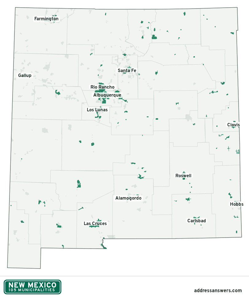
New Mexico city limits map image
The map above as a picture: every New Mexico municipality in green, with county lines. Boundaries from the Census Bureau, as of January 1, 2025.
You’re welcome to use it in a document or on your own site, with a link back to this page.
Download the map (PNG, 812 × 972)Questions about New Mexico city limits
How many municipalities are in New Mexico?
New Mexico has 105 incorporated places: 37 cities, 48 villages, and 20 towns, by the Census Bureau’s boundary files for 2025.
What is the largest city in New Mexico?
By population, Albuquerque, with about 562,218 residents (2020–2024 American Community Survey 5-year estimates). It is also the largest by land area, at 187.3 square miles.
What is the smallest village in New Mexico?
By the Census Bureau’s estimate, Folsom, with 11 residents. Estimates for places this small have a wide margin of error, so treat it as a rough count.
How much of New Mexico is unincorporated?
99% of its land and 687,481 of its residents (32%) are outside every municipality. There, local government is the county. The state also has 423 named unincorporated communities; the largest is South Valley.
Is South Valley, NM a city?
No. South Valley is a census-designated place: a community the Census Bureau maps for statistics, with no city government of its own. About 37,120 people live there, in unincorporated Bernalillo County. An address there is outside city limits, even if its mailing address says otherwise.
Is Chaparral, NM a city?
No. Chaparral is a census-designated place: a community the Census Bureau maps for statistics, with no city government of its own. About 18,186 people live there, in unincorporated Doña Ana County. An address there is outside city limits, even if its mailing address says otherwise.
Which municipalities in New Mexico are in more than one county?
Four of the 105 cross a county line, by at least 1% of their land. The largest: Rio Rancho (Sandoval and Bernalillo), Española (Rio Arriba and Santa Fe), and Edgewood (Santa Fe, Bernalillo, and Sandoval). Check an address to see which county it’s in.
Which county in New Mexico has the most municipalities?
Sandoval County, with 7 at least partly inside it. Los Alamos County has none.
Bordering states
More answers for a New Mexico address
Each tool checks the same address and puts its own answer first.
- County Census Your county, plus the township or town where those exist. Find your county
- School district Census The public school district that covers the address. Find your school district
- Flood zone FEMA The FEMA zone in plain English, and whether lenders require flood insurance. Check flood zone
- USDA home loans USDA Whether the property is in an area eligible for a USDA Rural Development loan. Check USDA eligibility
- Voting districts Census Your congressional district and your state senate and state house districts. Included in every check
Places, boundaries, land area and counties: US Census Bureau 2025 cartographic boundary files (boundaries as of January 1, 2025). A place is listed in each county that holds at least 1% of its land. Population: 2020–2024 American Community Survey 5-year estimates. Data updated October 24, 2026; page updated October 25, 2026. Boundaries change through annexation; your city or county has the official map.