Colorado city limits map
Colorado has 273 incorporated places: 75 cities and 198 towns. They cover 1.9% of the state’s land and are home to 75% of its residents. Everyone else lives outside city limits, where local government is the county. Enter an address to see which side of a city line it’s on.
Result for
The map couldn’t load. The answers don’t depend on it.
The boundary couldn’t load. The answer doesn’t depend on it.
Census Geocoder match
More about this address
Sources and limits
- Census
- US Census Bureau Geocoder, current boundaries
- FEMA
- National Flood Hazard Layer, effective flood maps
- USDA
- Rural Development property eligibility
- Map
- Boundaries from Census TIGERweb, flood zones drawn by FEMA, eligible areas from USDA, base map © OpenStreetMap contributors
Census boundaries are updated once a year, so a recent annexation may not show yet. Informational only, not an official determination. Verify with your city or county.
Colorado at a glance
- Incorporated places
- 273
- 75 cities and 198 towns
- Residents in city limits
- 75%
- 4,384,463 of 5,862,189
- Land in city limits
- 1.9%
- 2,020 of 103,637 sq mi
- Counties
- 64
- Every one has at least one
- Unincorporated communities
- 209
- Largest: Highlands Ranch (102,257)
- Largest city
- Denver
- 718,877 residents
City limits maps for 12 Colorado cities
Every Colorado city with 100,000 or more residents has its own page: the boundary in detail, the places around it and its school districts.
All 273 cities and towns in Colorado
Every incorporated place, largest first, with the counties it’s in and its size. An address inside one of these is inside city limits; anywhere else in the state is unincorporated.
| Name | Type | County | Population | Land (sq mi) |
|---|---|---|---|---|
| Denver | City | Denver | 718,877 | 153.1 |
| Colorado Springs | City | El Paso | 487,887 | 202.2 |
| Aurora | City | Arapahoe, Adams +1 | 394,432 | 164.1 |
| Fort Collins | City | Larimer | 170,229 | 57.2 |
| Lakewood | City | Jefferson | 156,583 | 43.5 |
| Thornton | City | Adams | 144,187 | 36.7 |
| Arvada | City | Jefferson, Adams | 122,634 | 39.0 |
| Westminster | City | Adams, Jefferson | 115,484 | 31.6 |
| Pueblo | City | Pueblo | 111,561 | 56.6 |
| Greeley | City | Weld | 110,806 | 50.6 |
| Centennial | City | Arapahoe | 108,201 | 30.2 |
| Boulder | City | Boulder | 106,433 | 26.9 |
| Longmont | City | Boulder, Weld | 99,406 | 29.3 |
| Castle Rock | Town | Douglas | 79,123 | 34.7 |
| Loveland | City | Larimer | 78,410 | 36.2 |
| Broomfield | City | Broomfield | 76,304 | 33.0 |
| Grand Junction | City | Mesa | 68,142 | 40.8 |
| Commerce City | City | Adams | 66,445 | 36.9 |
| Parker | Town | Douglas | 61,783 | 22.4 |
| Littleton | City | Arapahoe, Jefferson +1 | 44,710 | 12.6 |
| Brighton | City | Adams, Weld | 42,059 | 21.7 |
| Northglenn | City | Adams, Weld | 38,014 | 7.36 |
| Windsor | Town | Weld, Larimer | 37,914 | 26.3 |
| Englewood | City | Arapahoe | 34,129 | 6.56 |
| Erie | Town | Weld, Boulder | 33,808 | 21.5 |
| Wheat Ridge | City | Jefferson | 32,070 | 9.38 |
| Lafayette | City | Boulder | 30,602 | 9.26 |
| Fountain | City | El Paso | 29,300 | 22.3 |
| Evans | City | Weld | 22,396 | 10.6 |
| Montrose | City | Montrose | 21,044 | 19.1 |
| Louisville | City | Boulder | 20,786 | 7.98 |
| Golden | City | Jefferson | 20,417 | 9.64 |
| Durango | City | La Plata | 19,411 | 17.7 |
| Johnstown | Town | Weld, Larimer | 18,883 | 15.6 |
| Firestone | Town | Weld | 18,049 | 13.9 |
| Cañon City | City | Fremont | 17,122 | 12.4 |
| Frederick | Town | Weld | 16,651 | 15.2 |
| Greenwood Village | City | Arapahoe | 15,420 | 8.22 |
| Lone Tree | City | Douglas | 14,147 | 9.81 |
| Federal Heights | City | Adams | 14,125 | 1.77 |
| Fruita | City | Mesa | 13,691 | 8.01 |
| Steamboat Springs | City | Routt | 13,433 | 9.90 |
| Castle Pines | City | Douglas | 13,388 | 9.59 |
| Superior | Town | Boulder, Jefferson | 13,305 | 3.93 |
| Sterling | City | Logan | 13,172 | 7.62 |
| Berthoud | Town | Larimer, Weld | 12,411 | 13.1 |
| Wellington | Town | Larimer | 11,798 | 4.38 |
| Monument | Town | El Paso | 11,735 | 6.96 |
| Fort Morgan | City | Morgan | 11,605 | 5.38 |
| Rifle | City | Garfield | 10,570 | 7.08 |
| Glenwood Springs | City | Garfield | 10,241 | 5.83 |
| Severance | Town | Weld | 10,130 | 12.9 |
| Alamosa | City | Alamosa | 9,879 | 7.96 |
| Delta | City | Delta | 9,421 | 13.3 |
| Craig | City | Moffat | 8,991 | 5.07 |
| Cortez | City | Montezuma | 8,976 | 6.23 |
| Gypsum | Town | Eagle | 8,941 | 8.84 |
| Timnath | Town | Larimer, Weld | 8,941 | 7.85 |
| Fort Lupton | City | Weld | 8,897 | 13.5 |
| Milliken | Town | Weld | 8,871 | 13.0 |
| Lochbuie | Town | Weld, Adams | 8,609 | 3.68 |
| Trinidad | City | Las Animas | 8,286 | 9.38 |
| Woodland Park | City | Teller | 7,949 | 6.61 |
| Lamar | City | Prowers | 7,611 | 5.22 |
| Eagle | Town | Eagle | 7,442 | 5.84 |
| La Junta | City | Otero | 7,140 | 3.20 |
| Gunnison | City | Gunnison | 6,766 | 4.85 |
| Aspen | City | Pitkin | 6,756 | 3.86 |
| Carbondale | Town | Garfield | 6,637 | 2.08 |
| Dacono | City | Weld | 6,530 | 9.28 |
| Cherry Hills Village | City | Arapahoe | 6,354 | 6.21 |
| Sheridan | City | Arapahoe | 6,005 | 2.23 |
| Avon | Town | Eagle | 5,972 | 8.32 |
| Mead | Town | Weld | 5,919 | 15.5 |
| Eaton | Town | Weld | 5,867 | 3.16 |
| Salida | City | Chaffee | 5,861 | 2.87 |
| Estes Park | Town | Larimer | 5,844 | 6.69 |
| Brush | City | Morgan | 5,306 | 2.84 |
| Breckenridge | Town | Summit | 4,959 | 6.04 |
| Edgewater | City | Jefferson | 4,932 | 0.69 |
| New Castle | Town | Garfield | 4,880 | 2.50 |
| Silverthorne | Town | Summit | 4,815 | 4.05 |
| Manitou Springs | City | El Paso | 4,735 | 3.15 |
| Vail | Town | Eagle | 4,613 | 4.71 |
| Glendale | City | Arapahoe | 4,531 | 0.57 |
| Basalt | Town | Eagle, Pitkin | 4,335 | 2.02 |
| Monte Vista | City | Rio Grande | 4,141 | 2.64 |
| Florence | City | Fremont | 3,885 | 4.49 |
| Rocky Ford | City | Otero | 3,815 | 1.68 |
| Bennett | Town | Adams, Arapahoe | 3,663 | 7.14 |
| Silt | Town | Garfield | 3,642 | 1.68 |
| Yuma | City | Yuma | 3,459 | 3.27 |
| Orchard City | Town | Delta | 3,221 | 11.5 |
| Burlington | City | Kit Carson | 3,152 | 2.15 |
| Walsenburg | City | Huerfano | 3,072 | 2.99 |
| La Salle | Town | Weld | 3,061 | 0.98 |
| Buena Vista | Town | Chaffee | 3,010 | 3.94 |
| Snowmass Village | Town | Pitkin | 2,972 | 27.8 |
| Platteville | Town | Weld | 2,928 | 3.36 |
| Bayfield | Town | La Plata | 2,901 | 2.02 |
| Frisco | Town | Summit | 2,825 | 1.67 |
| Palmer Lake | Town | El Paso | 2,623 | 3.10 |
| Leadville | City | Lake | 2,620 | 1.17 |
| Palisade | Town | Mesa | 2,584 | 1.19 |
| Meeker | Town | Rio Blanco | 2,580 | 3.59 |
| Las Animas | City | Bent | 2,540 | 1.63 |
| Rangely | Town | Rio Blanco | 2,466 | 4.38 |
| Ault | Town | Weld | 2,425 | 1.77 |
| Cedaredge | Town | Delta | 2,398 | 1.96 |
| Holyoke | City | Phillips | 2,382 | 2.47 |
| Keenesburg | Town | Weld | 2,347 | 9.35 |
| Granby | Town | Grand | 2,270 | 12.7 |
| Elizabeth | Town | Elbert | 2,244 | 1.48 |
| Mountain Village | Town | San Miguel | 2,185 | 3.30 |
| Telluride | Town | San Miguel | 2,160 | 2.21 |
| Center | Town | Saguache, Rio Grande | 2,120 | 0.98 |
| Wray | City | Yuma | 2,114 | 3.46 |
| Pagosa Springs | Town | Archuleta | 2,090 | 5.06 |
| Hayden | Town | Routt | 2,057 | 3.44 |
| Columbine Valley | Town | Arapahoe | 2,047 | 0.98 |
| Hudson | Town | Weld | 2,006 | 5.90 |
| Idaho Springs | City | Clear Creek | 1,986 | 2.48 |
| Lyons | Town | Boulder | 1,838 | 1.36 |
| Kremmling | Town | Grand | 1,807 | 1.31 |
| Olathe | Town | Montrose | 1,793 | 1.51 |
| Akron | Town | Washington | 1,722 | 2.77 |
| Limon | Town | Lincoln | 1,678 | 3.16 |
| Paonia | Town | Delta | 1,661 | 0.83 |
| Nederland | Town | Boulder | 1,655 | 1.48 |
| Del Norte | Town | Rio Grande | 1,653 | 1.08 |
| Wiggins | Town | Morgan | 1,564 | 1.32 |
| Ordway | Town | Crowley | 1,528 | 0.78 |
| Parachute | Town | Garfield | 1,422 | 2.57 |
| Blue River | Town | Summit | 1,410 | 2.43 |
| Fraser | Town | Grand | 1,405 | 3.46 |
| Springfield | Town | Baca | 1,384 | 1.13 |
| Deer Trail | Town | Arapahoe | 1,275 | 1.27 |
| Ignacio | Town | La Plata | 1,250 | 0.51 |
| Ridgway | Town | Ouray | 1,237 | 1.85 |
| Crested Butte | Town | Gunnison | 1,229 | 0.87 |
| Hotchkiss | Town | Delta | 1,224 | 0.93 |
| Keystone | Town | Summit | 1,216 | 1.83 |
| Pierce | Town | Weld | 1,201 | 1.86 |
| Julesburg | Town | Sedgwick | 1,181 | 1.51 |
| Mancos | Town | Montezuma | 1,174 | 0.64 |
| Sanford | Town | Conejos | 1,142 | 1.46 |
| Hot Sulphur Springs | Town | Grand | 1,108 | 0.77 |
| Fairplay | Town | Park | 1,067 | 1.15 |
| Kersey | Town | Weld | 1,064 | 2.37 |
| Georgetown | Town | Clear Creek | 1,053 | 1.00 |
| Bow Mar | Town | Arapahoe, Jefferson | 1,047 | 0.66 |
| Gilcrest | Town | Weld | 1,026 | 0.81 |
| Minturn | Town | Eagle | 993 | 7.45 |
| Ouray | City | Ouray | 985 | 0.86 |
| Cheyenne Wells | Town | Cheyenne | 979 | 1.07 |
| Haxtun | Town | Phillips | 978 | 0.61 |
| Hugo | Town | Lincoln | 970 | 0.91 |
| Log Lane Village | Town | Morgan | 964 | 0.20 |
| Poncha Springs | Town | Chaffee | 959 | 2.71 |
| Cripple Creek | City | Teller | 955 | 1.52 |
| Fowler | Town | Otero | 936 | 0.56 |
| Manassa | Town | Conejos | 932 | 0.93 |
| Dolores | Town | Montezuma | 918 | 0.74 |
| Silver Cliff | Town | Custer | 863 | 15.5 |
| Winter Park | Town | Grand | 844 | 17.0 |
| Dillon | Town | Summit | 832 | 1.49 |
| Mount Crested Butte | Town | Gunnison | 823 | 2.07 |
| La Veta | Town | Huerfano | 804 | 1.37 |
| Williamsburg | Town | Fremont | 770 | 3.53 |
| South Fork | Town | Rio Grande | 724 | 2.54 |
| Stratton | Town | Kit Carson | 716 | 0.51 |
| Oak Creek | Town | Routt | 700 | 0.37 |
| Rockvale | Town | Fremont | 695 | 2.05 |
| Eads | Town | Kiowa | 677 | 0.49 |
| Kiowa | Town | Elbert | 673 | 0.86 |
| Empire | Town | Clear Creek | 672 | 0.29 |
| Holly | Town | Prowers | 665 | 0.73 |
| Foxfield | Town | Arapahoe | 659 | 1.32 |
| Dove Creek | Town | Dolores | 651 | 0.57 |
| Silverton | Town | San Juan | 637 | 0.83 |
| Flagler | Town | Kit Carson | 635 | 1.43 |
| Calhan | Town | El Paso | 620 | 0.91 |
| Fleming | Town | Logan | 614 | 0.49 |
| Mountain View | Town | Jefferson | 609 | 0.09 |
| Nucla | Town | Montrose | 598 | 0.69 |
| Naturita | Town | Montrose | 589 | 0.62 |
| Antonito | Town | Conejos | 579 | 0.43 |
| Saguache | Town | Saguache | 579 | 0.39 |
| Walden | Town | Jackson | 573 | 0.34 |
| Lake City | Town | Hinsdale | 561 | 0.83 |
| San Luis | Town | Costilla | 560 | 0.57 |
| Olney Springs | Town | Crowley | 557 | 0.24 |
| Central | City | Gilpin, Clear Creek | 525 | 2.78 |
| La Jara | Town | Conejos | 522 | 0.41 |
| Otis | Town | Washington | 521 | 0.41 |
| Dinosaur | Town | Moffat | 507 | 0.93 |
| Walsh | Town | Baca | 492 | 0.45 |
| Ovid | Town | Sedgwick | 468 | 0.16 |
| Sugar City | Town | Crowley | 464 | 0.38 |
| Green Mountain Falls | Town | El Paso, Teller | 459 | 1.16 |
| De Beque | Town | Mesa | 458 | 2.78 |
| Crawford | Town | Delta | 448 | 0.25 |
| Granada | Town | Prowers | 447 | 0.69 |
| Simla | Town | Elbert | 423 | 0.65 |
| Swink | Town | Otero | 422 | 0.28 |
| Wiley | Town | Prowers | 422 | 0.34 |
| Westcliffe | Town | Custer | 419 | 1.23 |
| Rico | Town | Dolores | 414 | 0.68 |
| Morrison | Town | Jefferson | 412 | 1.65 |
| Aguilar | Town | Las Animas | 401 | 0.39 |
| Garden City | Town | Weld | 401 | 0.11 |
| Victor | City | Teller | 388 | 0.29 |
| Romeo | Town | Conejos | 387 | 0.23 |
| Alma | Town | Park | 385 | 0.43 |
| Norwood | Town | San Miguel | 381 | 0.35 |
| Manzanola | Town | Otero | 361 | 0.28 |
| Nunn | Town | Weld | 358 | 3.98 |
| Collbran | Town | Mesa | 356 | 0.56 |
| Grand Lake | Town | Grand | 333 | 1.08 |
| Eckley | Town | Yuma | 332 | 0.47 |
| Coal Creek | Town | Fremont | 324 | 1.19 |
| Jamestown | Town | Boulder | 324 | 0.57 |
| Marble | Town | Gunnison | 309 | 0.36 |
| Red Cliff | Town | Eagle | 308 | 0.24 |
| Arriba | Town | Lincoln | 307 | 0.50 |
| Yampa | Town | Routt | 296 | 0.25 |
| Merino | Town | Logan | 286 | 0.15 |
| City of Creede | Town | Mineral | 285 | 0.95 |
| Hillrose | Town | Morgan | 285 | 0.19 |
| Brookside | Town | Fremont | 276 | 0.47 |
| Kit Carson | Town | Cheyenne | 273 | 0.59 |
| Iliff | Town | Logan | 268 | 0.19 |
| Peetz | Town | Logan | 265 | 0.22 |
| Boone | Town | Pueblo | 262 | 0.38 |
| Blanca | Town | Costilla | 230 | 1.83 |
| Crowley | Town | Crowley | 219 | 0.23 |
| Bethune | Town | Kit Carson | 218 | 0.16 |
| Sedgwick | Town | Sedgwick | 198 | 0.39 |
| Genoa | Town | Lincoln | 190 | 0.31 |
| Vona | Town | Kit Carson | 189 | 0.22 |
| Cheraw | Town | Otero | 188 | 0.18 |
| Vilas | Town | Baca | 184 | 0.13 |
| Grover | Town | Weld | 164 | 0.60 |
| Cokedale | Town | Las Animas | 161 | 0.20 |
| Crook | Town | Logan | 157 | 0.14 |
| Hooper | Town | Alamosa | 152 | 0.25 |
| Pritchett | Town | Baca | 142 | 0.23 |
| Seibert | Town | Kit Carson | 138 | 0.34 |
| Larkspur | Town | Douglas | 131 | 1.59 |
| Pitkin | Town | Gunnison | 131 | 0.26 |
| Ramah | Town | El Paso | 127 | 0.25 |
| Silver Plume | Town | Clear Creek | 127 | 0.26 |
| Crestone | Town | Saguache | 123 | 0.38 |
| Rye | Town | Pueblo | 121 | 0.09 |
| Montezuma | Town | Summit | 120 | 0.08 |
| Ophir | Town | San Miguel | 120 | 0.24 |
| Black Hawk | City | Gilpin | 106 | 3.12 |
| Ward | Town | Boulder | 103 | 0.54 |
| Starkville | Town | Las Animas | 102 | 0.07 |
| Kim | Town | Las Animas | 78 | 0.38 |
| Raymer (New Raymer) | Town | Weld | 78 | 0.78 |
| Branson | Town | Las Animas | 62 | 0.24 |
| Sheridan Lake | Town | Kiowa | 61 | 0.31 |
| Campo | Town | Baca | 58 | 0.14 |
| Moffat | Town | Saguache | 54 | 2.12 |
| Haswell | Town | Kiowa | 52 | 0.80 |
| Paoli | Town | Phillips | 43 | 0.30 |
| Hartman | Town | Prowers | 30 | 0.27 |
| Bonanza | Town | Saguache | 20 | 0.44 |
| Two Buttes | Town | Baca | 15 | 0.25 |
| Sawpit | Town | San Miguel | 6 | 0.03 |
| Lakeside | Town | Jefferson | 4 | 0.19 |
| Carbonate | Town | Garfield | 0 | 0.99 |
Showing 1–50 of 273
Unincorporated communities in Colorado
Census-designated places: named communities the Census Bureau maps for statistics, with no city government of their own. An address in one is outside city limits, even when its mailing address names a city. Colorado has 209.
| Community | County | Population | Land (sq mi) |
|---|---|---|---|
| Highlands Ranch | Douglas | 102,257 | 24.3 |
| Security-Widefield | El Paso | 37,345 | 12.9 |
| Pueblo West | Pueblo | 35,681 | 49.6 |
| Dakota Ridge | Jefferson | 33,753 | 9.39 |
| Ken Caryl | Jefferson | 33,233 | 9.83 |
| Columbine | Jefferson | 25,478 | 6.63 |
| Four Square Mile | Arapahoe | 23,024 | 2.70 |
| Cimarron Hills | El Paso | 19,817 | 5.89 |
| Clifton | Mesa | 19,518 | 5.98 |
| Sherrelwood | Adams | 18,692 | 2.45 |
| Fort Carson | El Paso | 18,019 | 28.0 |
| Welby | Adams | 16,197 | 3.69 |
| Black Forest | El Paso | 15,738 | 100.6 |
| The Pinery | Douglas | 11,871 | 10.4 |
| Berkley | Adams | 10,789 | 3.59 |
| Edwards | Eagle | 10,785 | 26.6 |
| Cherry Creek | Arapahoe | 10,721 | 1.67 |
| Gunbarrel | Boulder | 10,051 | 6.25 |
| Fairmount | Jefferson | 9,902 | 6.08 |
| Roxborough Park | Douglas | 9,085 | 9.23 |
| Woodmoor | El Paso | 8,934 | 6.08 |
| Stonegate | Douglas | 8,906 | 1.83 |
| Redlands | Mesa | 8,868 | 12.9 |
| Evergreen | Jefferson | 8,602 | 11.5 |
| Derby | Adams | 8,453 | 1.75 |
| Applewood | Jefferson | 8,350 | 4.07 |
| Twin Lakes | Adams | 8,030 | 1.64 |
| Fruitvale | Mesa | 8,019 | 2.82 |
| Orchard Mesa | Mesa | 6,945 | 3.64 |
| Air Force Academy | El Paso | 6,727 | 9.99 |
| Gleneagle | El Paso | 6,440 | 2.31 |
| Battlement Mesa | Garfield | 5,755 | 11.2 |
| Meridian | Douglas | 5,634 | 2.56 |
| Shaw Heights | Adams | 5,565 | 0.68 |
| Stratmoor | El Paso | 5,412 | 2.64 |
| Todd Creek | Adams | 5,379 | 9.89 |
| West Pleasant View | Jefferson | 5,051 | 1.53 |
| Dove Valley | Arapahoe | 4,806 | 3.13 |
| Castle Pines Village | Douglas | 4,436 | 4.45 |
| Sterling Ranch | Douglas | 4,213 | 5.53 |
| Penrose | Fremont | 4,087 | 17.8 |
| Lincoln Park | Fremont | 3,986 | 3.79 |
| Genesee | Jefferson | 3,778 | 6.62 |
| Sierra Ridge | Douglas | 3,663 | 0.51 |
| Strasburg | Arapahoe | 3,455 | 20.8 |
| Ponderosa Park | Elbert | 3,453 | 14.4 |
| Niwot | Boulder | 3,447 | 4.00 |
| Stepping Stone | Douglas | 3,137 | 0.73 |
| El Jebel | Eagle | 2,941 | 5.31 |
| Inverness | Arapahoe | 2,934 | 1.13 |
| Meridian Village | Douglas | 2,699 | 0.51 |
| Acres Green | Douglas | 2,639 | 0.60 |
| Park Center | Fremont | 2,588 | 6.55 |
| Holly Hills | Arapahoe | 2,572 | 0.58 |
| Coal Creek | Jefferson | 2,346 | 9.37 |
| Laporte | Larimer | 1,771 | 6.12 |
| Aristocrat Ranchettes | Weld | 1,747 | 1.24 |
| Byers | Arapahoe | 1,726 | 11.5 |
| Colorado City | Pueblo | 1,615 | 15.0 |
| Perry Park | Douglas | 1,570 | 8.55 |
| Leadville North | Lake | 1,417 | 2.45 |
| Cascade-Chipita Park | El Paso | 1,412 | 13.3 |
| Ellicott | El Paso | 1,404 | 10.9 |
| Loma | Mesa | 1,350 | 10.9 |
| Dotsero | Eagle | 1,306 | 1.36 |
| Alamosa East | Alamosa | 1,298 | 3.25 |
| Towaoc | Montezuma | 1,078 | 3.58 |
| Aetna Estates | Arapahoe | 1,010 | 0.13 |
| Indian Hills | Jefferson | 986 | 5.42 |
| Howard | Fremont | 966 | 16.7 |
| Upper Bear Creek | Clear Creek | 954 | 3.79 |
| Watkins | Arapahoe | 847 | 24.7 |
| Floyd Hill | Clear Creek | 841 | 6.29 |
| East Pleasant View | Jefferson | 832 | 0.09 |
| Salt Creek | Pueblo | 832 | 0.43 |
| Allenspark | Boulder | 825 | 11.9 |
| Kittredge | Jefferson | 812 | 1.88 |
| Lazy Acres | Boulder | 778 | 5.29 |
| Beulah Valley | Pueblo | 751 | 2.57 |
| Aspen Park | Jefferson | 742 | 2.46 |
| Upper Witter Gulch | Clear Creek | 731 | 0.91 |
| Paragon Estates | Boulder | 667 | 1.68 |
| Blende | Pueblo | 623 | 0.84 |
| Loghill Village | Ouray | 618 | 6.21 |
| Twin Lakes | Lake | 615 | 6.73 |
| Altona | Boulder | 587 | 1.69 |
| Grand View Estates | Douglas | 567 | 1.00 |
| Pine Brook Hill | Boulder | 543 | 3.03 |
| Coaldale | Fremont | 538 | 31.0 |
| North La Junta | Otero | 535 | 1.36 |
| Sugarloaf | Boulder | 474 | 2.18 |
| Franktown | Douglas | 472 | 2.94 |
| Tabernash | Grand | 466 | 4.83 |
| Eldora | Boulder | 465 | 4.16 |
| Chacra | Garfield | 457 | 0.95 |
| St. Ann Highlands | Boulder | 453 | 1.39 |
| Fort Garland | Costilla | 446 | 0.38 |
| Mulford | Garfield | 413 | 0.67 |
| Vineland | Pueblo | 410 | 0.57 |
| Cattle Creek | Garfield | 396 | 1.30 |
| Pine Valley | Clear Creek | 392 | 0.82 |
| Phippsburg | Routt | 390 | 1.21 |
| Arboles | Archuleta | 389 | 5.16 |
| Redvale | Montrose | 389 | 4.68 |
| Tall Timber | Boulder | 382 | 0.57 |
| Red Feather Lakes | Larimer | 365 | 9.12 |
| Brook Forest | Jefferson | 355 | 1.39 |
| Copper Mountain | Summit | 353 | 32.1 |
| Downieville-Lawson-Dumont | Clear Creek | 345 | 0.78 |
| Avondale | Pueblo | 338 | 0.63 |
| Placerville | San Miguel | 333 | 0.77 |
| Gerrard | Rio Grande | 332 | 1.20 |
| Sunshine | Boulder | 330 | 1.73 |
| Eldorado Springs | Boulder | 320 | 2.58 |
| Idledale | Jefferson | 297 | 0.28 |
| Louviers | Douglas | 294 | 1.58 |
| North Washington | Adams | 294 | 5.20 |
| Comanche Creek | Arapahoe | 283 | 21.7 |
| Morgan Heights | Morgan | 281 | 0.29 |
| Lewis | Montezuma | 277 | 3.11 |
| No Name | Garfield | 269 | 0.18 |
| Crisman | Boulder | 268 | 1.46 |
| Rollinsville | Gilpin | 264 | 1.41 |
| Catherine | Garfield | 255 | 0.86 |
| Jackson Lake | Morgan | 238 | 3.06 |
| Westcreek | Douglas | 237 | 1.22 |
| Maysville | Chaffee | 235 | 12.4 |
| Bark Ranch | Boulder | 199 | 0.86 |
| Lazear | Delta | 196 | 1.60 |
| Florissant | Teller | 192 | 0.52 |
| Smeltertown | Chaffee | 188 | 0.15 |
| Nathrop | Chaffee | 187 | 0.72 |
| Capulin | Conejos | 185 | 0.95 |
| Seven Hills | Boulder | 183 | 0.49 |
| Midland | Teller | 182 | 1.72 |
| Echo Hills | Clear Creek | 180 | 0.57 |
| Mountain Meadows | Boulder | 180 | 1.72 |
| Gold Hill | Boulder | 178 | 2.08 |
| Elbert | Elbert | 164 | 0.55 |
| Gardner | Huerfano | 162 | 2.47 |
| Goldfield | Teller | 160 | 0.14 |
| El Moro | Las Animas | 151 | 11.1 |
| Redstone | Pitkin | 144 | 0.44 |
| Segundo | Las Animas | 143 | 0.69 |
| Peyton | El Paso | 139 | 2.30 |
| Johnson Village | Chaffee | 129 | 0.30 |
| McClave | Bent | 128 | 1.91 |
| Hasty | Bent | 125 | 2.75 |
| Portland | Ouray | 125 | 3.20 |
| Blue Valley | Clear Creek | 120 | 1.05 |
| La Junta Gardens | Otero | 112 | 0.53 |
| Woody Creek | Pitkin | 109 | 0.61 |
| Colona | Ouray | 108 | 0.06 |
| Weldona | Morgan | 106 | 0.16 |
| Brick Center | Arapahoe | 105 | 5.78 |
| Joes | Yuma | 105 | 0.75 |
| Marvel | La Plata | 100 | 0.13 |
| Rock Creek Park | El Paso | 97 | 0.27 |
| Garfield | Chaffee | 93 | 0.34 |
| Idalia | Yuma | 90 | 0.09 |
| Briggsdale | Weld | 88 | 0.44 |
| Orchard | Morgan | 88 | 0.16 |
| Divide | Teller | 87 | 0.34 |
| Amherst | Phillips | 82 | 0.45 |
| Jansen | Las Animas | 81 | 1.17 |
| Somerset | Gunnison | 79 | 0.18 |
| Alpine | Rio Grande | 75 | 1.05 |
| Peoria | Arapahoe | 75 | 13.8 |
| Glendale | Boulder | 69 | 1.26 |
| St. Mary's | Clear Creek | 68 | 1.44 |
| Southern Ute | La Plata | 67 | 16.0 |
| Heeney | Summit | 63 | 0.23 |
| Atwood | Logan | 62 | 1.03 |
| San Acacio | Costilla | 61 | 1.26 |
| Cope | Washington | 58 | 1.80 |
| Piedra | Hinsdale | 57 | 11.6 |
| Bonanza Mountain Estates | Boulder | 56 | 0.17 |
| Arapahoe | Cheyenne | 53 | 0.28 |
| Snyder | Morgan | 51 | 0.35 |
| Stonewall Gap | Las Animas | 45 | 1.92 |
| Cotopaxi | Fremont | 41 | 0.29 |
| Hoehne | Las Animas | 40 | 3.11 |
| Sedalia | Douglas | 37 | 1.36 |
| Towner | Kiowa | 36 | 0.04 |
| Maybell | Moffat | 35 | 0.52 |
| Matheson | Elbert | 34 | 1.72 |
| Guffey | Park | 29 | 8.67 |
| Hidden Lake | Boulder | 29 | 0.61 |
| Saddle Ridge | Morgan | 27 | 0.17 |
| Trail Side | Morgan | 27 | 0.73 |
| Valmont | Boulder | 27 | 0.26 |
| Kirk | Yuma | 26 | 0.16 |
| Valdez | Las Animas | 26 | 1.61 |
| Parshall | Grand | 25 | 0.30 |
| Weston | Las Animas | 24 | 3.10 |
| Blue Sky | Morgan | 19 | 0.04 |
| Cathedral | Hinsdale | 13 | 21.3 |
| Brandon | Kiowa | 8 | 0.12 |
| Padroni | Logan | 7 | 0.81 |
| Laird | Yuma | 4 | 0.15 |
| Conejos | Conejos | 0 | 0.48 |
| Fulford | Eagle | 0 | 0.22 |
| Hartsel | Park | 0 | 0.20 |
| Leyner | Boulder | 0 | 0.20 |
| Lynn | Las Animas | 0 | 0.72 |
| McCoy | Eagle | 0 | 0.29 |
| Norrie | Pitkin | 0 | 0.19 |
| Vernon | Yuma | 0 | 1.13 |
| Wolcott | Eagle | 0 | 0.37 |
Showing 1–50 of 209
Counties in Colorado
64 counties, with how many cities and towns have land in each and the largest whose main county it is.
| County | Cities | Largest | Population | Land (sq mi) |
|---|---|---|---|---|
| El Paso County | 8 | Colorado Springs | 742,999 | 2,126 |
| Denver County | 1 | Denver | 718,877 | 153.1 |
| Arapahoe County | 13 | Aurora | 659,844 | 797.9 |
| Jefferson County | 12 | Lakewood | 579,377 | 764.4 |
| Adams County | 10 | Thornton | 530,225 | 1,167 |
| Douglas County | 7 | Castle Rock | 377,150 | 840.9 |
| Larimer County | 8 | Fort Collins | 367,368 | 2,596 |
| Weld County | 31 | Greeley | 350,396 | 3,985 |
| Boulder County | 10 | Boulder | 328,961 | 726.4 |
| Pueblo County | 3 | Pueblo | 169,356 | 2,387 |
| Mesa County | 5 | Grand Junction | 158,601 | 3,329 |
| Broomfield County | 1 | Broomfield | 76,304 | 33.0 |
| Garfield County | 7 | Rifle | 62,479 | 2,947 |
| La Plata County | 3 | Durango | 56,331 | 1,690 |
| Eagle County | 7 | Gypsum | 55,135 | 1,685 |
| Fremont County | 6 | Cañon City | 49,634 | 1,534 |
| Montrose County | 4 | Montrose | 43,807 | 2,241 |
| Delta County | 6 | Delta | 31,598 | 1,142 |
| Summit County | 7 | Breckenridge | 31,017 | 608.3 |
| Morgan County | 5 | Fort Morgan | 29,520 | 1,281 |
| Elbert County | 3 | Elizabeth | 27,874 | 1,850 |
| Montezuma County | 3 | Cortez | 26,412 | 2,029 |
| Routt County | 4 | Steamboat Springs | 25,084 | 2,362 |
| Teller County | 4 | Woodland Park | 24,825 | 557.1 |
| Logan County | 6 | Sterling | 20,892 | 1,839 |
| Chaffee County | 3 | Salida | 20,178 | 1,013 |
| Otero County | 6 | La Junta | 18,321 | 1,262 |
| Park County | 2 | Fairplay | 17,907 | 2,194 |
| Gunnison County | 5 | Gunnison | 17,241 | 3,239 |
| Pitkin County | 3 | Aspen | 16,985 | 970.7 |
| Alamosa County | 2 | Alamosa | 16,581 | 722.6 |
| Grand County | 6 | Granby | 15,895 | 1,847 |
| Las Animas County | 6 | Trinidad | 14,413 | 4,773 |
| Archuleta County | 1 | Pagosa Springs | 13,900 | 1,350 |
| Moffat County | 2 | Craig | 13,207 | 4,743 |
| Prowers County | 5 | Lamar | 11,910 | 1,638 |
| Rio Grande County | 4 | Monte Vista | 11,321 | 912.0 |
| Yuma County | 3 | Yuma | 9,979 | 2,364 |
| Clear Creek County | 5 | Idaho Springs | 9,262 | 395.1 |
| San Miguel County | 5 | Mountain Village | 7,968 | 1,287 |
| Conejos County | 5 | Sanford | 7,530 | 1,287 |
| Lake County | 1 | Leadville | 7,380 | 376.9 |
| Kit Carson County | 6 | Burlington | 7,023 | 2,161 |
| Huerfano County | 2 | Walsenburg | 6,972 | 1,591 |
| Saguache County | 5 | Center | 6,580 | 3,169 |
| Rio Blanco County | 2 | Meeker | 6,544 | 3,221 |
| Gilpin County | 2 | Central | 5,901 | 150.0 |
| Crowley County | 4 | Ordway | 5,647 | 787.4 |
| Lincoln County | 4 | Limon | 5,550 | 2,578 |
| Bent County | 1 | Las Animas | 5,549 | 1,513 |
| Custer County | 2 | Silver Cliff | 5,247 | 738.6 |
| Ouray County | 2 | Ridgway | 5,087 | 540.7 |
| Washington County | 2 | Akron | 4,831 | 2,518 |
| Phillips County | 3 | Holyoke | 4,496 | 687.9 |
| Costilla County | 2 | San Luis | 3,607 | 1,228 |
| Baca County | 6 | Springfield | 3,428 | 2,555 |
| Dolores County | 2 | Dove Creek | 2,432 | 1,067 |
| Sedgwick County | 3 | Julesburg | 2,304 | 548.0 |
| Cheyenne County | 2 | Cheyenne Wells | 1,741 | 1,778 |
| Kiowa County | 3 | Eads | 1,376 | 1,768 |
| Jackson County | 1 | Walden | 1,372 | 1,614 |
| Hinsdale County | 1 | Lake City | 1,005 | 1,117 |
| Mineral County | 1 | City of Creede | 729 | 875.8 |
| San Juan County | 1 | Silverton | 724 | 387.5 |
Showing 1–50 of 64
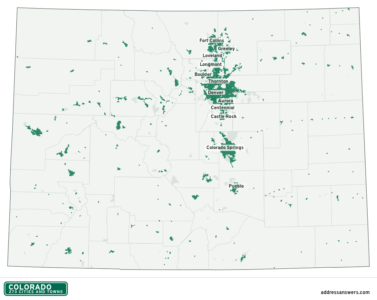
Colorado city limits map image
The map above as a picture: every Colorado city and town in green, with county lines. Boundaries from the Census Bureau, as of January 1, 2025.
You’re welcome to use it in a document or on your own site, with a link back to this page.
Download the map (PNG, 1,200 × 956)Questions about Colorado city limits
How many cities and towns are in Colorado?
Colorado has 273 incorporated places: 75 cities and 198 towns, by the Census Bureau’s boundary files for 2025.
What is the largest city in Colorado?
By population, Denver, with about 718,877 residents (2020–2024 American Community Survey 5-year estimates). By land area the largest is Colorado Springs, at 202.2 square miles (Denver: 153.1).
What is the smallest town in Colorado?
By the Census Bureau’s estimate, Lakeside, with 4 residents. Estimates for places this small have a wide margin of error, so treat it as a rough count.
How much of Colorado is unincorporated?
98% of its land and 1.5 million of its residents (25%) are outside every city or town. There, local government is the county. The state also has 209 named unincorporated communities; the largest is Highlands Ranch.
Is Highlands Ranch, CO a city?
No. Highlands Ranch is a census-designated place: a community the Census Bureau maps for statistics, with no city government of its own. About 102,257 people live there, in unincorporated Douglas County. An address there is outside city limits, even if its mailing address says otherwise.
Is Security-Widefield, CO a city?
No. Security-Widefield is a census-designated place: a community the Census Bureau maps for statistics, with no city government of its own. About 37,345 people live there, in unincorporated El Paso County. An address there is outside city limits, even if its mailing address says otherwise.
Which cities and towns in Colorado are in more than one county?
20 of the 273 cross a county line, by at least 1% of their land. The largest: Aurora (Arapahoe, Adams, and Douglas), Arvada (Jefferson and Adams), and Westminster (Adams and Jefferson). Check an address to see which county it’s in.
Which county in Colorado has the most cities and towns?
Weld County, with 31 at least partly inside it. Every county in Colorado has at least one.
Bordering states
More answers for a Colorado address
Each tool checks the same address and puts its own answer first.
- County Census Your county, plus the township or town where those exist. Find your county
- School district Census The public school district that covers the address. Find your school district
- Flood zone FEMA The FEMA zone in plain English, and whether lenders require flood insurance. Check flood zone
- USDA home loans USDA Whether the property is in an area eligible for a USDA Rural Development loan. Check USDA eligibility
- Voting districts Census Your congressional district and your state senate and state house districts. Included in every check
Places, boundaries, land area and counties: US Census Bureau 2025 cartographic boundary files (boundaries as of January 1, 2025). A place is listed in each county that holds at least 1% of its land. Population: 2020–2024 American Community Survey 5-year estimates. Data updated October 24, 2026; page updated October 25, 2026. Boundaries change through annexation; your city or county has the official map.