Arizona city limits map
Arizona has 91 incorporated places: 46 cities and 45 towns. They cover 4.1% of the state’s land and are home to 80% of its residents. Everyone else lives outside city limits, where local government is the county. Enter an address to see which side of a city line it’s on.
Result for
The map couldn’t load. The answers don’t depend on it.
The boundary couldn’t load. The answer doesn’t depend on it.
Census Geocoder match
More about this address
Sources and limits
- Census
- US Census Bureau Geocoder, current boundaries
- FEMA
- National Flood Hazard Layer, effective flood maps
- USDA
- Rural Development property eligibility
- Map
- Boundaries from Census TIGERweb, flood zones drawn by FEMA, eligible areas from USDA, base map © OpenStreetMap contributors
Census boundaries are updated once a year, so a recent annexation may not show yet. Informational only, not an official determination. Verify with your city or county.
Arizona at a glance
- Incorporated places
- 91
- 46 cities and 45 towns
- Residents in city limits
- 80%
- 5,913,813 of 7,378,838
- Land in city limits
- 4.1%
- 4,617 of 113,655 sq mi
- Counties
- 15
- Every one has at least one
- Unincorporated communities
- 376
- Largest: San Tan Valley (109,189)
- Largest city
- Phoenix
- 1.6 million residents
City limits maps for 13 Arizona cities
Every Arizona city with 100,000 or more residents has its own page: the boundary in detail, the places around it and its school districts.
All 91 cities and towns in Arizona
Every incorporated place, largest first, with the counties it’s in and its size. An address inside one of these is inside city limits; anywhere else in the state is unincorporated.
| Name | Type | County | Population | Land (sq mi) |
|---|---|---|---|---|
| Phoenix | City | Maricopa | 1,642,323 | 518.4 |
| Tucson | City | Pima | 547,073 | 242.9 |
| Mesa | City | Maricopa | 511,764 | 142.0 |
| Gilbert | Town | Maricopa | 280,262 | 68.8 |
| Chandler | City | Maricopa | 280,136 | 65.7 |
| Glendale | City | Maricopa | 252,833 | 67.3 |
| Scottsdale | City | Maricopa | 243,821 | 184.0 |
| Peoria | City | Maricopa, Yavapai | 196,906 | 176.7 |
| Tempe | City | Maricopa | 188,065 | 40.0 |
| Surprise | City | Maricopa | 154,948 | 110.5 |
| Goodyear | City | Maricopa | 107,645 | 191.3 |
| Buckeye | City | Maricopa | 104,923 | 395.8 |
| Yuma | City | Yuma | 100,139 | 121.1 |
| Avondale | City | Maricopa | 92,477 | 47.8 |
| Flagstaff | City | Coconino | 76,445 | 66.0 |
| Queen Creek | Town | Maricopa, Pinal | 71,867 | 42.0 |
| Maricopa | City | Pinal | 67,163 | 42.5 |
| Casa Grande | City | Pinal | 60,905 | 114.2 |
| Lake Havasu City | City | Mohave | 58,359 | 46.3 |
| Marana | Town | Pima | 56,938 | 121.7 |
| Prescott Valley | Town | Yavapai | 49,179 | 40.4 |
| Oro Valley | Town | Pima | 48,162 | 35.1 |
| Prescott | City | Yavapai | 47,400 | 49.4 |
| Sierra Vista | City | Cochise | 45,155 | 152.4 |
| Bullhead City | City | Mohave | 42,496 | 59.4 |
| Apache Junction | City | Pinal | 41,058 | 45.5 |
| San Luis | City | Yuma | 37,337 | 33.8 |
| El Mirage | City | Maricopa | 36,088 | 9.91 |
| Sahuarita | Town | Pima | 35,862 | 31.7 |
| Kingman | City | Mohave | 34,375 | 37.5 |
| Florence | Town | Pinal | 25,570 | 62.7 |
| Fountain Hills | Town | Maricopa | 23,789 | 20.3 |
| Nogales | City | Santa Cruz | 19,841 | 20.8 |
| Eloy | City | Pinal | 17,433 | 114.7 |
| Coolidge | City | Pinal | 16,636 | 83.5 |
| Payson | Town | Gila | 16,622 | 19.3 |
| Douglas | City | Cochise | 15,981 | 9.98 |
| Somerton | City | Yuma | 14,574 | 7.27 |
| Chino Valley | Town | Yavapai | 13,602 | 62.5 |
| Paradise Valley | Town | Maricopa | 12,611 | 15.4 |
| Cottonwood | City | Yavapai | 12,580 | 28.2 |
| Camp Verde | Town | Yavapai | 12,521 | 42.3 |
| Show Low | City | Navajo | 12,102 | 65.5 |
| Safford | City | Graham | 10,239 | 9.28 |
| Sedona | City | Yavapai, Coconino | 9,777 | 18.3 |
| Winslow | City | Navajo | 8,773 | 13.0 |
| Wickenburg | Town | Maricopa, Yavapai | 8,059 | 27.0 |
| Tolleson | City | Maricopa | 7,668 | 5.73 |
| Page | City | Coconino | 7,345 | 38.2 |
| Globe | City | Gila | 7,195 | 18.2 |
| Youngtown | Town | Maricopa | 7,015 | 1.49 |
| Litchfield Park | City | Maricopa | 6,916 | 3.28 |
| Snowflake | Town | Navajo | 6,444 | 33.7 |
| Thatcher | Town | Graham | 5,439 | 6.66 |
| Benson | City | Cochise | 5,417 | 41.6 |
| Guadalupe | Town | Maricopa | 5,272 | 0.80 |
| Cave Creek | Town | Maricopa | 5,091 | 37.7 |
| Bisbee | City | Cochise | 4,977 | 5.18 |
| Holbrook | City | Navajo | 4,858 | 17.3 |
| Clarkdale | Town | Yavapai | 4,758 | 10.2 |
| South Tucson | City | Pima | 4,550 | 1.03 |
| Dewey-Humboldt | Town | Yavapai | 4,501 | 18.8 |
| Eagar | Town | Apache | 4,416 | 12.3 |
| Taylor | Town | Navajo | 4,183 | 32.7 |
| Pinetop-Lakeside | Town | Navajo | 4,101 | 11.1 |
| Clifton | Town | Greenlee | 3,822 | 14.7 |
| Carefree | Town | Maricopa | 3,683 | 8.81 |
| St. Johns | City | Apache | 3,395 | 25.9 |
| Parker | Town | La Paz | 3,388 | 22.0 |
| Williams | City | Coconino | 3,369 | 43.8 |
| Willcox | City | Cochise | 3,222 | 6.62 |
| Pima | Town | Graham | 2,995 | 7.35 |
| Colorado City | Town | Mohave | 2,702 | 8.92 |
| Superior | Town | Pinal | 2,535 | 11.4 |
| Wellton | Town | Yuma | 2,527 | 29.0 |
| Star Valley | Town | Gila | 2,525 | 36.1 |
| Kearny | Town | Pinal | 2,109 | 2.70 |
| Springerville | Town | Apache | 2,008 | 11.5 |
| Quartzsite | Town | La Paz | 1,877 | 36.3 |
| Huachuca City | Town | Cochise | 1,614 | 2.83 |
| Miami | Town | Gila | 1,405 | 0.89 |
| Gila Bend | Town | Maricopa | 1,363 | 64.4 |
| Mammoth | Town | Pinal | 1,191 | 26.3 |
| Fredonia | Town | Coconino | 1,061 | 8.88 |
| Tombstone | City | Cochise | 1,026 | 9.25 |
| Duncan | Town | Greenlee | 969 | 2.15 |
| Patagonia | Town | Santa Cruz | 946 | 1.29 |
| Tusayan | Town | Coconino | 368 | 16.8 |
| Hayden | Town | Gila | 331 | 1.27 |
| Jerome | Town | Yavapai | 231 | 0.79 |
| Winkelman | Town | Pinal, Gila | 191 | 0.77 |
Showing 1–50 of 91
Unincorporated communities in Arizona
Census-designated places: named communities the Census Bureau maps for statistics, with no city government of their own. An address in one is outside city limits, even when its mailing address names a city. Arizona has 376.
| Community | County | Population | Land (sq mi) |
|---|---|---|---|
| San Tan Valley | Pinal | 109,189 | 75.8 |
| Casas Adobes | Pima | 72,059 | 26.5 |
| Catalina Foothills | Pima | 52,593 | 41.8 |
| Sun City | Maricopa | 37,486 | 14.4 |
| Fortuna Foothills | Yuma | 28,896 | 40.1 |
| Drexel Heights | Pima | 27,675 | 19.2 |
| Sun City West | Maricopa | 27,425 | 11.9 |
| Anthem | Maricopa | 22,584 | 7.92 |
| Green Valley | Pima | 22,114 | 19.7 |
| Rio Rico | Santa Cruz | 22,017 | 63.1 |
| New River | Maricopa | 18,240 | 56.1 |
| Flowing Wells | Pima | 16,559 | 3.81 |
| Vail | Pima | 16,315 | 22.7 |
| Tanque Verde | Pima | 15,866 | 32.3 |
| Fort Mohave | Mohave | 15,715 | 16.7 |
| Valencia West | Pima | 14,728 | 10.5 |
| Sierra Vista Southeast | Cochise | 14,330 | 110.7 |
| New Kingman-Butler | Mohave | 13,993 | 4.97 |
| Sun Lakes | Maricopa | 13,924 | 5.38 |
| Gold Canyon | Pinal | 13,107 | 28.7 |
| Saddlebrooke | Pinal | 13,085 | 47.8 |
| Tucson Estates | Pima | 12,136 | 12.7 |
| Verde Village | Yavapai | 11,930 | 6.93 |
| Tucson Mountains | Pima | 11,353 | 26.3 |
| Corona de Tucson | Pima | 9,566 | 7.68 |
| Arizona City | Pinal | 9,543 | 6.13 |
| Picture Rocks | Pima | 9,448 | 70.8 |
| Golden Valley | Mohave | 8,567 | 78.7 |
| Tuba City | Coconino | 7,960 | 8.95 |
| Rincon Valley | Pima | 6,512 | 25.4 |
| Catalina | Pima | 6,489 | 14.1 |
| Village of Oak Creek (Big Park) | Yavapai | 6,356 | 5.26 |
| Williamson | Yavapai | 6,310 | 58.1 |
| Avra Valley | Pima | 6,277 | 22.4 |
| Doney Park | Coconino | 6,253 | 20.7 |
| Three Points | Pima | 5,254 | 46.6 |
| Citrus Park | Maricopa | 5,115 | 4.96 |
| San Carlos | Gila | 4,973 | 8.58 |
| Lake Montezuma | Yavapai | 4,929 | 11.5 |
| Kayenta | Navajo | 4,927 | 13.2 |
| Summit | Pima | 4,896 | 3.66 |
| Paulden | Yavapai | 4,795 | 57.3 |
| Whiteriver | Navajo | 4,545 | 15.7 |
| Chinle | Apache | 4,147 | 16.3 |
| Avenue B and C | Yuma | 4,001 | 0.72 |
| Cordes Lakes | Yavapai | 3,808 | 10.8 |
| Heber-Overgaard | Navajo | 3,621 | 6.86 |
| Cornville | Yavapai | 3,618 | 13.4 |
| San Manuel | Pinal | 3,491 | 20.7 |
| Sacaton | Pinal | 3,429 | 9.29 |
| Fort Defiance | Apache | 3,351 | 6.41 |
| Red Rock | Pinal | 3,277 | 47.3 |
| Lake of the Woods | Navajo | 3,250 | 3.97 |
| Kachina Village | Coconino | 3,212 | 1.17 |
| Oracle | Pinal | 3,146 | 15.9 |
| Ajo | Pima | 3,107 | 33.3 |
| Whetstone | Cochise | 2,971 | 94.0 |
| Desert Hills | Mohave | 2,944 | 4.31 |
| White Mountain Lake | Navajo | 2,910 | 24.0 |
| Central Heights-Midland City | Gila | 2,909 | 1.94 |
| Swift Trail Junction | Graham | 2,859 | 3.68 |
| Bagdad | Yavapai | 2,814 | 8.06 |
| Mohave Valley | Mohave | 2,555 | 14.0 |
| Linden | Navajo | 2,502 | 30.2 |
| Window Rock | Apache | 2,477 | 5.29 |
| Valle Vista | Mohave | 2,369 | 12.0 |
| Rio Verde | Maricopa | 2,261 | 4.33 |
| Cibecue | Navajo | 2,228 | 5.97 |
| Black Canyon City | Yavapai | 2,181 | 24.6 |
| Joseph City | Navajo | 2,153 | 7.41 |
| Pinetop Country Club | Navajo | 2,054 | 6.73 |
| Mountain View Ranches | Coconino | 1,984 | 4.92 |
| Timberline-Fernwood | Coconino | 1,973 | 9.83 |
| Lukachukai | Apache | 1,969 | 22.0 |
| Blackwater | Pinal | 1,958 | 17.9 |
| Cienega Springs | La Paz | 1,958 | 3.55 |
| Pirtleville | Cochise | 1,939 | 1.86 |
| Sells | Pima | 1,935 | 9.23 |
| Centennial Park | Mohave | 1,839 | 2.16 |
| Fort Valley | Coconino | 1,761 | 72.5 |
| Mescal | Cochise | 1,760 | 4.93 |
| Tonto Basin | Gila | 1,750 | 32.1 |
| Pine | Gila | 1,740 | 32.4 |
| Wagon Wheel | Navajo | 1,716 | 2.53 |
| Parks | Coconino | 1,706 | 169.9 |
| Bellemont | Coconino | 1,701 | 8.62 |
| Casa Blanca | Pinal | 1,697 | 15.8 |
| Tsaile | Apache | 1,696 | 6.05 |
| Red Lake | Coconino | 1,676 | 29.9 |
| Morenci | Greenlee | 1,673 | 0.93 |
| Spring Valley | Yavapai | 1,673 | 1.02 |
| Kaibito | Coconino | 1,661 | 15.9 |
| Beaver Dam | Mohave | 1,624 | 8.49 |
| Grand Canyon Village | Coconino | 1,599 | 26.6 |
| Golden Shores | Mohave | 1,555 | 8.14 |
| Bylas | Graham | 1,551 | 4.18 |
| Meadview | Mohave | 1,517 | 31.0 |
| Cactus Flats | Graham | 1,508 | 6.22 |
| Congress | Yavapai | 1,491 | 37.7 |
| North Fork | Navajo | 1,463 | 61.6 |
| First Mesa | Navajo | 1,459 | 15.7 |
| Kaibab Estates West | Coconino | 1,403 | 22.6 |
| Scenic | Mohave | 1,379 | 16.4 |
| Dolan Springs | Mohave | 1,341 | 58.1 |
| LeChee | Coconino | 1,307 | 16.6 |
| Tubac | Santa Cruz | 1,294 | 10.8 |
| Dilkon | Navajo | 1,270 | 16.6 |
| Claypool | Gila | 1,259 | 1.27 |
| Peach Springs | Mohave | 1,234 | 7.91 |
| Bouse | La Paz | 1,203 | 136.2 |
| Canyon Day | Gila | 1,182 | 5.20 |
| Pinon | Navajo | 1,159 | 6.48 |
| St. Michaels | Apache | 1,142 | 3.82 |
| Ak-Chin Village | Pinal | 1,132 | 10.5 |
| Queen Valley | Pinal | 1,118 | 9.74 |
| Mountainaire | Coconino | 1,103 | 10.2 |
| Wilhoit | Yavapai | 1,101 | 15.7 |
| St. David | Cochise | 1,098 | 6.05 |
| Strawberry | Gila | 1,094 | 11.5 |
| Circle City | Maricopa | 1,089 | 0.31 |
| Shongopovi | Navajo | 1,084 | 1.59 |
| Naco | Cochise | 1,060 | 3.23 |
| Peridot | Gila | 999 | 5.46 |
| Blue Ridge | Coconino | 992 | 19.1 |
| Willow Valley | Mohave | 981 | 4.94 |
| East Fork | Navajo | 945 | 2.06 |
| Mesa del Caballo | Gila | 944 | 0.32 |
| McNary | Apache | 919 | 5.67 |
| Bluewater | La Paz | 897 | 2.08 |
| Leupp | Coconino | 882 | 13.6 |
| Moenkopi | Coconino | 879 | 1.50 |
| Many Farms | Apache | 876 | 8.15 |
| Parker Strip | La Paz | 861 | 3.13 |
| Maricopa Colony | Maricopa | 836 | 5.48 |
| Second Mesa | Navajo | 832 | 40.1 |
| Gila Crossing | Maricopa | 830 | 0.87 |
| Six Shooter Canyon | Gila | 811 | 2.96 |
| Komatke | Maricopa | 809 | 2.43 |
| Rainbow City | Navajo | 807 | 2.18 |
| Whitecone | Navajo | 805 | 44.1 |
| Mayer | Yavapai | 791 | 20.2 |
| Cameron | Coconino | 782 | 18.7 |
| Brenda | La Paz | 780 | 6.91 |
| Rancho Mesa Verde | Yuma | 759 | 0.11 |
| Peeples Valley | Yavapai | 746 | 15.1 |
| Salome | La Paz | 730 | 33.3 |
| Chilchinbito | Navajo | 728 | 29.0 |
| Miracle Valley | Cochise | 716 | 0.54 |
| Arizona Village | Mohave | 713 | 1.59 |
| Teec Nos Pos | Apache | 712 | 14.3 |
| Houck | Apache | 707 | 42.5 |
| Ehrenberg | La Paz | 697 | 11.9 |
| Hondah | Navajo | 697 | 12.2 |
| Low Mountain | Navajo | 697 | 36.9 |
| Dudleyville | Pinal | 684 | 6.71 |
| Sanders | Apache | 684 | 2.59 |
| Sonoita | Santa Cruz | 663 | 10.6 |
| Central | Graham | 657 | 1.68 |
| So-Hi | Mohave | 648 | 0.88 |
| Stanfield | Pinal | 646 | 3.93 |
| Hotevilla-Bacavi | Navajo | 645 | 11.8 |
| Arivaca Junction | Pima | 642 | 2.95 |
| Cactus Forest | Pinal | 640 | 2.73 |
| Yarnell | Yavapai | 638 | 8.87 |
| Cane Beds | Mohave | 637 | 8.28 |
| Ganado | Apache | 637 | 9.15 |
| Sawmill | Apache | 636 | 6.15 |
| Seven Mile | Navajo | 636 | 2.26 |
| Round Valley | Gila | 631 | 4.79 |
| St. Johns | Maricopa | 631 | 2.28 |
| Wittmann | Maricopa | 631 | 0.96 |
| Round Rock | Apache | 623 | 14.3 |
| Santa Rosa | Pima | 615 | 6.51 |
| Sunsites | Cochise | 611 | 0.89 |
| Munds Park | Coconino | 608 | 22.2 |
| Sacaton Flats Village | Pinal | 604 | 6.65 |
| Pinedale | Navajo | 594 | 9.68 |
| Roosevelt Estates | Gila | 593 | 4.81 |
| Goodyear Village | Pinal | 590 | 3.35 |
| Gisela | Gila | 587 | 2.86 |
| La Paz Valley | La Paz | 579 | 29.4 |
| Dennehotso | Apache | 574 | 9.95 |
| Walnut Creek | Mohave | 556 | 1.53 |
| Vicksburg | La Paz | 555 | 142.9 |
| Seligman | Yavapai | 549 | 6.42 |
| Mesquite Creek | Mohave | 548 | 1.02 |
| Kykotsmovi Village | Navajo | 545 | 16.9 |
| Icehouse Canyon | Gila | 528 | 4.85 |
| Nazlini | Apache | 527 | 7.45 |
| Nelson | Pima | 519 | 0.47 |
| Donovan Estates | Yuma | 507 | 0.13 |
| Bitter Springs | Coconino | 504 | 8.54 |
| San Jose | Graham | 496 | 4.19 |
| Gadsden | Yuma | 493 | 1.95 |
| Elephant Head | Pima | 481 | 7.25 |
| Lazy Y U | Mohave | 481 | 15.7 |
| Yuma Proving Ground | Yuma | 468 | 1.35 |
| Rough Rock | Apache | 465 | 12.6 |
| Pinal | Gila | 460 | 0.42 |
| Ash Fork | Yavapai | 458 | 2.31 |
| Del Muerto | Apache | 439 | 1.19 |
| Tolani Lake | Coconino | 439 | 0.63 |
| Valle | Coconino | 436 | 372.0 |
| Burnside | Apache | 434 | 9.28 |
| Red Mesa | Apache | 430 | 12.8 |
| Nutrioso | Apache | 427 | 0.28 |
| J-Six Ranchettes | Pima | 419 | 4.52 |
| Wenden | La Paz | 405 | 14.9 |
| York | Greenlee | 399 | 2.05 |
| Cedar Creek | Gila | 398 | 17.0 |
| Wet Camp Village | Pinal | 397 | 4.60 |
| Bowie | Cochise | 384 | 1.71 |
| Tees Toh | Navajo | 382 | 17.0 |
| Bryce | Graham | 379 | 0.84 |
| Keams Canyon | Navajo | 379 | 16.6 |
| Wall Lane | Yuma | 374 | 0.44 |
| Steamboat | Apache | 372 | 2.43 |
| Oak Creek Canyon | Coconino | 356 | 22.9 |
| Tacna | Yuma | 353 | 1.92 |
| Turkey Creek | Navajo | 351 | 0.82 |
| Elgin | Santa Cruz | 349 | 5.95 |
| Rock Point | Apache | 345 | 13.6 |
| Clay Springs | Navajo | 338 | 2.85 |
| Hackberry | Mohave | 338 | 17.6 |
| Greasewood | Navajo | 335 | 5.34 |
| Winslow West | Navajo | 335 | 17.2 |
| Wheatfields | Gila | 329 | 8.06 |
| Greenehaven | Coconino | 325 | 0.77 |
| Solomon | Graham | 321 | 0.21 |
| Cornfields | Apache | 320 | 0.38 |
| Indian Wells | Navajo | 318 | 10.4 |
| Fort Thomas | Graham | 313 | 8.67 |
| Jeddito | Navajo | 311 | 5.42 |
| Pisinemo | Pima | 311 | 2.27 |
| Crystal Beach | Mohave | 299 | 0.34 |
| Picacho | Pinal | 297 | 6.09 |
| Lower Santan Village | Pinal | 289 | 4.17 |
| White Hills | Mohave | 286 | 51.9 |
| Aguila | Maricopa | 284 | 1.63 |
| Sacate Village | Pinal | 283 | 2.97 |
| Chuichu | Pinal | 278 | 6.87 |
| East Verde Estates | Gila | 275 | 2.50 |
| Shonto | Navajo | 274 | 4.56 |
| Arivaca | Pima | 268 | 27.8 |
| El Prado Estates | Yuma | 258 | 0.97 |
| Palominas | Cochise | 253 | 1.95 |
| Carrizo | Gila | 249 | 9.03 |
| Vernon | Apache | 247 | 0.57 |
| McNeal | Cochise | 246 | 3.75 |
| Cibola | La Paz | 245 | 19.5 |
| San Simon | Cochise | 244 | 0.76 |
| Deer Creek | Gila | 242 | 1.83 |
| San Miguel | Pima | 237 | 5.65 |
| Young | Gila | 236 | 47.8 |
| Upper Santan Village | Pinal | 234 | 6.74 |
| Sehili | Apache | 229 | 0.65 |
| East Globe | Gila | 224 | 3.38 |
| Pinion Pines | Mohave | 221 | 1.50 |
| Mead Ranch | Gila | 218 | 0.60 |
| Orange Grove Mobile Manor | Yuma | 211 | 0.06 |
| Tumacacori-Carmen | Santa Cruz | 207 | 1.91 |
| Dateland | Yuma | 206 | 22.0 |
| Tonalea | Coconino | 205 | 9.93 |
| Forest Lakes | Coconino | 204 | 10.5 |
| Elfrida | Cochise | 194 | 6.06 |
| Gu Oidak | Pima | 192 | 6.92 |
| Sunizona | Cochise | 191 | 9.16 |
| Dripping Springs | Gila | 186 | 6.73 |
| Vaiva Vo | Pinal | 184 | 0.46 |
| South Komelik | Pima | 178 | 3.90 |
| Kino Springs | Santa Cruz | 173 | 0.26 |
| Ali Molina | Pima | 171 | 0.77 |
| Shumway | Navajo | 169 | 2.94 |
| Topawa | Pima | 166 | 5.15 |
| Copper Hill | Gila | 163 | 7.35 |
| Kohls Ranch | Gila | 161 | 1.18 |
| Katherine | Mohave | 159 | 3.78 |
| Klagetoh | Apache | 158 | 0.33 |
| Mormon Lake | Coconino | 153 | 1.39 |
| Wintersburg | Maricopa | 152 | 0.59 |
| Whispering Pines | Gila | 151 | 0.43 |
| Cottonwood | Apache | 149 | 0.16 |
| Chiawuli Tak | Pima | 146 | 2.43 |
| Top-of-the-World | Pinal | 142 | 6.06 |
| Seba Dalkai | Navajo | 141 | 15.1 |
| Morristown | Maricopa | 138 | 0.97 |
| Truxton | Mohave | 134 | 3.77 |
| Fort Apache | Navajo | 130 | 1.12 |
| Wahak Hotrontk | Pima | 125 | 1.54 |
| Tonto Village | Gila | 123 | 0.33 |
| Jakes Corner | Gila | 111 | 1.42 |
| Antares | Mohave | 110 | 0.65 |
| Hard Rock | Navajo | 106 | 5.92 |
| Sweet Water Village | Pinal | 106 | 0.80 |
| Kaibab | Mohave | 105 | 6.46 |
| Poston | La Paz | 105 | 1.37 |
| Cutter | Gila | 103 | 0.83 |
| Franklin | Greenlee | 103 | 1.00 |
| Pine Lake | Mohave | 98 | 1.69 |
| Haivana Nakya | Pima | 96 | 1.86 |
| Anegam | Pima | 92 | 2.31 |
| Ventana | Pima | 92 | 1.04 |
| Wikieup | Mohave | 92 | 4.44 |
| Martinez Lake | Yuma | 89 | 1.53 |
| Christopher Creek | Gila | 88 | 3.14 |
| Dragoon | Cochise | 85 | 1.96 |
| Oljato-Monument Valley | Navajo | 85 | 12.3 |
| Red Rock | Apache | 83 | 1.17 |
| Stotonic Village | Pinal | 78 | 5.11 |
| Ali Chukson | Pima | 77 | 2.07 |
| Chloride | Mohave | 75 | 1.51 |
| Yucca | Mohave | 75 | 2.24 |
| Beaver Valley | Gila | 74 | 1.50 |
| Oatman | Mohave | 74 | 0.19 |
| Sun Valley | Navajo | 74 | 31.6 |
| Littlefield | Mohave | 70 | 11.8 |
| Geronimo Estates | Gila | 68 | 1.38 |
| Drysdale | Yuma | 66 | 0.16 |
| Beyerville | Santa Cruz | 61 | 0.33 |
| Clacks Canyon | Mohave | 59 | 3.32 |
| Alpine | Apache | 55 | 0.57 |
| Amado | Santa Cruz | 53 | 5.19 |
| Ko Vaya | Pima | 53 | 1.10 |
| Kleindale | Pima | 52 | 0.14 |
| Why | Pima | 52 | 8.96 |
| Wellton Hills | Yuma | 49 | 0.64 |
| Freedom Acres | Gila | 48 | 1.75 |
| Oak Springs | Apache | 47 | 0.18 |
| Mojave Ranch Estates | Mohave | 46 | 0.75 |
| Buckshot | Yuma | 45 | 0.30 |
| Hunter Creek | Gila | 45 | 2.20 |
| Sunwest | La Paz | 45 | 24.2 |
| Oxbow Estates | Gila | 44 | 0.49 |
| Flowing Springs | Gila | 38 | 1.71 |
| Maish Vaya | Pima | 38 | 4.24 |
| Arlington | Maricopa | 37 | 2.29 |
| Wide Ruins | Apache | 29 | 0.39 |
| El Capitan | Gila | 28 | 6.09 |
| Cowlic | Pima | 25 | 0.80 |
| Valentine | Mohave | 25 | 1.59 |
| Ak Chin | Pima | 22 | 0.53 |
| Ali Chuk | Pima | 18 | 1.44 |
| Rye | Gila | 17 | 0.51 |
| Washington Park | Gila | 10 | 2.62 |
| Rock House | Gila | 8 | 0.61 |
| Woodruff | Navajo | 8 | 5.77 |
| Charco | Pima | 7 | 0.93 |
| Theba | Maricopa | 7 | 0.62 |
| Crozier | Mohave | 5 | 1.05 |
| Lupton | Apache | 4 | 0.35 |
| Alamo Lake | La Paz | 0 | 43.9 |
| Aztec | Yuma | 0 | 6.37 |
| Bear Flat | Gila | 0 | 0.16 |
| Campo Bonito | Pinal | 0 | 4.02 |
| Comobabi | Pima | 0 | 0.82 |
| Concho | Apache | 0 | 0.46 |
| Grand Canyon West | Mohave | 0 | 17.2 |
| Greer | Apache | 0 | 0.53 |
| Haigler Creek | Gila | 0 | 1.61 |
| Kaka | Maricopa | 0 | 0.50 |
| Kohatk | Pinal | 0 | 0.10 |
| McConnico | Mohave | 0 | 6.58 |
| Moccasin | Mohave | 0 | 0.77 |
| Nolic | Pima | 0 | 0.52 |
| Padre Ranchitos | Yuma | 0 | 0.29 |
| Rillito | Pima | 0 | 0.09 |
| Roosevelt | Gila | 0 | 2.69 |
| Santa Cruz | Pinal | 0 | 1.63 |
| Summerhaven | Pima | 0 | 4.60 |
| Supai | Coconino | 0 | 1.72 |
| Tat Momoli | Pinal | 0 | 0.93 |
| Tonopah | Maricopa | 0 | 1.37 |
| Topock | Mohave | 0 | 0.26 |
| Toyei | Apache | 0 | 0.32 |
| Utting | La Paz | 0 | 26.6 |
| Willow Canyon | Pima | 0 | 0.37 |
Showing 1–50 of 376
Counties in Arizona
15 counties, with how many cities and towns have land in each and the largest whose main county it is.
| County | Cities | Largest | Population | Land (sq mi) |
|---|---|---|---|---|
| Maricopa County | 24 | Phoenix | 4,559,748 | 9,202 |
| Pima County | 5 | Tucson | 1,060,490 | 9,189 |
| Pinal County | 11 | Maricopa | 469,006 | 5,367 |
| Yavapai County | 11 | Prescott Valley | 245,480 | 8,123 |
| Mohave County | 4 | Lake Havasu City | 220,517 | 13,332 |
| Yuma County | 4 | Yuma | 211,741 | 5,514 |
| Coconino County | 6 | Flagstaff | 144,508 | 18,616 |
| Cochise County | 7 | Sierra Vista | 125,566 | 6,210 |
| Navajo County | 6 | Show Low | 108,415 | 9,950 |
| Apache County | 3 | Eagar | 65,341 | 11,198 |
| Gila County | 6 | Payson | 53,795 | 4,758 |
| Santa Cruz County | 2 | Nogales | 48,926 | 1,236 |
| Graham County | 3 | Safford | 39,232 | 4,622 |
| La Paz County | 2 | Parker | 16,664 | 4,497 |
| Greenlee County | 2 | Clifton | 9,409 | 1,843 |
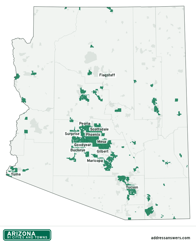
Arizona city limits map image
The map above as a picture: every Arizona city and town in green, with county lines. Boundaries from the Census Bureau, as of January 1, 2025.
You’re welcome to use it in a document or on your own site, with a link back to this page.
Download the map (PNG, 780 × 972)Questions about Arizona city limits
How many cities and towns are in Arizona?
Arizona has 91 incorporated places: 46 cities and 45 towns, by the Census Bureau’s boundary files for 2025.
What is the largest city in Arizona?
By population, Phoenix, with about 1.6 million residents (2020–2024 American Community Survey 5-year estimates). It is also the largest by land area, at 518.4 square miles.
What is the smallest town in Arizona?
By the Census Bureau’s estimate, Winkelman, with 191 residents. Estimates for places this small have a wide margin of error, so treat it as a rough count.
How much of Arizona is unincorporated?
96% of its land and 1.5 million of its residents (20%) are outside every city or town. There, local government is the county. The state also has 376 named unincorporated communities; the largest is San Tan Valley.
Is San Tan Valley, AZ a city?
No. San Tan Valley is a census-designated place: a community the Census Bureau maps for statistics, with no city government of its own. About 109,189 people live there, in unincorporated Pinal County. An address there is outside city limits, even if its mailing address says otherwise.
Is Casas Adobes, AZ a city?
No. Casas Adobes is a census-designated place: a community the Census Bureau maps for statistics, with no city government of its own. About 72,059 people live there, in unincorporated Pima County. An address there is outside city limits, even if its mailing address says otherwise.
Which cities and towns in Arizona are in more than one county?
Five of the 91 cross a county line, by at least 1% of their land. The largest: Peoria (Maricopa and Yavapai), Queen Creek (Maricopa and Pinal), and Sedona (Yavapai and Coconino). Check an address to see which county it’s in.
Which county in Arizona has the most cities and towns?
Maricopa County, with 24 at least partly inside it. Every county in Arizona has at least one.
Bordering states
More answers for a Arizona address
Each tool checks the same address and puts its own answer first.
- County Census Your county, plus the township or town where those exist. Find your county
- School district Census The public school district that covers the address. Find your school district
- Flood zone FEMA The FEMA zone in plain English, and whether lenders require flood insurance. Check flood zone
- USDA home loans USDA Whether the property is in an area eligible for a USDA Rural Development loan. Check USDA eligibility
- Voting districts Census Your congressional district and your state senate and state house districts. Included in every check
Places, boundaries, land area and counties: US Census Bureau 2025 cartographic boundary files (boundaries as of January 1, 2025). A place is listed in each county that holds at least 1% of its land. Population: 2020–2024 American Community Survey 5-year estimates. Data updated October 24, 2026; page updated October 25, 2026. Boundaries change through annexation; your city or county has the official map.