Nevada city limits map
Nevada has 19 incorporated cities. They cover 1.1% of the state’s land and are home to 57% of its residents. Everyone else lives outside city limits, where local government is the county. Enter an address to see which side of a city line it’s on.
Result for
The map couldn’t load. The answers don’t depend on it.
The boundary couldn’t load. The answer doesn’t depend on it.
Census Geocoder match
More about this address
Sources and limits
- Census
- US Census Bureau Geocoder, current boundaries
- FEMA
- National Flood Hazard Layer, effective flood maps
- USDA
- Rural Development property eligibility
- Map
- Boundaries from Census TIGERweb, flood zones drawn by FEMA, eligible areas from USDA, base map © OpenStreetMap contributors
Census boundaries are updated once a year, so a recent annexation may not show yet. Informational only, not an official determination. Verify with your city or county.
Nevada at a glance
- Incorporated places
- 19
- 19 cities
- Residents in city limits
- 57%
- 1,830,139 of 3,184,612
- Land in city limits
- 1.1%
- 1,173 of 109,860 sq mi
- Counties
- 17
- 7 with no city
- Unincorporated communities
- 119
- Largest: Enterprise (240,464)
- Largest city
- Las Vegas
- 660,400 residents
How local government works in Nevada
Carson City is a consolidated municipality: the city and the county are one government. Most of the Las Vegas Strip is in Paradise, an unincorporated community in Clark County, not in the City of Las Vegas.
City limits maps for 5 Nevada cities
Every Nevada city with 100,000 or more residents has its own page: the boundary in detail, the places around it and its school districts.
All 19 cities in Nevada
Every incorporated place, largest first, with the counties it’s in and its size. An address inside one of these is inside city limits; anywhere else in the state is unincorporated.
| Name | County | Population | Land (sq mi) |
|---|---|---|---|
| Las Vegas | Clark | 660,400 | 141.9 |
| Henderson | Clark | 332,141 | 121.0 |
| North Las Vegas | Clark | 278,595 | 105.4 |
| Reno | Washoe | 273,212 | 109.3 |
| Sparks | Washoe | 110,024 | 36.5 |
| Carson City | Independent city | 58,384 | 144.5 |
| Fernley | Lyon | 24,225 | 122.7 |
| Mesquite | Clark | 22,059 | 31.8 |
| Elko | Elko | 20,696 | 17.8 |
| Boulder City | Clark | 14,919 | 212.3 |
| Fallon | Churchill | 9,463 | 3.72 |
| Winnemucca | Humboldt | 8,361 | 9.80 |
| West Wendover | Elko | 4,514 | 7.48 |
| Ely | White Pine | 3,929 | 7.63 |
| Yerington | Lyon | 3,150 | 29.5 |
| Carlin | Elko | 2,088 | 10.4 |
| Lovelock | Pershing | 1,481 | 0.86 |
| Wells | Elko | 1,352 | 6.90 |
| Caliente | Lincoln | 1,146 | 53.0 |
Unincorporated communities in Nevada
Census-designated places: named communities the Census Bureau maps for statistics, with no city government of their own. An address in one is outside city limits, even when its mailing address names a city. Nevada has 119.
| Community | County | Population | Land (sq mi) |
|---|---|---|---|
| Enterprise | Clark | 240,464 | 66.0 |
| Spring Valley | Clark | 219,187 | 35.5 |
| Sunrise Manor | Clark | 200,218 | 33.7 |
| Paradise | Clark | 185,913 | 42.4 |
| Pahrump | Nye | 47,347 | 328.8 |
| Whitney | Clark | 47,221 | 6.81 |
| Winchester | Clark | 37,081 | 4.96 |
| Summerlin South | Clark | 31,354 | 9.69 |
| Sun Valley | Washoe | 22,228 | 14.6 |
| Spanish Springs | Washoe | 17,980 | 55.6 |
| Dayton | Lyon | 15,781 | 34.9 |
| Spring Creek | Elko | 14,739 | 53.7 |
| Gardnerville Ranchos | Douglas | 12,114 | 10.3 |
| Cold Springs | Washoe | 11,321 | 8.76 |
| Incline Village | Washoe | 9,272 | 21.5 |
| Laughlin | Clark | 8,789 | 16.3 |
| Moapa Valley | Clark | 6,684 | 43.7 |
| Johnson Lane | Douglas | 6,467 | 21.9 |
| Indian Hills | Douglas | 5,527 | 14.6 |
| Gardnerville | Douglas | 5,486 | 4.80 |
| Nellis AFB | Clark | 5,087 | 2.74 |
| Silver Springs | Lyon | 5,060 | 71.6 |
| Lemmon Valley | Washoe | 4,412 | 15.9 |
| Minden | Douglas | 3,707 | 3.70 |
| Battle Mountain | Lander | 3,518 | 6.11 |
| Washoe Valley | Washoe | 3,315 | 5.04 |
| Hawthorne | Mineral | 2,809 | 1.76 |
| Kingsbury | Douglas | 2,209 | 21.8 |
| Tonopah | Nye | 1,910 | 9.26 |
| Stagecoach | Lyon | 1,892 | 8.35 |
| Smith Valley | Lyon | 1,807 | 102.0 |
| Sandy Valley | Clark | 1,742 | 56.0 |
| Ruhenstroth | Douglas | 1,682 | 2.83 |
| Topaz Ranch Estates | Douglas | 1,621 | 14.4 |
| Amargosa Valley | Nye | 1,445 | 98.7 |
| Jackpot | Elko | 1,415 | 3.89 |
| Fallon Station | Churchill | 1,399 | 2.84 |
| Osino | Elko | 1,341 | 2.57 |
| Genoa | Douglas | 1,284 | 9.19 |
| East Valley | Douglas | 1,283 | 9.84 |
| Indian Springs | Clark | 1,180 | 18.0 |
| Golden Valley | Washoe | 1,139 | 3.61 |
| Grass Valley | Pershing | 1,134 | 34.5 |
| McGill | White Pine | 1,050 | 1.21 |
| Mogul | Washoe | 1,050 | 1.45 |
| Pioche | Lincoln | 1,031 | 6.15 |
| Panaca | Lincoln | 1,015 | 3.08 |
| Verdi | Washoe | 1,012 | 3.31 |
| Moapa Town | Clark | 958 | 17.9 |
| Round Hill Village | Douglas | 823 | 5.79 |
| Schurz | Mineral | 821 | 11.2 |
| Alamo | Lincoln | 736 | 6.35 |
| Wadsworth | Washoe | 705 | 3.71 |
| Crescent Valley | Eureka | 690 | 2.23 |
| Owyhee | Elko | 647 | 224.4 |
| Virginia City | Storey | 644 | 0.87 |
| Zephyr Cove | Douglas | 562 | 2.12 |
| Fish Springs | Douglas | 528 | 9.19 |
| Carter Springs | Douglas | 526 | 2.80 |
| Stateline | Douglas | 503 | 0.72 |
| Mount Charleston | Clark | 465 | 29.3 |
| Beatty | Nye | 387 | 17.7 |
| Imlay | Pershing | 385 | 1.20 |
| Glenbrook | Douglas | 378 | 3.79 |
| Goldfield | Esmeralda | 376 | 1.48 |
| Walker Lake | Mineral | 376 | 1.26 |
| Bunkerville | Clark | 370 | 10.3 |
| Blue Diamond | Clark | 351 | 7.22 |
| Topaz Lake | Douglas | 318 | 1.24 |
| Skyland | Douglas | 313 | 4.36 |
| Goodsprings | Clark | 311 | 0.98 |
| Nixon | Washoe | 305 | 6.33 |
| Ruth | White Pine | 298 | 0.35 |
| Fort McDermitt | Humboldt | 286 | 18.0 |
| Sutcliffe | Washoe | 282 | 10.0 |
| Eureka | Eureka | 279 | 1.29 |
| Dyer | Esmeralda | 277 | 35.1 |
| Cal-Nev-Ari | Clark | 275 | 2.28 |
| Double Spring | Douglas | 265 | 8.77 |
| Preston | White Pine | 257 | 1.29 |
| Paradise Valley | Humboldt | 247 | 3.42 |
| Searchlight | Clark | 246 | 3.87 |
| Gabbs | Nye | 237 | 1.50 |
| Silver Peak | Esmeralda | 222 | 0.99 |
| Lakeridge | Douglas | 204 | 1.46 |
| Golconda | Humboldt | 203 | 1.69 |
| Kingston | Lander | 144 | 4.07 |
| Orovada | Humboldt | 141 | 22.2 |
| Crystal Bay | Washoe | 131 | 0.45 |
| Lund | White Pine | 122 | 1.97 |
| Humboldt River Ranch | Pershing | 118 | 20.2 |
| Silver City | Lyon | 118 | 0.97 |
| Rachel | Lincoln | 113 | 4.34 |
| Mina | Mineral | 107 | 2.41 |
| Bennett Springs | Lincoln | 101 | 3.39 |
| Montello | Elko | 80 | 0.41 |
| Austin | Lander | 64 | 1.15 |
| Logan Creek | Douglas | 61 | 1.75 |
| Gerlach | Washoe | 58 | 3.13 |
| Denio | Humboldt | 36 | 0.46 |
| Nelson | Clark | 32 | 4.80 |
| Hiko | Lincoln | 23 | 23.4 |
| McDermitt | Humboldt | 22 | 1.57 |
| Mountain City | Elko | 16 | 0.18 |
| Baker | White Pine | 0 | 0.90 |
| Beaverdam | Lincoln | 0 | 0.69 |
| Dry Valley | Lincoln | 0 | 3.79 |
| Empire | Washoe | 0 | 5.13 |
| Lamoille | Elko | 0 | 1.84 |
| Mount Wilson | Lincoln | 0 | 4.61 |
| Unionville | Pershing | 0 | 0.77 |
| Ursine | Lincoln | 0 | 4.34 |
| Valmy | Humboldt | 0 | 0.21 |
| Jarbidge | Elko | – | 0.13 |
| Midas | Elko | – | 0.14 |
| Ryndon | Elko | – | 6.01 |
| South Fork | Elko | – | 7.65 |
| Tuscarora | Elko | – | 0.06 |
| Wildhorse | Elko | – | 3.03 |
Showing 1–50 of 119
Counties in Nevada
17 counties, with how many cities have land in each and the largest whose main county it is.
| County | Cities | Largest | Population | Land (sq mi) |
|---|---|---|---|---|
| Clark County | 5 | Las Vegas | 2,329,548 | 7,892 |
| Washoe County | 2 | Reno | 497,200 | 6,316 |
| Lyon County | 2 | Fernley | 61,680 | 2,003 |
| Carson City | 1 | Carson City | 58,384 | 144.5 |
| Nye County | 0 | None | 54,344 | 18,182 |
| Elko County | 4 | Elko | 54,047 | 17,173 |
| Douglas County | 0 | None | 49,623 | 710.5 |
| Churchill County | 1 | Fallon | 25,805 | 4,950 |
| Humboldt County | 1 | Winnemucca | 17,289 | 9,641 |
| White Pine County | 1 | Ely | 8,735 | 8,887 |
| Pershing County | 1 | Lovelock | 6,487 | 6,037 |
| Lander County | 0 | None | 5,770 | 5,519 |
| Mineral County | 0 | None | 4,542 | 3,751 |
| Lincoln County | 1 | Caliente | 4,405 | 10,633 |
| Storey County | 0 | None | 4,140 | 263.8 |
| Eureka County | 0 | None | 1,585 | 4,176 |
| Esmeralda County | 0 | None | 1,028 | 3,582 |
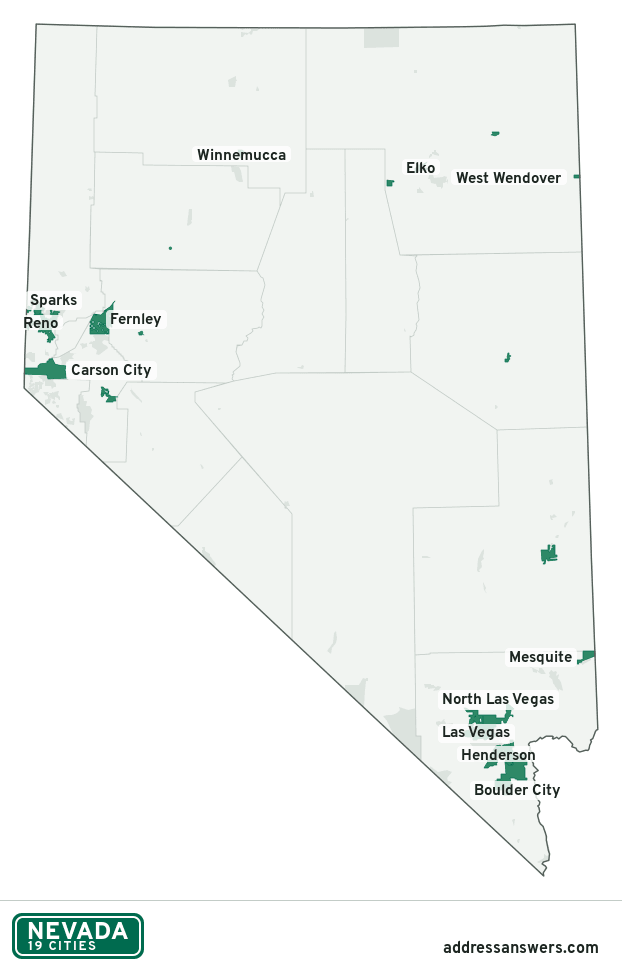
Nevada city limits map image
The map above as a picture: every Nevada city and town in green, with county lines. Boundaries from the Census Bureau, as of January 1, 2025.
You’re welcome to use it in a document or on your own site, with a link back to this page.
Download the map (PNG, 622 × 972)Questions about Nevada city limits
How many cities are in Nevada?
Nevada has 19 incorporated places: 19 cities, by the Census Bureau’s boundary files for 2025.
What is the largest city in Nevada?
By population, Las Vegas, with about 660,400 residents (2020–2024 American Community Survey 5-year estimates). By land area the largest is Boulder City, at 212.3 square miles (Las Vegas: 141.9).
What is the smallest city in Nevada?
By the Census Bureau’s estimate, Caliente, with 1,146 residents. Estimates for places this small have a wide margin of error, so treat it as a rough count.
How much of Nevada is unincorporated?
99% of its land and 1.4 million of its residents (43%) are outside every city. There, local government is the county. The state also has 119 named unincorporated communities; the largest is Enterprise.
Is Enterprise, NV a city?
No. Enterprise is a census-designated place: a community the Census Bureau maps for statistics, with no city government of its own. About 240,464 people live there, in unincorporated Clark County. An address there is outside city limits, even if its mailing address says otherwise.
Is Spring Valley, NV a city?
No. Spring Valley is a census-designated place: a community the Census Bureau maps for statistics, with no city government of its own. About 219,187 people live there, in unincorporated Clark County. An address there is outside city limits, even if its mailing address says otherwise.
Which county in Nevada has the most cities?
Clark County, with 5 at least partly inside it. Seven counties have none.
Bordering states
More answers for a Nevada address
Each tool checks the same address and puts its own answer first.
- County Census Your county, plus the township or town where those exist. Find your county
- School district Census The public school district that covers the address. Find your school district
- Flood zone FEMA The FEMA zone in plain English, and whether lenders require flood insurance. Check flood zone
- USDA home loans USDA Whether the property is in an area eligible for a USDA Rural Development loan. Check USDA eligibility
- Voting districts Census Your congressional district and your state senate and state house districts. Included in every check
Places, boundaries, land area and counties: US Census Bureau 2025 cartographic boundary files (boundaries as of January 1, 2025). A place is listed in each county that holds at least 1% of its land. Population: 2020–2024 American Community Survey 5-year estimates. Data updated October 24, 2026; page updated October 25, 2026. Boundaries change through annexation; your city or county has the official map.