Oregon city limits map
Oregon has 241 incorporated places: 232 cities and 9 towns. They cover 1.1% of the state’s land and are home to 71% of its residents. Everyone else lives outside city limits, where local government is the county. Enter an address to see which side of a city line it’s on.
Result for
The map couldn’t load. The answers don’t depend on it.
The boundary couldn’t load. The answer doesn’t depend on it.
Census Geocoder match
More about this address
Sources and limits
- Census
- US Census Bureau Geocoder, current boundaries
- FEMA
- National Flood Hazard Layer, effective flood maps
- USDA
- Rural Development property eligibility
- Map
- Boundaries from Census TIGERweb, flood zones drawn by FEMA, eligible areas from USDA, base map © OpenStreetMap contributors
Census boundaries are updated once a year, so a recent annexation may not show yet. Informational only, not an official determination. Verify with your city or county.
Oregon at a glance
- Incorporated places
- 241
- 232 cities and 9 towns
- Residents in city limits
- 71%
- 3,018,216 of 4,254,293
- Land in city limits
- 1.1%
- 1,012 of 95,997 sq mi
- Counties
- 36
- Every one has at least one
- Unincorporated communities
- 185
- Largest: Aloha (52,389)
- Largest city
- Portland
- 641,165 residents
City limits maps for 6 Oregon cities
Every Oregon city with 100,000 or more residents has its own page: the boundary in detail, the places around it and its school districts.
All 241 cities in Oregon
Every incorporated place, largest first, with the counties it’s in and its size. An address inside one of these is inside city limits; anywhere else in the state is unincorporated.
| Name | Type | County | Population | Land (sq mi) |
|---|---|---|---|---|
| Portland | City | Multnomah | 641,165 | 133.5 |
| Eugene | City | Lane | 179,591 | 44.7 |
| Salem | City | Marion, Polk | 178,865 | 49.0 |
| Gresham | City | Multnomah | 112,378 | 23.6 |
| Hillsboro | City | Washington | 108,231 | 26.4 |
| Bend | City | Deschutes | 103,390 | 35.2 |
| Beaverton | City | Washington | 97,812 | 19.8 |
| Medford | City | Jackson | 86,315 | 28.7 |
| Springfield | City | Lane | 61,499 | 16.1 |
| Corvallis | City | Benton | 59,960 | 14.5 |
| Albany | City | Linn, Benton | 56,839 | 17.9 |
| Tigard | City | Washington | 56,011 | 12.8 |
| Lake Oswego | City | Clackamas, Multnomah | 40,381 | 10.9 |
| Grants Pass | City | Josephine | 39,311 | 11.5 |
| Keizer | City | Marion | 39,082 | 7.19 |
| Oregon City | City | Clackamas | 37,755 | 10.1 |
| Redmond | City | Deschutes | 36,092 | 18.8 |
| McMinnville | City | Yamhill | 34,596 | 10.6 |
| Woodburn | City | Marion | 27,875 | 6.18 |
| Tualatin | City | Washington, Clackamas | 27,763 | 8.42 |
| Wilsonville | City | Clackamas, Washington | 26,974 | 7.69 |
| West Linn | City | Clackamas | 26,935 | 7.43 |
| Happy Valley | City | Clackamas | 26,738 | 11.9 |
| Forest Grove | City | Washington | 26,529 | 5.99 |
| Newberg | City | Yamhill | 26,066 | 5.98 |
| Roseburg | City | Douglas | 23,778 | 10.8 |
| Klamath Falls | City | Klamath | 22,115 | 20.1 |
| Milwaukie | City | Clackamas | 21,392 | 4.99 |
| Ashland | City | Jackson | 21,259 | 6.67 |
| Sherwood | City | Washington | 20,307 | 4.93 |
| Hermiston | City | Umatilla | 19,546 | 8.64 |
| Lebanon | City | Linn | 19,344 | 7.17 |
| Central Point | City | Jackson | 19,216 | 4.05 |
| Canby | City | Clackamas | 18,134 | 4.77 |
| Dallas | City | Polk | 17,531 | 4.94 |
| Pendleton | City | Umatilla | 16,950 | 11.6 |
| Coos Bay | City | Coos | 15,925 | 10.6 |
| Troutdale | City | Multnomah | 15,923 | 5.95 |
| The Dalles | City | Wasco | 15,917 | 6.69 |
| St. Helens | City | Columbia | 14,258 | 4.88 |
| Cornelius | City | Washington | 14,255 | 2.34 |
| La Grande | City | Union | 13,058 | 4.64 |
| Sandy | City | Clackamas | 12,854 | 3.69 |
| Gladstone | City | Clackamas | 11,977 | 2.40 |
| Ontario | City | Malheur | 11,842 | 5.98 |
| Prineville | City | Crook | 11,470 | 12.8 |
| Monmouth | City | Polk | 11,428 | 2.24 |
| Fairview | City | Multnomah | 10,735 | 3.09 |
| Cottage Grove | City | Lane | 10,698 | 3.88 |
| Newport | City | Lincoln | 10,583 | 9.98 |
| Silverton | City | Marion | 10,456 | 3.51 |
| Baker City | City | Baker | 10,210 | 7.21 |
| Independence | City | Polk | 10,199 | 3.01 |
| Molalla | City | Clackamas | 10,186 | 2.51 |
| North Bend | City | Coos | 10,171 | 3.93 |
| Astoria | City | Clatsop | 10,109 | 6.11 |
| Sweet Home | City | Linn | 10,078 | 5.31 |
| Lincoln City | City | Lincoln | 9,968 | 6.05 |
| Eagle Point | City | Jackson | 9,839 | 2.97 |
| Florence | City | Lane | 9,482 | 5.55 |
| Sutherlin | City | Douglas | 8,599 | 6.11 |
| Hood River | City | Hood River | 8,361 | 2.62 |
| Stayton | City | Marion | 8,292 | 3.12 |
| Scappoose | City | Columbia | 8,179 | 3.44 |
| Madras | City | Jefferson | 7,676 | 8.16 |
| Umatilla | City | Umatilla | 7,508 | 5.09 |
| Seaside | City | Clatsop | 7,192 | 4.05 |
| Milton-Freewater | City | Umatilla | 7,036 | 2.03 |
| Junction City | City | Lane | 6,947 | 3.32 |
| Brookings | City | Curry | 6,703 | 4.15 |
| Sheridan | City | Yamhill | 6,339 | 2.11 |
| Warrenton | City | Clatsop | 6,327 | 12.7 |
| Talent | City | Jackson | 6,254 | 1.34 |
| Winston | City | Douglas | 5,690 | 2.76 |
| Philomath | City | Benton | 5,642 | 2.07 |
| Creswell | City | Lane | 5,621 | 1.72 |
| Tillamook | City | Tillamook | 5,218 | 1.90 |
| Veneta | City | Lane | 5,200 | 2.57 |
| Estacada | City | Clackamas | 5,152 | 2.65 |
| King City | City | Washington | 5,073 | 0.81 |
| Wood Village | City | Multnomah | 4,696 | 0.94 |
| Lafayette | City | Yamhill | 4,490 | 0.93 |
| Phoenix | City | Jackson | 4,390 | 1.91 |
| Reedsport | City | Douglas | 4,317 | 2.07 |
| Aumsville | City | Marion | 4,230 | 1.13 |
| Boardman | City | Morrow | 4,064 | 4.03 |
| Coquille | City | Coos | 4,002 | 2.76 |
| Harrisburg | City | Linn | 3,681 | 1.44 |
| Toledo | City | Lincoln | 3,546 | 2.22 |
| Myrtle Creek | City | Douglas | 3,500 | 2.50 |
| North Plains | City | Washington | 3,433 | 1.09 |
| Hubbard | City | Marion | 3,406 | 0.80 |
| Mount Angel | City | Marion | 3,393 | 1.14 |
| Millersburg | City | Linn | 3,366 | 4.14 |
| Bandon | City | Coos | 3,330 | 2.76 |
| Jefferson | City | Marion | 3,301 | 0.86 |
| Lakeview | Town | Lake | 3,270 | 2.50 |
| Nyssa | City | Malheur | 3,240 | 1.55 |
| Dundee | City | Yamhill | 3,213 | 1.34 |
| Oakridge | City | Lane | 3,184 | 2.16 |
| Shady Cove | City | Jackson | 3,076 | 1.95 |
| Sisters | City | Deschutes | 3,022 | 1.93 |
| Jacksonville | City | Jackson | 2,991 | 1.89 |
| Sublimity | City | Marion | 2,919 | 0.94 |
| Turner | City | Marion | 2,792 | 1.43 |
| Vernonia | City | Columbia | 2,786 | 1.60 |
| Carlton | City | Yamhill | 2,759 | 0.88 |
| Burns | City | Harney | 2,723 | 3.55 |
| Myrtle Point | City | Coos | 2,684 | 1.61 |
| Dayton | City | Yamhill | 2,675 | 0.84 |
| Gervais | City | Marion | 2,581 | 0.41 |
| La Pine | City | Deschutes | 2,547 | 7.14 |
| Gold Beach | City | Curry | 2,466 | 2.70 |
| Clatskanie | City | Columbia | 2,364 | 1.30 |
| Vale | City | Malheur | 2,348 | 1.17 |
| Union | City | Union | 2,290 | 2.49 |
| Culver | City | Jefferson | 2,254 | 0.70 |
| Rogue River | City | Jackson | 2,238 | 0.98 |
| Willamina | City | Yamhill, Polk | 2,193 | 0.95 |
| Waldport | City | Lincoln | 2,177 | 3.08 |
| Banks | City | Washington | 2,156 | 0.76 |
| Enterprise | City | Wallowa | 2,131 | 1.47 |
| Rainier | City | Columbia | 2,130 | 4.08 |
| Irrigon | City | Morrow | 2,120 | 1.30 |
| Amity | City | Yamhill | 2,089 | 0.59 |
| Columbia City | City | Columbia | 2,006 | 0.78 |
| Durham | City | Washington | 1,983 | 0.41 |
| Gearhart | City | Clatsop | 1,978 | 1.87 |
| Canyonville | City | Douglas | 1,920 | 1.06 |
| Mill City | City | Linn, Marion | 1,920 | 0.90 |
| Brownsville | City | Linn | 1,912 | 1.34 |
| Stanfield | City | Umatilla | 1,902 | 1.73 |
| Bay City | City | Tillamook | 1,875 | 1.28 |
| Lakeside | City | Coos | 1,870 | 2.00 |
| Depoe Bay | City | Lincoln | 1,782 | 1.81 |
| Cave Junction | City | Josephine | 1,691 | 1.80 |
| Coburg | City | Lane | 1,626 | 1.20 |
| John Day | City | Grant | 1,609 | 2.26 |
| Hines | City | Harney | 1,604 | 2.06 |
| Rockaway Beach | City | Tillamook | 1,562 | 1.60 |
| Elgin | City | Union | 1,549 | 1.01 |
| Halsey | City | Linn | 1,491 | 0.56 |
| Cascade Locks | City | Hood River | 1,378 | 2.08 |
| Athena | City | Umatilla | 1,377 | 0.58 |
| Cannon Beach | City | Clatsop | 1,361 | 1.56 |
| Dunes City | City | Lane | 1,357 | 2.69 |
| Tangent | City | Linn | 1,290 | 3.78 |
| Gold Hill | City | Jackson | 1,288 | 0.76 |
| Pilot Rock | City | Umatilla | 1,283 | 1.48 |
| Heppner | City | Morrow | 1,277 | 1.23 |
| Yamhill | City | Yamhill | 1,273 | 0.49 |
| Adair Village | City | Benton | 1,233 | 0.44 |
| Lowell | City | Lane | 1,228 | 0.87 |
| Falls City | City | Polk | 1,222 | 1.20 |
| Island City | City | Union | 1,145 | 0.98 |
| Lyons | City | Linn | 1,139 | 0.92 |
| Metolius | City | Jefferson | 1,137 | 0.48 |
| Donald | City | Marion | 1,133 | 0.38 |
| Siletz | City | Lincoln | 1,119 | 0.63 |
| Monroe | City | Benton | 1,102 | 0.51 |
| Drain | City | Douglas | 1,078 | 0.63 |
| Joseph | City | Wallowa | 1,054 | 0.91 |
| Oakland | City | Douglas | 1,048 | 0.73 |
| Aurora | City | Marion | 1,030 | 0.48 |
| Maywood Park | City | Multnomah | 987 | 0.17 |
| Port Orford | City | Curry | 986 | 1.57 |
| Glendale | City | Douglas | 981 | 0.39 |
| Yachats | City | Lincoln | 979 | 0.91 |
| Yoncalla | City | Douglas | 971 | 0.67 |
| Riddle | City | Douglas | 955 | 0.63 |
| Dufur | City | Wasco | 952 | 0.59 |
| Scio | City | Linn | 930 | 0.44 |
| Canyon City | Town | Grant | 900 | 1.41 |
| Merrill | City | Klamath | 819 | 0.48 |
| Malin | City | Klamath | 799 | 0.50 |
| Garibaldi | City | Tillamook | 796 | 0.99 |
| Huntington | City | Baker | 739 | 0.74 |
| Mosier | City | Wasco | 714 | 0.46 |
| Arlington | City | Gilliam | 690 | 2.76 |
| Rivergrove | City | Clackamas, Washington | 657 | 0.17 |
| Cove | City | Union | 651 | 0.80 |
| Wallowa | City | Wallowa | 633 | 0.62 |
| Bonanza | Town | Klamath | 632 | 0.82 |
| Condon | City | Gilliam | 623 | 0.81 |
| Prairie City | City | Grant | 615 | 0.99 |
| Powers | City | Coos | 613 | 0.58 |
| Gaston | City | Washington, Yamhill | 605 | 0.34 |
| Manzanita | City | Tillamook | 568 | 0.82 |
| North Powder | City | Union | 563 | 0.63 |
| Fossil | City | Wheeler | 535 | 0.78 |
| Johnson City | City | Clackamas | 499 | 0.06 |
| Echo | City | Umatilla | 494 | 0.83 |
| Helix | City | Umatilla | 471 | 0.13 |
| St. Paul | City | Marion | 469 | 0.29 |
| Chiloquin | City | Klamath | 465 | 0.82 |
| Maupin | City | Wasco | 465 | 1.39 |
| Ione | City | Morrow | 456 | 0.76 |
| Wasco | City | Sherman | 455 | 1.01 |
| Gates | City | Marion, Linn | 452 | 0.65 |
| Wheeler | City | Tillamook | 448 | 0.52 |
| Weston | City | Umatilla | 443 | 0.56 |
| Moro | City | Sherman | 392 | 0.50 |
| Butte Falls | Town | Jackson | 364 | 0.43 |
| Mount Vernon | City | Grant | 364 | 0.68 |
| Scotts Mills | City | Marion | 337 | 0.36 |
| Halfway | City | Baker | 312 | 0.37 |
| Sodaville | City | Linn | 309 | 0.31 |
| Adrian | City | Malheur | 299 | 0.24 |
| Adams | City | Umatilla | 292 | 0.36 |
| Grass Valley | City | Sherman | 261 | 0.51 |
| Lostine | City | Wallowa | 255 | 0.29 |
| Westfir | City | Lane | 253 | 0.31 |
| Paisley | City | Lake | 249 | 0.42 |
| Nehalem | City | Tillamook | 235 | 0.27 |
| Waterloo | Town | Linn | 229 | 0.12 |
| Rufus | City | Sherman | 212 | 1.18 |
| Haines | City | Baker | 209 | 0.76 |
| Dayville | Town | Grant | 206 | 0.53 |
| Idanha | City | Marion, Linn | 201 | 0.74 |
| Long Creek | City | Grant | 200 | 1.02 |
| Richland | City | Baker | 197 | 0.11 |
| Sumpter | City | Baker | 197 | 2.18 |
| Imbler | City | Union | 189 | 0.22 |
| Monument | City | Grant | 185 | 0.51 |
| Jordan Valley | City | Malheur | 180 | 2.08 |
| Ukiah | City | Umatilla | 177 | 0.22 |
| Elkton | City | Douglas | 150 | 0.23 |
| Mitchell | City | Wheeler | 127 | 1.28 |
| Detroit | City | Marion | 111 | 0.59 |
| Seneca | City | Grant | 109 | 0.79 |
| Summerville | Town | Union | 106 | 0.26 |
| Barlow | City | Clackamas | 105 | 0.05 |
| Granite | City | Grant | 93 | 0.37 |
| Spray | Town | Wheeler | 89 | 0.29 |
| Lexington | Town | Morrow | 83 | 0.44 |
| Antelope | City | Wasco | 68 | 0.46 |
| Lonerock | City | Gilliam | 36 | 1.03 |
| Prescott | City | Columbia | 34 | 0.07 |
| Unity | City | Baker | 27 | 0.64 |
| Shaniko | City | Wasco | 14 | 0.50 |
| Greenhorn | City | Baker, Grant | 0 | 0.09 |
Showing 1–50 of 241
Unincorporated communities in Oregon
Census-designated places: named communities the Census Bureau maps for statistics, with no city government of their own. An address in one is outside city limits, even when its mailing address names a city. Oregon has 185.
| Community | County | Population | Land (sq mi) |
|---|---|---|---|
| Aloha | Washington | 52,389 | 7.30 |
| Bethany | Washington | 33,106 | 5.44 |
| Hayesville | Marion | 21,246 | 2.99 |
| Altamont | Klamath | 19,927 | 8.06 |
| Cedar Mill | Washington | 19,471 | 3.33 |
| Oak Grove | Clackamas | 16,796 | 3.90 |
| Four Corners | Marion | 16,275 | 2.43 |
| Oatfield | Clackamas | 13,294 | 3.40 |
| Damascus | Clackamas | 11,437 | 17.4 |
| Oak Hills | Washington | 11,131 | 1.55 |
| White City | Jackson | 10,750 | 1.87 |
| Santa Clara | Lane | 10,551 | 4.67 |
| Bull Mountain | Washington | 9,865 | 1.98 |
| Rockcreek | Washington | 9,223 | 1.97 |
| River Road | Lane | 8,862 | 1.80 |
| Cedar Hills | Washington | 8,388 | 1.87 |
| Jennings Lodge | Clackamas | 7,971 | 1.59 |
| West Haven-Sylvan | Washington | 7,674 | 2.24 |
| Green | Douglas | 7,541 | 4.56 |
| Garden Home-Whitford | Washington | 6,979 | 1.55 |
| Raleigh Hills | Washington | 6,744 | 1.52 |
| West Slope | Washington | 6,582 | 1.61 |
| Deschutes River Woods | Deschutes | 5,797 | 6.08 |
| Marlene Village | Washington | 5,439 | 0.90 |
| Crooked River Ranch | Jefferson | 5,160 | 20.7 |
| Beavercreek | Clackamas | 4,894 | 20.1 |
| Mount Hood Villages | Clackamas | 4,703 | 22.4 |
| Roseburg North | Douglas | 4,601 | 1.81 |
| Tri-City | Douglas | 4,234 | 7.27 |
| Three Rivers | Deschutes | 3,995 | 7.53 |
| Redwood | Josephine | 3,721 | 3.46 |
| Metzger | Washington | 3,714 | 0.75 |
| Eagle Crest | Deschutes | 2,677 | 15.2 |
| Juniper Canyon | Crook | 2,666 | 94.1 |
| Heceta Beach | Lane | 2,651 | 2.32 |
| Warm Springs | Jefferson | 2,480 | 42.4 |
| Harbor | Curry | 2,437 | 1.92 |
| Lincoln Beach | Lincoln | 2,434 | 3.23 |
| Mulino | Clackamas | 2,229 | 13.8 |
| Odell | Hood River | 2,218 | 2.02 |
| Dunthorpe | Multnomah | 1,875 | 1.05 |
| Boring | Clackamas | 1,869 | 4.31 |
| Glide | Douglas | 1,823 | 10.1 |
| Barview | Coos | 1,684 | 1.38 |
| Keno | Klamath | 1,651 | 9.25 |
| Warren | Columbia | 1,637 | 6.31 |
| Bunker Hill | Coos | 1,626 | 1.46 |
| Merlin | Josephine | 1,617 | 4.15 |
| Terrebonne | Deschutes | 1,602 | 1.02 |
| Stafford | Clackamas | 1,600 | 6.27 |
| Grand Ronde | Polk | 1,549 | 19.2 |
| Prineville Lake Acres | Crook | 1,497 | 6.59 |
| Sunriver | Deschutes | 1,488 | 8.85 |
| Chenoweth | Wasco | 1,445 | 5.62 |
| Rose Lodge | Lincoln | 1,381 | 9.59 |
| Saunders Lake | Coos | 1,338 | 2.86 |
| Pacific City | Tillamook | 1,303 | 3.72 |
| New Hope | Josephine | 1,296 | 3.83 |
| Umapine | Umatilla | 1,215 | 3.32 |
| Ruch | Jackson | 1,151 | 6.73 |
| Bayside Gardens | Tillamook | 1,128 | 0.99 |
| Foots Creek | Jackson | 1,110 | 6.07 |
| Netarts | Tillamook | 1,022 | 2.60 |
| Melrose | Douglas | 964 | 4.35 |
| Lookingglass | Douglas | 963 | 11.6 |
| South Lebanon | Linn | 939 | 1.17 |
| Bayshore | Lincoln | 925 | 1.38 |
| Mission | Umatilla | 878 | 7.61 |
| Neotsu | Lincoln | 872 | 1.07 |
| Dexter | Lane | 865 | 1.84 |
| Falcon Heights | Klamath | 837 | 0.42 |
| Knappa | Clatsop | 806 | 2.07 |
| Svensen | Clatsop | 784 | 2.24 |
| Trail | Jackson | 769 | 6.80 |
| Tetherow | Deschutes | 765 | 2.13 |
| Williams | Josephine | 760 | 11.3 |
| Prospect | Jackson | 723 | 3.50 |
| Glasgow | Coos | 697 | 3.22 |
| Lacomb | Linn | 691 | 3.98 |
| Brooks | Marion | 664 | 0.51 |
| Tumalo | Deschutes | 662 | 1.71 |
| Takilma | Josephine | 658 | 5.94 |
| Running Y Ranch | Klamath | 607 | 4.75 |
| Crabtree | Linn | 602 | 1.82 |
| Crawfordsville | Linn | 588 | 1.92 |
| Green Meadows | Umatilla | 584 | 1.23 |
| Pine Hollow | Wasco | 561 | 2.22 |
| Fairview | Tillamook | 526 | 0.45 |
| Selma | Josephine | 520 | 6.46 |
| San Marine | Lincoln | 506 | 1.13 |
| Mapleton | Lane | 503 | 0.90 |
| Dillard | Douglas | 500 | 1.18 |
| Jasper | Lane | 493 | 2.66 |
| Pleasant Valley | Tillamook | 486 | 2.93 |
| Orient | Multnomah | 481 | 0.95 |
| Rocky Point | Klamath | 478 | 1.84 |
| River Point | Clatsop | 475 | 0.52 |
| Nesika Beach | Curry | 465 | 2.28 |
| Oceanside | Tillamook | 430 | 1.04 |
| Oregon Shores | Klamath | 428 | 1.10 |
| Mehama | Marion | 425 | 0.46 |
| Wimer | Jackson | 421 | 4.96 |
| Marcola | Lane | 407 | 1.22 |
| Trent | Lane | 407 | 1.58 |
| Gopher Flats | Umatilla | 382 | 2.11 |
| O'Brien | Josephine | 379 | 5.22 |
| Tutuilla | Umatilla | 365 | 20.0 |
| Crescent | Klamath | 363 | 1.17 |
| Riverside | Umatilla | 362 | 0.61 |
| Annex | Malheur | 340 | 2.46 |
| Cherry Grove | Washington | 335 | 1.08 |
| Seventh Mountain | Deschutes | 335 | 1.93 |
| Elmira | Lane | 319 | 1.23 |
| Ochoco West | Crook | 319 | 0.44 |
| Parkdale | Hood River | 319 | 0.63 |
| Hebo | Tillamook | 311 | 1.63 |
| Camp Sherman | Jefferson | 298 | 3.15 |
| Cheshire | Lane | 296 | 0.47 |
| Gilchrist | Klamath | 291 | 0.38 |
| Neskowin | Tillamook | 290 | 1.39 |
| Langlois | Curry | 286 | 1.43 |
| Beaver | Tillamook | 276 | 0.39 |
| Days Creek | Douglas | 270 | 2.36 |
| Westport | Clatsop | 263 | 0.66 |
| Kirkpatrick | Umatilla | 258 | 3.58 |
| Pronghorn | Deschutes | 257 | 6.58 |
| Alpine | Benton | 240 | 0.86 |
| Labish Village | Marion | 238 | 0.05 |
| Jeffers Gardens | Clatsop | 235 | 0.57 |
| Fair Oaks | Douglas | 233 | 1.84 |
| Butteville | Marion | 226 | 1.05 |
| Cape Meares | Tillamook | 225 | 3.44 |
| Harper | Malheur | 219 | 7.00 |
| Neahkahnie | Tillamook | 219 | 0.65 |
| Rhododendron | Clackamas | 214 | 3.91 |
| Holley | Linn | 211 | 2.82 |
| Barnesdale | Tillamook | 208 | 0.75 |
| Pine Grove | Wasco | 208 | 6.03 |
| Silver Lake | Lake | 206 | 1.48 |
| Wedderburn | Curry | 206 | 1.06 |
| Alsea | Benton | 201 | 0.16 |
| Dilley | Washington | 200 | 0.75 |
| Deer Island | Columbia | 199 | 0.49 |
| Gardiner | Douglas | 199 | 0.58 |
| Mount Hood | Hood River | 191 | 1.92 |
| Winchester Bay | Douglas | 191 | 2.65 |
| Kerby | Josephine | 187 | 2.58 |
| Rowena | Wasco | 181 | 1.81 |
| Fort Klamath | Klamath | 155 | 0.24 |
| Crescent Lake | Klamath | 154 | 1.54 |
| Marion | Marion | 154 | 1.15 |
| Bly | Klamath | 150 | 0.85 |
| Government Camp | Clackamas | 147 | 0.75 |
| Cloverdale | Tillamook | 143 | 0.80 |
| Cascadia | Linn | 136 | 5.02 |
| Crane | Harney | 136 | 10.4 |
| Summit | Benton | 134 | 0.32 |
| Idaville | Tillamook | 132 | 0.49 |
| Peoria | Linn | 130 | 0.48 |
| New Pine Creek | Lake | 125 | 2.48 |
| Fort Hill | Polk | 123 | 1.43 |
| Tygh Valley | Wasco | 118 | 3.73 |
| Wamic | Wasco | 117 | 1.21 |
| Black Butte Ranch | Deschutes | 115 | 8.20 |
| Wallowa Lake | Wallowa | 105 | 1.83 |
| Beatty | Klamath | 97 | 0.97 |
| Beaver Marsh | Klamath | 96 | 0.33 |
| Shedd | Linn | 78 | 1.51 |
| McKay | Umatilla | 74 | 23.4 |
| Sportsmans Park | Wasco | 67 | 0.15 |
| Bellfountain | Benton | 66 | 1.35 |
| Plush | Lake | 59 | 1.62 |
| Rickreall | Polk | 52 | 0.17 |
| Cayuse | Umatilla | 44 | 2.88 |
| Brogan | Malheur | 38 | 2.86 |
| West Scio | Linn | 38 | 0.34 |
| Meacham | Umatilla | 32 | 2.27 |
| Chemult | Klamath | 21 | 0.26 |
| Juntura | Malheur | 18 | 2.29 |
| Kings Valley | Benton | 17 | 0.73 |
| Biggs Junction | Sherman | 0 | 0.89 |
| Blodgett | Benton | 0 | 0.56 |
| Eola | Polk | 0 | 0.06 |
| Pistol River | Curry | 0 | 0.59 |
| Sprague River | Klamath | 0 | 0.47 |
Showing 1–50 of 185
Counties in Oregon
36 counties, with how many cities have land in each and the largest whose main county it is.
| County | Cities | Largest | Population | Land (sq mi) |
|---|---|---|---|---|
| Multnomah County | 7 | Portland | 801,477 | 431.0 |
| Washington County | 14 | Hillsboro | 603,947 | 724.3 |
| Clackamas County | 15 | Lake Oswego | 423,975 | 1,871 |
| Lane County | 12 | Eugene | 384,207 | 4,554 |
| Marion County | 20 | Salem | 349,244 | 1,181 |
| Jackson County | 11 | Medford | 222,645 | 2,783 |
| Deschutes County | 4 | Bend | 206,334 | 3,018 |
| Linn County | 15 | Albany | 130,706 | 2,290 |
| Douglas County | 12 | Roseburg | 112,072 | 5,036 |
| Yamhill County | 11 | McMinnville | 108,734 | 715.9 |
| Benton County | 5 | Corvallis | 96,303 | 675.2 |
| Polk County | 6 | Dallas | 89,662 | 740.9 |
| Josephine County | 2 | Grants Pass | 88,179 | 1,639 |
| Umatilla County | 12 | Hermiston | 79,940 | 3,215 |
| Klamath County | 5 | Klamath Falls | 70,247 | 5,950 |
| Coos County | 7 | Coos Bay | 64,827 | 1,596 |
| Columbia County | 7 | St. Helens | 53,493 | 658.7 |
| Lincoln County | 7 | Newport | 50,964 | 981.0 |
| Clatsop County | 5 | Astoria | 41,363 | 828.2 |
| Malheur County | 5 | Ontario | 31,954 | 9,888 |
| Tillamook County | 7 | Tillamook | 27,496 | 1,103 |
| Wasco County | 6 | The Dalles | 26,552 | 2,381 |
| Crook County | 1 | Prineville | 26,277 | 2,979 |
| Union County | 8 | La Grande | 26,144 | 2,037 |
| Jefferson County | 3 | Madras | 25,203 | 1,782 |
| Hood River County | 2 | Hood River | 23,905 | 522.2 |
| Curry County | 3 | Brookings | 23,381 | 1,628 |
| Baker County | 8 | Baker City | 16,840 | 3,068 |
| Morrow County | 5 | Boardman | 12,300 | 2,031 |
| Lake County | 2 | Lakeview | 8,267 | 8,139 |
| Wallowa County | 4 | Enterprise | 7,553 | 3,146 |
| Harney County | 2 | Burns | 7,499 | 10,135 |
| Grant County | 10 | John Day | 7,209 | 4,528 |
| Gilliam County | 3 | Arlington | 1,971 | 1,205 |
| Sherman County | 4 | Wasco | 1,938 | 823.6 |
| Wheeler County | 3 | Fossil | 1,485 | 1,716 |
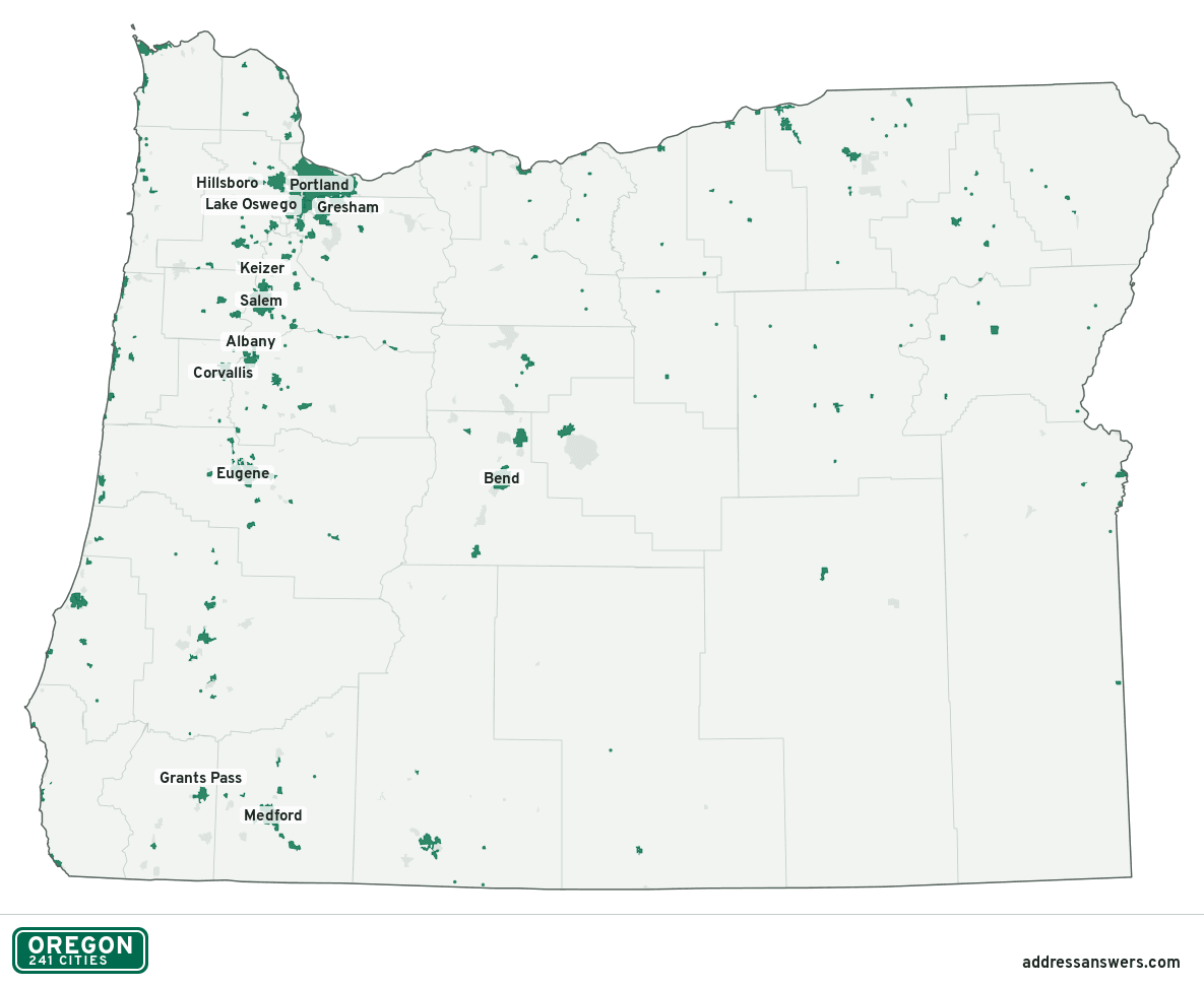
Oregon city limits map image
The map above as a picture: every Oregon city and town in green, with county lines. Boundaries from the Census Bureau, as of January 1, 2025.
You’re welcome to use it in a document or on your own site, with a link back to this page.
Download the map (PNG, 1,185 × 972)Questions about Oregon city limits
How many cities are in Oregon?
Oregon has 241 incorporated places: 232 cities and 9 towns, by the Census Bureau’s boundary files for 2025.
What is the largest city in Oregon?
By population, Portland, with about 641,165 residents (2020–2024 American Community Survey 5-year estimates). It is also the largest by land area, at 133.5 square miles.
What is the smallest city in Oregon?
By the Census Bureau’s estimate, Shaniko, with 14 residents. Estimates for places this small have a wide margin of error, so treat it as a rough count.
How much of Oregon is unincorporated?
99% of its land and 1.2 million of its residents (29%) are outside every city. There, local government is the county. The state also has 185 named unincorporated communities; the largest is Aloha.
Is Aloha, OR a city?
No. Aloha is a census-designated place: a community the Census Bureau maps for statistics, with no city government of its own. About 52,389 people live there, in unincorporated Washington County. An address there is outside city limits, even if its mailing address says otherwise.
Is Bethany, OR a city?
No. Bethany is a census-designated place: a community the Census Bureau maps for statistics, with no city government of its own. About 33,106 people live there, in unincorporated Washington County. An address there is outside city limits, even if its mailing address says otherwise.
Which cities in Oregon are in more than one county?
12 of the 241 cross a county line, by at least 1% of their land. The largest: Salem (Marion and Polk), Albany (Linn and Benton), and Lake Oswego (Clackamas and Multnomah). Check an address to see which county it’s in.
Which county in Oregon has the most cities?
Marion County, with 20 at least partly inside it. Every county in Oregon has at least one.
Bordering states
More answers for a Oregon address
Each tool checks the same address and puts its own answer first.
- County Census Your county, plus the township or town where those exist. Find your county
- School district Census The public school district that covers the address. Find your school district
- Flood zone FEMA The FEMA zone in plain English, and whether lenders require flood insurance. Check flood zone
- USDA home loans USDA Whether the property is in an area eligible for a USDA Rural Development loan. Check USDA eligibility
- Voting districts Census Your congressional district and your state senate and state house districts. Included in every check
Places, boundaries, land area and counties: US Census Bureau 2025 cartographic boundary files (boundaries as of January 1, 2025). A place is listed in each county that holds at least 1% of its land. Population: 2020–2024 American Community Survey 5-year estimates. Data updated October 24, 2026; page updated October 25, 2026. Boundaries change through annexation; your city or county has the official map.