New York city limits map
New York has 594 incorporated places: 62 cities and 532 villages. They cover 4% of the state’s land and are home to 64% of its residents. Everyone else lives outside city limits, where local government is the town and the county. Enter an address to see which side of a city line it’s on.
Result for
The map couldn’t load. The answers don’t depend on it.
The boundary couldn’t load. The answer doesn’t depend on it.
Census Geocoder match
More about this address
Sources and limits
- Census
- US Census Bureau Geocoder, current boundaries
- FEMA
- National Flood Hazard Layer, effective flood maps
- USDA
- Rural Development property eligibility
- Map
- Boundaries from Census TIGERweb, flood zones drawn by FEMA, eligible areas from USDA, base map © OpenStreetMap contributors
Census boundaries are updated once a year, so a recent annexation may not show yet. Informational only, not an official determination. Verify with your city or county.
New York at a glance
- Incorporated places
- 594
- 62 cities and 532 villages
- Residents in city limits
- 64%
- 12,705,120 of 19,852,366
- Land in city limits
- 4%
- 1,879 of 47,124 sq mi
- Counties
- 62
- Every one has at least one
- Unincorporated communities
- 699
- Largest: Cheektowaga (76,056)
- Largest city
- New York City
- 8.5 million residents
How local government works in New York
New York is divided into cities and 933 towns, and its 532 villages sit inside towns. An address outside a city or village is still in a town, which provides local government there, but it isn’t inside city or village limits.
City limits maps for 6 New York cities
Every New York city with 100,000 or more residents has its own page: the boundary in detail, the places around it and its school districts.
All 594 cities and villages in New York
Every incorporated place, largest first, with the counties it’s in and its size. An address inside one of these is inside city limits; anywhere else in the state is unincorporated.
| Name | Type | County | Population | Land (sq mi) |
|---|---|---|---|---|
| New York | City | Queens, Kings +3 | 8,483,844 | 300.5 |
| Buffalo | City | Erie | 276,854 | 40.4 |
| Yonkers | City | Westchester | 209,978 | 18.0 |
| Rochester | City | Monroe | 208,772 | 35.8 |
| Syracuse | City | Onondaga | 146,384 | 25.1 |
| Albany | City | Albany | 100,492 | 21.4 |
| New Rochelle | City | Westchester | 82,769 | 10.3 |
| Mount Vernon | City | Westchester | 72,427 | 4.39 |
| Schenectady | City | Schenectady | 68,847 | 10.8 |
| Utica | City | Oneida | 64,217 | 16.7 |
| White Plains | City | Westchester | 60,666 | 9.74 |
| Hempstead | Village | Nassau | 58,801 | 3.69 |
| Troy | City | Rensselaer | 51,033 | 10.4 |
| Niagara Falls | City | Niagara | 47,987 | 14.1 |
| Binghamton | City | Broome | 47,151 | 10.5 |
| Freeport | Village | Nassau | 44,088 | 4.83 |
| Valley Stream | Village | Nassau | 40,315 | 3.48 |
| Kiryas Joel | Village | Orange | 38,916 | 1.46 |
| Long Beach | City | Nassau | 34,756 | 2.22 |
| Spring Valley | Village | Rockland | 33,192 | 2.01 |
| Ithaca | City | Tompkins | 32,814 | 5.39 |
| Poughkeepsie | City | Dutchess | 31,958 | 5.14 |
| Rome | City | Oneida | 31,795 | 74.9 |
| Port Chester | Village | Westchester | 31,102 | 2.33 |
| Middletown | City | Orange | 30,289 | 5.31 |
| North Tonawanda | City | Niagara | 30,198 | 10.1 |
| Harrison | Village | Westchester | 29,961 | 16.8 |
| Saratoga Springs | City | Saratoga | 28,631 | 28.1 |
| Newburgh | City | Orange | 28,519 | 3.81 |
| Jamestown | City | Chautauqua | 28,188 | 8.90 |
| Glen Cove | City | Nassau | 28,112 | 6.66 |
| Lindenhurst | Village | Suffolk | 27,142 | 3.75 |
| Ossining | Village | Westchester | 26,950 | 3.17 |
| Auburn | City | Cayuga | 26,285 | 8.34 |
| Elmira | City | Chemung | 26,257 | 7.25 |
| Rockville Centre | Village | Nassau | 25,765 | 3.25 |
| Peekskill | City | Westchester | 25,625 | 4.34 |
| Watertown | City | Jefferson | 24,375 | 9.03 |
| Kingston | City | Ulster | 23,911 | 7.48 |
| Garden City | Village | Nassau | 22,941 | 5.33 |
| Mineola | Village | Nassau | 21,211 | 1.85 |
| Lockport | City | Niagara | 20,610 | 8.40 |
| Lynbrook | Village | Nassau | 20,325 | 2.01 |
| Plattsburgh | City | Clinton | 19,830 | 5.37 |
| Mamaroneck | Village | Westchester | 19,826 | 3.21 |
| Lackawanna | City | Erie | 19,753 | 6.55 |
| Amsterdam | City | Montgomery | 18,166 | 5.87 |
| Cohoes | City | Albany | 18,159 | 3.77 |
| Scarsdale | Village | Westchester | 18,010 | 6.68 |
| Cortland | City | Cortland | 17,450 | 3.89 |
| Oswego | City | Oswego | 17,033 | 7.61 |
| Massapequa Park | Village | Nassau | 16,963 | 2.19 |
| Rye | City | Westchester | 16,428 | 5.85 |
| Floral Park | Village | Nassau | 16,169 | 1.42 |
| Westbury | Village | Nassau | 15,808 | 2.34 |
| Batavia | City | Genesee | 15,097 | 5.20 |
| Oneonta | City | Otsego | 15,045 | 4.36 |
| Kenmore | Village | Erie | 15,044 | 1.44 |
| Tonawanda | City | Erie | 15,030 | 3.80 |
| Depew | Village | Erie | 15,000 | 5.08 |
| Gloversville | City | Fulton | 14,962 | 5.05 |
| Johnson City | Village | Broome | 14,940 | 4.55 |
| Beacon | City | Dutchess | 14,834 | 4.74 |
| Glens Falls | City | Warren | 14,609 | 3.85 |
| Olean | City | Cattaraugus | 13,738 | 5.90 |
| Endicott | Village | Broome | 13,387 | 3.19 |
| Dunkirk | City | Chautauqua | 12,549 | 4.54 |
| Geneva | City | Ontario, Seneca | 12,512 | 4.21 |
| Patchogue | Village | Suffolk | 12,396 | 2.26 |
| Haverstraw | Village | Rockland | 12,325 | 1.98 |
| Babylon | Village | Suffolk | 12,185 | 2.41 |
| Tarrytown | Village | Westchester | 11,784 | 2.94 |
| Dobbs Ferry | Village | Westchester | 11,443 | 2.42 |
| Suffern | Village | Rockland | 11,441 | 2.10 |
| Woodbury | Village | Orange | 11,334 | 35.6 |
| Fulton | City | Oswego | 11,272 | 3.92 |
| Great Neck | Village | Nassau | 11,087 | 1.32 |
| Lake Grove | Village | Suffolk | 11,061 | 2.95 |
| Sleepy Hollow | Village | Westchester | 10,887 | 2.24 |
| Mount Kisco | Village | Westchester | 10,737 | 3.04 |
| West Haverstraw | Village | Rockland | 10,711 | 1.52 |
| Corning | City | Steuben | 10,643 | 3.08 |
| Chestnut Ridge | Village | Rockland | 10,557 | 4.95 |
| Canandaigua | City | Ontario | 10,514 | 4.57 |
| Watervliet | City | Albany | 10,287 | 1.34 |
| Massena | Village | St. Lawrence | 10,238 | 4.53 |
| New Hyde Park | Village | Nassau | 10,220 | 0.85 |
| Airmont | Village | Rockland | 10,205 | 4.57 |
| Oneida | City | Madison | 10,171 | 22.1 |
| Lancaster | Village | Erie | 10,113 | 2.72 |
| East Rockaway | Village | Nassau | 10,077 | 1.02 |
| Rye Brook | Village | Westchester | 9,900 | 3.43 |
| New Square | Village | Rockland | 9,803 | 0.37 |
| Hamburg | Village | Erie | 9,792 | 2.48 |
| Amityville | Village | Suffolk | 9,588 | 2.06 |
| Monroe | Village | Orange | 9,515 | 3.49 |
| Fredonia | Village | Chautauqua | 9,467 | 5.14 |
| Ogdensburg | City | St. Lawrence | 9,455 | 4.96 |
| Rensselaer | City | Rensselaer | 9,287 | 3.17 |
| Newark | Village | Wayne | 8,991 | 5.42 |
| Port Jervis | City | Orange | 8,652 | 2.53 |
| Malverne | Village | Nassau | 8,477 | 1.06 |
| Farmingdale | Village | Nassau | 8,474 | 1.09 |
| Hastings-on-Hudson | Village | Westchester | 8,434 | 1.98 |
| Potsdam | Village | St. Lawrence | 8,427 | 4.92 |
| New Paltz | Village | Ulster | 8,314 | 1.76 |
| Croton-on-Hudson | Village | Westchester | 8,202 | 4.69 |
| Hornell | City | Steuben | 8,152 | 3.28 |
| Johnstown | City | Fulton | 8,111 | 4.82 |
| Port Jefferson | Village | Suffolk | 8,091 | 3.06 |
| Baldwinsville | Village | Onondaga | 7,715 | 3.19 |
| Colonie | Village | Albany | 7,702 | 3.24 |
| Geneseo | Village | Livingston | 7,701 | 2.85 |
| Great Neck Plaza | Village | Nassau | 7,593 | 0.31 |
| Ilion | Village | Herkimer | 7,593 | 2.49 |
| Herkimer | Village | Herkimer | 7,566 | 2.59 |
| Williston Park | Village | Nassau | 7,542 | 0.63 |
| Briarcliff Manor | Village | Westchester | 7,519 | 6.00 |
| Hudson Falls | Village | Washington | 7,395 | 1.86 |
| Nyack | Village | Rockland | 7,393 | 0.77 |
| Pleasantville | Village | Westchester | 7,371 | 1.85 |
| Northport | Village | Suffolk | 7,322 | 2.30 |
| Cedarhurst | Village | Nassau | 7,320 | 0.67 |
| Pelham | Village | Westchester | 7,305 | 0.82 |
| Monticello | Village | Sullivan | 7,279 | 4.09 |
| Brockport | Village | Monroe | 7,277 | 2.17 |
| Scotia | Village | Schenectady | 7,264 | 1.69 |
| East Hills | Village | Nassau | 7,257 | 2.28 |
| Canton | Village | St. Lawrence | 7,167 | 4.14 |
| Tuckahoe | Village | Westchester | 6,973 | 0.60 |
| Manorhaven | Village | Nassau | 6,958 | 0.47 |
| Walden | Village | Orange | 6,868 | 2.01 |
| Norwich | City | Chenango | 6,782 | 2.12 |
| Lawrence | Village | Nassau | 6,778 | 3.72 |
| Bayville | Village | Nassau | 6,744 | 1.46 |
| North Syracuse | Village | Onondaga | 6,693 | 1.99 |
| Warwick | Village | Orange | 6,585 | 2.43 |
| Larchmont | Village | Westchester | 6,567 | 1.10 |
| Solvay | Village | Onondaga | 6,544 | 1.62 |
| Irvington | Village | Westchester | 6,531 | 2.79 |
| Bronxville | Village | Westchester | 6,510 | 0.97 |
| Horseheads | Village | Chemung | 6,449 | 3.89 |
| East Rochester | Village | Monroe | 6,218 | 1.32 |
| Wesley Hills | Village | Rockland | 6,196 | 3.35 |
| East Aurora | Village | Erie | 5,993 | 2.51 |
| Hilton | Village | Monroe | 5,968 | 1.79 |
| Hudson | City | Columbia | 5,865 | 2.16 |
| Salamanca | City | Cattaraugus | 5,846 | 5.99 |
| Goshen | Village | Orange | 5,773 | 3.32 |
| Medina | Village | Orleans | 5,770 | 3.30 |
| Wappingers Falls | Village | Dutchess | 5,761 | 1.12 |
| Webster | Village | Monroe | 5,718 | 2.20 |
| Washingtonville | Village | Orange | 5,707 | 2.54 |
| Kaser | Village | Rockland | 5,694 | 0.17 |
| Pelham Manor | Village | Westchester | 5,644 | 1.35 |
| Kings Point | Village | Nassau | 5,634 | 3.36 |
| Bath | Village | Steuben | 5,560 | 3.17 |
| Albion | Village | Orleans | 5,506 | 2.92 |
| New Hempstead | Village | Rockland | 5,472 | 2.84 |
| Williamsville | Village | Erie | 5,469 | 1.26 |
| Malone | Village | Franklin | 5,429 | 3.12 |
| North Hills | Village | Nassau | 5,415 | 2.76 |
| Fairport | Village | Monroe | 5,403 | 1.58 |
| Elmsford | Village | Westchester | 5,186 | 1.06 |
| Liberty | Village | Sullivan | 5,142 | 2.62 |
| Mechanicville | City | Saratoga | 5,124 | 0.84 |
| Sea Cliff | Village | Nassau | 5,033 | 1.11 |
| Ballston Spa | Village | Saratoga | 5,027 | 1.60 |
| Ardsley | Village | Westchester | 4,998 | 1.32 |
| Island Park | Village | Nassau | 4,976 | 0.44 |
| Saranac Lake | Village | Franklin, Essex | 4,965 | 2.91 |
| Wellsville | Village | Allegany | 4,923 | 2.42 |
| Chittenango | Village | Madison | 4,831 | 2.49 |
| Alfred | Village | Allegany | 4,819 | 1.19 |
| Flower Hill | Village | Nassau | 4,803 | 1.61 |
| Penn Yan | Village | Yates | 4,714 | 2.40 |
| Cobleskill | Village | Schoharie | 4,682 | 3.56 |
| Montebello | Village | Rockland | 4,673 | 4.32 |
| Dansville | Village | Livingston | 4,653 | 2.61 |
| Manlius | Village | Onondaga | 4,644 | 1.82 |
| Southampton | Village | Suffolk | 4,621 | 6.52 |
| Waterloo | Village | Seneca | 4,605 | 2.16 |
| Little Falls | City | Herkimer | 4,550 | 3.84 |
| Menands | Village | Albany | 4,505 | 3.06 |
| Canastota | Village | Madison | 4,487 | 3.34 |
| Hamilton | Village | Madison | 4,370 | 2.49 |
| Waverly | Village | Tioga | 4,305 | 2.28 |
| Le Roy | Village | Genesee | 4,301 | 2.69 |
| Old Westbury | Village | Nassau | 4,241 | 8.57 |
| Fayetteville | Village | Onondaga | 4,214 | 1.73 |
| Ellenville | Village | Ulster | 4,211 | 8.69 |
| Springville | Village | Erie | 4,190 | 3.68 |
| Elmira Heights | Village | Chemung | 4,110 | 1.15 |
| Chester | Village | Orange | 4,033 | 2.15 |
| Cayuga Heights | Village | Tompkins | 4,000 | 1.77 |
| Pomona | Village | Rockland | 3,996 | 2.40 |
| Sidney | Village | Delaware | 3,931 | 2.38 |
| Owego | Village | Tioga | 3,912 | 2.55 |
| Saugerties | Village | Ulster | 3,884 | 1.78 |
| Lansing | Village | Tompkins | 3,876 | 4.61 |
| Perry | Village | Wyoming | 3,871 | 2.38 |
| South Blooming Grove | Village | Orange | 3,866 | 4.68 |
| New York Mills | Village | Oneida | 3,856 | 1.18 |
| Montgomery | Village | Orange | 3,798 | 1.41 |
| Catskill | Village | Greene | 3,779 | 2.28 |
| Sloan | Village | Erie | 3,751 | 0.78 |
| South Glens Falls | Village | Saratoga | 3,737 | 1.36 |
| Highland Falls | Village | Orange | 3,683 | 1.09 |
| Minoa | Village | Onondaga | 3,653 | 1.33 |
| Whitesboro | Village | Oneida | 3,633 | 1.05 |
| Spencerport | Village | Monroe | 3,630 | 1.38 |
| Gouverneur | Village | St. Lawrence | 3,615 | 2.19 |
| Islandia | Village | Suffolk | 3,600 | 2.21 |
| Lloyd Harbor | Village | Suffolk | 3,565 | 9.33 |
| Carthage | Village | Jefferson | 3,510 | 2.43 |
| Muttontown | Village | Nassau | 3,505 | 6.06 |
| Avon | Village | Livingston | 3,417 | 3.15 |
| Lowville | Village | Lewis | 3,404 | 1.90 |
| Palmyra | Village | Wayne | 3,287 | 1.35 |
| Ravena | Village | Albany | 3,243 | 1.47 |
| Westfield | Village | Chautauqua | 3,185 | 3.78 |
| Brightwaters | Village | Suffolk | 3,179 | 0.97 |
| Hoosick Falls | Village | Rensselaer | 3,177 | 1.60 |
| Fort Edward | Village | Washington | 3,152 | 1.76 |
| Port Washington North | Village | Nassau | 3,149 | 0.48 |
| Mount Morris | Village | Livingston | 3,146 | 2.05 |
| Maybrook | Village | Orange | 3,142 | 1.46 |
| Delhi | Village | Delaware | 3,136 | 3.18 |
| Homer | Village | Cortland | 3,114 | 1.93 |
| Orchard Park | Village | Erie | 3,072 | 1.83 |
| Warsaw | Village | Wyoming | 3,048 | 4.15 |
| East Syracuse | Village | Onondaga | 3,039 | 1.56 |
| Sloatsburg | Village | Rockland | 3,038 | 2.50 |
| Cornwall-on-Hudson | Village | Orange | 3,037 | 1.99 |
| Sherrill | City | Oneida | 3,028 | 2.31 |
| Great Neck Estates | Village | Nassau | 3,023 | 0.77 |
| Tuxedo | Village | Orange | 3,023 | 44.1 |
| Greenwood Lake | Village | Orange | 3,020 | 2.02 |
| Roslyn | Village | Nassau | 2,978 | 0.65 |
| Green Island | Village | Albany | 2,970 | 0.75 |
| Lakewood | Village | Chautauqua | 2,957 | 1.96 |
| Brookville | Village | Nassau | 2,941 | 3.95 |
| Tupper Lake | Village | Franklin | 2,929 | 2.09 |
| Akron | Village | Erie | 2,897 | 2.02 |
| Florida | Village | Orange | 2,893 | 2.25 |
| Lake Success | Village | Nassau | 2,829 | 1.85 |
| Voorheesville | Village | Albany | 2,824 | 2.14 |
| Munsey Park | Village | Nassau | 2,778 | 0.52 |
| Honeoye Falls | Village | Monroe | 2,765 | 2.54 |
| Cazenovia | Village | Madison | 2,753 | 1.89 |
| Thomaston | Village | Nassau | 2,744 | 0.40 |
| Coxsackie | Village | Greene | 2,737 | 2.17 |
| Scottsville | Village | Monroe | 2,723 | 1.08 |
| Sands Point | Village | Nassau | 2,722 | 4.22 |
| Camden | Village | Oneida | 2,695 | 2.44 |
| Liverpool | Village | Onondaga | 2,695 | 0.75 |
| Whitehall | Village | Washington | 2,690 | 5.64 |
| Victor | Village | Ontario | 2,687 | 1.37 |
| Dannemora | Village | Clinton | 2,684 | 1.21 |
| Gowanda | Village | Cattaraugus, Erie | 2,683 | 1.59 |
| Rhinebeck | Village | Dutchess | 2,650 | 1.51 |
| Alden | Village | Erie | 2,633 | 2.72 |
| Yorkville | Village | Oneida | 2,613 | 0.67 |
| East Williston | Village | Nassau | 2,611 | 0.57 |
| Silver Creek | Village | Chautauqua | 2,604 | 1.15 |
| Corinth | Village | Saratoga | 2,592 | 1.07 |
| Lewiston | Village | Niagara | 2,588 | 1.10 |
| Harriman | Village | Orange | 2,586 | 1.00 |
| Greenport | Village | Suffolk | 2,574 | 0.95 |
| Westhampton Beach | Village | Suffolk | 2,574 | 2.94 |
| Blasdell | Village | Erie | 2,549 | 1.12 |
| Skaneateles | Village | Onondaga | 2,543 | 1.42 |
| Mohawk | Village | Herkimer | 2,520 | 0.88 |
| Piermont | Village | Rockland | 2,514 | 0.67 |
| Brewster | Village | Putnam | 2,512 | 0.49 |
| Frankfort | Village | Herkimer | 2,503 | 1.01 |
| Sag Harbor | Village | Suffolk | 2,489 | 1.79 |
| Walton | Village | Delaware | 2,423 | 1.54 |
| Rouses Point | Village | Clinton | 2,414 | 1.75 |
| Angola | Village | Erie | 2,411 | 1.42 |
| Buchanan | Village | Westchester | 2,397 | 1.42 |
| Phoenix | Village | Oswego | 2,329 | 1.17 |
| Churchville | Village | Monroe | 2,312 | 1.19 |
| Granville | Village | Washington | 2,310 | 1.55 |
| Lake Placid | Village | Essex | 2,306 | 1.36 |
| Fort Plain | Village | Montgomery | 2,290 | 1.34 |
| Red Hook | Village | Dutchess | 2,275 | 1.05 |
| Clifton Springs | Village | Ontario | 2,273 | 1.48 |
| Cambridge | Village | Washington | 2,262 | 1.73 |
| Phelps | Village | Ontario | 2,254 | 1.16 |
| Mexico | Village | Oswego | 2,241 | 2.14 |
| Cooperstown | Village | Otsego | 2,220 | 1.63 |
| Fishkill | Village | Dutchess | 2,184 | 0.83 |
| Central Square | Village | Oswego | 2,163 | 1.91 |
| Pulaski | Village | Oswego | 2,156 | 3.54 |
| Falconer | Village | Chautauqua | 2,149 | 1.08 |
| Caledonia | Village | Livingston | 2,120 | 2.10 |
| Old Brookville | Village | Nassau | 2,107 | 3.98 |
| Canisteo | Village | Steuben | 2,085 | 0.93 |
| Waterford | Village | Saratoga | 2,085 | 0.28 |
| Oyster Bay Cove | Village | Nassau | 2,075 | 4.18 |
| Lima | Village | Livingston | 2,064 | 1.35 |
| Attica | Village | Wyoming, Genesee | 2,028 | 1.74 |
| Wayland | Village | Steuben | 2,007 | 1.13 |
| Pawling | Village | Dutchess | 2,005 | 1.95 |
| Upper Brookville | Village | Nassau | 2,004 | 4.30 |
| Clyde | Village | Wayne | 2,001 | 2.20 |
| Dundee | Village | Yates | 2,001 | 1.10 |
| Upper Nyack | Village | Rockland | 1,991 | 1.23 |
| New Hartford | Village | Oneida | 1,989 | 0.62 |
| Middleport | Village | Niagara | 1,987 | 0.87 |
| Lattingtown | Village | Nassau | 1,962 | 3.75 |
| Weedsport | Village | Cayuga | 1,954 | 0.98 |
| Bellport | Village | Suffolk | 1,948 | 1.45 |
| Athens | Village | Greene | 1,943 | 3.42 |
| Franklinville | Village | Cattaraugus | 1,938 | 1.10 |
| Holley | Village | Orleans | 1,927 | 1.27 |
| Laurel Hollow | Village | Nassau | 1,927 | 2.96 |
| Arcade | Village | Wyoming | 1,915 | 2.58 |
| Village of the Branch | Village | Suffolk | 1,903 | 0.95 |
| Marcellus | Village | Onondaga | 1,894 | 0.64 |
| Boonville | Village | Oneida | 1,880 | 1.73 |
| Dolgeville | Village | Herkimer, Fulton | 1,874 | 1.84 |
| Stillwater | Village | Saratoga | 1,874 | 1.26 |
| West Carthage | Village | Jefferson | 1,864 | 1.31 |
| Cold Spring | Village | Putnam | 1,863 | 0.59 |
| Altamont | Village | Albany | 1,855 | 1.27 |
| Canajoharie | Village | Montgomery | 1,839 | 1.33 |
| Groton | Village | Tompkins | 1,834 | 1.74 |
| Painted Post | Village | Steuben | 1,824 | 1.27 |
| Sodus | Village | Wayne | 1,820 | 0.94 |
| Broadalbin | Village | Fulton | 1,819 | 1.35 |
| Clinton | Village | Oneida | 1,813 | 0.63 |
| Cuba | Village | Allegany | 1,807 | 1.22 |
| Stewart Manor | Village | Nassau | 1,797 | 0.20 |
| Valatie | Village | Columbia | 1,796 | 1.25 |
| St. Johnsville | Village | Montgomery | 1,790 | 0.88 |
| Youngstown | Village | Niagara | 1,758 | 1.08 |
| Montour Falls | Village | Schuyler | 1,743 | 3.01 |
| Allegany | Village | Cattaraugus | 1,740 | 0.78 |
| Waterville | Village | Oneida | 1,731 | 1.42 |
| Watkins Glen | Village | Schuyler | 1,725 | 1.56 |
| Shortsville | Village | Ontario | 1,713 | 0.63 |
| South Floral Park | Village | Nassau | 1,706 | 0.10 |
| Huntington Bay | Village | Suffolk | 1,693 | 1.00 |
| Greenwich | Village | Washington | 1,689 | 1.47 |
| Addison | Village | Steuben | 1,688 | 1.89 |
| Dryden | Village | Tompkins | 1,671 | 1.76 |
| Chatham | Village | Columbia | 1,669 | 1.24 |
| Trumansburg | Village | Tompkins | 1,665 | 1.39 |
| Pittsford | Village | Monroe | 1,664 | 0.70 |
| Clayton | Village | Jefferson | 1,661 | 1.60 |
| Oakfield | Village | Genesee | 1,659 | 0.66 |
| Black River | Village | Jefferson | 1,651 | 1.78 |
| Port Dickinson | Village | Broome | 1,635 | 0.63 |
| Manchester | Village | Ontario | 1,631 | 1.14 |
| Morrisville | Village | Madison | 1,594 | 1.02 |
| Castleton-on-Hudson | Village | Rensselaer | 1,591 | 0.71 |
| Livonia | Village | Livingston | 1,580 | 1.01 |
| Jordan | Village | Onondaga | 1,574 | 1.16 |
| Schuylerville | Village | Saratoga | 1,571 | 0.53 |
| Greene | Village | Chenango | 1,567 | 1.07 |
| Adams | Village | Jefferson | 1,531 | 1.44 |
| Nissequogue | Village | Suffolk | 1,528 | 3.81 |
| Plandome | Village | Nassau | 1,518 | 0.49 |
| Oxford | Village | Chenango | 1,514 | 1.77 |
| Sackets Harbor | Village | Jefferson | 1,490 | 2.31 |
| Wolcott | Village | Wayne | 1,444 | 1.95 |
| Philmont | Village | Columbia | 1,439 | 1.22 |
| Camillus | Village | Onondaga | 1,424 | 0.41 |
| Deposit | Village | Broome, Delaware | 1,424 | 1.26 |
| Atlantic Beach | Village | Nassau | 1,422 | 0.44 |
| Sherburne | Village | Chenango | 1,422 | 1.52 |
| Unadilla | Village | Otsego | 1,419 | 1.04 |
| Roslyn Estates | Village | Nassau | 1,405 | 0.44 |
| Brocton | Village | Chautauqua | 1,404 | 1.77 |
| Celoron | Village | Chautauqua | 1,397 | 0.75 |
| Moravia | Village | Cayuga | 1,385 | 1.70 |
| Head of the Harbor | Village | Suffolk | 1,384 | 2.81 |
| Wilson | Village | Niagara | 1,379 | 0.81 |
| Norwood | Village | St. Lawrence | 1,374 | 2.09 |
| Bergen | Village | Genesee | 1,360 | 0.74 |
| Millbrook | Village | Dutchess | 1,346 | 1.86 |
| Bloomfield | Village | Ontario | 1,310 | 1.40 |
| East Hampton | Village | Suffolk | 1,297 | 4.77 |
| Hillburn | Village | Rockland | 1,289 | 2.23 |
| Delevan | Village | Cattaraugus | 1,275 | 0.99 |
| Champlain | Village | Clinton | 1,270 | 1.46 |
| Mayville | Village | Chautauqua | 1,268 | 2.02 |
| Union Springs | Village | Cayuga | 1,255 | 1.75 |
| Little Valley | Village | Cattaraugus | 1,243 | 1.00 |
| Wurtsboro | Village | Sullivan | 1,243 | 1.25 |
| Nunda | Village | Livingston | 1,242 | 0.98 |
| Oriskany | Village | Oneida | 1,238 | 0.79 |
| Vernon | Village | Oneida | 1,238 | 0.95 |
| Afton | Village | Chenango | 1,225 | 1.53 |
| Elbridge | Village | Onondaga | 1,224 | 0.99 |
| Middleburgh | Village | Schoharie | 1,220 | 1.25 |
| Alexandria Bay | Village | Jefferson | 1,212 | 0.75 |
| Hewlett Harbor | Village | Nassau | 1,207 | 0.72 |
| Saddle Rock | Village | Nassau | 1,190 | 0.25 |
| Kensington | Village | Nassau | 1,189 | 0.25 |
| Bainbridge | Village | Chenango | 1,181 | 1.31 |
| Schoharie | Village | Schoharie | 1,144 | 1.66 |
| Bellerose | Village | Nassau | 1,136 | 0.13 |
| Mill Neck | Village | Nassau | 1,136 | 2.62 |
| Otisville | Village | Orange | 1,135 | 0.76 |
| South Corning | Village | Steuben | 1,132 | 0.62 |
| Windsor | Village | Broome | 1,128 | 1.10 |
| Poquott | Village | Suffolk | 1,127 | 0.44 |
| Bolivar | Village | Allegany | 1,124 | 0.80 |
| Richfield Springs | Village | Otsego | 1,104 | 1.01 |
| Mayfield | Village | Fulton | 1,099 | 1.01 |
| North Collins | Village | Erie | 1,081 | 0.80 |
| Russell Gardens | Village | Nassau | 1,078 | 0.17 |
| Kinderhook | Village | Columbia | 1,072 | 2.10 |
| Waddington | Village | St. Lawrence | 1,062 | 2.18 |
| Baxter Estates | Village | Nassau | 1,058 | 0.18 |
| Nassau | Village | Rensselaer | 1,058 | 0.70 |
| Stamford | Village | Delaware | 1,053 | 1.33 |
| Newark Valley | Village | Tioga | 1,051 | 0.99 |
| Sodus Point | Village | Wayne | 1,051 | 1.47 |
| Hagaman | Village | Montgomery | 1,044 | 1.50 |
| North Hornell | Village | Steuben | 1,043 | 0.49 |
| Lake George | Village | Warren | 1,038 | 0.59 |
| Northville | Village | Fulton | 1,038 | 1.06 |
| Plandome Heights | Village | Nassau | 1,036 | 0.18 |
| Roslyn Harbor | Village | Nassau | 1,036 | 1.19 |
| Cattaraugus | Village | Cattaraugus | 1,034 | 1.12 |
| Naples | Village | Ontario | 1,028 | 0.97 |
| Avoca | Village | Steuben | 1,023 | 1.33 |
| Fair Haven | Village | Cayuga | 1,013 | 1.76 |
| Old Field | Village | Suffolk | 1,007 | 2.07 |
| New Berlin | Village | Chenango | 989 | 1.07 |
| Candor | Village | Tioga | 984 | 0.44 |
| McGraw | Village | Cortland | 974 | 0.99 |
| North Haven | Village | Suffolk | 967 | 2.65 |
| Whitney Point | Village | Broome | 965 | 1.04 |
| Tully | Village | Onondaga | 959 | 0.73 |
| Belmont | Village | Allegany | 955 | 1.00 |
| Woodridge | Village | Sullivan | 955 | 1.71 |
| Marathon | Village | Cortland | 952 | 1.13 |
| Portville | Village | Cattaraugus | 951 | 0.80 |
| Cohocton | Village | Steuben | 946 | 1.50 |
| Theresa | Village | Jefferson | 945 | 1.26 |
| Tivoli | Village | Dutchess | 945 | 1.54 |
| Otego | Village | Otsego | 936 | 1.16 |
| Spencer | Village | Tioga | 932 | 1.04 |
| Richmondville | Village | Schoharie | 931 | 1.85 |
| Andover | Village | Allegany | 915 | 1.00 |
| Round Lake | Village | Saratoga | 915 | 1.12 |
| Port Byron | Village | Cayuga | 900 | 0.91 |
| Arkport | Village | Steuben | 897 | 0.69 |
| Sylvan Beach | Village | Oneida | 881 | 0.69 |
| Matinecock | Village | Nassau | 867 | 2.67 |
| Millerton | Village | Dutchess | 851 | 0.62 |
| West Winfield | Village | Herkimer | 837 | 0.91 |
| Woodsburgh | Village | Nassau | 830 | 0.34 |
| Philadelphia | Village | Jefferson | 821 | 0.96 |
| Lacona | Village | Oswego | 808 | 1.11 |
| Asharoken | Village | Suffolk | 805 | 1.42 |
| Castile | Village | Wyoming | 805 | 1.36 |
| Cleveland | Village | Oswego | 785 | 1.13 |
| Lyndonville | Village | Orleans | 771 | 1.02 |
| Quogue | Village | Suffolk | 760 | 4.17 |
| Tannersville | Village | Greene | 759 | 1.12 |
| Dexter | Village | Jefferson | 754 | 0.67 |
| Victory | Village | Saratoga | 754 | 0.53 |
| Hancock | Village | Delaware | 745 | 1.57 |
| Belle Terre | Village | Suffolk | 740 | 0.88 |
| Tuxedo Park | Village | Orange | 740 | 2.66 |
| Palatine Bridge | Village | Montgomery | 727 | 0.92 |
| Chateaugay | Village | Franklin | 724 | 1.08 |
| Plandome Manor | Village | Nassau | 718 | 0.54 |
| Nelsonville | Village | Putnam | 714 | 1.03 |
| Nelliston | Village | Montgomery | 707 | 1.10 |
| Brownville | Village | Jefferson | 700 | 0.62 |
| Red Creek | Village | Wayne | 699 | 0.91 |
| Corfu | Village | Genesee | 695 | 1.00 |
| Unionville | Village | Orange | 695 | 0.31 |
| Antwerp | Village | Jefferson | 683 | 1.00 |
| Bloomingburg | Village | Sullivan | 680 | 0.69 |
| Fultonville | Village | Montgomery | 678 | 0.48 |
| Port Leyden | Village | Lewis | 659 | 0.67 |
| Cape Vincent | Village | Jefferson | 658 | 0.70 |
| Earlville | Village | Chenango, Madison | 654 | 1.08 |
| Evans Mills | Village | Jefferson | 653 | 0.82 |
| Middleville | Village | Herkimer | 652 | 0.77 |
| Aurora | Village | Cayuga | 651 | 0.92 |
| Chaumont | Village | Jefferson | 650 | 0.98 |
| Richburg | Village | Allegany | 650 | 0.90 |
| Savona | Village | Steuben | 650 | 1.04 |
| Croghan | Village | Lewis | 642 | 0.43 |
| Sandy Creek | Village | Oswego | 638 | 1.35 |
| Copenhagen | Village | Lewis | 635 | 1.18 |
| Sharon Springs | Village | Schoharie | 634 | 1.83 |
| Morris | Village | Otsego | 626 | 0.75 |
| Glen Park | Village | Jefferson | 624 | 0.71 |
| Riverside | Village | Steuben | 624 | 0.30 |
| Margaretville | Village | Delaware | 617 | 0.70 |
| East Nassau | Village | Rensselaer | 613 | 4.86 |
| Cassadaga | Village | Chautauqua | 608 | 0.85 |
| Angelica | Village | Allegany | 605 | 2.15 |
| Rushville | Village | Yates, Ontario | 603 | 0.68 |
| Nichols | Village | Tioga | 601 | 0.52 |
| Parish | Village | Oswego | 601 | 1.57 |
| Oriskany Falls | Village | Oneida | 600 | 0.51 |
| Oneida Castle | Village | Oneida | 597 | 0.51 |
| Fonda | Village | Montgomery | 596 | 0.54 |
| Hannibal | Village | Oswego | 593 | 1.15 |
| Barker | Village | Niagara | 590 | 0.42 |
| Sherman | Village | Chautauqua | 590 | 0.81 |
| Cayuga | Village | Cayuga | 575 | 0.90 |
| Lyons Falls | Village | Lewis | 569 | 0.97 |
| Silver Springs | Village | Wyoming | 558 | 0.97 |
| Sinclairville | Village | Chautauqua | 557 | 1.62 |
| Heuvelton | Village | St. Lawrence | 546 | 0.76 |
| Schaghticoke | Village | Rensselaer | 545 | 0.76 |
| South Dayton | Village | Cattaraugus | 543 | 1.01 |
| Wampsville | Village | Madison | 540 | 1.02 |
| Shoreham | Village | Suffolk | 537 | 0.45 |
| Burdett | Village | Schuyler | 536 | 0.96 |
| Hewlett Neck | Village | Nassau | 519 | 0.20 |
| Cato | Village | Cayuga | 515 | 0.99 |
| Odessa | Village | Schuyler | 508 | 1.16 |
| Hammondsport | Village | Steuben | 506 | 0.35 |
| Brushton | Village | Franklin | 504 | 0.28 |
| Leicester | Village | Livingston | 499 | 0.36 |
| Interlaken | Village | Seneca | 493 | 0.31 |
| Newport | Village | Herkimer | 491 | 0.53 |
| Elba | Village | Genesee | 485 | 1.02 |
| Rensselaer Falls | Village | St. Lawrence | 483 | 0.29 |
| Cherry Valley | Village | Otsego | 482 | 0.51 |
| Castorland | Village | Lewis | 481 | 0.34 |
| Milford | Village | Otsego | 475 | 0.42 |
| Freeville | Village | Tompkins | 458 | 1.06 |
| Panama | Village | Chautauqua | 451 | 2.21 |
| Valley Falls | Village | Rensselaer | 451 | 0.46 |
| Poland | Village | Herkimer | 449 | 0.54 |
| Wellsburg | Village | Chemung | 448 | 0.57 |
| Fort Ann | Village | Washington | 436 | 0.29 |
| Farnham | Village | Erie | 435 | 1.21 |
| Hewlett Bay Park | Village | Nassau | 428 | 0.34 |
| Jeffersonville | Village | Sullivan | 425 | 0.41 |
| Franklin | Village | Delaware | 424 | 0.34 |
| Canaseraga | Village | Allegany | 422 | 1.06 |
| Mannsville | Village | Jefferson | 417 | 0.90 |
| Wyoming | Village | Wyoming | 414 | 0.70 |
| Hobart | Village | Delaware | 409 | 0.50 |
| Speculator | Village | Hamilton | 409 | 44.6 |
| Alexander | Village | Genesee | 404 | 0.44 |
| Madison | Village | Madison | 403 | 0.48 |
| Ovid | Village | Seneca | 402 | 0.40 |
| Remsen | Village | Oneida | 373 | 0.37 |
| Munnsville | Village | Madison | 369 | 0.88 |
| Almond | Village | Allegany, Steuben | 368 | 0.56 |
| Deferiet | Village | Jefferson | 366 | 0.67 |
| Holland Patent | Village | Oneida | 360 | 0.51 |
| Argyle | Village | Washington | 355 | 0.32 |
| Fabius | Village | Onondaga | 350 | 0.43 |
| DeRuyter | Village | Madison | 349 | 0.37 |
| Ellicottville | Village | Cattaraugus | 348 | 0.82 |
| Constableville | Village | Lewis | 332 | 1.13 |
| Gilbertsville | Village | Otsego | 321 | 1.00 |
| Hammond | Village | St. Lawrence | 320 | 0.59 |
| Richville | Village | St. Lawrence | 311 | 0.74 |
| Lodi | Village | Seneca | 307 | 0.55 |
| Sagaponack | Village | Suffolk | 303 | 4.41 |
| Turin | Village | Lewis | 297 | 1.03 |
| Dresden | Village | Yates | 272 | 0.30 |
| Centre Island | Village | Nassau | 264 | 1.09 |
| Delanson | Village | Schenectady | 263 | 0.64 |
| Clayville | Village | Oneida | 254 | 0.44 |
| Esperance | Village | Schoharie | 248 | 0.49 |
| Millport | Village | Chemung | 243 | 0.35 |
| Lisle | Village | Broome | 239 | 0.94 |
| Cove Neck | Village | Nassau | 231 | 1.28 |
| Grand View-on-Hudson | Village | Rockland | 226 | 0.17 |
| Gainesville | Village | Wyoming | 224 | 0.85 |
| Meridian | Village | Cayuga | 220 | 0.69 |
| Bemus Point | Village | Chautauqua | 191 | 0.42 |
| Galway | Village | Saratoga | 172 | 0.26 |
| Burke | Village | Franklin | 165 | 0.29 |
| Cold Brook | Village | Herkimer | 164 | 0.44 |
| Laurens | Village | Otsego | 160 | 0.13 |
| Hunter | Village | Greene | 156 | 1.93 |
| Ellisburg | Village | Jefferson | 150 | 1.00 |
| Fleischmanns | Village | Delaware | 148 | 0.65 |
| Smyrna | Village | Chenango | 148 | 0.24 |
| West Hampton Dunes | Village | Suffolk | 107 | 0.31 |
| Ames | Village | Montgomery | 87 | 0.13 |
| Ocean Beach | Village | Suffolk | 24 | 0.14 |
| Saltaire | Village | Suffolk | 8 | 0.23 |
| Dering Harbor | Village | Suffolk | 0 | 0.25 |
Showing 1–50 of 594
Unincorporated communities in New York
Census-designated places: named communities the Census Bureau maps for statistics, with no city government of their own. In New York most are hamlets inside a town. An address in one is outside city limits, even when its mailing address names a city. New York has 699.
| Community | County | Population | Land (sq mi) |
|---|---|---|---|
| Cheektowaga | Erie | 76,056 | 25.4 |
| Tonawanda Town | Erie | 56,806 | 17.3 |
| Levittown | Nassau | 51,904 | 6.81 |
| Irondequoit | Monroe | 50,657 | 15.0 |
| West Seneca | Erie | 45,303 | 21.4 |
| Hicksville | Nassau | 43,780 | 6.79 |
| West Babylon | Suffolk | 43,570 | 8.45 |
| Coram | Suffolk | 39,539 | 13.8 |
| Central Islip | Suffolk | 38,373 | 7.15 |
| Brighton | Monroe | 36,834 | 15.4 |
| East Meadow | Nassau | 36,821 | 6.30 |
| Commack | Suffolk | 36,558 | 12.2 |
| Elmont | Nassau | 36,518 | 3.41 |
| Baldwin | Nassau | 34,994 | 4.11 |
| New City | Rockland | 34,458 | 15.5 |
| Uniondale | Nassau | 33,148 | 5.71 |
| Huntington Station | Suffolk | 32,601 | 5.48 |
| Centereach | Suffolk | 31,839 | 8.92 |
| Bay Shore | Suffolk | 31,683 | 5.68 |
| Oceanside | Nassau | 31,639 | 4.93 |
| Franklin Square | Nassau | 30,897 | 2.88 |
| Shirley | Suffolk | 28,375 | 11.3 |
| Monsey | Rockland | 28,160 | 2.29 |
| Deer Park | Suffolk | 27,990 | 6.17 |
| West Islip | Suffolk | 26,865 | 6.09 |
| Holbrook | Suffolk | 26,449 | 6.88 |
| Plainview | Nassau | 25,982 | 5.72 |
| Medford | Suffolk | 24,796 | 10.8 |
| Dix Hills | Suffolk | 24,773 | 15.7 |
| Smithtown | Suffolk | 24,375 | 11.9 |
| Copiague | Suffolk | 23,424 | 3.09 |
| Rotterdam | Schenectady | 22,695 | 8.20 |
| Merrick | Nassau | 21,744 | 3.72 |
| East Patchogue | Suffolk | 21,673 | 8.32 |
| Selden | Suffolk | 21,604 | 4.55 |
| Massapequa | Nassau | 21,389 | 3.56 |
| Niskayuna | Schenectady | 21,227 | 11.9 |
| North Amityville | Suffolk | 21,138 | 2.36 |
| Hauppauge | Suffolk | 20,793 | 10.2 |
| North Bellmore | Nassau | 20,689 | 2.62 |
| West Hempstead | Nassau | 20,648 | 2.66 |
| Eastchester | Westchester | 20,491 | 3.30 |
| East Massapequa | Nassau | 20,377 | 3.38 |
| North Bay Shore | Suffolk | 20,282 | 3.20 |
| Huntington | Suffolk | 19,948 | 7.64 |
| Nanuet | Rockland | 19,799 | 5.43 |
| Melville | Suffolk | 19,714 | 12.1 |
| East Northport | Suffolk | 19,700 | 5.15 |
| Holtsville | Suffolk | 19,344 | 7.11 |
| Roosevelt | Nassau | 18,885 | 1.77 |
| Ronkonkoma | Suffolk | 18,709 | 8.11 |
| Syosset | Nassau | 18,433 | 4.98 |
| Wantagh | Nassau | 18,365 | 3.83 |
| Lake Ronkonkoma | Suffolk | 18,221 | 4.54 |
| Woodmere | Nassau | 18,061 | 2.58 |
| Port Washington | Nassau | 18,004 | 4.20 |
| North Babylon | Suffolk | 17,963 | 3.30 |
| North Massapequa | Nassau | 17,877 | 2.99 |
| North Valley Stream | Nassau | 17,825 | 1.87 |
| Islip | Suffolk | 17,362 | 4.75 |
| Bethpage | Nassau | 17,123 | 3.58 |
| Mastic Beach | Suffolk | 16,735 | 4.90 |
| Kings Park | Suffolk | 16,516 | 6.67 |
| Farmingville | Suffolk | 16,160 | 4.19 |
| Pearl River | Rockland | 16,155 | 6.79 |
| Fort Drum | Jefferson | 16,065 | 14.3 |
| Bellmore | Nassau | 15,954 | 2.36 |
| Mastic | Suffolk | 15,708 | 3.86 |
| Hampton Bays | Suffolk | 15,706 | 12.9 |
| Seaford | Nassau | 15,549 | 2.61 |
| Sayville | Suffolk | 15,408 | 5.31 |
| Greenlawn | Suffolk | 15,210 | 3.83 |
| Riverhead | Suffolk | 14,936 | 15.1 |
| Eggertsville | Erie | 14,894 | 2.86 |
| South Farmingdale | Nassau | 14,676 | 2.19 |
| New Cassel | Nassau | 14,551 | 1.49 |
| Manorville | Suffolk | 14,233 | 25.4 |
| North New Hyde Park | Nassau | 14,159 | 1.99 |
| Jefferson Valley-Yorktown | Westchester | 14,154 | 6.96 |
| Greece | Monroe | 13,943 | 4.37 |
| Nesconset | Suffolk | 13,833 | 3.82 |
| Latham | Albany | 13,802 | 5.78 |
| Jericho | Nassau | 13,759 | 3.96 |
| East Islip | Suffolk | 13,573 | 3.95 |
| Rocky Point | Suffolk | 13,356 | 11.3 |
| St. James | Suffolk | 13,244 | 4.56 |
| Stony Brook | Suffolk | 12,868 | 5.82 |
| Stony Point | Rockland | 12,728 | 5.89 |
| Ridge | Suffolk | 12,503 | 13.2 |
| Salisbury | Nassau | 12,412 | 1.75 |
| North Merrick | Nassau | 12,366 | 1.72 |
| Inwood | Nassau | 12,235 | 1.59 |
| North Wantagh | Nassau | 11,940 | 1.90 |
| East Glenville | Schenectady | 11,914 | 10.1 |
| Elwood | Suffolk | 11,762 | 4.78 |
| Miller Place | Suffolk | 11,736 | 6.55 |
| Endwell | Broome | 11,546 | 3.74 |
| Mount Sinai | Suffolk | 11,093 | 6.00 |
| North Bellport | Suffolk | 11,087 | 4.91 |
| DeWitt | Onondaga | 11,060 | 6.49 |
| Middle Island | Suffolk | 11,027 | 8.22 |
| Roessleville | Albany | 10,968 | 4.03 |
| North Lindenhurst | Suffolk | 10,952 | 1.93 |
| Myers Corner | Dutchess | 10,877 | 8.54 |
| Terryville | Suffolk | 10,794 | 3.15 |
| Loudonville | Albany | 10,527 | 4.96 |
| Scotchtown | Orange | 10,252 | 4.84 |
| Fort Salonga | Suffolk | 10,199 | 9.49 |
| East Setauket | Suffolk | 10,149 | 6.02 |
| West Glens Falls | Warren | 10,050 | 6.65 |
| North Gates | Monroe | 9,904 | 2.66 |
| Orange Lake | Orange | 9,784 | 8.73 |
| South Huntington | Suffolk | 9,779 | 3.42 |
| Fairmount | Onondaga | 9,724 | 3.36 |
| Stony Brook University | Suffolk | 9,530 | 1.65 |
| Woodbury | Nassau | 9,348 | 5.01 |
| Greenville | Westchester | 9,280 | 2.62 |
| Bohemia | Suffolk | 9,181 | 8.61 |
| Valley Cottage | Rockland | 9,165 | 4.39 |
| Springs | Suffolk | 9,163 | 8.48 |
| Glens Falls North | Warren | 9,154 | 8.38 |
| South Lockport | Niagara | 9,144 | 6.20 |
| Center Moriches | Suffolk | 9,127 | 5.26 |
| Hillcrest | Rockland | 9,071 | 1.30 |
| Mahopac | Putnam | 9,039 | 6.13 |
| Bayport | Suffolk | 8,921 | 3.74 |
| New Windsor | Orange | 8,919 | 3.76 |
| Mechanicstown | Orange | 8,808 | 3.35 |
| Plainedge | Nassau | 8,624 | 1.40 |
| Viola | Rockland | 8,461 | 2.76 |
| Wading River | Suffolk | 8,359 | 9.78 |
| Westmere | Albany | 8,334 | 3.17 |
| Congers | Rockland | 8,275 | 3.19 |
| Baywood | Suffolk | 8,176 | 2.29 |
| Mount Ivy | Rockland | 8,121 | 1.47 |
| Garden City Park | Nassau | 7,914 | 0.99 |
| Lake Carmel | Putnam | 7,854 | 5.22 |
| Manhasset | Nassau | 7,716 | 2.39 |
| Port Jefferson Station | Suffolk | 7,676 | 2.64 |
| Hewlett | Nassau | 7,570 | 0.88 |
| Binghamton University | Broome | 7,449 | 0.78 |
| East Shoreham | Suffolk | 7,321 | 5.40 |
| Oyster Bay | Nassau | 7,308 | 1.24 |
| Carmel | Putnam | 7,306 | 9.24 |
| Sound Beach | Suffolk | 7,210 | 1.64 |
| Oakdale | Suffolk | 7,115 | 3.18 |
| University at Buffalo | Erie | 7,020 | 1.35 |
| North Patchogue | Suffolk | 6,984 | 1.97 |
| Roslyn Heights | Nassau | 6,975 | 1.48 |
| Rochester Institute of Technology | Monroe | 6,959 | 1.98 |
| Seneca Falls | Seneca | 6,956 | 4.69 |
| South Hill | Tompkins | 6,951 | 5.90 |
| Yaphank | Suffolk | 6,934 | 13.6 |
| Tappan | Rockland | 6,687 | 2.76 |
| Radisson | Onondaga | 6,676 | 4.52 |
| Flanders | Suffolk | 6,609 | 11.5 |
| East Greenbush | Rensselaer | 6,581 | 3.92 |
| Old Bethpage | Nassau | 6,546 | 4.16 |
| South Valley Stream | Nassau | 6,512 | 0.87 |
| North Sea | Suffolk | 6,458 | 11.1 |
| Southport | Chemung | 6,450 | 6.38 |
| Southold | Suffolk | 6,397 | 10.5 |
| Highland | Ulster | 6,367 | 5.40 |
| West Point | Orange | 6,349 | 18.4 |
| Gananda | Wayne | 6,273 | 3.64 |
| East Moriches | Suffolk | 6,260 | 5.43 |
| Fairview | Dutchess | 6,213 | 3.43 |
| Centerport | Suffolk | 6,072 | 2.21 |
| Harris Hill | Erie | 6,069 | 4.04 |
| East Hampton North | Suffolk | 6,006 | 5.57 |
| Mattydale | Onondaga | 5,971 | 1.92 |
| Lakeview | Nassau | 5,825 | 1.00 |
| East Farmingdale | Suffolk | 5,666 | 7.48 |
| Big Flats | Chemung | 5,651 | 16.7 |
| Calverton | Suffolk | 5,618 | 26.2 |
| Lake Mohegan | Westchester | 5,468 | 2.89 |
| Country Knolls | Saratoga | 5,445 | 3.42 |
| Firthcliffe | Orange | 5,432 | 2.97 |
| Blauvelt | Rockland | 5,406 | 4.51 |
| East Quogue | Suffolk | 5,406 | 8.71 |
| West Hills | Suffolk | 5,369 | 4.91 |
| Hampton Manor | Rensselaer | 5,334 | 3.00 |
| Westvale | Onondaga | 5,212 | 1.35 |
| Northwest Harbor | Suffolk | 5,205 | 14.5 |
| Carle Place | Nassau | 5,188 | 0.96 |
| Islip Terrace | Suffolk | 5,168 | 1.27 |
| Hamlin | Monroe | 4,987 | 7.68 |
| Grandyle Village | Erie | 4,912 | 1.88 |
| Albertson | Nassau | 4,891 | 0.68 |
| Hawthorne | Westchester | 4,878 | 1.10 |
| Clarkson | Monroe | 4,836 | 9.11 |
| West Sayville | Suffolk | 4,800 | 1.92 |
| Noyack | Suffolk | 4,782 | 8.40 |
| Gardnertown | Orange | 4,760 | 4.83 |
| West Elmira | Chemung | 4,750 | 3.04 |
| Blue Point | Suffolk | 4,735 | 1.80 |
| Wheatley Heights | Suffolk | 4,729 | 1.32 |
| Searingtown | Nassau | 4,720 | 0.93 |
| Gates | Monroe | 4,691 | 1.98 |
| Glen Head | Nassau | 4,653 | 1.64 |
| Mattituck | Suffolk | 4,606 | 8.98 |
| Orangeburg | Rockland | 4,529 | 3.06 |
| Thiells | Rockland | 4,475 | 1.82 |
| Milton | Saratoga | 4,450 | 2.39 |
| Armonk | Westchester | 4,429 | 5.93 |
| Brewerton | Onondaga | 4,330 | 3.17 |
| Spackenkill | Dutchess | 4,279 | 1.80 |
| Gordon Heights | Suffolk | 4,230 | 1.70 |
| Montauk | Suffolk | 4,223 | 18.5 |
| West Bay Shore | Suffolk | 4,208 | 2.18 |
| Gang Mills | Steuben | 4,177 | 4.38 |
| Locust Valley | Nassau | 4,153 | 0.91 |
| Thornwood | Westchester | 4,140 | 1.12 |
| University Gardens | Nassau | 4,110 | 0.53 |
| Lyncourt | Onondaga | 4,095 | 1.25 |
| Heritage Hills | Westchester | 4,094 | 1.88 |
| Akwesasne | Franklin | 4,089 | 41.6 |
| Garden City South | Nassau | 4,075 | 0.40 |
| Setauket | Suffolk | 4,069 | 2.52 |
| Riverside | Suffolk | 4,038 | 2.65 |
| Watchtower | Ulster | 3,974 | 0.71 |
| Galeville | Onondaga | 3,962 | 1.25 |
| Newfane | Niagara | 3,938 | 5.30 |
| Haviland | Dutchess | 3,923 | 4.93 |
| Walton Park | Orange | 3,915 | 3.08 |
| North Great River | Suffolk | 3,909 | 2.35 |
| Herricks | Nassau | 3,907 | 0.57 |
| Westhampton | Suffolk | 3,900 | 12.7 |
| Glenwood Landing | Nassau | 3,896 | 0.97 |
| Lyons | Wayne | 3,738 | 4.61 |
| Bardonia | Rockland | 3,717 | 2.56 |
| Montrose | Westchester | 3,717 | 1.62 |
| Manhasset Hills | Nassau | 3,692 | 0.59 |
| Village Green | Onondaga | 3,687 | 1.15 |
| West Nyack | Rockland | 3,681 | 2.92 |
| Marlboro | Ulster | 3,679 | 4.98 |
| Putnam Lake | Putnam | 3,664 | 4.55 |
| Beaver Dam Lake | Orange | 3,627 | 2.44 |
| Highland-on-the-Lake | Erie | 3,584 | 2.04 |
| SUNY Oswego | Oswego | 3,564 | 0.34 |
| Vassar College | Dutchess | 3,529 | 0.72 |
| Wynantskill | Rensselaer | 3,487 | 3.42 |
| West Sand Lake | Rensselaer | 3,479 | 4.77 |
| Port Ewen | Ulster | 3,426 | 2.09 |
| Balmville | Orange | 3,399 | 2.12 |
| Clifton Knolls-Mill Creek | Saratoga | 3,349 | 1.58 |
| Hurley | Ulster | 3,346 | 5.49 |
| Lake Erie Beach | Erie | 3,279 | 3.82 |
| Ticonderoga | Essex | 3,260 | 4.27 |
| Red Oaks Mill | Dutchess | 3,254 | 2.41 |
| Cold Spring Harbor | Suffolk | 3,220 | 3.41 |
| Lake Delta | Oneida | 3,202 | 3.35 |
| Warrensburg | Warren | 3,194 | 6.76 |
| Chenango Bridge | Broome | 3,116 | 2.45 |
| Eden | Erie | 3,113 | 5.59 |
| South Hempstead | Nassau | 3,108 | 0.58 |
| Vails Gate | Orange | 3,052 | 1.03 |
| Chappaqua | Westchester | 3,046 | 0.91 |
| Fairview | Westchester | 3,034 | 0.43 |
| Valhalla | Westchester | 2,937 | 0.83 |
| Calcium | Jefferson | 2,935 | 5.61 |
| Hartsdale | Westchester | 2,903 | 0.85 |
| Brookhaven | Suffolk | 2,858 | 5.80 |
| Cutchogue | Suffolk | 2,835 | 9.78 |
| Elma Center | Erie | 2,814 | 6.28 |
| Brinckerhoff | Dutchess | 2,813 | 1.76 |
| Arlington | Dutchess | 2,806 | 0.61 |
| Water Mill | Suffolk | 2,764 | 10.6 |
| Crown Heights | Dutchess | 2,718 | 0.84 |
| East Norwich | Nassau | 2,697 | 1.05 |
| Horseheads North | Chemung | 2,676 | 2.21 |
| Clarence | Erie | 2,673 | 2.84 |
| Wanakah | Erie | 2,664 | 1.20 |
| Munsons Corners | Cortland | 2,662 | 2.22 |
| Halesite | Suffolk | 2,661 | 0.89 |
| Northeast Ithaca | Tompkins | 2,661 | 1.47 |
| Baiting Hollow | Suffolk | 2,614 | 5.21 |
| Keeseville | Essex | 2,570 | 6.02 |
| Marist College | Dutchess | 2,564 | 0.26 |
| Apalachin | Tioga | 2,553 | 2.88 |
| Rock Hill | Sullivan | 2,546 | 8.59 |
| Shinnecock Hills | Suffolk | 2,545 | 2.82 |
| Siena College | Albany | 2,500 | 0.25 |
| Shrub Oak | Westchester | 2,498 | 1.58 |
| Lido Beach | Nassau | 2,495 | 1.69 |
| Bedford Hills | Westchester | 2,488 | 1.03 |
| Greenport West | Suffolk | 2,463 | 3.21 |
| Clarence Center | Erie | 2,432 | 2.26 |
| Lincoln Park | Ulster | 2,431 | 1.53 |
| Conesus Lake | Livingston | 2,424 | 4.36 |
| Jamestown West | Chautauqua | 2,424 | 2.52 |
| Fort Montgomery | Orange | 2,422 | 1.84 |
| Clifton Gardens | Saratoga | 2,420 | 1.10 |
| Crompond | Westchester | 2,418 | 2.42 |
| Eastport | Suffolk | 2,414 | 4.45 |
| Williamson | Wayne | 2,387 | 3.84 |
| Washington Heights | Orange | 2,383 | 1.47 |
| North Boston | Erie | 2,358 | 4.13 |
| Lakeland | Onondaga | 2,322 | 1.49 |
| Moriches | Suffolk | 2,308 | 2.08 |
| Barnum Island | Nassau | 2,302 | 0.87 |
| Saugerties South | Ulster | 2,251 | 1.07 |
| Woodstock | Ulster | 2,239 | 6.84 |
| Town Line | Erie | 2,229 | 4.62 |
| Northwest Ithaca | Tompkins | 2,225 | 3.55 |
| Glasco | Ulster | 2,210 | 1.62 |
| Katonah | Westchester | 2,176 | 0.73 |
| Lake Katrine | Ulster | 2,176 | 2.28 |
| Macedon | Wayne | 2,157 | 2.18 |
| Brewster Hill | Putnam | 2,149 | 0.87 |
| Shelter Island | Suffolk | 2,125 | 6.55 |
| Washington Mills | Oneida | 2,112 | 0.68 |
| Hamilton College | Oneida | 2,058 | 0.48 |
| Tioga Terrace | Tioga | 2,057 | 1.00 |
| Ontario | Wayne | 2,044 | 4.03 |
| Nedrow | Onondaga | 2,029 | 0.96 |
| Bellerose Terrace | Nassau | 2,006 | 0.12 |
| Seneca Knolls | Onondaga | 2,001 | 1.27 |
| Lorenz Park | Columbia | 1,991 | 1.78 |
| Hyde Park | Dutchess | 1,983 | 1.24 |
| St. Bonaventure | Cattaraugus | 1,976 | 1.91 |
| Yorktown Heights | Westchester | 1,966 | 0.92 |
| Peru | Clinton | 1,965 | 1.92 |
| Melrose Park | Cayuga | 1,960 | 3.73 |
| Morrisonville | Clinton | 1,950 | 3.36 |
| Pleasant Valley | Dutchess | 1,920 | 1.08 |
| East Ithaca | Tompkins | 1,918 | 2.14 |
| South Fallsburg | Sullivan | 1,914 | 3.19 |
| Northville | Suffolk | 1,912 | 7.40 |
| Great River | Suffolk | 1,899 | 4.19 |
| West End | Otsego | 1,891 | 3.65 |
| Stone Ridge | Ulster | 1,884 | 5.95 |
| Bedford | Westchester | 1,874 | 3.56 |
| Aquebogue | Suffolk | 1,869 | 3.80 |
| Pine Bush | Orange | 1,868 | 2.11 |
| Fallsburg | Sullivan | 1,865 | 3.37 |
| Crest View Heights | Tioga | 1,852 | 1.22 |
| East Atlantic Beach | Nassau | 1,825 | 0.31 |
| Golden's Bridge | Westchester | 1,815 | 2.41 |
| Frewsburg | Chautauqua | 1,792 | 3.34 |
| Clintondale | Ulster | 1,784 | 6.40 |
| Houghton | Allegany | 1,728 | 2.72 |
| Angola on the Lake | Erie | 1,707 | 2.54 |
| Merritt Park | Dutchess | 1,685 | 0.44 |
| Milton | Ulster | 1,679 | 3.73 |
| Kerhonkson | Ulster | 1,677 | 5.70 |
| West Hurley | Ulster | 1,673 | 3.79 |
| Mountain Lodge Park | Orange | 1,669 | 1.48 |
| Cairo | Greene | 1,660 | 4.23 |
| Hopewell Junction | Dutchess | 1,656 | 0.74 |
| Rapids | Niagara | 1,655 | 3.64 |
| Crugers | Westchester | 1,634 | 0.66 |
| Averill Park | Rensselaer | 1,615 | 4.04 |
| Billington Heights | Erie | 1,610 | 3.16 |
| Jamesport | Suffolk | 1,593 | 4.50 |
| Clark Mills | Oneida | 1,591 | 1.49 |
| Sanborn | Niagara | 1,573 | 2.63 |
| Ransomville | Niagara | 1,564 | 5.90 |
| Remsenburg-Speonk | Suffolk | 1,564 | 3.60 |
| Shenorock | Westchester | 1,558 | 0.70 |
| Cumberland Head | Clinton | 1,535 | 3.86 |
| Bridgehampton | Suffolk | 1,531 | 13.0 |
| Tillson | Ulster | 1,530 | 2.34 |
| Bay Park | Nassau | 1,510 | 0.50 |
| South Lansing | Tompkins | 1,496 | 2.76 |
| Great Neck Gardens | Nassau | 1,492 | 0.18 |
| Sparkill | Rockland | 1,483 | 0.53 |
| Niagara University | Niagara | 1,473 | 0.23 |
| Minetto | Oswego | 1,437 | 3.75 |
| Weston Mills | Cattaraugus | 1,431 | 7.05 |
| MacDonnell Heights | Dutchess | 1,429 | 0.63 |
| Port Henry | Essex | 1,410 | 1.39 |
| Marion | Wayne | 1,400 | 3.05 |
| Bridgeport | Madison | 1,391 | 1.93 |
| Verona | Oneida | 1,389 | 1.88 |
| Constantia | Oswego | 1,371 | 3.03 |
| St. John Fisher College | Monroe | 1,361 | 0.24 |
| Laurel | Suffolk | 1,360 | 3.00 |
| Wallkill | Ulster | 1,355 | 3.07 |
| Sleepy Hollow Lake | Greene | 1,354 | 1.92 |
| East Marion | Suffolk | 1,331 | 2.24 |
| Plattsburgh West | Clinton | 1,328 | 1.89 |
| Lincolndale | Westchester | 1,323 | 0.96 |
| Nazareth College | Monroe | 1,319 | 0.22 |
| Loch Sheldrake | Sullivan | 1,308 | 1.65 |
| Forest Home | Tompkins | 1,303 | 0.23 |
| Walker Valley | Ulster | 1,301 | 3.24 |
| North Ballston Spa | Saratoga | 1,299 | 0.87 |
| Pine Plains | Dutchess | 1,280 | 2.08 |
| Tuckahoe | Suffolk | 1,249 | 4.07 |
| Wingdale | Dutchess | 1,234 | 2.57 |
| Shelter Island Heights | Suffolk | 1,230 | 5.40 |
| Gasport | Niagara | 1,212 | 3.12 |
| Gardiner | Ulster | 1,210 | 3.86 |
| Mineville | Essex | 1,206 | 3.70 |
| Norfolk | St. Lawrence | 1,204 | 2.70 |
| Brewster Heights | Putnam | 1,196 | 0.53 |
| Shokan | Ulster | 1,196 | 3.89 |
| Jefferson Heights | Greene | 1,192 | 1.48 |
| Niverville | Columbia | 1,181 | 2.87 |
| Wurtsboro Hills | Sullivan | 1,179 | 1.19 |
| Harbor Isle | Nassau | 1,176 | 0.17 |
| Eatons Neck | Suffolk | 1,173 | 1.00 |
| Hadley | Saratoga | 1,170 | 1.45 |
| Yorkshire | Cattaraugus | 1,138 | 1.85 |
| Bard College | Dutchess | 1,130 | 0.80 |
| Keuka Park | Yates | 1,121 | 0.83 |
| Orient | Suffolk | 1,121 | 5.13 |
| Sparrow Bush | Orange | 1,119 | 2.81 |
| Greenvale | Nassau | 1,113 | 0.25 |
| Ruby | Ulster | 1,098 | 1.70 |
| Plattekill | Ulster | 1,095 | 2.77 |
| Mariaville Lake | Schenectady | 1,085 | 5.63 |
| Millwood | Westchester | 1,083 | 0.60 |
| Adams Center | Jefferson | 1,075 | 4.86 |
| Hurleyville | Sullivan | 1,061 | 1.12 |
| Chelsea Cove | Dutchess | 1,050 | 0.15 |
| Stottville | Columbia | 1,045 | 4.88 |
| Germantown | Columbia | 1,042 | 3.64 |
| Fort Covington | Franklin | 1,041 | 19.4 |
| Peach Lake | Putnam | 1,038 | 2.30 |
| Worcester | Otsego | 1,032 | 8.56 |
| Holland | Erie | 1,024 | 4.00 |
| Cortland West | Cortland | 1,020 | 5.17 |
| Newfield | Tompkins | 999 | 1.26 |
| Zena | Ulster | 997 | 3.06 |
| Amenia | Dutchess | 977 | 1.22 |
| Rosendale | Ulster | 962 | 1.95 |
| Tribes Hill | Montgomery | 959 | 2.28 |
| New Hackensack | Dutchess | 957 | 2.08 |
| Randolph | Cattaraugus | 953 | 3.25 |
| Point Lookout | Nassau | 945 | 0.27 |
| Quiogue | Suffolk | 941 | 1.26 |
| Great Bend | Jefferson | 938 | 5.79 |
| Claverack-Red Mills | Columbia | 925 | 3.01 |
| North Lynbrook | Nassau | 922 | 0.09 |
| Ripley | Chautauqua | 920 | 1.37 |
| Dover Plains | Dutchess | 912 | 0.68 |
| Hillside | Ulster | 911 | 0.82 |
| Lake Luzerne | Warren | 907 | 4.17 |
| Pamelia Center | Jefferson | 907 | 1.40 |
| Wilmington | Essex | 904 | 8.24 |
| Schroon Lake | Essex | 898 | 2.89 |
| High Falls | Ulster | 887 | 1.69 |
| Palenville | Greene | 870 | 3.38 |
| West Chazy | Clinton | 867 | 1.88 |
| Peconic | Suffolk | 848 | 3.33 |
| Sand Ridge | Oswego | 838 | 2.71 |
| Round Top | Greene | 831 | 8.75 |
| Nassau Lake | Rensselaer | 830 | 1.52 |
| Amagansett | Suffolk | 821 | 6.59 |
| Campbell | Steuben | 800 | 1.76 |
| Chadwicks | Oneida | 791 | 1.32 |
| Copake Lake | Columbia | 784 | 9.50 |
| Hillside Lake | Dutchess | 784 | 0.52 |
| Hemlock | Livingston | 778 | 1.86 |
| Brasher Falls | St. Lawrence | 776 | 1.64 |
| Napanoch | Ulster | 776 | 1.44 |
| Salem | Washington | 770 | 2.93 |
| Machias | Cattaraugus | 751 | 0.98 |
| Pavilion | Genesee | 751 | 3.78 |
| Durhamville | Oneida | 749 | 1.37 |
| Hannawa Falls | St. Lawrence | 744 | 5.13 |
| Poestenkill | Rensselaer | 744 | 5.88 |
| New Hamburg | Dutchess | 740 | 0.48 |
| Pultneyville | Wayne | 730 | 2.34 |
| Livingston Manor | Sullivan | 727 | 3.24 |
| Scio | Allegany | 727 | 1.33 |
| Walworth | Wayne | 725 | 1.47 |
| Elizabethtown | Essex | 721 | 3.31 |
| Forestville | Chautauqua | 721 | 1.06 |
| Pine Valley | Chemung | 721 | 1.20 |
| Scotts Corners | Westchester | 719 | 1.77 |
| Long Lake | Hamilton | 716 | 9.35 |
| Star Lake | St. Lawrence | 713 | 4.34 |
| Friendship | Allegany | 712 | 2.89 |
| Marcy | Oneida | 697 | 1.72 |
| Smallwood | Sullivan | 693 | 2.40 |
| Varna | Tompkins | 687 | 0.71 |
| Rhinecliff | Dutchess | 669 | 1.03 |
| Titusville | Dutchess | 667 | 0.69 |
| Strykersville | Wyoming | 665 | 4.40 |
| Port Gibson | Ontario | 661 | 1.24 |
| Willsboro | Essex | 661 | 1.91 |
| East Herkimer | Herkimer | 659 | 1.19 |
| Lime Lake | Cattaraugus | 656 | 2.38 |
| Prattsburgh | Steuben | 650 | 1.64 |
| Verplanck | Westchester | 650 | 0.60 |
| Willsboro Point | Essex | 646 | 2.78 |
| Stannards | Allegany | 642 | 2.80 |
| Madrid | St. Lawrence | 641 | 3.73 |
| Accord | Ulster | 638 | 3.40 |
| Hermon | St. Lawrence | 636 | 0.49 |
| Malverne Park Oaks | Nassau | 635 | 0.13 |
| Parishville | St. Lawrence | 634 | 3.29 |
| Belfast | Allegany | 633 | 1.55 |
| Breesport | Chemung | 628 | 1.63 |
| Roscoe | Sullivan | 627 | 0.97 |
| Paul Smiths | Franklin | 623 | 0.26 |
| Greenville | Greene | 620 | 3.88 |
| South Cairo | Greene | 619 | 2.31 |
| Wainscott | Suffolk | 612 | 6.74 |
| East Avon | Livingston | 611 | 1.31 |
| Freedom Plains | Dutchess | 606 | 1.29 |
| Taconic Shores | Columbia | 606 | 0.83 |
| Jacksonville | Tompkins | 592 | 3.61 |
| Van Etten | Chemung | 587 | 1.28 |
| Springwater | Livingston | 584 | 1.33 |
| Hailesboro | St. Lawrence | 583 | 4.70 |
| Wells | Hamilton | 581 | 7.72 |
| Old Forge | Herkimer | 574 | 1.79 |
| East Frankfort | Herkimer | 571 | 0.79 |
| North Rose | Wayne | 564 | 1.69 |
| Shorehaven | Dutchess | 545 | 1.37 |
| Altona | Clinton | 544 | 1.71 |
| Bridgewater | Oneida | 543 | 0.97 |
| Fillmore | Allegany | 543 | 0.95 |
| Rifton | Ulster | 541 | 1.24 |
| Danby | Tompkins | 540 | 3.46 |
| Honeoye | Ontario | 539 | 1.24 |
| Crystal Beach | Ontario | 531 | 0.68 |
| North Granville | Washington | 531 | 1.04 |
| Winthrop | St. Lawrence | 530 | 2.78 |
| Olcott | Niagara | 527 | 3.63 |
| Ghent | Columbia | 517 | 1.62 |
| Edmeston | Otsego | 515 | 4.34 |
| Haines Falls | Greene | 513 | 0.82 |
| La Fargeville | Jefferson | 512 | 3.31 |
| DeKalb Junction | St. Lawrence | 511 | 3.98 |
| Chestertown | Warren | 499 | 3.84 |
| East Randolph | Cattaraugus | 499 | 1.11 |
| Mountain Dale | Sullivan | 499 | 5.79 |
| Northampton | Suffolk | 499 | 11.4 |
| East Durham | Greene | 495 | 3.44 |
| Edwards | St. Lawrence | 490 | 0.92 |
| West Valley | Cattaraugus | 489 | 1.53 |
| Saddle Rock Estates | Nassau | 485 | 0.08 |
| Narrowsburg | Sullivan | 482 | 1.81 |
| Cragsmoor | Ulster | 481 | 4.36 |
| Coopers Plains | Steuben | 480 | 0.82 |
| Limestone | Cattaraugus | 480 | 1.69 |
| Cadyville | Clinton | 479 | 1.09 |
| Erin | Chemung | 473 | 0.75 |
| Savannah | Wayne | 473 | 1.18 |
| Kiamesha Lake | Sullivan | 469 | 1.02 |
| Perrysburg | Cattaraugus | 466 | 0.98 |
| Groveland Station | Livingston | 463 | 0.59 |
| Barryville | Sullivan | 461 | 0.68 |
| Kauneonga Lake | Sullivan | 461 | 1.15 |
| Harbor Hills | Nassau | 458 | 0.12 |
| Central Bridge | Schoharie | 456 | 2.86 |
| Caroga Lake | Fulton | 448 | 2.50 |
| Bliss | Wyoming | 447 | 9.78 |
| Fowlerville | Livingston | 444 | 0.90 |
| Woodbourne | Sullivan | 439 | 0.72 |
| Pierrepont Manor | Jefferson | 425 | 0.77 |
| Davenport Center | Delaware | 414 | 3.10 |
| North Creek | Warren | 414 | 1.76 |
| McLean | Tompkins | 410 | 0.23 |
| Lakeville | Livingston | 404 | 0.67 |
| Westport | Essex | 403 | 2.36 |
| Felts Mills | Jefferson | 402 | 0.59 |
| Preston-Potter Hollow | Albany | 400 | 10.1 |
| Dalton | Livingston | 397 | 0.75 |
| Schenevus | Otsego | 390 | 1.03 |
| Guilford | Chenango | 385 | 1.34 |
| Morristown | St. Lawrence | 384 | 0.98 |
| Sunset Bay | Chautauqua | 384 | 0.66 |
| Wassaic | Dutchess | 374 | 0.35 |
| Redwood | Jefferson | 371 | 1.97 |
| Au Sable Forks | Clinton | 369 | 2.48 |
| Livonia Center | Livingston | 366 | 0.82 |
| Smithville Flats | Chenango | 366 | 1.42 |
| Fort Johnson | Montgomery | 364 | 0.80 |
| Staatsburg | Dutchess | 358 | 1.47 |
| Fire Island | Suffolk | 352 | 9.17 |
| Callicoon | Sullivan | 350 | 0.62 |
| Mooers | Clinton | 350 | 1.21 |
| York | Livingston | 349 | 2.75 |
| Redford | Clinton | 340 | 1.35 |
| Hartwick Seminary | Otsego | 338 | 1.96 |
| Brooktondale | Tompkins | 327 | 0.24 |
| Cherry Creek | Chautauqua | 327 | 1.36 |
| Lake Huntington | Sullivan | 326 | 1.19 |
| Salt Point | Dutchess | 322 | 0.83 |
| Pine Hill | Ulster | 317 | 2.08 |
| St. Regis Falls | Franklin | 316 | 1.29 |
| Gorham | Ontario | 315 | 2.00 |
| Rushford | Allegany | 315 | 0.59 |
| Lyon Mountain | Clinton | 312 | 10.5 |
| Glen Aubrey | Broome | 311 | 0.99 |
| Upper Red Hook | Dutchess | 311 | 0.20 |
| Depauville | Jefferson | 310 | 9.82 |
| Hartwick | Otsego | 308 | 3.46 |
| New Baltimore | Greene | 298 | 1.76 |
| New Suffolk | Suffolk | 298 | 0.56 |
| Chautauqua | Chautauqua | 294 | 0.43 |
| Cuylerville | Livingston | 293 | 0.42 |
| Salisbury Mills | Orange | 293 | 0.50 |
| Bloomville | Delaware | 289 | 1.32 |
| Busti | Chautauqua | 282 | 2.26 |
| Captree | Suffolk | 282 | 1.62 |
| Malden-on-Hudson | Ulster | 275 | 0.50 |
| Phoenicia | Ulster | 271 | 0.46 |
| East Worcester | Otsego | 270 | 2.51 |
| Romulus | Seneca | 265 | 0.61 |
| Colton | St. Lawrence | 260 | 1.66 |
| North Bay | Oneida | 257 | 1.12 |
| Hall | Ontario | 255 | 1.02 |
| Grahamsville | Sullivan | 249 | 1.47 |
| Kennedy | Chautauqua | 246 | 2.04 |
| Springfield Center | Otsego | 244 | 4.81 |
| Altmar | Oswego | 243 | 2.07 |
| Leeds | Greene | 242 | 0.92 |
| Barneveld | Oneida | 240 | 0.42 |
| Chazy | Clinton | 240 | 1.70 |
| Duane Lake | Schenectady | 236 | 2.40 |
| Mongaup Valley | Sullivan | 235 | 5.02 |
| East Kingston | Ulster | 227 | 0.67 |
| Hankins | Sullivan | 225 | 1.37 |
| Copake | Columbia | 222 | 1.23 |
| Thousand Island Park | Jefferson | 222 | 0.30 |
| Belleville | Jefferson | 220 | 0.66 |
| Rodman | Jefferson | 220 | 0.16 |
| Virgil | Cortland | 220 | 0.89 |
| Cranberry Lake | St. Lawrence | 219 | 19.4 |
| Prospect | Oneida | 218 | 0.43 |
| Bolton Landing | Warren | 216 | 1.54 |
| Cementon | Greene | 216 | 0.33 |
| Blodgett Mills | Cortland | 212 | 2.17 |
| Prattsville | Greene | 210 | 4.04 |
| Henderson | Jefferson | 207 | 0.53 |
| Salisbury Center | Herkimer | 207 | 0.91 |
| Hortonville | Sullivan | 205 | 0.76 |
| Witherbee | Essex | 202 | 0.98 |
| Piffard | Livingston | 199 | 0.93 |
| Pike | Wyoming | 199 | 1.74 |
| Wadsworth | Livingston | 196 | 0.51 |
| South Ilion | Herkimer | 195 | 0.44 |
| Westernville | Oneida | 195 | 0.35 |
| Unadilla Forks | Otsego | 190 | 4.99 |
| Windham | Greene | 184 | 2.30 |
| Jefferson | Schoharie | 177 | 1.07 |
| Plessis | Jefferson | 176 | 0.35 |
| Downsville | Delaware | 163 | 4.39 |
| Swan Lake | Sullivan | 161 | 1.71 |
| Wells Bridge | Otsego | 160 | 0.90 |
| West Kill | Greene | 158 | 1.23 |
| Stittville | Oneida | 155 | 0.49 |
| South Lima | Livingston | 153 | 0.88 |
| Andes | Delaware | 151 | 1.40 |
| Burlington Flats | Otsego | 150 | 2.30 |
| Gilgo | Suffolk | 148 | 5.02 |
| Garrattsville | Otsego | 147 | 1.43 |
| Pottersville | Warren | 140 | 2.28 |
| Eldred | Sullivan | 136 | 1.30 |
| Barrytown | Dutchess | 135 | 0.13 |
| Cumminsville | Livingston | 132 | 0.13 |
| Mount Vision | Otsego | 131 | 1.51 |
| Slaterville Springs | Tompkins | 130 | 0.26 |
| Conesus | Livingston | 122 | 1.06 |
| Fly Creek | Otsego | 114 | 1.64 |
| Lorraine | Jefferson | 107 | 0.49 |
| South Edmeston | Otsego | 107 | 0.94 |
| Retsof | Livingston | 102 | 0.45 |
| Portlandville | Otsego | 101 | 0.23 |
| Westford | Otsego | 101 | 1.64 |
| Scottsburg | Livingston | 99 | 0.16 |
| Websters Crossing | Livingston | 99 | 0.11 |
| Parc | Clinton | 98 | 1.23 |
| Tuscarora | Livingston | 98 | 0.09 |
| Hunt | Livingston | 92 | 0.12 |
| Oxbow | Jefferson | 92 | 0.40 |
| Fishers Landing | Jefferson | 91 | 0.45 |
| Natural Bridge | Jefferson | 91 | 1.28 |
| Eagle Bay | Herkimer | 90 | 0.28 |
| Kysorville | Livingston | 89 | 0.82 |
| Schuyler Lake | Otsego | 83 | 3.24 |
| North Blenheim | Schoharie | 79 | 0.45 |
| Otter Lake | Oneida | 77 | 0.47 |
| Greigsville | Livingston | 75 | 0.71 |
| West Danby | Tompkins | 75 | 1.36 |
| Fishers Island | Suffolk | 72 | 4.06 |
| Napeague | Suffolk | 70 | 3.68 |
| Oak Beach | Suffolk | 69 | 1.14 |
| Bridgeville | Sullivan | 65 | 1.67 |
| White Lake | Sullivan | 65 | 0.89 |
| Thendara | Herkimer | 64 | 0.56 |
| Duanesburg | Schenectady | 63 | 2.45 |
| Linwood | Livingston | 63 | 0.93 |
| Woodsville | Livingston | 63 | 0.32 |
| Westmoreland | Oneida | 61 | 0.72 |
| White Lake | Oneida | 55 | 2.05 |
| Byersville | Livingston | 44 | 0.51 |
| Three Mile Bay | Jefferson | 44 | 0.28 |
| Copake Falls | Columbia | 11 | 0.22 |
| Herrings | Jefferson | 0 | 0.15 |
| Brentwood | Suffolk | – | 11.0 |
| Wyandanch | Suffolk | – | 2.17 |
Showing 1–50 of 699
Counties in New York
62 counties, with how many cities and villages have land in each and the largest whose main county it is.
| County | Cities | Largest | Population | Land (sq mi) |
|---|---|---|---|---|
| Kings County | 1 | New York | 2,631,580 | 69.4 |
| Queens County | 1 | New York | 2,323,052 | 108.7 |
| New York County | 1 | New York | 1,629,477 | 22.7 |
| Suffolk County | 32 | Lindenhurst | 1,530,146 | 910.9 |
| Bronx County | 1 | New York | 1,404,779 | 42.2 |
| Nassau County | 66 | Hempstead | 1,389,591 | 284.5 |
| Westchester County | 29 | Yonkers | 999,677 | 430.8 |
| Erie County | 19 | Buffalo | 950,622 | 1,043 |
| Monroe County | 11 | Rochester | 753,753 | 657.0 |
| Richmond County | 1 | New York | 494,956 | 57.5 |
| Onondaga County | 16 | Syracuse | 471,129 | 778.4 |
| Orange County | 23 | Kiryas Joel | 406,616 | 812.1 |
| Rockland County | 18 | Spring Valley | 341,883 | 173.7 |
| Albany County | 9 | Albany | 317,018 | 522.9 |
| Dutchess County | 10 | Poughkeepsie | 298,220 | 795.6 |
| Saratoga County | 11 | Saratoga Springs | 238,284 | 810.0 |
| Oneida County | 19 | Utica | 229,124 | 1,212 |
| Niagara County | 8 | Niagara Falls | 210,721 | 522.3 |
| Broome County | 8 | Binghamton | 197,378 | 705.7 |
| Ulster County | 4 | Kingston | 182,601 | 1,124 |
| Schenectady County | 3 | Schenectady | 160,369 | 204.7 |
| Rensselaer County | 8 | Troy | 160,332 | 652.5 |
| Chautauqua County | 15 | Jamestown | 125,544 | 1,060 |
| Oswego County | 11 | Oswego | 117,953 | 951.6 |
| Jefferson County | 20 | Watertown | 115,040 | 1,268 |
| Ontario County | 10 | Geneva | 112,625 | 644.0 |
| St. Lawrence County | 11 | Massena | 107,226 | 2,680 |
| Tompkins County | 7 | Ithaca | 104,537 | 474.6 |
| Putnam County | 3 | Brewster | 98,107 | 230.3 |
| Steuben County | 16 | Corning | 92,588 | 1,391 |
| Wayne County | 7 | Newark | 90,929 | 603.8 |
| Chemung County | 5 | Elmira | 82,147 | 407.3 |
| Sullivan County | 6 | Monticello | 79,721 | 968.1 |
| Clinton County | 4 | Plattsburgh | 78,493 | 1,038 |
| Cattaraugus County | 11 | Olean | 76,145 | 1,308 |
| Cayuga County | 10 | Auburn | 75,102 | 691.6 |
| Madison County | 11 | Oneida | 67,328 | 654.9 |
| Warren County | 2 | Glens Falls | 65,517 | 867.2 |
| Livingston County | 9 | Geneseo | 61,498 | 631.7 |
| Columbia County | 5 | Hudson | 61,100 | 634.7 |
| Washington County | 8 | Hudson Falls | 60,522 | 831.2 |
| Otsego County | 10 | Oneonta | 60,108 | 1,002 |
| Herkimer County | 11 | Ilion | 59,757 | 1,411 |
| Genesee County | 8 | Batavia | 57,787 | 493.0 |
| Fulton County | 6 | Gloversville | 52,487 | 495.5 |
| Montgomery County | 10 | Amsterdam | 49,528 | 403.1 |
| Tioga County | 6 | Waverly | 47,864 | 518.8 |
| Greene County | 5 | Catskill | 47,409 | 647.2 |
| Allegany County | 10 | Wellsville | 47,159 | 1,030 |
| Franklin County | 6 | Malone | 46,696 | 1,629 |
| Chenango County | 9 | Norwich | 46,321 | 893.4 |
| Cortland County | 4 | Cortland | 46,246 | 498.8 |
| Delaware County | 10 | Sidney | 44,487 | 1,443 |
| Wyoming County | 8 | Perry | 39,753 | 592.7 |
| Orleans County | 4 | Medina | 39,608 | 391.3 |
| Essex County | 2 | Lake Placid | 36,973 | 1,794 |
| Seneca County | 5 | Waterloo | 32,920 | 323.7 |
| Schoharie County | 6 | Cobleskill | 30,049 | 621.8 |
| Lewis County | 8 | Lowville | 26,607 | 1,276 |
| Yates County | 4 | Penn Yan | 24,526 | 338.2 |
| Schuyler County | 4 | Montour Falls | 17,562 | 328.3 |
| Hamilton County | 1 | Speculator | 5,089 | 1,717 |
Showing 1–50 of 62
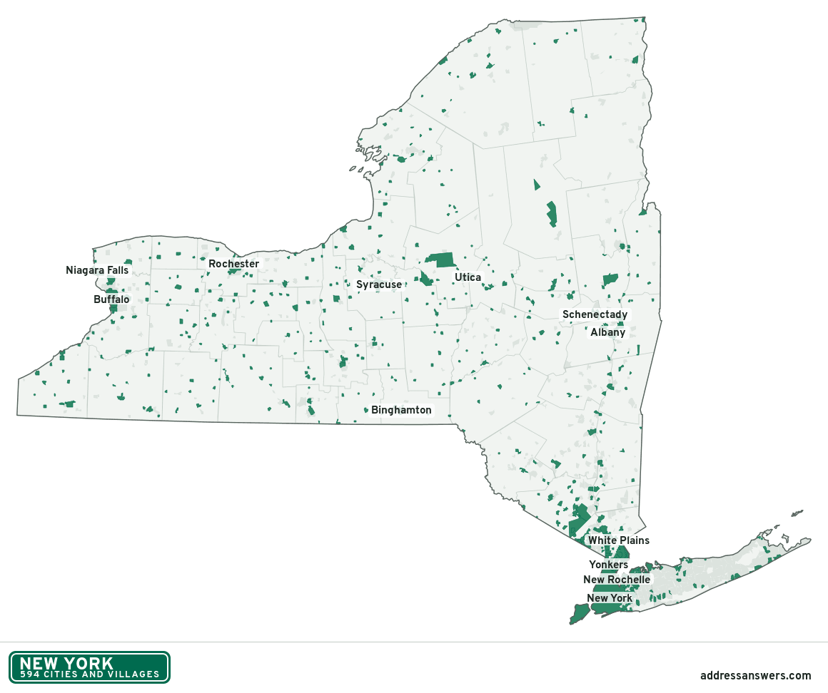
New York city limits map image
The map above as a picture: every New York city and town in green, with county lines. Boundaries from the Census Bureau, as of January 1, 2025.
You’re welcome to use it in a document or on your own site, with a link back to this page.
Download the map (PNG, 1,160 × 972)Questions about New York city limits
How many cities and villages are in New York?
New York has 594 incorporated places: 62 cities and 532 villages, by the Census Bureau’s boundary files for 2025.
What is the largest city in New York?
By population, New York City, with about 8.5 million residents (2020–2024 American Community Survey 5-year estimates). It is also the largest by land area, at 300.5 square miles.
What is the smallest village in New York?
By the Census Bureau’s estimate, Saltaire, with 8 residents. Estimates for places this small have a wide margin of error, so treat it as a rough count.
How much of New York is unincorporated?
96% of its land and 7.1 million of its residents (36%) are outside every city or village. There, local government is the town and the county. The state also has 699 named unincorporated communities; the largest is Cheektowaga.
Is Cheektowaga, NY a city?
No. Cheektowaga is a census-designated place: a community the Census Bureau maps for statistics, with no city government of its own. About 76,056 people live there, in Erie County, in a town rather than a city or village. An address there is outside city limits, even if its mailing address says otherwise.
Is Levittown, NY a city?
No. Levittown is a census-designated place: a community the Census Bureau maps for statistics, with no city government of its own. About 51,904 people live there, in Nassau County, in a town rather than a city or village. An address there is outside city limits, even if its mailing address says otherwise.
Which cities and villages in New York are in more than one county?
Ten of the 594 cross a county line, by at least 1% of their land. The largest: New York City (Queens, Kings, Richmond, Bronx, and New York), Geneva (Ontario and Seneca), and Saranac Lake (Franklin and Essex). Check an address to see which county it’s in.
Which county in New York has the most cities and villages?
Nassau County, with 66 at least partly inside it. Every county in New York has at least one.
Bordering states
More answers for a New York address
Each tool checks the same address and puts its own answer first.
- County Census Your county, plus the township or town where those exist. Find your county
- School district Census The public school district that covers the address. Find your school district
- Flood zone FEMA The FEMA zone in plain English, and whether lenders require flood insurance. Check flood zone
- USDA home loans USDA Whether the property is in an area eligible for a USDA Rural Development loan. Check USDA eligibility
- Voting districts Census Your congressional district and your state senate and state house districts. Included in every check
Places, boundaries, land area and counties: US Census Bureau 2025 cartographic boundary files (boundaries as of January 1, 2025). A place is listed in each county that holds at least 1% of its land. Population: 2020–2024 American Community Survey 5-year estimates. Data updated October 24, 2026; page updated October 25, 2026. Boundaries change through annexation; your city or county has the official map.