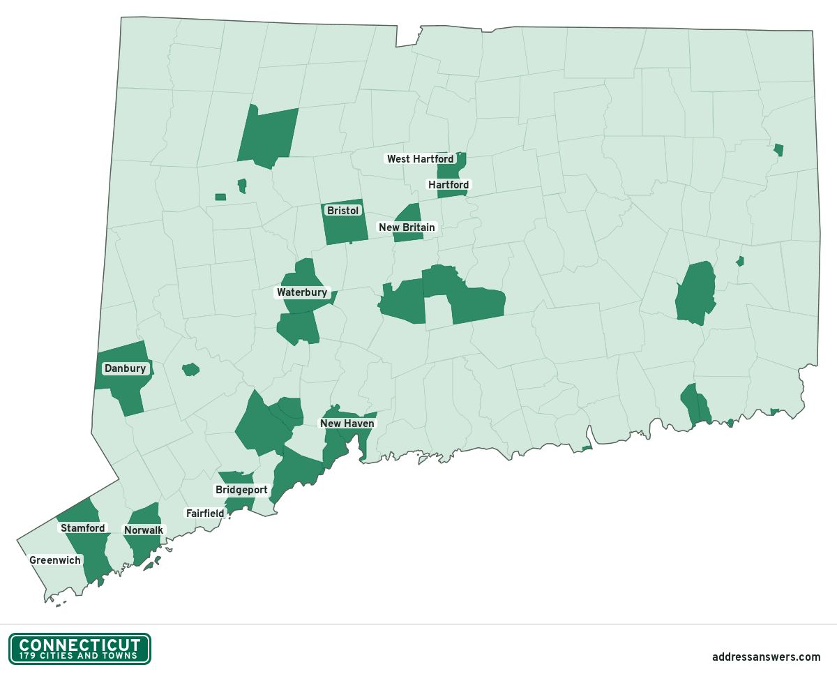
Connecticut city limits map
Connecticut has 179 incorporated places: 20 cities, 149 towns, and 10 boroughs. Between them they cover the whole state, so there is no unincorporated land. Enter an address to see which one it’s in.
Result for
The map couldn’t load. The answers don’t depend on it.
The boundary couldn’t load. The answer doesn’t depend on it.
Census Geocoder match
More about this address
Sources and limits
- Census
- US Census Bureau Geocoder, current boundaries
- FEMA
- National Flood Hazard Layer, effective flood maps
- USDA
- Rural Development property eligibility
- Map
- Boundaries from Census TIGERweb, flood zones drawn by FEMA, eligible areas from USDA, base map © OpenStreetMap contributors
Census boundaries are updated once a year, so a recent annexation may not show yet. Informational only, not an official determination. Verify with your city or county.
Connecticut at a glance
- Incorporated places
- 179
- 20 cities, 149 towns, and 10 boroughs
- Residents in a municipality
- 100%
- 3,624,508 of 3,624,508
- Land in a municipality
- 100%
- 4,843 of 4,843 sq mi
- Planning regions
- 9
- Every one has at least one
- Largest city
- Bridgeport
- 149,153 residents
How local government works in Connecticut
Every part of Connecticut belongs to one of its 169 towns, so no address is unincorporated. Its cities and boroughs sit inside towns, and many share their town’s boundary.
Connecticut has no county governments. Since 2022 the Census Bureau has used nine planning regions in their place, so a Connecticut result names a planning region.
City limits maps for 5 Connecticut cities
Every Connecticut city with 100,000 or more residents has its own page: the boundary in detail, the places around it and its school districts.
All 179 cities and towns in Connecticut
Every incorporated place, largest first, with the planning regions it’s in and its size. An address inside one of these is inside city limits.
| Name | Type | Planning region | Population | Land (sq mi) |
|---|---|---|---|---|
| Bridgeport | City | Greater Bridgeport Planning Region | 149,153 | 16.1 |
| Stamford | City | Western Connecticut Planning Region | 137,144 | 37.6 |
| New Haven | City | South Central Connecticut Planning Region | 134,349 | 18.7 |
| Hartford | City | Capitol Planning Region | 121,127 | 17.4 |
| Waterbury | City | Naugatuck Valley Planning Region | 114,869 | 28.6 |
| Norwalk | City | Western Connecticut Planning Region | 92,187 | 22.9 |
| Danbury | City | Western Connecticut Planning Region | 87,263 | 42.0 |
| New Britain | City | Capitol Planning Region | 74,223 | 13.4 |
| Greenwich | Town | Western Connecticut Planning Region | 63,856 | 47.7 |
| West Hartford | Town | Capitol Planning Region | 63,620 | 21.8 |
| Fairfield | Town | Greater Bridgeport Planning Region | 63,416 | 29.9 |
| Bristol | City | Naugatuck Valley Planning Region | 61,462 | 26.4 |
| Hamden | Town | South Central Connecticut Planning Region | 61,045 | 32.7 |
| Meriden | City | South Central Connecticut Planning Region | 60,545 | 23.7 |
| Manchester | Town | Capitol Planning Region | 59,635 | 27.4 |
| West Haven | City | South Central Connecticut Planning Region | 55,351 | 10.8 |
| Stratford | Town | Greater Bridgeport Planning Region | 52,790 | 17.5 |
| Milford | City | South Central Connecticut Planning Region | 51,023 | 21.9 |
| East Hartford | Town | Capitol Planning Region | 50,918 | 18.0 |
| Middletown | City | Lower Connecticut River Valley Planning Region | 47,958 | 41.0 |
| Wallingford | Town | South Central Connecticut Planning Region | 44,362 | 39.2 |
| Southington | Town | Capitol Planning Region | 43,803 | 35.9 |
| Shelton | City | Naugatuck Valley Planning Region | 41,889 | 30.6 |
| Enfield | Town | Capitol Planning Region | 41,090 | 33.3 |
| Norwich | City | Southeastern Connecticut Planning Region | 39,973 | 28.1 |
| Groton | Town | Southeastern Connecticut Planning Region | 38,130 | 31.1 |
| Trumbull | Town | Greater Bridgeport Planning Region | 37,281 | 23.2 |
| Torrington | City | Northwest Hills Planning Region | 35,547 | 39.8 |
| Glastonbury | Town | Capitol Planning Region | 35,293 | 51.3 |
| Naugatuck | Borough | Naugatuck Valley Planning Region | 31,800 | 16.4 |
| Newington | Town | Capitol Planning Region | 30,896 | 13.1 |
| Vernon | Town | Capitol Planning Region | 30,577 | 17.7 |
| Windsor | Town | Capitol Planning Region | 29,468 | 29.5 |
| Cheshire | Town | Naugatuck Valley Planning Region | 29,040 | 32.8 |
| New Milford | Town | Western Connecticut Planning Region | 28,334 | 61.6 |
| Branford | Town | South Central Connecticut Planning Region | 28,217 | 21.8 |
| East Haven | Town | South Central Connecticut Planning Region | 27,806 | 12.3 |
| New London | City | Southeastern Connecticut Planning Region | 27,625 | 5.61 |
| Newtown | Town | Western Connecticut Planning Region | 27,593 | 57.5 |
| Westport | Town | Western Connecticut Planning Region | 27,528 | 20.0 |
| Wethersfield | Town | Capitol Planning Region | 27,250 | 12.3 |
| Farmington | Town | Capitol Planning Region | 27,134 | 27.9 |
| South Windsor | Town | Capitol Planning Region | 26,907 | 28.1 |
| Mansfield | Town | Capitol Planning Region | 25,358 | 44.6 |
| Ridgefield | Town | Western Connecticut Planning Region | 25,109 | 34.5 |
| Simsbury | Town | Capitol Planning Region | 25,066 | 33.9 |
| North Haven | Town | South Central Connecticut Planning Region | 24,336 | 20.8 |
| Windham | Town | Southeastern Connecticut Planning Region | 23,961 | 26.8 |
| Watertown | Town | Naugatuck Valley Planning Region | 22,253 | 29.0 |
| Guilford | Town | South Central Connecticut Planning Region | 22,108 | 47.1 |
| Darien | Town | Western Connecticut Planning Region | 21,936 | 12.7 |
| Bloomfield | Town | Capitol Planning Region | 21,754 | 26.1 |
| Rocky Hill | Town | Capitol Planning Region | 20,880 | 13.5 |
| New Canaan | Town | Western Connecticut Planning Region | 20,870 | 22.2 |
| Bethel | Town | Western Connecticut Planning Region | 20,796 | 17.0 |
| Berlin | Town | Capitol Planning Region | 20,361 | 26.3 |
| Southbury | Town | Naugatuck Valley Planning Region | 20,071 | 39.0 |
| Waterford | Town | Southeastern Connecticut Planning Region | 19,673 | 32.9 |
| Ansonia | City | Naugatuck Valley Planning Region | 19,033 | 6.02 |
| Monroe | Town | Greater Bridgeport Planning Region | 18,949 | 26.1 |
| Avon | Town | Capitol Planning Region | 18,946 | 23.2 |
| Wilton | Town | Western Connecticut Planning Region | 18,777 | 26.8 |
| East Lyme | Town | Southeastern Connecticut Planning Region | 18,721 | 34.0 |
| Stonington | Town | Southeastern Connecticut Planning Region | 18,478 | 38.6 |
| Montville | Town | Southeastern Connecticut Planning Region | 17,950 | 41.8 |
| Killingly | Town | Northeastern Connecticut Planning Region | 17,867 | 48.3 |
| Brookfield | Town | Western Connecticut Planning Region | 17,706 | 19.7 |
| Madison | Town | South Central Connecticut Planning Region | 17,616 | 36.1 |
| Plainville | Town | Capitol Planning Region | 17,551 | 9.71 |
| Seymour | Town | Naugatuck Valley Planning Region | 16,889 | 14.5 |
| Ellington | Town | Capitol Planning Region | 16,455 | 34.0 |
| Wolcott | Town | Naugatuck Valley Planning Region | 16,279 | 20.4 |
| Suffield | Town | Capitol Planning Region | 15,702 | 42.3 |
| Colchester | Town | Southeastern Connecticut Planning Region | 15,648 | 48.9 |
| Ledyard | Town | Southeastern Connecticut Planning Region | 15,433 | 38.2 |
| Plainfield | Town | Northeastern Connecticut Planning Region | 15,141 | 42.4 |
| Tolland | Town | Capitol Planning Region | 14,606 | 39.6 |
| Cromwell | Town | Lower Connecticut River Valley Planning Region | 14,334 | 12.5 |
| Orange | Town | South Central Connecticut Planning Region | 14,315 | 17.2 |
| New Fairfield | Town | Western Connecticut Planning Region | 13,584 | 20.4 |
| North Branford | Town | South Central Connecticut Planning Region | 13,503 | 24.8 |
| Clinton | Town | Lower Connecticut River Valley Planning Region | 13,377 | 16.2 |
| Oxford | Town | Naugatuck Valley Planning Region | 12,991 | 32.7 |
| East Hampton | Town | Lower Connecticut River Valley Planning Region | 12,925 | 35.7 |
| Windsor Locks | Town | Capitol Planning Region | 12,579 | 9.02 |
| Derby | City | Naugatuck Valley Planning Region | 12,487 | 5.06 |
| Coventry | Town | Capitol Planning Region | 12,326 | 37.6 |
| Plymouth | Town | Naugatuck Valley Planning Region | 11,746 | 21.9 |
| Griswold | Town | Southeastern Connecticut Planning Region | 11,530 | 34.7 |
| Stafford | Town | Capitol Planning Region | 11,511 | 58.0 |
| East Windsor | Town | Capitol Planning Region | 11,213 | 26.3 |
| Granby | Town | Capitol Planning Region | 11,184 | 40.7 |
| Old Saybrook | Town | Lower Connecticut River Valley Planning Region | 10,575 | 15.1 |
| Weston | Town | Western Connecticut Planning Region | 10,396 | 19.8 |
| Somers | Town | Capitol Planning Region | 10,308 | 28.5 |
| Winchester | Town | Northwest Hills Planning Region | 10,284 | 32.5 |
| Canton | Town | Capitol Planning Region | 10,144 | 24.6 |
| Woodbury | Town | Naugatuck Valley Planning Region | 9,833 | 36.4 |
| Burlington | Town | Northwest Hills Planning Region | 9,680 | 29.7 |
| Groton | City | Southeastern Connecticut Planning Region | 9,490 | 3.08 |
| Prospect | Town | Naugatuck Valley Planning Region | 9,458 | 14.2 |
| Portland | Town | Lower Connecticut River Valley Planning Region | 9,434 | 23.4 |
| Thompson | Town | Northeastern Connecticut Planning Region | 9,337 | 46.9 |
| Putnam | Town | Northeastern Connecticut Planning Region | 9,292 | 20.3 |
| Hebron | Town | Capitol Planning Region | 9,157 | 36.9 |
| Woodbridge | Town | South Central Connecticut Planning Region | 9,073 | 18.8 |
| East Haddam | Town | Lower Connecticut River Valley Planning Region | 8,969 | 54.3 |
| Redding | Town | Western Connecticut Planning Region | 8,780 | 31.5 |
| Haddam | Town | Lower Connecticut River Valley Planning Region | 8,644 | 43.9 |
| Brooklyn | Town | Northeastern Connecticut Planning Region | 8,517 | 29.1 |
| Woodstock | Town | Northeastern Connecticut Planning Region | 8,319 | 60.7 |
| Litchfield | Town | Northwest Hills Planning Region | 8,260 | 56.1 |
| Middlebury | Town | Naugatuck Valley Planning Region | 7,807 | 17.8 |
| Old Lyme | Town | Lower Connecticut River Valley Planning Region | 7,679 | 23.0 |
| Easton | Town | Greater Bridgeport Planning Region | 7,670 | 27.4 |
| Thomaston | Town | Naugatuck Valley Planning Region | 7,492 | 12.0 |
| Durham | Town | Lower Connecticut River Valley Planning Region | 7,208 | 23.7 |
| Lebanon | Town | Southeastern Connecticut Planning Region | 7,116 | 54.1 |
| Westbrook | Town | Lower Connecticut River Valley Planning Region | 6,856 | 15.8 |
| Essex | Town | Lower Connecticut River Valley Planning Region | 6,794 | 10.4 |
| New Hartford | Town | Northwest Hills Planning Region | 6,675 | 37.0 |
| Killingworth | Town | Lower Connecticut River Valley Planning Region | 6,240 | 35.3 |
| Beacon Falls | Town | Naugatuck Valley Planning Region | 6,147 | 9.67 |
| Marlborough | Town | Capitol Planning Region | 6,130 | 23.4 |
| Harwinton | Town | Northwest Hills Planning Region | 5,575 | 30.8 |
| Willington | Town | Capitol Planning Region | 5,575 | 33.3 |
| Columbia | Town | Capitol Planning Region | 5,300 | 21.4 |
| Bethany | Town | South Central Connecticut Planning Region | 5,288 | 21.1 |
| East Granby | Town | Capitol Planning Region | 5,238 | 17.5 |
| North Stonington | Town | Southeastern Connecticut Planning Region | 5,160 | 54.2 |
| Canterbury | Town | Northeastern Connecticut Planning Region | 5,124 | 39.9 |
| Bolton | Town | Capitol Planning Region | 4,853 | 14.4 |
| Preston | Town | Southeastern Connecticut Planning Region | 4,821 | 30.8 |
| Deep River | Town | Lower Connecticut River Valley Planning Region | 4,458 | 13.5 |
| Pomfret | Town | Northeastern Connecticut Planning Region | 4,317 | 40.3 |
| Salem | Town | Southeastern Connecticut Planning Region | 4,282 | 28.9 |
| Middlefield | Town | Lower Connecticut River Valley Planning Region | 4,243 | 12.6 |
| Ashford | Town | Northeastern Connecticut Planning Region | 4,226 | 38.8 |
| Salisbury | Town | Northwest Hills Planning Region | 4,224 | 57.2 |
| Lisbon | Town | Southeastern Connecticut Planning Region | 4,211 | 16.3 |
| Danielson | Borough | Northeastern Connecticut Planning Region | 4,209 | 1.09 |
| Chester | Town | Lower Connecticut River Valley Planning Region | 3,825 | 16.1 |
| Barkhamsted | Town | Northwest Hills Planning Region | 3,678 | 36.3 |
| Washington | Town | Northwest Hills Planning Region | 3,676 | 38.1 |
| Sterling | Town | Northeastern Connecticut Planning Region | 3,629 | 27.2 |
| Sherman | Town | Western Connecticut Planning Region | 3,554 | 21.9 |
| Jewett City | Borough | Southeastern Connecticut Planning Region | 3,429 | 0.70 |
| Bethlehem | Town | Naugatuck Valley Planning Region | 3,423 | 19.4 |
| North Canaan | Town | Northwest Hills Planning Region | 3,221 | 19.4 |
| Goshen | Town | Northwest Hills Planning Region | 3,196 | 43.6 |
| Andover | Town | Capitol Planning Region | 3,152 | 15.4 |
| Kent | Town | Northwest Hills Planning Region | 3,056 | 48.6 |
| Sprague | Town | Southeastern Connecticut Planning Region | 2,962 | 13.2 |
| Sharon | Town | Northwest Hills Planning Region | 2,723 | 58.8 |
| Voluntown | Town | Northeastern Connecticut Planning Region | 2,604 | 39.0 |
| Lyme | Town | Lower Connecticut River Valley Planning Region | 2,303 | 31.8 |
| Bozrah | Town | Southeastern Connecticut Planning Region | 2,293 | 20.0 |
| Roxbury | Town | Northwest Hills Planning Region | 2,185 | 26.3 |
| Morris | Town | Northwest Hills Planning Region | 2,164 | 17.4 |
| Chaplin | Town | Northeastern Connecticut Planning Region | 2,070 | 19.4 |
| Franklin | Town | Southeastern Connecticut Planning Region | 2,004 | 19.7 |
| Newtown | Borough | Western Connecticut Planning Region | 1,898 | 2.30 |
| Hartland | Town | Northwest Hills Planning Region | 1,840 | 33.0 |
| Norfolk | Town | Northwest Hills Planning Region | 1,723 | 45.3 |
| Eastford | Town | Northeastern Connecticut Planning Region | 1,679 | 28.9 |
| Woodmont | Borough | South Central Connecticut Planning Region | 1,661 | 0.27 |
| Bridgewater | Town | Western Connecticut Planning Region | 1,658 | 16.4 |
| Hampton | Town | Northeastern Connecticut Planning Region | 1,647 | 25.1 |
| Scotland | Town | Northeastern Connecticut Planning Region | 1,599 | 18.6 |
| Colebrook | Town | Northwest Hills Planning Region | 1,494 | 31.6 |
| Cornwall | Town | Northwest Hills Planning Region | 1,425 | 46.1 |
| Warren | Town | Northwest Hills Planning Region | 1,415 | 26.3 |
| Litchfield | Borough | Northwest Hills Planning Region | 1,251 | 1.37 |
| Canaan | Town | Northwest Hills Planning Region | 1,175 | 32.9 |
| Union | Town | Northeastern Connecticut Planning Region | 944 | 28.8 |
| Stonington | Borough | Southeastern Connecticut Planning Region | 934 | 0.34 |
| Bantam | Borough | Northwest Hills Planning Region | 810 | 1.01 |
| Groton Long Point | Borough | Southeastern Connecticut Planning Region | 546 | 0.43 |
| Fenwick | Borough | Lower Connecticut River Valley Planning Region | 49 | 0.39 |
Showing 1–50 of 179
Planning regions in Connecticut
9 planning regions, with how many cities and towns have land in each and the largest whose main planning region it is.
| Planning region | Cities | Largest | Population | Land (sq mi) |
|---|---|---|---|---|
| Capitol Planning Region | 38 | Hartford | 977,290 | 1,027 |
| Western Connecticut Planning Region | 19 | Stamford | 627,071 | 532.1 |
| South Central Connecticut Planning Region | 16 | New Haven | 570,598 | 367.3 |
| Naugatuck Valley Planning Region | 19 | Waterbury | 454,969 | 412.8 |
| Greater Bridgeport Planning Region | 6 | Bridgeport | 329,259 | 140.2 |
| Southeastern Connecticut Planning Region | 23 | Norwich | 279,971 | 598.1 |
| Lower Connecticut River Valley Planning Region | 18 | Middletown | 175,822 | 424.1 |
| Northwest Hills Planning Region | 23 | Torrington | 113,216 | 786.6 |
| Northeastern Connecticut Planning Region | 17 | Killingly | 96,312 | 553.9 |
Connecticut city limits map image
The map above as a picture: every Connecticut city and town in green, with county lines. Boundaries from the Census Bureau, as of January 1, 2025.
You’re welcome to use it in a document or on your own site, with a link back to this page.
Download the map (PNG, 1,200 × 966)Questions about Connecticut city limits
How many cities and towns are in Connecticut?
Connecticut has 179 incorporated places: 20 cities, 149 towns, and 10 boroughs, by the Census Bureau’s boundary files for 2025.
What is the largest city in Connecticut?
By population, Bridgeport, with about 149,153 residents (2020–2024 American Community Survey 5-year estimates). By land area the largest is New Milford, at 61.6 square miles (Bridgeport: 16.1).
What is the smallest borough in Connecticut?
By the Census Bureau’s estimate, Fenwick, with 49 residents. Estimates for places this small have a wide margin of error, so treat it as a rough count.
Which planning region in Connecticut has the most cities and towns?
Capitol Planning Region, with 38 at least partly inside it. Every planning region in Connecticut has at least one.
Bordering states
More answers for a Connecticut address
Each tool checks the same address and puts its own answer first.
- County Census Your county, plus the township or town where those exist. Find your county
- School district Census The public school district that covers the address. Find your school district
- Flood zone FEMA The FEMA zone in plain English, and whether lenders require flood insurance. Check flood zone
- USDA home loans USDA Whether the property is in an area eligible for a USDA Rural Development loan. Check USDA eligibility
- Voting districts Census Your congressional district and your state senate and state house districts. Included in every check
Places, boundaries, land area and planning regions: US Census Bureau 2025 cartographic boundary files (boundaries as of January 1, 2025). A place is listed in each planning region that holds at least 1% of its land. Population: 2020–2024 American Community Survey 5-year estimates. Data updated October 24, 2026; page updated October 25, 2026. Boundaries change through annexation; your city or planning region has the official map.