Pasadena, TX city limits map
Enter an address to check if it’s inside Pasadena city limits.
Result for
The map couldn’t load. The answers don’t depend on it.
The boundary couldn’t load. The answer doesn’t depend on it.
Census Geocoder match
More about this address
Sources and limits
- Census
- US Census Bureau Geocoder, current boundaries
- FEMA
- National Flood Hazard Layer, effective flood maps
- USDA
- Rural Development property eligibility
- Map
- Boundaries from Census TIGERweb, flood zones drawn by FEMA, eligible areas from USDA, base map © OpenStreetMap contributors
Census boundaries are updated once a year, so a recent annexation may not show yet. Informational only, not an official determination. Verify with your city or county.
Pasadena at a glance
- Population
- 149,433
- ACS 5-year estimate
- Land area
- 43.7 sq mi
- Plus 1.06 sq mi of water
- Household income
- $64,927
- Median, ACS 5-year estimate
- Home value
- $209,600
- Median, owner-occupied homes
- County
- Harris
Cities bordering Pasadena
Separate cities with their own limits.
- Houston
- La Porte
- Deer Park
- South Houston
- Seabrook
- Nassau Bay
- Taylor Lake Village
- El Lago
- Shoreacres
School districts in Pasadena
Share of the city’s area each district covers. District lines don’t follow city limits.
- Pasadena Independent School District
- Deer Park Independent School District
- Clear Creek Independent School District
- La Porte Independent School District
City limits maps near Pasadena
Other cities with a map here, by straight-line distance from the middle of Pasadena.
More Texas city limits maps
The 41 other cities in Texas with a page here, largest first. Every incorporated place in the state, with its county and population, is on the Texas city limits map.
- Houston
- San Antonio
- Dallas
- Austin
- Fort Worth
- El Paso
- Arlington
- Corpus Christi
- Plano
- Lubbock
- Laredo
- Irving
- Garland
- Frisco
- McKinney
- Amarillo
- Grand Prairie
- Brownsville
- Killeen
- Denton
- Mesquite
- McAllen
- Waco
- Midland
- Carrollton
- Lewisville
- Abilene
- Round Rock
- Pearland
- College Station
- Richardson
- League City
- Odessa
- Beaumont
- Allen
- Sugar Land
- Tyler
- New Braunfels
- Edinburg
- Wichita Falls
- Conroe
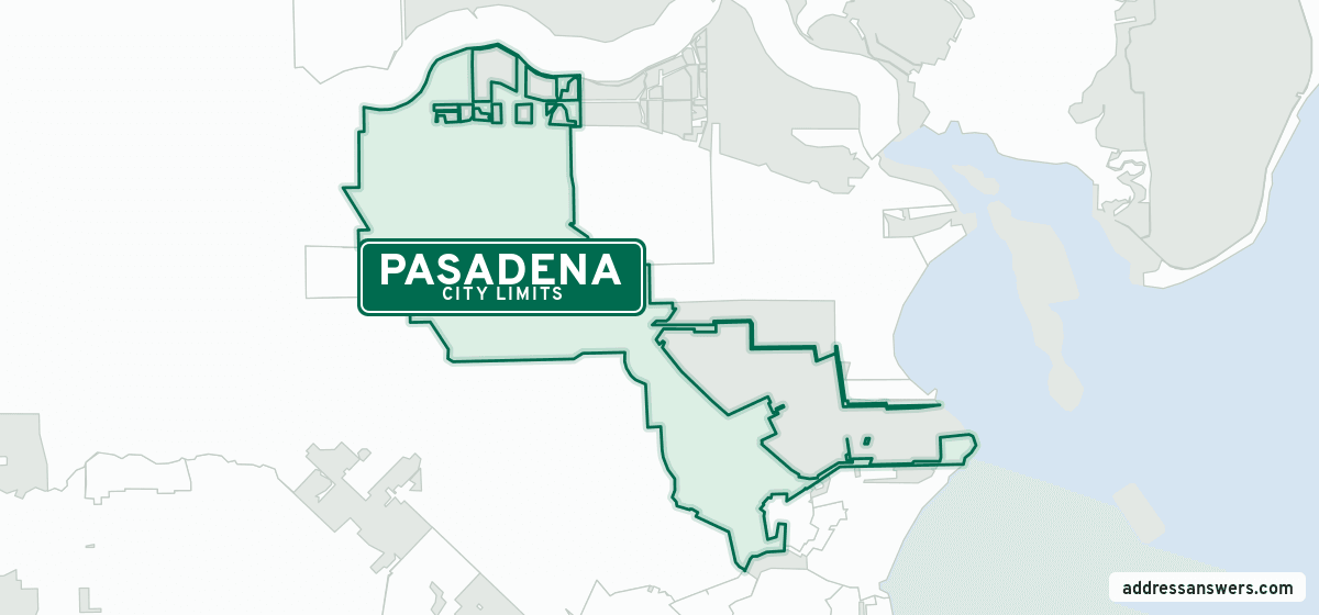
Pasadena, TX city limits map image
The map above as a picture: the Pasadena city limits in green, the cities around it, and unincorporated land in grey. Boundaries from the Census Bureau, as of January 1, 2025.
You’re welcome to use it in a document or on your own site, with a link back to this page.
Download the map (PNG, 1,200 × 560)Questions about Pasadena city limits
How do I know if my address is in Pasadena city limits?
Enter it in the search at the top of this page. We check its location against the Census Bureau’s current boundaries and tell you whether it’s inside Pasadena, and if not, which city or county it’s in. For a tax or legal question, look for the city on your property tax bill, or ask the city’s planning department.
What county is Pasadena, TX in?
Pasadena is in Harris County.
How big is Pasadena, TX?
Pasadena’s city limits take in 43.7 square miles of land, plus 1.06 square miles of water. The Census Bureau estimates that 149,433 people live inside them (2020–2024 American Community Survey 5-year estimates).
What school district is Pasadena in?
Four school districts cover parts of Pasadena. The largest by area: Pasadena Independent School District (53%), Deer Park Independent School District (20%), and Clear Creek Independent School District (20%). City limits and school district lines don’t match, so check the exact address.
Does a Pasadena ZIP code or mailing address mean I’m in the city?
Not always. The Postal Service sets ZIP codes and mailing city names to deliver mail, and they often reach past city limits. Check the exact address above to be sure.
More answers for a Pasadena address
Each tool checks the same address and puts its own answer first.
- County Census Your county, plus the township or town where those exist. Find your county
- School district Census The public school district that covers the address. Find your school district
- Flood zone FEMA The FEMA zone in plain English, and whether lenders require flood insurance. Check flood zone
- USDA home loans USDA Whether the property is in an area eligible for a USDA Rural Development loan. Check USDA eligibility
- Voting districts Census Your congressional district and your state senate and state house districts. Included in every check
Boundaries, land area, counties and school districts: US Census Bureau 2025 cartographic boundary files (boundaries as of January 1, 2025). Shares are of the city’s mapped area. Population, income and home value: 2020–2024 American Community Survey 5-year estimates. Data updated October 13, 2026; page updated October 27, 2026. Boundaries change through annexation; your city or county has the official map.