Maine city limits map
Maine has 482 incorporated places: 23 cities, 430 towns, and 29 plantations. Between them they cover 53% of the land; the rest is unorganized. Enter an address to see which one it’s in.
Result for
The map couldn’t load. The answers don’t depend on it.
The boundary couldn’t load. The answer doesn’t depend on it.
Census Geocoder match
More about this address
Sources and limits
- Census
- US Census Bureau Geocoder, current boundaries
- FEMA
- National Flood Hazard Layer, effective flood maps
- USDA
- Rural Development property eligibility
- Map
- Boundaries from Census TIGERweb, flood zones drawn by FEMA, eligible areas from USDA, base map © OpenStreetMap contributors
Census boundaries are updated once a year, so a recent annexation may not show yet. Informational only, not an official determination. Verify with your city or county.
Maine at a glance
- Incorporated places
- 482
- 23 cities, 430 towns, and 29 plantations
- Residents in a municipality
- 99.2%
- 1,376,118 of 1,387,817
- Land in a municipality
- 53%
- 16,394 of 30,845 sq mi
- Counties
- 16
- Every one has at least one
- Largest city
- Portland
- 68,854 residents
How local government works in Maine
Maine is divided into cities, towns and plantations (a simpler form of town government). About 47% of its land, mostly in the north and west, is unorganized territory with no local government; the state and the counties provide services there. About 11,699 people live in it.
All 482 cities and towns in Maine
Every incorporated place, largest first, with the counties it’s in and its size. An address inside one of these is inside city limits.
| Name | Type | County | Population | Land (sq mi) |
|---|---|---|---|---|
| Portland | City | Cumberland | 68,854 | 21.5 |
| Lewiston | City | Androscoggin | 38,324 | 34.1 |
| Bangor | City | Penobscot | 31,938 | 34.3 |
| South Portland | City | Cumberland | 26,930 | 12.0 |
| Auburn | City | Androscoggin | 24,602 | 59.3 |
| Scarborough | Town | Cumberland | 23,215 | 47.7 |
| Biddeford | City | York | 22,498 | 30.1 |
| Brunswick | Town | Cumberland | 22,336 | 46.8 |
| Sanford | City | York | 22,247 | 47.8 |
| Saco | City | York | 20,819 | 38.6 |
| Westbrook | City | Cumberland | 20,775 | 17.2 |
| Windham | Town | Cumberland | 19,188 | 46.6 |
| Augusta | City | Kennebec | 19,077 | 55.1 |
| Gorham | Town | Cumberland | 18,300 | 50.6 |
| Waterville | City | Kennebec | 17,077 | 13.5 |
| York | Town | York | 13,986 | 54.7 |
| Falmouth | Town | Cumberland | 12,755 | 29.4 |
| Orono | Town | Penobscot | 11,902 | 18.2 |
| Kennebunk | Town | York | 11,820 | 35.1 |
| Wells | Town | York | 11,713 | 57.7 |
| Standish | Town | Cumberland | 10,662 | 59.1 |
| Kittery | Town | York | 10,473 | 17.8 |
| Lisbon | Town | Androscoggin | 9,750 | 22.8 |
| Topsham | Town | Sagadahoc | 9,706 | 32.2 |
| Brewer | City | Penobscot | 9,652 | 15.2 |
| Cape Elizabeth | Town | Cumberland | 9,606 | 14.9 |
| Old Orchard Beach | Town | York | 9,244 | 7.43 |
| Yarmouth | Town | Cumberland | 9,053 | 13.4 |
| Bath | City | Sagadahoc | 8,815 | 9.12 |
| Freeport | Town | Cumberland | 8,802 | 34.7 |
| Presque Isle | City | Aroostook | 8,736 | 75.8 |
| Ellsworth | City | Hancock | 8,657 | 79.3 |
| Skowhegan | Town | Somerset | 8,653 | 58.8 |
| Cumberland | Town | Cumberland | 8,647 | 22.9 |
| Buxton | Town | York | 8,512 | 40.5 |
| Gray | Town | Cumberland | 8,429 | 43.3 |
| Berwick | Town | York | 8,175 | 37.5 |
| Farmington | Town | Franklin | 8,157 | 55.7 |
| Waterboro | Town | York | 8,055 | 55.3 |
| Winslow | Town | Kennebec | 8,023 | 36.8 |
| Hampden | Town | Penobscot | 7,896 | 37.9 |
| South Berwick | Town | York | 7,670 | 32.1 |
| Old Town | City | Penobscot | 7,470 | 38.8 |
| Caribou | City | Aroostook | 7,382 | 79.3 |
| Eliot | Town | York | 7,146 | 19.8 |
| Rockland | City | Knox | 7,035 | 12.8 |
| Belfast | City | Waldo | 6,986 | 34.1 |
| Hermon | Town | Penobscot | 6,727 | 35.9 |
| Lebanon | Town | York | 6,629 | 55.0 |
| Fairfield | Town | Somerset | 6,519 | 53.7 |
| Oakland | Town | Kennebec | 6,309 | 25.7 |
| Winthrop | Town | Kennebec | 6,191 | 31.2 |
| Gardiner | City | Kennebec | 6,088 | 15.7 |
| Houlton | Town | Aroostook | 6,056 | 36.7 |
| Poland | Town | Androscoggin | 5,954 | 42.2 |
| Rumford | Town | Oxford | 5,942 | 68.6 |
| Turner | Town | Androscoggin | 5,891 | 59.3 |
| New Gloucester | Town | Cumberland | 5,766 | 47.1 |
| Bridgton | Town | Cumberland | 5,642 | 56.9 |
| Paris | Town | Oxford | 5,317 | 40.8 |
| Waldoboro | Town | Lincoln | 5,253 | 71.5 |
| Bar Harbor | Town | Hancock | 5,244 | 42.2 |
| Camden | Town | Knox | 5,242 | 18.2 |
| Norway | Town | Oxford | 5,228 | 45.0 |
| North Berwick | Town | York | 5,129 | 38.0 |
| Sabattus | Town | Androscoggin | 5,116 | 25.7 |
| Harpswell | Town | Cumberland | 5,046 | 24.1 |
| Bucksport | Town | Hancock | 5,016 | 51.5 |
| Warren | Town | Knox | 4,932 | 46.5 |
| Lincoln | Town | Penobscot | 4,890 | 67.8 |
| Hollis | Town | York | 4,872 | 32.0 |
| Sidney | Town | Kennebec | 4,790 | 42.2 |
| Madison | Town | Somerset | 4,782 | 51.9 |
| Glenburn | Town | Penobscot | 4,737 | 27.2 |
| Jay | Town | Franklin | 4,657 | 48.4 |
| Lyman | Town | York | 4,612 | 39.0 |
| Raymond | Town | Cumberland | 4,610 | 33.2 |
| Vassalboro | Town | Kennebec | 4,592 | 44.3 |
| China | Town | Kennebec | 4,526 | 49.9 |
| Dover-Foxcroft | Town | Piscataquis | 4,506 | 67.8 |
| Arundel | Town | York | 4,418 | 23.9 |
| Greene | Town | Androscoggin | 4,417 | 32.3 |
| Oxford | Town | Oxford | 4,333 | 38.7 |
| Durham | Town | Androscoggin | 4,262 | 38.3 |
| North Yarmouth | Town | Cumberland | 4,240 | 21.2 |
| Monmouth | Town | Kennebec | 4,162 | 34.0 |
| Fort Kent | Town | Aroostook | 4,150 | 54.1 |
| Millinocket | Town | Penobscot | 4,115 | 15.9 |
| Limington | Town | York | 4,017 | 42.0 |
| Naples | Town | Cumberland | 3,985 | 31.8 |
| Pittsfield | Town | Somerset | 3,930 | 48.2 |
| Wiscasset | Town | Lincoln | 3,874 | 24.6 |
| Wilton | Town | Franklin | 3,862 | 41.3 |
| Madawaska | Town | Aroostook | 3,853 | 55.6 |
| Orrington | Town | Penobscot | 3,853 | 25.0 |
| Winterport | Town | Waldo | 3,850 | 35.5 |
| Dexter | Town | Penobscot | 3,822 | 35.1 |
| Casco | Town | Cumberland | 3,696 | 31.3 |
| West Gardiner | Town | Kennebec | 3,696 | 24.6 |
| Kennebunkport | Town | York | 3,684 | 20.6 |
| Litchfield | Town | Kennebec | 3,680 | 37.4 |
| Rockport | Town | Knox | 3,675 | 21.6 |
| Richmond | Town | Sagadahoc | 3,566 | 30.4 |
| Fryeburg | Town | Oxford | 3,489 | 58.3 |
| Limerick | Town | York | 3,400 | 27.1 |
| Clinton | Town | Kennebec | 3,385 | 43.9 |
| Holden | Town | Penobscot | 3,352 | 31.3 |
| Belgrade | Town | Kennebec | 3,351 | 43.2 |
| Fort Fairfield | Town | Aroostook | 3,309 | 77.0 |
| Norridgewock | Town | Somerset | 3,288 | 50.0 |
| Bowdoin | Town | Sagadahoc | 3,188 | 43.5 |
| Woolwich | Town | Sagadahoc | 3,158 | 35.1 |
| Newport | Town | Penobscot | 3,143 | 29.5 |
| Bowdoinham | Town | Sagadahoc | 3,142 | 34.4 |
| Mechanic Falls | Town | Androscoggin | 3,134 | 11.0 |
| Alfred | Town | York | 3,125 | 27.3 |
| Boothbay | Town | Lincoln | 3,102 | 22.0 |
| Livermore Falls | Town | Androscoggin | 3,102 | 19.7 |
| Calais | City | Washington | 3,097 | 34.3 |
| Milford | Town | Penobscot | 3,095 | 45.6 |
| Pittston | Town | Kennebec | 3,093 | 32.2 |
| Levant | Town | Penobscot | 3,069 | 30.1 |
| Farmingdale | Town | Kennebec | 3,017 | 11.2 |
| Corinth | Town | Penobscot | 2,990 | 40.3 |
| Shapleigh | Town | York | 2,976 | 38.7 |
| Carmel | Town | Penobscot | 2,941 | 36.7 |
| Bristol | Town | Lincoln | 2,917 | 34.0 |
| Chelsea | Town | Kennebec | 2,823 | 19.5 |
| Blue Hill | Town | Hancock | 2,813 | 62.5 |
| Minot | Town | Androscoggin | 2,794 | 29.6 |
| Mexico | Town | Oxford | 2,782 | 23.3 |
| Benton | Town | Kennebec | 2,770 | 28.4 |
| Thomaston | Town | Knox | 2,769 | 10.9 |
| Acton | Town | York | 2,721 | 37.8 |
| Windsor | Town | Kennebec | 2,690 | 34.6 |
| Union | Town | Knox | 2,663 | 32.2 |
| Searsport | Town | Waldo | 2,655 | 28.7 |
| Readfield | Town | Kennebec | 2,651 | 29.2 |
| Jefferson | Town | Lincoln | 2,647 | 52.6 |
| Bethel | Town | Oxford | 2,617 | 64.6 |
| St. George | Town | Knox | 2,606 | 25.0 |
| Hallowell | City | Kennebec | 2,592 | 5.86 |
| Hancock | Town | Hancock | 2,518 | 30.0 |
| Harrison | Town | Cumberland | 2,513 | 33.2 |
| Deer Isle | Town | Hancock | 2,470 | 29.7 |
| Manchester | Town | Kennebec | 2,424 | 21.4 |
| Buckfield | Town | Oxford | 2,403 | 37.5 |
| Lincolnville | Town | Waldo | 2,396 | 37.3 |
| Anson | Town | Somerset | 2,331 | 47.5 |
| Dayton | Town | York | 2,313 | 17.9 |
| Dixfield | Town | Oxford | 2,300 | 41.3 |
| Leeds | Town | Androscoggin | 2,285 | 40.1 |
| Phippsburg | Town | Sagadahoc | 2,238 | 28.8 |
| Eddington | Town | Penobscot | 2,223 | 25.0 |
| Palmyra | Town | Somerset | 2,209 | 40.2 |
| Albion | Town | Kennebec | 2,204 | 38.8 |
| Corinna | Town | Penobscot | 2,192 | 38.7 |
| Damariscotta | Town | Lincoln | 2,192 | 12.4 |
| Milo | Town | Piscataquis | 2,165 | 33.0 |
| Whitefield | Town | Lincoln | 2,157 | 46.8 |
| Boothbay Harbor | Town | Lincoln | 2,096 | 5.70 |
| Sebago | Town | Cumberland | 2,073 | 32.8 |
| Canaan | Town | Somerset | 2,063 | 41.2 |
| Machias | Town | Washington | 2,020 | 13.9 |
| Otisfield | Town | Oxford | 1,951 | 39.9 |
| Wales | Town | Androscoggin | 1,924 | 16.0 |
| Orland | Town | Hancock | 1,915 | 47.0 |
| Newcastle | Town | Lincoln | 1,913 | 29.1 |
| Nobleboro | Town | Lincoln | 1,906 | 18.9 |
| Mapleton | Town | Aroostook | 1,884 | 34.0 |
| Livermore | Town | Androscoggin | 1,868 | 37.6 |
| West Bath | Town | Sagadahoc | 1,863 | 11.9 |
| Unity | Town | Waldo | 1,858 | 39.4 |
| Van Buren | Town | Aroostook | 1,858 | 33.8 |
| Veazie | Town | Penobscot | 1,847 | 3.03 |
| Surry | Town | Hancock | 1,836 | 37.0 |
| St. Albans | Town | Somerset | 1,831 | 44.8 |
| Brownfield | Town | Oxford | 1,830 | 44.5 |
| West Paris | Town | Oxford | 1,808 | 24.2 |
| Cornish | Town | York | 1,803 | 22.2 |
| Lamoine | Town | Hancock | 1,782 | 17.8 |
| Hiram | Town | Oxford | 1,748 | 37.5 |
| Hope | Town | Knox | 1,748 | 22.0 |
| Porter | Town | Oxford | 1,746 | 31.5 |
| Mount Vernon | Town | Kennebec | 1,716 | 37.9 |
| Parsonsfield | Town | York | 1,715 | 58.9 |
| Pownal | Town | Cumberland | 1,696 | 22.9 |
| Mount Desert | Town | Hancock | 1,671 | 36.9 |
| Dedham | Town | Hancock | 1,656 | 39.3 |
| Stockton Springs | Town | Waldo | 1,652 | 19.6 |
| Searsmont | Town | Waldo | 1,646 | 37.7 |
| Bradley | Town | Penobscot | 1,645 | 49.5 |
| Dresden | Town | Lincoln | 1,645 | 30.5 |
| Franklin | Town | Hancock | 1,628 | 36.5 |
| Washington | Town | Knox | 1,624 | 38.0 |
| Northport | Town | Waldo | 1,621 | 23.8 |
| Gouldsboro | Town | Hancock | 1,615 | 46.3 |
| Randolph | Town | Kennebec | 1,610 | 2.14 |
| Hartland | Town | Somerset | 1,602 | 37.1 |
| Trenton | Town | Hancock | 1,599 | 18.2 |
| Newfield | Town | York | 1,580 | 32.3 |
| Limestone | Town | Aroostook | 1,579 | 40.5 |
| Southwest Harbor | Town | Hancock | 1,553 | 13.5 |
| New Sharon | Town | Franklin | 1,550 | 46.2 |
| Tremont | Town | Hancock | 1,508 | 16.8 |
| Peru | Town | Oxford | 1,501 | 46.7 |
| East Millinocket | Town | Penobscot | 1,495 | 7.10 |
| Owls Head | Town | Knox | 1,482 | 8.88 |
| Newburgh | Town | Penobscot | 1,475 | 31.0 |
| Palermo | Town | Waldo | 1,473 | 40.6 |
| Enfield | Town | Penobscot | 1,462 | 27.7 |
| Cushing | Town | Knox | 1,460 | 19.2 |
| Easton | Town | Aroostook | 1,433 | 38.7 |
| Hodgdon | Town | Aroostook | 1,428 | 39.8 |
| Cornville | Town | Somerset | 1,419 | 40.7 |
| Thorndike | Town | Waldo | 1,403 | 25.3 |
| Mars Hill | Town | Aroostook | 1,398 | 35.1 |
| Chesterville | Town | Franklin | 1,397 | 36.2 |
| Steuben | Town | Washington | 1,388 | 43.0 |
| Fayette | Town | Kennebec | 1,383 | 29.2 |
| South Thomaston | Town | Knox | 1,381 | 11.4 |
| Ogunquit | Town | York | 1,379 | 4.08 |
| Greenbush | Town | Penobscot | 1,378 | 43.8 |
| Howland | Town | Penobscot | 1,367 | 34.9 |
| Castine | Town | Hancock | 1,362 | 7.78 |
| Appleton | Town | Knox | 1,360 | 32.7 |
| Greenville | Town | Piscataquis | 1,355 | 42.3 |
| Washburn | Town | Aroostook | 1,355 | 34.2 |
| Lovell | Town | Oxford | 1,353 | 43.1 |
| Lubec | Town | Washington | 1,346 | 33.2 |
| Baileyville | Town | Washington | 1,339 | 37.3 |
| Kenduskeag | Town | Penobscot | 1,333 | 16.8 |
| Plymouth | Town | Penobscot | 1,319 | 29.7 |
| Hartford | Town | Oxford | 1,314 | 43.9 |
| Hudson | Town | Penobscot | 1,305 | 37.6 |
| Waterford | Town | Oxford | 1,295 | 50.3 |
| Sedgwick | Town | Hancock | 1,274 | 27.0 |
| Eastport | City | Washington | 1,263 | 3.63 |
| Bradford | Town | Penobscot | 1,254 | 41.2 |
| Etna | Town | Penobscot | 1,252 | 24.7 |
| Edgecomb | Town | Lincoln | 1,251 | 18.1 |
| Strong | Town | Franklin | 1,249 | 28.3 |
| Sullivan | Town | Hancock | 1,246 | 26.7 |
| Woodstock | Town | Oxford | 1,233 | 45.7 |
| Linneus | Town | Aroostook | 1,226 | 44.2 |
| East Machias | Town | Washington | 1,223 | 34.9 |
| Milbridge | Town | Washington | 1,222 | 24.2 |
| Vinalhaven | Town | Knox | 1,216 | 23.5 |
| Rome | Town | Kennebec | 1,215 | 25.4 |
| Friendship | Town | Knox | 1,213 | 14.1 |
| Brooks | Town | Waldo | 1,208 | 24.7 |
| Dixmont | Town | Penobscot | 1,207 | 36.3 |
| Woodland | Town | Aroostook | 1,196 | 35.2 |
| Swanville | Town | Waldo | 1,195 | 19.7 |
| Canton | Town | Oxford | 1,191 | 29.1 |
| Baldwin | Town | Cumberland | 1,170 | 35.3 |
| Jonesport | Town | Washington | 1,166 | 28.5 |
| Patten | Town | Penobscot | 1,154 | 38.2 |
| Penobscot | Town | Hancock | 1,154 | 39.9 |
| Stetson | Town | Penobscot | 1,151 | 35.0 |
| Sangerville | Town | Piscataquis | 1,136 | 38.4 |
| Charleston | Town | Penobscot | 1,117 | 40.6 |
| Clifton | Town | Penobscot | 1,111 | 34.5 |
| Hebron | Town | Oxford | 1,105 | 22.4 |
| Wayne | Town | Kennebec | 1,101 | 19.3 |
| Frankfort | Town | Waldo | 1,098 | 24.6 |
| Guilford | Town | Piscataquis | 1,096 | 34.9 |
| Phillips | Town | Franklin | 1,094 | 50.8 |
| Exeter | Town | Penobscot | 1,093 | 38.6 |
| Ashland | Town | Aroostook | 1,080 | 80.4 |
| South Bristol | Town | Lincoln | 1,069 | 13.1 |
| Denmark | Town | Oxford | 1,054 | 46.1 |
| Addison | Town | Washington | 1,045 | 42.4 |
| Machiasport | Town | Washington | 1,016 | 21.4 |
| Georgetown | Town | Sagadahoc | 1,012 | 18.6 |
| Monroe | Town | Waldo | 1,001 | 38.9 |
| Medway | Town | Penobscot | 996 | 41.0 |
| Embden | Town | Somerset | 995 | 39.6 |
| Industry | Town | Franklin | 988 | 29.9 |
| Troy | Town | Waldo | 984 | 34.9 |
| Brownville | Town | Piscataquis | 983 | 43.8 |
| Harmony | Town | Somerset | 974 | 38.7 |
| Frenchville | Town | Aroostook | 971 | 28.5 |
| Liberty | Town | Waldo | 969 | 26.0 |
| Solon | Town | Somerset | 963 | 39.6 |
| Burnham | Town | Waldo | 953 | 38.9 |
| Sherman | Town | Aroostook | 947 | 40.0 |
| Waldo | Town | Waldo | 926 | 19.3 |
| Lee | Town | Penobscot | 925 | 38.7 |
| Prospect | Town | Waldo | 923 | 18.1 |
| Bremen | Town | Lincoln | 917 | 16.5 |
| Harrington | Town | Washington | 917 | 21.1 |
| Morrill | Town | Waldo | 914 | 16.6 |
| Montville | Town | Waldo | 907 | 42.7 |
| Parkman | Town | Piscataquis | 896 | 45.2 |
| Littleton | Town | Aroostook | 887 | 38.2 |
| Belmont | Town | Waldo | 876 | 13.6 |
| Brooklin | Town | Hancock | 869 | 17.9 |
| Princeton | Town | Washington | 866 | 36.6 |
| Moscow | Town | Somerset | 865 | 46.2 |
| Smithfield | Town | Somerset | 856 | 19.9 |
| Brooksville | Town | Hancock | 853 | 31.1 |
| Carthage | Town | Franklin | 845 | 33.3 |
| Sumner | Town | Oxford | 845 | 44.3 |
| St. Agatha | Town | Aroostook | 842 | 29.9 |
| Stonington | Town | Hancock | 840 | 9.81 |
| Somerville | Town | Lincoln | 837 | 21.9 |
| Westport Island | Town | Lincoln | 835 | 8.81 |
| Knox | Town | Waldo | 825 | 29.0 |
| Temple | Town | Franklin | 824 | 35.5 |
| Garland | Town | Penobscot | 823 | 37.7 |
| Kingfield | Town | Franklin | 820 | 43.1 |
| Alton | Town | Penobscot | 819 | 42.3 |
| Alna | Town | Lincoln | 818 | 20.9 |
| Cherryfield | Town | Washington | 809 | 44.5 |
| Pembroke | Town | Washington | 801 | 27.4 |
| Rangeley | Town | Franklin | 792 | 41.5 |
| Athens | Town | Somerset | 791 | 43.6 |
| Greenwood | Town | Oxford | 781 | 41.7 |
| Island Falls | Town | Aroostook | 768 | 36.0 |
| Perry | Town | Washington | 744 | 29.3 |
| Eastbrook | Town | Hancock | 742 | 33.4 |
| Mariaville | Town | Hancock | 724 | 38.7 |
| Mercer | Town | Somerset | 718 | 26.7 |
| Lagrange | Town | Penobscot | 709 | 49.5 |
| Blaine | Town | Aroostook | 706 | 18.6 |
| Otis | Town | Hancock | 705 | 24.8 |
| Mattawamkeag | Town | Penobscot | 698 | 37.7 |
| Jackman | Town | Somerset | 695 | 41.3 |
| New Portland | Town | Somerset | 686 | 43.9 |
| Andover | Town | Oxford | 679 | 57.4 |
| Monticello | Town | Aroostook | 674 | 38.2 |
| Freedom | Town | Waldo | 670 | 21.5 |
| Danforth | Town | Washington | 666 | 54.0 |
| Bingham | Town | Somerset | 660 | 33.9 |
| Detroit | Town | Somerset | 650 | 20.2 |
| Carrabassett Valley | Town | Franklin | 637 | 77.5 |
| Islesboro | Town | Waldo | 636 | 14.6 |
| Oakfield | Town | Aroostook | 629 | 35.1 |
| Robbinston | Town | Washington | 621 | 28.2 |
| New Vineyard | Town | Franklin | 607 | 35.7 |
| Chester | Town | Penobscot | 598 | 45.8 |
| Arrowsic | Town | Sagadahoc | 597 | 7.75 |
| Monson | Town | Piscataquis | 596 | 46.8 |
| Abbot | Town | Piscataquis | 584 | 34.5 |
| Eagle Lake | Town | Aroostook | 570 | 37.3 |
| Jonesboro | Town | Washington | 570 | 36.6 |
| Jackson | Town | Waldo | 567 | 25.3 |
| Starks | Town | Somerset | 556 | 31.5 |
| Chebeague Island | Town | Cumberland | 555 | 3.58 |
| Alexander | Town | Washington | 553 | 40.1 |
| Southport | Town | Lincoln | 550 | 5.38 |
| Sebec | Town | Piscataquis | 547 | 36.7 |
| Sweden | Town | Oxford | 537 | 28.8 |
| Vienna | Town | Kennebec | 536 | 24.3 |
| Stow | Town | Oxford | 535 | 24.2 |
| Cambridge | Town | Somerset | 532 | 19.3 |
| Columbia | Town | Washington | 529 | 36.3 |
| Wallagrass | Town | Aroostook | 514 | 40.1 |
| Whiting | Town | Washington | 506 | 46.7 |
| Marshfield | Town | Washington | 499 | 17.0 |
| Beals | Town | Washington | 498 | 5.62 |
| New Sweden | Town | Aroostook | 494 | 34.6 |
| Winter Harbor | Town | Hancock | 493 | 14.4 |
| Cutler | Town | Washington | 492 | 46.8 |
| Bridgewater | Town | Aroostook | 484 | 38.8 |
| Verona Island | Town | Hancock | 481 | 6.24 |
| North Haven | Town | Knox | 480 | 11.4 |
| Columbia Falls | Town | Washington | 475 | 24.5 |
| Stacyville | Town | Penobscot | 465 | 39.5 |
| Weld | Town | Franklin | 459 | 59.5 |
| Eustis | Town | Franklin | 453 | 39.1 |
| New Canada | Town | Aroostook | 449 | 35.8 |
| Ludlow | Town | Aroostook | 444 | 22.0 |
| Swans Island | Town | Hancock | 438 | 12.4 |
| Ripley | Town | Somerset | 436 | 24.6 |
| Amherst | Town | Hancock | 424 | 39.3 |
| Grand Isle | Town | Aroostook | 407 | 34.6 |
| St. Francis | Town | Aroostook | 400 | 29.9 |
| Amity | Town | Aroostook | 395 | 41.7 |
| Beaver Cove | Town | Piscataquis | 394 | 31.9 |
| Westfield | Town | Aroostook | 389 | 40.2 |
| Chapman | Town | Aroostook | 388 | 38.4 |
| Passadumkeag | Town | Penobscot | 384 | 22.9 |
| Smyrna | Town | Aroostook | 380 | 35.1 |
| Lowell | Town | Penobscot | 378 | 38.3 |
| Charlotte | Town | Washington | 377 | 31.0 |
| Portage Lake | Town | Aroostook | 374 | 30.8 |
| Merrill | Town | Aroostook | 372 | 37.3 |
| New Limerick | Town | Aroostook | 372 | 18.4 |
| Roque Bluffs | Town | Washington | 369 | 10.4 |
| Avon | Town | Franklin | 359 | 41.4 |
| Roxbury | Town | Oxford | 352 | 42.9 |
| Waltham | Town | Hancock | 346 | 29.7 |
| Sorrento | Town | Hancock | 345 | 3.99 |
| Burlington | Town | Penobscot | 328 | 54.0 |
| Perham | Town | Aroostook | 326 | 36.5 |
| Wesley | Town | Washington | 320 | 49.9 |
| Springfield | Town | Penobscot | 310 | 38.5 |
| Winn | Town | Penobscot | 287 | 43.7 |
| Castle Hill | Town | Aroostook | 281 | 35.7 |
| Mount Chase | Town | Penobscot | 280 | 36.6 |
| Hanover | Town | Oxford | 276 | 7.04 |
| Dyer Brook | Town | Aroostook | 275 | 38.5 |
| Weston | Town | Aroostook | 275 | 30.6 |
| Stoneham | Town | Oxford | 271 | 33.8 |
| Northfield | Town | Washington | 263 | 43.6 |
| Masardis | Town | Aroostook | 258 | 38.7 |
| Long Island | Town | Cumberland | 249 | 1.44 |
| Moose River | Town | Somerset | 248 | 40.1 |
| Winterville | Plantation | Aroostook | 248 | 35.6 |
| Crystal | Town | Aroostook | 247 | 40.4 |
| Wade | Town | Aroostook | 244 | 36.1 |
| Caswell | Town | Aroostook | 243 | 41.3 |
| Shirley | Town | Piscataquis | 234 | 53.3 |
| Allagash | Town | Aroostook | 224 | 128.6 |
| Medford | Town | Piscataquis | 222 | 42.3 |
| Stockholm | Town | Aroostook | 222 | 34.2 |
| Dallas | Plantation | Franklin | 220 | 39.0 |
| Dennysville | Town | Washington | 218 | 14.9 |
| Topsfield | Town | Washington | 214 | 50.1 |
| Bowerbank | Town | Piscataquis | 211 | 41.9 |
| Willimantic | Town | Piscataquis | 200 | 43.2 |
| Woodville | Town | Penobscot | 198 | 42.7 |
| Cranberry Isles | Town | Hancock | 196 | 3.17 |
| Gilead | Town | Oxford | 187 | 18.9 |
| Lake View | Plantation | Piscataquis | 181 | 40.9 |
| St. John | Plantation | Aroostook | 180 | 50.3 |
| Newry | Town | Oxford | 177 | 61.5 |
| Byron | Town | Oxford | 174 | 51.8 |
| Edinburg | Town | Penobscot | 172 | 35.0 |
| Whitneyville | Town | Washington | 170 | 14.9 |
| Grand Lake Stream | Plantation | Washington | 169 | 44.0 |
| Baring | Plantation | Washington | 166 | 20.8 |
| Wellington | Town | Piscataquis | 161 | 39.9 |
| Cooper | Town | Washington | 157 | 30.7 |
| Highland | Plantation | Somerset | 154 | 42.2 |
| Deblois | Town | Washington | 148 | 35.8 |
| Meddybemps | Town | Washington | 139 | 13.1 |
| Orient | Town | Aroostook | 137 | 35.5 |
| Carroll | Plantation | Penobscot | 134 | 44.0 |
| Dennistown | Plantation | Somerset | 134 | 38.6 |
| Aurora | Town | Hancock | 132 | 37.7 |
| Haynesville | Town | Aroostook | 131 | 41.4 |
| West Forks | Plantation | Somerset | 125 | 48.7 |
| Vanceboro | Town | Washington | 122 | 20.1 |
| Monhegan | Plantation | Lincoln | 120 | 0.85 |
| Hamlin | Town | Aroostook | 111 | 23.3 |
| Waite | Town | Washington | 108 | 44.0 |
| Westmanland | Town | Aroostook | 108 | 35.6 |
| Reed | Plantation | Aroostook | 105 | 59.0 |
| Caratunk | Town | Somerset | 101 | 52.3 |
| Lakeville | Town | Penobscot | 99 | 58.4 |
| Brighton | Plantation | Somerset | 98 | 39.3 |
| Crawford | Town | Washington | 97 | 34.5 |
| The Forks | Plantation | Somerset | 92 | 39.6 |
| Upton | Town | Oxford | 91 | 39.5 |
| Sandy River | Plantation | Franklin | 90 | 34.1 |
| Osborn | Town | Hancock | 88 | 35.2 |
| Pleasant Ridge | Plantation | Somerset | 87 | 22.1 |
| Webster | Plantation | Penobscot | 85 | 36.6 |
| Rangeley | Plantation | Franklin | 81 | 40.8 |
| Macwahoc | Plantation | Aroostook | 79 | 29.4 |
| Garfield | Plantation | Aroostook | 77 | 38.3 |
| Maxfield | Town | Penobscot | 76 | 18.9 |
| Isle au Haut | Town | Knox | 69 | 12.5 |
| Talmadge | Town | Washington | 67 | 37.8 |
| Hammond | Town | Aroostook | 65 | 39.3 |
| Cyr | Plantation | Aroostook | 59 | 38.3 |
| Coplin | Plantation | Franklin | 51 | 33.0 |
| Matinicus Isle | Plantation | Knox | 48 | 2.40 |
| Hersey | Town | Aroostook | 47 | 39.7 |
| Lincoln | Plantation | Oxford | 47 | 32.7 |
| Great Pond | Town | Hancock | 42 | 37.8 |
| Beddington | Town | Washington | 38 | 34.6 |
| Frye Island | Town | Cumberland | 34 | 1.34 |
| Frenchboro | Town | Hancock | 30 | 4.81 |
| Kingsbury | Plantation | Piscataquis | 17 | 44.1 |
| Nashville | Plantation | Aroostook | 12 | 35.2 |
| Seboeis | Plantation | Penobscot | 12 | 40.0 |
| Moro | Plantation | Aroostook | 10 | 35.4 |
| Glenwood | Plantation | Aroostook | 6 | 38.2 |
Showing 1–50 of 482
Counties in Maine
16 counties, with how many cities and towns have land in each and the largest whose main county it is.
| County | Cities | Largest | Population | Land (sq mi) |
|---|---|---|---|---|
| Cumberland County | 28 | Portland | 308,827 | 836.2 |
| York County | 29 | Biddeford | 216,731 | 991.2 |
| Penobscot County | 58 | Bangor | 154,710 | 3,397 |
| Kennebec County | 29 | Augusta | 126,808 | 867.5 |
| Androscoggin County | 14 | Lewiston | 113,423 | 468.0 |
| Aroostook County | 64 | Presque Isle | 67,058 | 6,671 |
| Oxford County | 35 | Rumford | 59,255 | 2,077 |
| Hancock County | 37 | Ellsworth | 56,460 | 1,587 |
| Somerset County | 33 | Skowhegan | 50,959 | 3,924 |
| Knox County | 18 | Rockland | 41,003 | 364.9 |
| Waldo County | 26 | Belfast | 40,192 | 730.2 |
| Sagadahoc County | 10 | Topsham | 37,285 | 254.0 |
| Lincoln County | 19 | Waldoboro | 36,099 | 455.9 |
| Washington County | 43 | Calais | 31,331 | 2,563 |
| Franklin County | 21 | Farmington | 30,413 | 1,697 |
| Piscataquis County | 18 | Dover-Foxcroft | 17,263 | 3,961 |
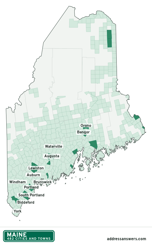
Maine city limits map image
The map above as a picture: every Maine city and town in green, with county lines. Boundaries from the Census Bureau, as of January 1, 2025.
You’re welcome to use it in a document or on your own site, with a link back to this page.
Download the map (PNG, 604 × 972)Questions about Maine city limits
How many cities and towns are in Maine?
Maine has 482 incorporated places: 23 cities, 430 towns, and 29 plantations, by the Census Bureau’s boundary files for 2025.
What is the largest city in Maine?
By population, Portland, with about 68,854 residents (2020–2024 American Community Survey 5-year estimates). By land area the largest is Allagash, at 128.6 square miles (Portland: 21.5).
What is the smallest plantation in Maine?
By the Census Bureau’s estimate, Glenwood, with 6 residents. Estimates for places this small have a wide margin of error, so treat it as a rough count.
Which county in Maine has the most cities and towns?
Aroostook County, with 64 at least partly inside it. Every county in Maine has at least one.
Bordering states
More answers for a Maine address
Each tool checks the same address and puts its own answer first.
- County Census Your county, plus the township or town where those exist. Find your county
- School district Census The public school district that covers the address. Find your school district
- Flood zone FEMA The FEMA zone in plain English, and whether lenders require flood insurance. Check flood zone
- USDA home loans USDA Whether the property is in an area eligible for a USDA Rural Development loan. Check USDA eligibility
- Voting districts Census Your congressional district and your state senate and state house districts. Included in every check
Places, boundaries, land area and counties: US Census Bureau 2025 cartographic boundary files (boundaries as of January 1, 2025). A place is listed in each county that holds at least 1% of its land. Population: 2020–2024 American Community Survey 5-year estimates. Data updated October 24, 2026; page updated October 25, 2026. Boundaries change through annexation; your city or county has the official map.