Alaska city limits map
Alaska has 149 incorporated places: 148 cities and 1 municipality. They cover 2.1% of the state’s land and are home to 67% of its residents. Everyone else lives outside city limits, where local government is the borough, or the state where there is no borough. Enter an address to see which side of a city line it’s on.
Result for
The map couldn’t load. The answers don’t depend on it.
The boundary couldn’t load. The answer doesn’t depend on it.
Census Geocoder match
More about this address
Sources and limits
- Census
- US Census Bureau Geocoder, current boundaries
- FEMA
- National Flood Hazard Layer, effective flood maps
- USDA
- Rural Development property eligibility
- Map
- Boundaries from Census TIGERweb, flood zones drawn by FEMA, eligible areas from USDA, base map © OpenStreetMap contributors
Census boundaries are updated once a year, so a recent annexation may not show yet. Informational only, not an official determination. Verify with your city or county.
Alaska at a glance
- Incorporated places
- 149
- 148 cities and 1 municipality
- Residents in city limits
- 67%
- 496,559 of 735,706
- Land in city limits
- 2.1%
- 12,229 of 571,390 sq mi
- Boroughs and census areas
- 30
- 5 with no city
- Unincorporated communities
- 206
- Largest: Knik-Fairview (19,972)
- Largest city
- Anchorage
- 288,976 residents
How local government works in Alaska
Alaska has boroughs instead of counties. 19 are organized boroughs with their own governments; the rest of the state, the Unorganized Borough, has none, and the Census Bureau splits it into 11 census areas. Many Alaska cities are small villages with a city government of their own.
City limits map for Anchorage
Its own page has the boundary in detail, the communities around it and its school districts.
All 149 cities in Alaska
Every incorporated place, largest first, with the boroughs and census areas it’s in and its size. An address inside one of these is inside city limits; anywhere else in the state is unincorporated.
| Name | Type | Borough or census area | Population | Land (sq mi) |
|---|---|---|---|---|
| Anchorage | Municipality | Anchorage Municipality | 288,976 | 1,707 |
| Fairbanks | City | Fairbanks North Star Borough | 32,083 | 31.8 |
| Juneau | City | Juneau City and Borough | 31,794 | 2,703 |
| Wasilla | City | Matanuska-Susitna Borough | 9,720 | 12.4 |
| Sitka | City | Sitka City and Borough | 8,368 | 2,870 |
| Ketchikan | City | Ketchikan Gateway Borough | 8,078 | 3.83 |
| Kenai | City | Kenai Peninsula Borough | 7,641 | 29.1 |
| Bethel | City | Bethel Census Area | 6,312 | 45.1 |
| Palmer | City | Matanuska-Susitna Borough | 6,268 | 5.07 |
| Homer | City | Kenai Peninsula Borough | 5,877 | 13.8 |
| Kodiak | City | Kodiak Island Borough | 5,447 | 3.93 |
| Utqiaġvik | City | North Slope Borough | 4,778 | 18.8 |
| Unalaska | City | Aleutians West Census Area | 4,556 | 102.1 |
| Soldotna | City | Kenai Peninsula Borough | 4,485 | 6.93 |
| Valdez | City | Chugach Census Area | 3,847 | 211.7 |
| Nome | City | Nome Census Area | 3,653 | 12.7 |
| Kotzebue | City | Northwest Arctic Borough | 2,984 | 24.4 |
| Seward | City | Kenai Peninsula Borough | 2,794 | 14.0 |
| Cordova | City | Chugach Census Area | 2,453 | 61.4 |
| North Pole | City | Fairbanks North Star Borough | 2,370 | 4.09 |
| Dillingham | City | Dillingham Census Area | 2,109 | 33.2 |
| Wrangell | City | Wrangell City and Borough | 2,088 | 2,556 |
| Houston | City | Matanuska-Susitna Borough | 1,834 | 23.9 |
| King Cove | City | Aleutians East Borough | 1,352 | 24.7 |
| Quinhagak | City | Bethel Census Area | 1,311 | 4.25 |
| Delta Junction | City | Southeast Fairbanks Census Area | 1,217 | 13.9 |
| Craig | City | Prince of Wales-Hyder Census Area | 1,131 | 6.69 |
| Sand Point | City | Aleutians East Borough | 1,064 | 8.01 |
| Kotlik | City | Kusilvak Census Area | 976 | 2.99 |
| Kwethluk | City | Bethel Census Area | 975 | 10.1 |
| Emmonak | City | Kusilvak Census Area | 966 | 5.07 |
| Togiak | City | Dillingham Census Area | 963 | 41.9 |
| Mountain Village | City | Kusilvak Census Area | 949 | 4.20 |
| Hooper Bay | City | Kusilvak Census Area | 903 | 7.28 |
| Savoonga | City | Nome Census Area | 868 | 5.87 |
| Alakanuk | City | Kusilvak Census Area | 864 | 32.0 |
| Hoonah | City | Hoonah-Angoon Census Area | 862 | 5.87 |
| Toksook Bay | City | Bethel Census Area | 833 | 28.8 |
| Point Hope | City | North Slope Borough | 832 | 5.02 |
| St. Mary's | City | Kusilvak Census Area | 810 | 44.5 |
| Kivalina | City | Northwest Arctic Borough | 809 | 1.63 |
| Kachemak | City | Kenai Peninsula Borough | 805 | 1.67 |
| Klawock | City | Prince of Wales-Hyder Census Area | 749 | 0.68 |
| Noorvik | City | Northwest Arctic Borough | 748 | 0.92 |
| Brevig Mission | City | Nome Census Area | 718 | 2.34 |
| Wainwright | City | North Slope Borough | 718 | 10.3 |
| Pilot Station | City | Kusilvak Census Area | 713 | 1.60 |
| Akutan | City | Aleutians East Borough | 694 | 66.0 |
| Manokotak | City | Dillingham Census Area | 679 | 73.7 |
| Fort Yukon | City | Yukon-Koyukuk Census Area | 656 | 6.71 |
| Kake | City | Prince of Wales-Hyder Census Area | 624 | 7.67 |
| Chefornak | City | Bethel Census Area | 620 | 5.18 |
| Nunapitchuk | City | Bethel Census Area | 618 | 6.99 |
| Nuiqsut | City | North Slope Borough | 616 | 8.63 |
| Galena | City | Yukon-Koyukuk Census Area | 611 | 17.8 |
| Stebbins | City | Nome Census Area | 596 | 32.6 |
| Gustavus | City | Hoonah-Angoon Census Area | 594 | 34.9 |
| Aniak | City | Bethel Census Area | 585 | 6.13 |
| Gambell | City | Nome Census Area | 569 | 10.6 |
| Napakiak | City | Bethel Census Area | 556 | 1.89 |
| Buckland | City | Northwest Arctic Borough | 533 | 0.71 |
| Thorne Bay | City | Prince of Wales-Hyder Census Area | 519 | 26.7 |
| Unalakleet | City | Nome Census Area | 519 | 2.85 |
| Chevak | City | Kusilvak Census Area | 494 | 1.09 |
| Angoon | City | Hoonah-Angoon Census Area | 480 | 24.5 |
| Nenana | City | Yukon-Koyukuk Census Area | 479 | 6.23 |
| New Stuyahok | City | Dillingham Census Area | 474 | 34.4 |
| Shishmaref | City | Nome Census Area | 466 | 2.31 |
| Napaskiak | City | Bethel Census Area | 447 | 2.85 |
| Scammon Bay | City | Kusilvak Census Area | 440 | 0.46 |
| Kiana | City | Northwest Arctic Borough | 437 | 0.19 |
| Selawik | City | Northwest Arctic Borough | 412 | 1.98 |
| Whittier | City | Chugach Census Area | 411 | 12.3 |
| Marshall | City | Kusilvak Census Area | 386 | 4.06 |
| Elim | City | Nome Census Area | 383 | 2.63 |
| St. Paul | City | Aleutians West Census Area | 378 | 41.6 |
| Akiak | City | Bethel Census Area | 377 | 2.15 |
| Hydaburg | City | Prince of Wales-Hyder Census Area | 375 | 0.29 |
| Koyuk | City | Nome Census Area | 348 | 5.10 |
| Tanana | City | Yukon-Koyukuk Census Area | 334 | 10.7 |
| Anaktuvuk Pass | City | North Slope Borough | 329 | 5.18 |
| Saxman | City | Ketchikan Gateway Borough | 324 | 0.97 |
| Russian Mission | City | Kusilvak Census Area | 314 | 5.37 |
| Atqasuk | City | North Slope Borough | 288 | 39.1 |
| Mekoryuk | City | Bethel Census Area | 287 | 7.07 |
| Shaktoolik | City | Nome Census Area | 283 | 1.07 |
| Coffman Cove | City | Prince of Wales-Hyder Census Area | 269 | 10.9 |
| McGrath | City | Yukon-Koyukuk Census Area | 255 | 43.2 |
| Nulato | City | Yukon-Koyukuk Census Area | 255 | 41.1 |
| Teller | City | Nome Census Area | 255 | 1.49 |
| Lower Kalskag | City | Bethel Census Area | 239 | 1.23 |
| Upper Kalskag | City | Bethel Census Area | 239 | 3.61 |
| Wales | City | Nome Census Area | 238 | 2.24 |
| Ruby | City | Yukon-Koyukuk Census Area | 237 | 7.02 |
| Deering | City | Northwest Arctic Borough | 227 | 5.01 |
| White Mountain | City | Nome Census Area | 222 | 1.80 |
| Holy Cross | City | Yukon-Koyukuk Census Area | 205 | 29.2 |
| Seldovia | City | Kenai Peninsula Borough | 202 | 0.39 |
| Ambler | City | Northwest Arctic Borough | 182 | 10.3 |
| Golovin | City | Nome Census Area | 181 | 4.13 |
| St. Michael | City | Nome Census Area | 177 | 21.7 |
| Eek | City | Bethel Census Area | 174 | 0.62 |
| Grayling | City | Yukon-Koyukuk Census Area | 173 | 11.2 |
| Allakaket | City | Yukon-Koyukuk Census Area | 167 | 15.8 |
| Tenakee Springs | City | Hoonah-Angoon Census Area | 163 | 13.1 |
| Old Harbor | City | Kodiak Island Borough | 162 | 16.2 |
| Akhiok | City | Kodiak Island Borough | 160 | 7.40 |
| False Pass | City | Aleutians East Borough | 151 | 25.1 |
| Port Lions | City | Kodiak Island Borough | 150 | 4.99 |
| Shungnak | City | Northwest Arctic Borough | 147 | 8.04 |
| Cold Bay | City | Aleutians East Borough | 145 | 52.5 |
| Larsen Bay | City | Kodiak Island Borough | 145 | 4.03 |
| Anderson | City | Denali Borough | 140 | 41.9 |
| Kaktovik | City | North Slope Borough | 124 | 0.77 |
| Newhalen | City | Lake and Peninsula Borough | 122 | 5.95 |
| Goodnews Bay | City | Bethel Census Area | 115 | 3.33 |
| Nondalton | City | Lake and Peninsula Borough | 103 | 6.73 |
| Kobuk | City | Northwest Arctic Borough | 101 | 15.3 |
| Eagle | City | Southeast Fairbanks Census Area | 95 | 0.89 |
| Nightmute | City | Bethel Census Area | 93 | 98.8 |
| Aleknagik | City | Dillingham Census Area | 92 | 26.2 |
| Ouzinkie | City | Kodiak Island Borough | 86 | 5.54 |
| Chuathbaluk | City | Bethel Census Area | 82 | 4.47 |
| Anvik | City | Yukon-Koyukuk Census Area | 79 | 9.59 |
| Adak | City | Aleutians West Census Area | 73 | 29.6 |
| Port Heiden | City | Lake and Peninsula Borough | 73 | 46.2 |
| St. George | City | Aleutians West Census Area | 70 | 34.4 |
| Kaltag | City | Yukon-Koyukuk Census Area | 68 | 23.1 |
| Pelican | City | Hoonah-Angoon Census Area | 58 | 0.55 |
| Egegik | City | Lake and Peninsula Borough | 54 | 28.8 |
| Whale Pass | City | Prince of Wales-Hyder Census Area | 54 | 19.9 |
| Huslia | City | Yukon-Koyukuk Census Area | 51 | 15.7 |
| Kasaan | City | Prince of Wales-Hyder Census Area | 51 | 6.06 |
| Port Alexander | City | Prince of Wales-Hyder Census Area | 50 | 3.94 |
| Pilot Point | City | Lake and Peninsula Borough | 48 | 23.9 |
| Nikolai | City | Yukon-Koyukuk Census Area | 44 | 4.36 |
| Platinum | City | Bethel Census Area | 43 | 47.3 |
| Hughes | City | Yukon-Koyukuk Census Area | 40 | 3.04 |
| Ekwok | City | Dillingham Census Area | 36 | 17.1 |
| Shageluk | City | Yukon-Koyukuk Census Area | 34 | 10.3 |
| Koyukuk | City | Yukon-Koyukuk Census Area | 29 | 5.75 |
| Chignik | City | Lake and Peninsula Borough | 27 | 10.8 |
| Diomede | City | Nome Census Area | 27 | 2.43 |
| Clark's Point | City | Dillingham Census Area | 25 | 3.32 |
| Edna Bay | City | Prince of Wales-Hyder Census Area | 25 | 21.1 |
| Bettles | City | Yukon-Koyukuk Census Area | 16 | 1.57 |
| Atka | City | Aleutians West Census Area | 15 | 8.13 |
| Kupreanof | City | Petersburg Borough | 10 | 3.02 |
| Nunam Iqua | City | Kusilvak Census Area | 0 | 12.1 |
Showing 1–50 of 149
Unincorporated communities in Alaska
Census-designated places: named communities the Census Bureau maps for statistics, with no city government of their own. An address in one is outside city limits, even when its mailing address names a city. Alaska has 206.
| Community | Borough or census area | Population | Land (sq mi) |
|---|---|---|---|
| Knik-Fairview | Matanuska-Susitna Borough | 19,972 | 73.5 |
| Badger | Fairbanks North Star Borough | 18,677 | 65.8 |
| College | Fairbanks North Star Borough | 11,924 | 18.8 |
| North Lakes | Matanuska-Susitna Borough | 10,223 | 15.5 |
| Tanaina | Matanuska-Susitna Borough | 9,646 | 30.3 |
| Meadow Lakes | Matanuska-Susitna Borough | 8,689 | 75.5 |
| Kalifornsky | Kenai Peninsula Borough | 8,663 | 69.1 |
| Gateway | Matanuska-Susitna Borough | 6,845 | 18.4 |
| Sterling | Kenai Peninsula Borough | 6,323 | 77.7 |
| South Lakes | Matanuska-Susitna Borough | 6,180 | 7.80 |
| Steele Creek | Fairbanks North Star Borough | 5,928 | 92.9 |
| Chena Ridge | Fairbanks North Star Borough | 5,881 | 36.4 |
| Fishhook | Matanuska-Susitna Borough | 5,819 | 65.2 |
| Farmers Loop | Fairbanks North Star Borough | 4,954 | 21.8 |
| Nikiski | Kenai Peninsula Borough | 4,773 | 69.5 |
| Butte | Matanuska-Susitna Borough | 4,085 | 33.8 |
| Mill Bay | Kodiak Island Borough | 3,654 | 3.44 |
| Big Lake | Matanuska-Susitna Borough | 3,585 | 115.3 |
| Goldstream | Fairbanks North Star Borough | 3,294 | 86.0 |
| Petersburg | Petersburg Borough | 3,227 | 44.2 |
| Eielson AFB | Fairbanks North Star Borough | 3,155 | 29.9 |
| Farm Loop | Matanuska-Susitna Borough | 2,894 | 9.11 |
| Ester | Fairbanks North Star Borough | 2,752 | 64.2 |
| Fritz Creek | Kenai Peninsula Borough | 2,383 | 53.9 |
| Anchor Point | Kenai Peninsula Borough | 2,243 | 91.7 |
| Deltana | Southeast Fairbanks Census Area | 1,997 | 568.6 |
| Ridgeway | Kenai Peninsula Borough | 1,997 | 16.8 |
| Kodiak Station | Kodiak Island Borough | 1,823 | 23.2 |
| Willow | Matanuska-Susitna Borough | 1,815 | 690.4 |
| Haines | Haines Borough | 1,757 | 13.3 |
| Bear Creek | Kenai Peninsula Borough | 1,732 | 38.3 |
| Point MacKenzie | Matanuska-Susitna Borough | 1,668 | 162.3 |
| Prudhoe Bay | North Slope Borough | 1,664 | 390.4 |
| Tok | Southeast Fairbanks Census Area | 1,649 | 132.9 |
| Cohoe | Kenai Peninsula Borough | 1,598 | 70.4 |
| Sutton-Alpine | Matanuska-Susitna Borough | 1,598 | 57.6 |
| Susitna North | Matanuska-Susitna Borough | 1,566 | 276.0 |
| Lazy Mountain | Matanuska-Susitna Borough | 1,459 | 58.6 |
| Diamond Ridge | Kenai Peninsula Borough | 1,329 | 42.4 |
| Metlakatla | Prince of Wales-Hyder Census Area | 1,235 | 2.31 |
| Skagway | Skagway Municipality | 1,174 | 9.47 |
| Salamatof | Kenai Peninsula Borough | 1,149 | 8.03 |
| Funny River | Kenai Peninsula Borough | 1,081 | 26.8 |
| Ninilchik | Kenai Peninsula Borough | 965 | 207.2 |
| Talkeetna | Matanuska-Susitna Borough | 944 | 94.2 |
| Knik River | Matanuska-Susitna Borough | 883 | 81.7 |
| Salcha | Fairbanks North Star Borough | 829 | 75.2 |
| Denali Park | Denali Borough | 819 | 176.5 |
| Pleasant Valley | Fairbanks North Star Borough | 790 | 31.1 |
| Womens Bay | Kodiak Island Borough | 788 | 43.9 |
| Noatak | Northwest Arctic Borough | 786 | 16.0 |
| Happy Valley | Kenai Peninsula Borough | 775 | 88.4 |
| Fox River | Kenai Peninsula Borough | 741 | 125.4 |
| Buffalo Soapstone | Matanuska-Susitna Borough | 739 | 22.1 |
| Akiachak | Bethel Census Area | 736 | 7.01 |
| Kipnuk | Bethel Census Area | 706 | 20.1 |
| Kasigluk | Bethel Census Area | 698 | 10.5 |
| Healy | Denali Borough | 670 | 686.8 |
| South Van Horn | Fairbanks North Star Borough | 572 | 7.87 |
| Big Delta | Southeast Fairbanks Census Area | 565 | 47.1 |
| Kwigillingok | Bethel Census Area | 545 | 23.7 |
| Yakutat | Yakutat City and Borough | 527 | 100.4 |
| Naknek | Bristol Bay Borough | 522 | 81.4 |
| Tuntutuliak | Bethel Census Area | 514 | 116.0 |
| Moose Creek | Fairbanks North Star Borough | 507 | 1.56 |
| Trapper Creek | Matanuska-Susitna Borough | 491 | 320.1 |
| Two Rivers | Fairbanks North Star Borough | 451 | 27.7 |
| Glennallen | Copper River Census Area | 450 | 115.2 |
| Point Lay | North Slope Borough | 390 | 28.5 |
| Tununak | Bethel Census Area | 384 | 60.8 |
| Tazlina | Copper River Census Area | 365 | 8.44 |
| Copper Center | Copper River Census Area | 346 | 12.3 |
| Chickaloon | Matanuska-Susitna Borough | 333 | 67.1 |
| King Salmon | Bristol Bay Borough | 323 | 167.2 |
| Kongiganak | Bethel Census Area | 316 | 13.2 |
| Kasilof | Kenai Peninsula Borough | 313 | 10.3 |
| Glacier View | Matanuska-Susitna Borough | 308 | 232.3 |
| Tyonek | Kenai Peninsula Borough | 291 | 68.0 |
| Kenny Lake | Copper River Census Area | 289 | 194.5 |
| Harding-Birch Lakes | Fairbanks North Star Borough | 277 | 214.2 |
| Nikolaevsk | Kenai Peninsula Borough | 245 | 34.9 |
| Clam Gulch | Kenai Peninsula Borough | 238 | 13.3 |
| Cooper Landing | Kenai Peninsula Borough | 227 | 65.8 |
| Minto | Yukon-Koyukuk Census Area | 214 | 131.9 |
| Seldovia Village | Kenai Peninsula Borough | 213 | 18.1 |
| Coldfoot | Yukon-Koyukuk Census Area | 211 | 35.8 |
| Moose Pass | Kenai Peninsula Borough | 202 | 17.7 |
| Nanwalek | Kenai Peninsula Borough | 199 | 8.12 |
| Port Alsworth | Lake and Peninsula Borough | 199 | 22.6 |
| Koliganek | Dillingham Census Area | 193 | 16.7 |
| Northway | Southeast Fairbanks Census Area | 192 | 242.4 |
| Gakona | Copper River Census Area | 181 | 60.7 |
| Pitkas Point | Kusilvak Census Area | 169 | 1.61 |
| Halibut Cove | Kenai Peninsula Borough | 167 | 8.32 |
| Arctic Village | Yukon-Koyukuk Census Area | 164 | 63.6 |
| Dry Creek | Southeast Fairbanks Census Area | 162 | 140.2 |
| Tanacross | Southeast Fairbanks Census Area | 155 | 79.1 |
| Nelchina | Copper River Census Area | 149 | 46.9 |
| Willow Creek | Copper River Census Area | 144 | 37.0 |
| Eareckson Station | Aleutians West Census Area | 129 | 5.48 |
| Cantwell | Denali Borough | 128 | 119.0 |
| Tetlin | Southeast Fairbanks Census Area | 123 | 67.8 |
| Slana | Copper River Census Area | 119 | 252.7 |
| Tuluksak | Bethel Census Area | 118 | 2.93 |
| Mosquito Lake | Haines Borough | 116 | 77.2 |
| Fort Greely | Southeast Fairbanks Census Area | 111 | 11.0 |
| Central | Yukon-Koyukuk Census Area | 108 | 247.9 |
| Chitina | Copper River Census Area | 100 | 84.7 |
| Skwentna | Matanuska-Susitna Borough | 97 | 438.6 |
| Mentasta Lake | Copper River Census Area | 96 | 300.7 |
| Primrose | Kenai Peninsula Borough | 89 | 34.5 |
| Atmautluak | Bethel Census Area | 88 | 1.52 |
| Twin Hills | Dillingham Census Area | 87 | 22.8 |
| Port Graham | Kenai Peninsula Borough | 83 | 6.40 |
| Klukwan | Hoonah-Angoon Census Area | 82 | 1.26 |
| Perryville | Lake and Peninsula Borough | 82 | 11.6 |
| Chalkyitsik | Yukon-Koyukuk Census Area | 80 | 8.65 |
| Fox | Fairbanks North Star Borough | 80 | 13.0 |
| Mud Bay | Haines Borough | 79 | 12.1 |
| Nelson Lagoon | Aleutians East Borough | 78 | 188.1 |
| Tolsona | Copper River Census Area | 76 | 45.6 |
| Venetie | Yukon-Koyukuk Census Area | 76 | 23.0 |
| South Naknek | Bristol Bay Borough | 73 | 88.2 |
| Silver Springs | Copper River Census Area | 71 | 2.54 |
| Iliamna | Lake and Peninsula Borough | 70 | 37.0 |
| Hollis | Prince of Wales-Hyder Census Area | 66 | 65.1 |
| Naukati Bay | Prince of Wales-Hyder Census Area | 66 | 4.79 |
| Crown Point | Kenai Peninsula Borough | 65 | 3.57 |
| Excursion Inlet | Haines Borough | 62 | 56.4 |
| Chistochina | Copper River Census Area | 58 | 368.3 |
| Circle | Yukon-Koyukuk Census Area | 54 | 106.0 |
| Igiugig | Lake and Peninsula Borough | 53 | 21.2 |
| Petersville | Matanuska-Susitna Borough | 53 | 461.8 |
| Sleetmute | Bethel Census Area | 48 | 97.9 |
| Gulkana | Copper River Census Area | 47 | 34.9 |
| Tonsina | Copper River Census Area | 47 | 159.0 |
| Oscarville | Bethel Census Area | 42 | 2.51 |
| Mendeltna | Copper River Census Area | 41 | 450.9 |
| Kokhanok | Lake and Peninsula Borough | 39 | 20.7 |
| Chenega | Chugach Census Area | 37 | 29.3 |
| Newtok | Bethel Census Area | 36 | 0.73 |
| Karluk | Kodiak Island Borough | 33 | 55.9 |
| Manley Hot Springs | Yukon-Koyukuk Census Area | 32 | 54.6 |
| Susitna | Matanuska-Susitna Borough | 31 | 216.0 |
| Chase | Matanuska-Susitna Borough | 29 | 168.7 |
| Chignik Lagoon | Lake and Peninsula Borough | 29 | 13.2 |
| Stony River | Bethel Census Area | 29 | 3.17 |
| Elfin Cove | Hoonah-Angoon Census Area | 28 | 168.4 |
| Chignik Lake | Lake and Peninsula Borough | 27 | 13.7 |
| Port Protection | Prince of Wales-Hyder Census Area | 27 | 3.71 |
| Eagle Village | Southeast Fairbanks Census Area | 24 | 17.0 |
| Healy Lake | Southeast Fairbanks Census Area | 24 | 66.8 |
| Lutak | Haines Borough | 24 | 127.0 |
| Sunrise | Kenai Peninsula Borough | 23 | 13.0 |
| Ferry | Denali Borough | 22 | 63.5 |
| Tatitlek | Chugach Census Area | 20 | 7.25 |
| Whitestone | Southeast Fairbanks Census Area | 18 | 7.13 |
| Beaver | Yukon-Koyukuk Census Area | 17 | 20.5 |
| Crooked Creek | Bethel Census Area | 17 | 100.6 |
| Evansville | Yukon-Koyukuk Census Area | 17 | 22.8 |
| Paxson | Copper River Census Area | 17 | 304.0 |
| Port Clarence | Nome Census Area | 16 | 34.1 |
| Covenant Life | Haines Borough | 15 | 27.1 |
| Takotna | Yukon-Koyukuk Census Area | 15 | 23.4 |
| Hyder | Prince of Wales-Hyder Census Area | 14 | 17.1 |
| Pedro Bay | Lake and Peninsula Borough | 14 | 19.3 |
| Attu Station | Aleutians West Census Area | 13 | 142.1 |
| Mertarvik | Bethel Census Area | 12 | 6.89 |
| Alatna | Yukon-Koyukuk Census Area | 11 | 36.9 |
| Levelock | Lake and Peninsula Borough | 8 | 16.7 |
| Lake Minchumina | Yukon-Koyukuk Census Area | 7 | 226.8 |
| Beluga | Kenai Peninsula Borough | 4 | 99.2 |
| Ugashik | Lake and Peninsula Borough | 4 | 255.0 |
| Alcan Border | Southeast Fairbanks Census Area | 3 | 151.7 |
| McCarthy | Copper River Census Area | 3 | 149.6 |
| Red Devil | Bethel Census Area | 3 | 25.2 |
| Nikolski | Aleutians West Census Area | 1 | 132.4 |
| Portage Creek | Dillingham Census Area | 1 | 13.2 |
| Aleneva | Kodiak Island Borough | 0 | 62.2 |
| Birch Creek | Yukon-Koyukuk Census Area | 0 | 7.98 |
| Chicken | Southeast Fairbanks Census Area | 0 | 115.9 |
| Chiniak | Kodiak Island Borough | 0 | 38.7 |
| Chisana | Copper River Census Area | 0 | 79.4 |
| Dot Lake | Southeast Fairbanks Census Area | 0 | 295.0 |
| Dot Lake Village | Southeast Fairbanks Census Area | 0 | 4.38 |
| Eureka Roadhouse | Matanuska-Susitna Borough | 0 | 185.6 |
| Flat | Yukon-Koyukuk Census Area | 0 | 160.3 |
| Four Mile Road | Yukon-Koyukuk Census Area | 0 | 1.13 |
| Game Creek | Hoonah-Angoon Census Area | 0 | 5.89 |
| Hobart Bay | Petersburg Borough | 0 | 119.4 |
| Hope | Kenai Peninsula Borough | 0 | 51.7 |
| Ivanof Bay | Lake and Peninsula Borough | 0 | 4.19 |
| Lake Louise | Matanuska-Susitna Borough | 0 | 55.8 |
| Lime Village | Bethel Census Area | 0 | 76.5 |
| Livengood | Yukon-Koyukuk Census Area | 0 | 265.3 |
| Loring | Ketchikan Gateway Borough | 0 | 0.55 |
| Lowell Point | Kenai Peninsula Borough | 0 | 11.7 |
| Nabesna | Copper River Census Area | 0 | 160.3 |
| Point Baker | Prince of Wales-Hyder Census Area | 0 | 0.88 |
| Point Possession | Kenai Peninsula Borough | 0 | 42.0 |
| Pope-Vannoy Landing | Lake and Peninsula Borough | 0 | 56.9 |
| Rampart | Yukon-Koyukuk Census Area | 0 | 169.8 |
| Red Dog Mine | Northwest Arctic Borough | 0 | 68.0 |
| Stevens Village | Yukon-Koyukuk Census Area | 0 | 11.8 |
| Whitestone Logging Camp | Hoonah-Angoon Census Area | 0 | 11.0 |
| Wiseman | Yukon-Koyukuk Census Area | 0 | 78.0 |
Showing 1–50 of 206
Boroughs and census areas in Alaska
30 boroughs and census areas, with how many cities have land in each and the largest whose main borough or census area it is.
| Borough or census area | Cities | Largest | Population | Land (sq mi) |
|---|---|---|---|---|
| Anchorage Municipality | 1 | Anchorage | 288,976 | 1,707 |
| Matanuska-Susitna Borough | 3 | Wasilla | 112,988 | 24,707 |
| Fairbanks North Star Borough | 2 | Fairbanks | 95,460 | 7,335 |
| Kenai Peninsula Borough | 6 | Kenai | 60,413 | 16,018 |
| Juneau City and Borough | 1 | Juneau | 31,794 | 2,703 |
| Bethel Census Area | 18 | Bethel | 18,394 | 40,655 |
| Ketchikan Gateway Borough | 2 | Ketchikan | 13,768 | 4,857 |
| Kodiak Island Borough | 6 | Kodiak | 12,771 | 6,690 |
| North Slope Borough | 7 | Utqiaġvik | 10,810 | 88,793 |
| Nome Census Area | 16 | Nome | 9,866 | 22,970 |
| Sitka City and Borough | 1 | Sitka | 8,368 | 2,870 |
| Kusilvak Census Area | 12 | Kotlik | 8,176 | 17,152 |
| Northwest Arctic Borough | 10 | Kotzebue | 7,441 | 35,672 |
| Southeast Fairbanks Census Area | 2 | Delta Junction | 7,068 | 24,839 |
| Chugach Census Area | 3 | Valdez | 6,862 | 9,574 |
| Prince of Wales-Hyder Census Area | 10 | Craig | 5,715 | 5,268 |
| Aleutians West Census Area | 5 | Unalaska | 5,235 | 4,387 |
| Yukon-Koyukuk Census Area | 18 | Fort Yukon | 5,195 | 145,768 |
| Dillingham Census Area | 7 | Dillingham | 4,724 | 18,353 |
| Aleutians East Borough | 5 | King Cove | 3,491 | 6,985 |
| Petersburg Borough | 1 | Kupreanof | 3,409 | 2,901 |
| Copper River Census Area | 0 | None | 2,626 | 24,647 |
| Hoonah-Angoon Census Area | 5 | Hoonah | 2,311 | 6,560 |
| Wrangell City and Borough | 1 | Wrangell | 2,088 | 2,556 |
| Haines Borough | 0 | None | 2,086 | 2,335 |
| Denali Borough | 1 | Anderson | 1,969 | 12,640 |
| Skagway Municipality | 0 | None | 1,244 | 442.9 |
| Lake and Peninsula Borough | 6 | Newhalen | 1,013 | 23,897 |
| Bristol Bay Borough | 0 | None | 918 | 481.4 |
| Yakutat City and Borough | 0 | None | 527 | 7,628 |
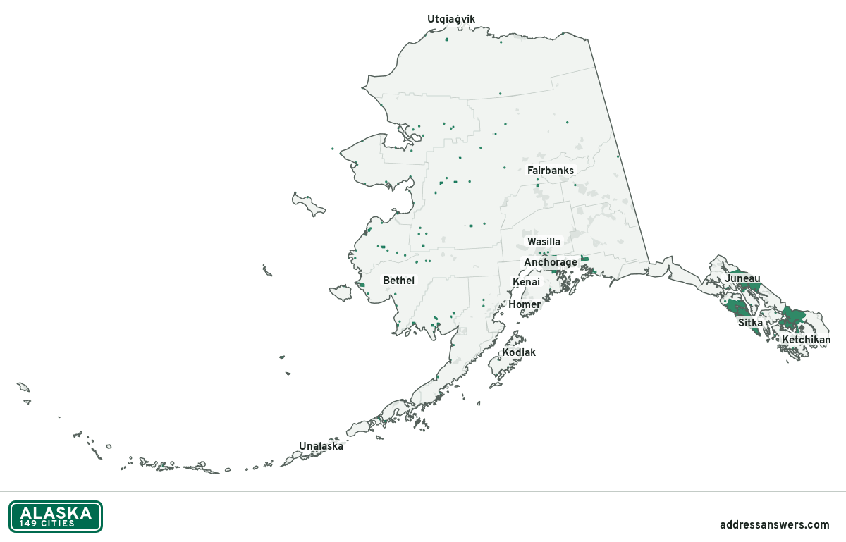
Alaska city limits map image
The map above as a picture: every Alaska city and town in green, with county lines. Boundaries from the Census Bureau, as of January 1, 2025.
You’re welcome to use it in a document or on your own site, with a link back to this page.
Download the map (PNG, 1,200 × 769)Questions about Alaska city limits
How many cities are in Alaska?
Alaska has 149 incorporated places: 148 cities and 1 municipality, by the Census Bureau’s boundary files for 2025.
What is the largest city in Alaska?
By population, Anchorage, with about 288,976 residents (2020–2024 American Community Survey 5-year estimates). By land area the largest is Sitka, at 2,870 square miles (Anchorage: 1,707).
What is the smallest city in Alaska?
By the Census Bureau’s estimate, Kupreanof, with 10 residents. Estimates for places this small have a wide margin of error, so treat it as a rough count.
How much of Alaska is unincorporated?
98% of its land and 239,147 of its residents (33%) are outside every city. There, local government is the borough, or the state where there is no borough. The state also has 206 named unincorporated communities; the largest is Knik-Fairview.
Is Knik-Fairview, AK a city?
No. Knik-Fairview is a census-designated place: a community the Census Bureau maps for statistics, with no city government of its own. About 19,972 people live there, in unincorporated Matanuska-Susitna Borough. An address there is outside city limits, even if its mailing address says otherwise.
Is Badger, AK a city?
No. Badger is a census-designated place: a community the Census Bureau maps for statistics, with no city government of its own. About 18,677 people live there, in unincorporated Fairbanks North Star Borough. An address there is outside city limits, even if its mailing address says otherwise.
Which borough or census area in Alaska has the most cities?
Bethel Census Area, with 18 at least partly inside it. Five boroughs and census areas have none.
More answers for a Alaska address
Each tool checks the same address and puts its own answer first.
- County Census Your county, plus the township or town where those exist. Find your county
- School district Census The public school district that covers the address. Find your school district
- Flood zone FEMA The FEMA zone in plain English, and whether lenders require flood insurance. Check flood zone
- USDA home loans USDA Whether the property is in an area eligible for a USDA Rural Development loan. Check USDA eligibility
- Voting districts Census Your congressional district and your state senate and state house districts. Included in every check
Places, boundaries, land area and boroughs and census areas: US Census Bureau 2025 cartographic boundary files (boundaries as of January 1, 2025). A place is listed in each borough or census area that holds at least 1% of its land. Population: 2020–2024 American Community Survey 5-year estimates. Data updated October 24, 2026; page updated October 25, 2026. Boundaries change through annexation; your city or borough or census area has the official map.